
Nationally consistent and regularly updated ground cover information is a critical indicator for environmental targets related to soil erosion and land management in Australia. Ground cover or vegetation cover reduces soil erosion, increases water infiltration, enables carbon sequestration and contributes to agricultural production of food and fibre.
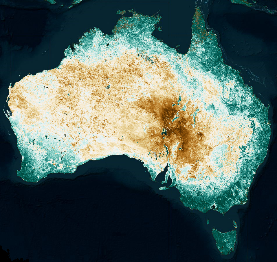
Vegetation cover can now be monitored and reported regularly against regional targets, across Australia, using satellite imagery. Explore vegetation cover for Australia online using the Rangelands and Pasture Productivity RAPP Map tool.
To set and report against soil erosion protection targets for your region read the 2020 report: Setting targets for National Landcare Program monitoring and reporting vegetation cover for Australia.
This nationally agreed, reliable and cost-effective, validated method has been developed collaboratively. Funding was received through the National Landcare Program Regional Land Partnerships and previously Caring for our Country. Other major contributors include New South Wales government, CSIRO, Rangelands and Pasture Productivity (RAPP) map as part of the Group on Earth Observation Global Agricultural Monitoring (GEOGLAM), Regional Agricultural Landcare Facilitators, and previous work by ACLUMP partners.
Metrics for monitoring vegetation cover are also used in a framework of resilience indicators being developed for long-term monitoring alongside implementation of the Future Drought Fund.
See Glossary for definitions of terms such as: Ground cover, Vegetation cover and Fractional cover.
Ground cover monitoring products available as at August 2023:
RAPP (Rangelands and Pasture Productivity) Map is an online tool to monitor and report monthly fractional cover.
- Analyse 500m monthly fractional cover from MODIS from 2001 to current
- View 30m monthly fractional cover blended from Landsat and Sentinel-2 from 2016 to current
- Generate reports for regions, areas or locations
- Access last month's report for Natural Resource Management Regions from a map
- Get started with the online help and videos on YouTube
- Developed and supported by CSIRO, Data61, GEOGLAM, National Landcare Program.
VegMachine is an online tool to monitor and report seasonal fractional cover.
- Analyse 30m seasonal fractional cover from Landsat
- Generate reports for areas
- Estimate soil erosion rates
- Developed by Fitzroy Basin Association, Commonwealth and Queensland Government
- See more about ground cover from Queensland Government.
Vegetation cover metrics for the Future Drought Fund provided in an interactive dashboard.
- Track against regional targets the protection of agricultural land from soil erosion
- 500m monthly Total Vegetation Cover from MODIS is used for monitoring
- The regional targets used for the Future Drought Fund will differ to those used for reporting under the National Landcare Program Regional Land Partnerships. This is a result of differing baseline periods used to calculate the targets.
- These metrics are not designed to measure direct impacts of Future Drought Fund projects.
Access monthly MODIS derived vegetation fractional cover data
- Web mapping services (WMS) can be used in GIS software with this URL http://gsky.nci.org.au/ows/geoglam (Note: You will need access to GIS or mapping software to use this link as it will not open in your web browser.)
- Download gridded spatial data in GeoTIFF format for Australia.
Access monthly Landsat/Sentinel-2 derived fractional cover data
- Access data in GeoTIFF format from the CSIRO Portal Index of /remotesensing/landsat-s2-fc (csiro.au)
- Web mapping services (WMS) can be used in GIS software with this URL https://ows.csiro.easi-eo.solutions/wms?service=WMS&version=1.3.0&request=GetCapabilities (Note: You will need access to GIS or mapping software to use this link as it will not open in your web browser.)
- 2022, Hill and Guerschman, Global trends in vegetation fractional cover: Hotspots for change in bare soil and non-photosynthetic vegetation. Agriculture, Ecosystems & Environment 324
- 2020, Guerschman et. al. Vegetation cover dependence on accumulated antecedent precipitation in Australia: Relationships with photosynthetic and non-photosynthetic vegetation fractions. Remote Sensing of Environment 240, 111620
- 2018, Guerschman and Hill, Calibration and validation of the Australian fractional cover product for MODIS collection 6, Remote Sensing Letter 9 (7), 696-705
- 2015, Guerschman et. al. Assessing the effects of site heterogeneity and soil properties when unmixing photosynthetic vegetation, non-photosynthetic vegetation and bare soil fractions from Landsat and MODIS data, Remote Sensing of Environment 161, 12-26
- 2009, Guerschman et. al. Estimating fractional cover of photosynthetic vegetation, non-photosynthetic vegetation, and bare soil in the Australian tropical savannah region upscaling the EO-1 Hyperion and MODIS sensors, Remote Sensing of Environment, 113 (5) 928-945
- 2018 Effective Field Calibration and validation practices, Chapter 18: A calibration and validation framework to support ground cover monitoring for Australia, Terrestrial Ecosystem Research Network (TERN)
- 2014 Australian ground cover reference sites database package on the Data.gov.au - PostGRES database September 2014
- 2014 Australian ground cover reference sites databases for each participating jurisdiction on TERN - New South Wales, Northern Territory, Queensland, South Australia, Tasmania, Victoria, and Western Australia.
- 2013 Sampling strategy - March 2013 PDF [2.2 MB]
- 2012, Evaluation of the MODIS-based vegetation fractional cover product - April 2012 CSIRO PDF [3.3 MB]
- 2011 Technical handbook describing agreed national standards for the field measurement of fractional ground cover to support remote sensing products - November 2011
- Forms for entry of fractional cover field data site description form Excel [656 KB], transect form Excel [262 KB], PDF [959 KB]
- 2023, Monitoring management-driven changes in total vegetation cover. A methods report for the National Landcare Program
- 2023, Total vegetation cover products and stakeholder engagement: RaPP Map
- 2023, Is the total vegetation cover what is expected given the antecedent rainfall?
- 2020, Setting targets for National Landcare Program Monitoring and reporting vegetation cover for Australia
- 2018, Monitoring ground cover: an online tool for Australian regions
- 2014, Ground cover monitoring for Australia Final project report to June 2013
- 2013, Ground cover monitoring for Australia Progress report July 2011 to June 2012
- 2012, Ground cover monitoring for Australia Project progress report to June 2011- May 2012 PDF [2.1 MB]
- Poster describing version 3 ground cover algorithm - Presented at "Frontiers in Earth Observation for Land System Science" Berlin, March 2014 PDF [2.8 MB]
- Poster on ground cover products - Presented at "Land transformations: Between global challenges and local realities" Berlin, March 2014 PDF [2.4 MB]
- Poster on ground cover remote sensing methods - Presented at the Terrestrial Ecosystems Research Network symposium February 2013 PDF [3 MB]
- Progress in national ground cover monitoring for Australian agriculture from the Joint Australian and New Zealand Soil Science Conference- December 2012 DOC [192 KB}
- Workshop proceedings from November 2009 Ground cover monitoring for Australia - Establishing a nationally coordinated approach to ground cover mapping
- Ground cover monitoring for MERI - 2018 PDF [1.96 MB]
- Ground cover monitoring for Australia factsheet - November 2012
- Ground cover monitoring for Australia factsheet - 2010 PDF [681 KB]