
The area of forest land where priority is given to protecting soil and hydrological functions provides an indication of the emphasis being placed by society on the conservation of these values. This indicator includes areas managed to protect soil and water by excluding incompatible activities.
This is the Key information for Indicator 4.1a. The first section below was published in October 2024. The second section was added in April 2026.
- A total of 37.0 million hectares (28%) of Australia’s forest is managed for protection of soil and water values, most of which is native forest.
- The area of forest managed primarily for protection of soil and water values includes formal nature conservation reserves, informal reserves in multiple-use public native forests, forests protected by prescription and forested catchments managed specifically for water supply.
- There are 1.2 million hectares of forest on land managed exclusively to supply water for human or industrial use.
- There has been a slight increase in the area and proportion of forest managed for protection of soil and water values since the last report in 2018.
Forests are vital for soil conservation, preventing soil erosion, protecting water supplies and maintaining other ecosystem functions. Relevant state and territory regulations and guidelines that provide for sustainable forest management are designed to minimise soil erosion (Indicator 4.1b), protect soil physical properties (Indicator 4.1c), manage activities that could affect water yields and quality (Indicator 4.1d), and manage risks to water quality (Indicator 4.1e). State and territory based processes are also in place to monitor and ensure compliance with measures that protect forest soil and water resources.
A total of 37.0 million hectares of forest is managed for protection of soil and water values, and comprised largely of native forest with smaller areas of commercial plantations and other forest. This is 28% of Australia’s total forest area of 133.6 million hectares (Table 4.1a-1), and represents an increase in both the area and proportion reported in Australia’s State of the Forests Report 2018 (36.6 million hectares and 27%, respectively).
The area of forest managed primarily for protection of soil and water values includes formal nature conservation reserves, informal reserves in multiple-use public forests, forests protected by prescription (such as steep slopes, erodible soil types and riparian (streamside) zones where harvesting and road construction are not permitted), and forested catchments managed specifically for water supply.
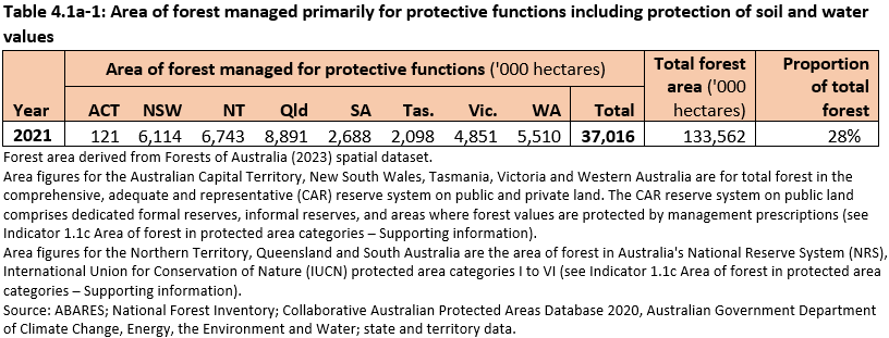
Click here for a Microsoft Excel workbook of the data for Table 4.1a-1.
[This section was published in October 2024.]
A total of 1.2 million hectares of forest is on land managed exclusively to supply water for human or industrial use (Table 4.1a-2). This area is largely on publicly owned land but includes private land managed by government agencies for the purpose of protecting water resources. This includes forests within protected or closed reservoir catchments, water source areas, water reserves and other areas managed specifically for the supply of water. These forested areas are regulated by legislation, with public access and activities generally restricted. Disturbance activities, such as wood harvesting, are minimised to maintain water quality and quantity values.
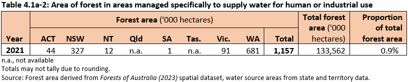
Click here for a Microsoft Excel workbook of the data for Table 4.1a-2.
- In the Australian Capital Territory, 44 thousand hectares of forest managed for water consumption are in the Cotter River Catchment, which is largely within Namadgi National Park.
- In New South Wales, 327 thousand hectares of forested land occurs within the 364 thousand hectares of protected and special areas in the Greater Sydney catchment areas managed for water consumption. Public access and activities are restricted within these areas under the Water NSW Act 2014. This includes forest on all tenure classes, including private land owned by the NSW government and managed by WaterNSW to protect water quality and quantity.
- In the Northern Territory, 12 thousand hectares of forest are within the Darwin River Dam and Manton River Dam catchments, which are the primary and emergency water supply catchments for Darwin.
- Information is unavailable on forest on areas in Queensland regulated specifically for the supply of drinking water. However, there are 23 major catchment areas that are managed for multiple uses, including the supply of drinking water. Southeast Queensland’s catchments cover about 1.2 million hectares in supplying drinking water to Brisbane and surrounding areas of southeast Queensland1.
- In South Australia, 1 thousand hectares of forest are within the 10 catchments in the Mount Lofty Ranges Catchment area that supplies water to Adelaide and surrounds.
- In Tasmania, there is no statewide area figure available for forest in catchments explicitly managed for water harvest, however two reserves contain explicitly recognised drinking water catchments to supply Hobart and surrounds. The Lake Fenton/Lady Barron Creek drinking water catchment covers 1,530 hectares of Mount Field National Park and part of Wellington Park is also specifically set aside and managed as a drinking water source (FPA 2022).
- In Victoria, 91 thousand hectares of forest are in catchments that supply water to Melbourne. These areas are protected, with disturbance activities excluded. An additional 8.3 million hectares of land is within catchments managed for the supply of water; however, disturbance activities are not excluded within these catchments.
- In Western Australia, 681 thousand hectares of forest are within public drinking-water source areas, including both protected catchment areas and the water recharge areas of groundwater sources.
[This section was published in April 2026.]
References
ABARES (2023). Forests of Australia (2023), Australian Bureau of Agricultural and Resource Economics and Sciences, Canberra, December. CC BY 4.0. doi.org/10.25814/6cay-a361
FPA (2022). State of the forests Tasmania 2022: Data report. Forest Practices Authority, Hobart, Tasmania.