
This indicator (Indicator 1.1a) uses the area for each forest type over time as a broad measure of the extent to which forest ecosystems and their diversity are being maintained. Reporting on forest tenure aids our understanding of how different land management regimes may impact on forest biodiversity.
This part of Indicator 1.1a Area of forest by forest type and tenure, published December 2023, presents the area of Australia’s forests by forest type.
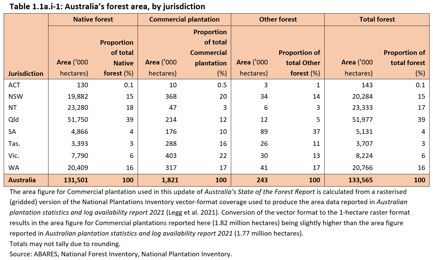
- Australia has 133.6 million hectares of forest, covering 17% of Australia’s land area, of which
- 131.5 million hectares are Native forests
- 1.82 million hectares are Commercial plantation*
- 0.24 million hectares are Other forest.
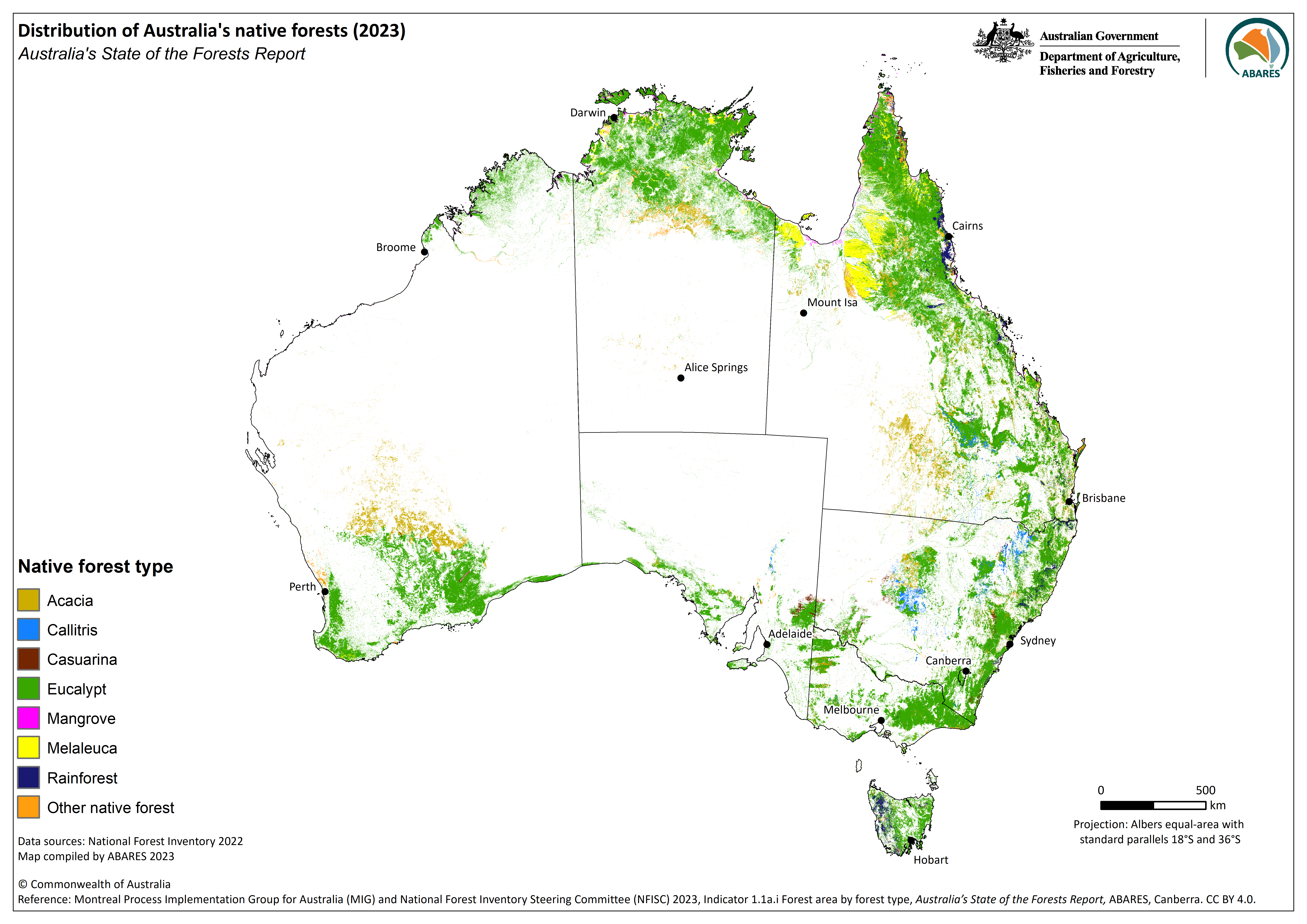
- Australia’s forests are dominated by Eucalypt forests (101 million hectares, 77% of total native forest)
- Acacia forests (10.9 million hectares, 8% of total native forest) and Rainforest (3.44 million hectares, 3% of total native forest) cover significant areas.
- Structurally, most of Australia’s native forest is woodland forest (93 million hectares, 71% of total native forest), with a crown cover of 20–50%.
*The area of Commercial plantation reported here differs from the area published by the National Plantation Inventory which are compiled from non-spatial data sources that cannot be integrated with the national spatial (mapped) total forest area dataset required to identify the area of all forests in Australia.
Australia’s State of the Forests Report is based on Australia’s national definition of forest:
An area, incorporating all living and non-living components, that is dominated by trees having usually a single stem and a mature or potentially mature stand height exceeding 2 metres and with existing or potential crown cover of overstorey strata about equal to or greater than 20 per cent. This includes Australia’s diverse native forests and plantations, regardless of age. It is also sufficiently broad to encompass areas of trees that are sometimes described as woodlands.
Woodland, savanna and eucalypt mallee vegetation are all included where they meet the criteria for height and crown cover.
Australia’s national definition of forest is different from the definitions of forest that apply in some other countries, or the definition used by the Food and Agriculture Organization of the United Nations (FAO).
In Australia’s National Forest Inventory, forests are assigned to three broad categories: Native forest, Commercial plantation and Other forest. Each of these categories is divided into various forest types.
The Native forest category comprises areas dominated by the suite of native tree species naturally associated with forest in that location and located within their natural range. Native forest is classified into eight forest types defined by dominant species or structure, namely Acacia, Callitris, Casuarina, Eucalypt, Mangrove, Melaleuca, Rainforest and Other native forest types. The ‘Other native forest’ type comprises a range of less common native forest types with relatively small individual areas, as well as native forest where the type is unknown.
Native forest is also divided into three crown cover classes (Closed, Open and Woodland), and three height classes (Tall, Medium and Low). The Eucalypt forest type is also sub-divided into mallee and non-mallee subtypes.
The Commercial plantation category comprises hardwood or softwood plantations managed commercially to supply logs for the manufacture of wood products, and reported through the National Plantation Inventory. There are three types:
- Softwood (predominantly radiata pine, Pinus radiata, in southern Australia, and southern pine varieties, Pinus spp., in Queensland)
- Hardwood (most commonly Tasmanian blue gum, Eucalyptus globulus)
- Other (sometimes referred to as Unknown or Mixed species).
The Other forest category comprises mostly non commercial plantations and planted forests of various types, including plantations of sandalwood (Santalum spp.), smaller farm forestry and agroforestry plantations, environmental plantings, plantations within the reserve system, and plantations regarded as non-commercial. It also includes non-planted forests dominated by trees of introduced species.
Sparse woody vegetation is not reported in Australia’s State of the Forests Report. This is a non-forest vegetation type of open woodland, heathland or shrubland, generally with a tree crown cover of 5-20%.
Australia has 133.6 million hectares of forest, covering 17% of Australia’s total land area (Table 1.1a.i-1, showing data as at 2021). Australia has the seventh largest area of forest in the world by country, and approximately 3% of the world’s forest area.
The areas of forest in the three broad categories of Australia’s forest estate are as follows:
- Native forest: 131.5 million hectares (98% of Australia’s total forest area). Queensland has the largest area of native forest (39% of Australia’s native forest area), with much of the balance in the Northern Territory (18%), Western Australia (16%), and New South Wales (15%).
- Commercial plantations: 1.82 million hectares (1.4% of Australia’s total forest area). Victoria has the largest area of commercial plantations (22% of Australia’s commercial plantation area), with New South Wales (20%), Western Australia (17%), Tasmania (16%) and Queensland (12%) making up the balance.
- Other forest: 0.24 million hectares (0.18%) of Australia’s total forest area. The largest areas of Other forest are in South Australia (0.09 million hectares) and Western Australia (0.04 million hectares). All Other forest in the Northern Territory is sandalwood plantations.
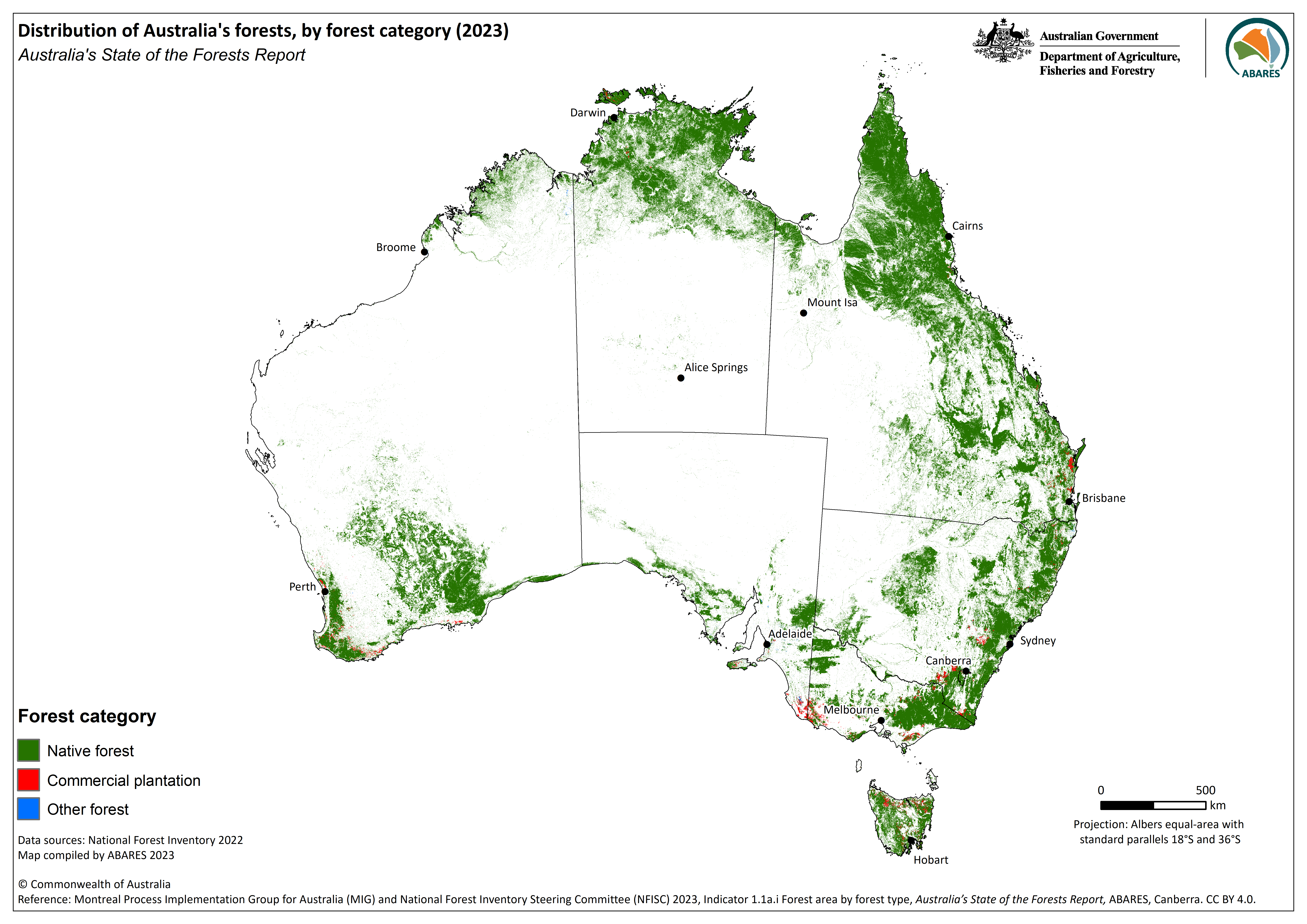
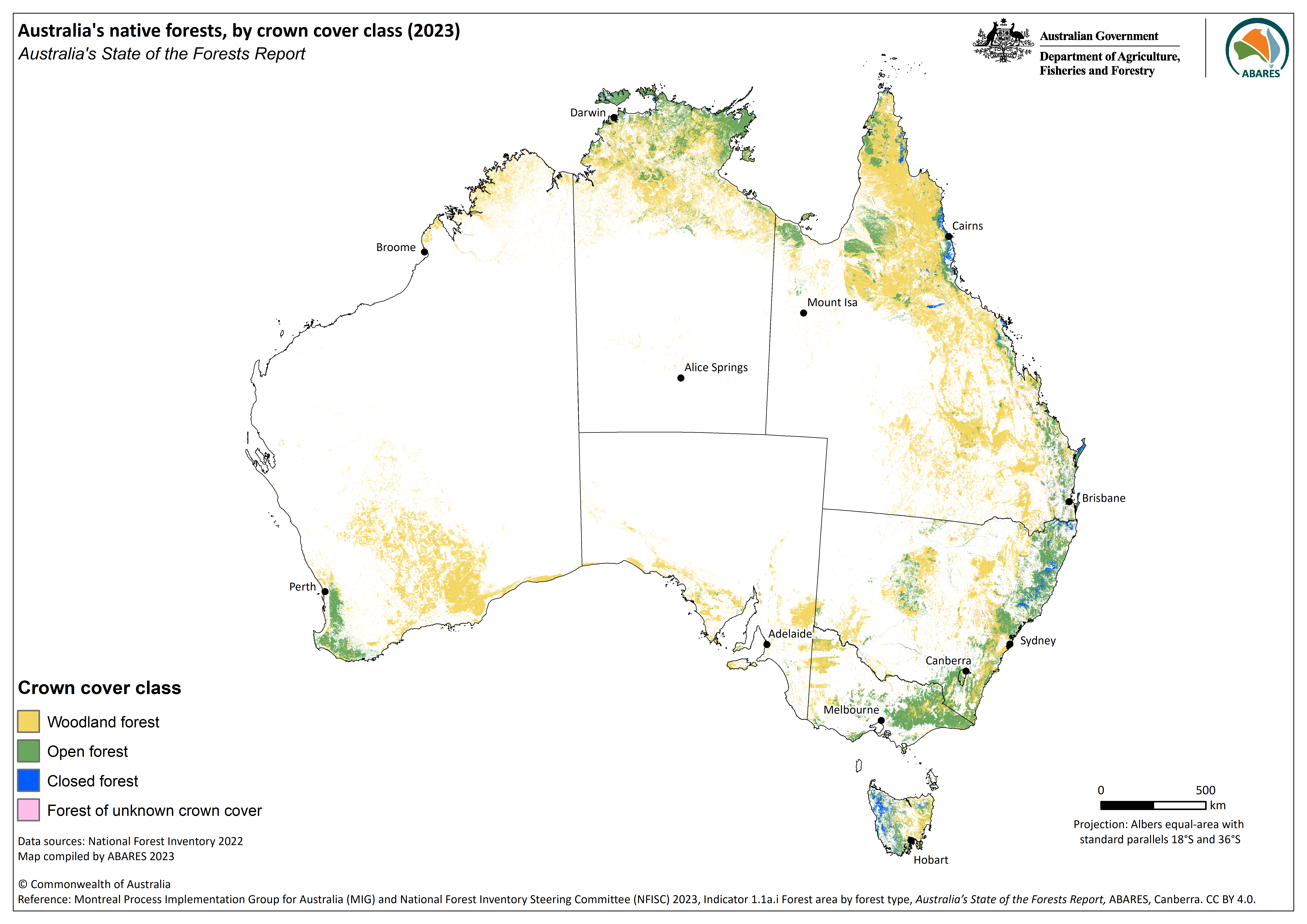
The geographic distribution of Australia’s forests is shown in Figure 1.1a.i-1, by forest category. Forests are generally confined to regions where average rainfall exceeds 500 millimetres per year. Most forests are in the northern, eastern, south-eastern and south-western coastal zones of Australia, although woodland forests extend into drier areas in many parts of the country.
Click here for a Microsoft Excel workbook of the data for Table 1.1a.i-1.

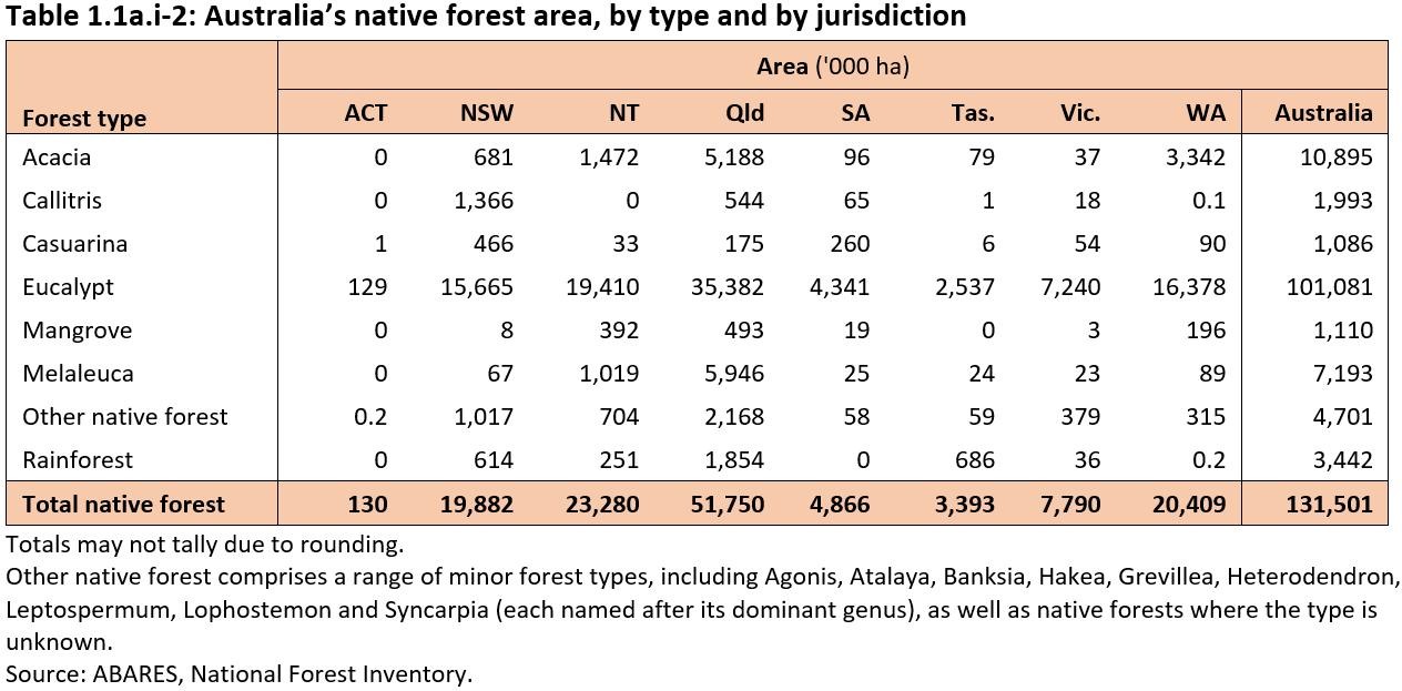
The Native forest category is dominated by Eucalypt (77% by area) and Acacia (8%) hardwood forest types (Table 1.1a.i-2). Callitris, the only native forest type dominated by coniferous (softwood) tree species, makes up 2% of native forests. The Rainforest forest type accounts for 3% of native forests, and includes tropical, subtropical, warm-temperate, cool-temperate and dry rainforests.
Click here for a Microsoft Excel workbook of the data for Table 1.1a.i-2.
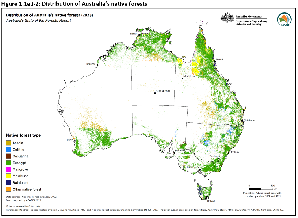
The geographic distribution of Australia’s forests by forest type is shown in Figure 1.1a.i-2. Eucalypt forests dominate in all jurisdictions, and are most dominant in the Australian Capital Territory (99% of its native forest area) and least dominant in Queensland (68%). The largest areas of Eucalypt, Acacia, Melaleuca, Rainforest and Mangrove forest types occur in Queensland, and the largest areas of Callitris and Casuarina forest are in New South Wales. Rainforest does not occur in South Australia or the Australian Capital Territory at this scale of analysis.
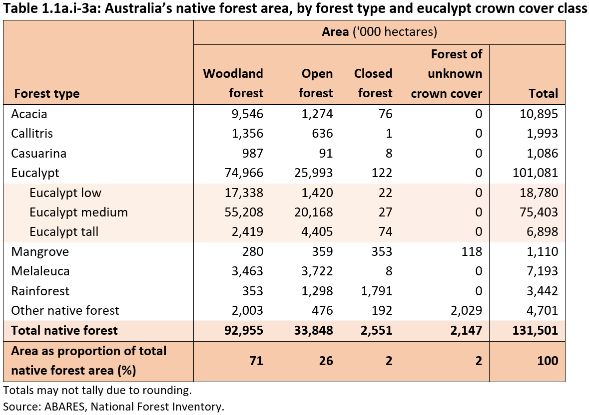
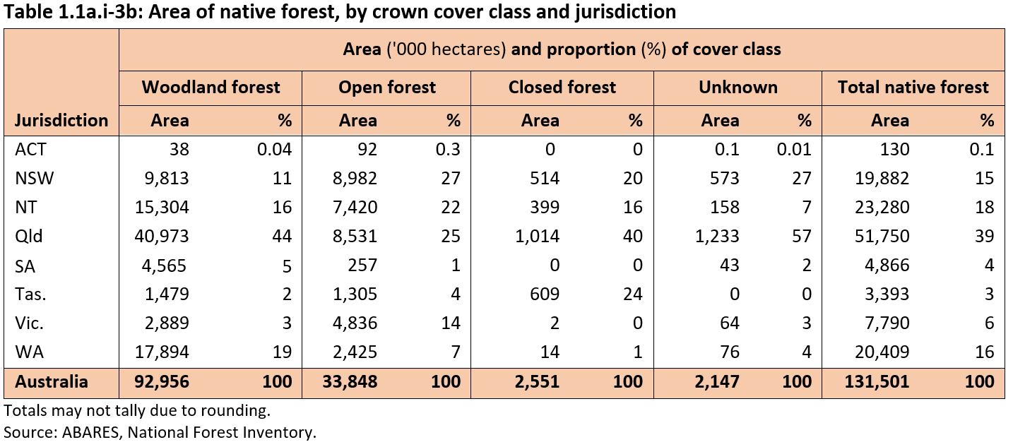
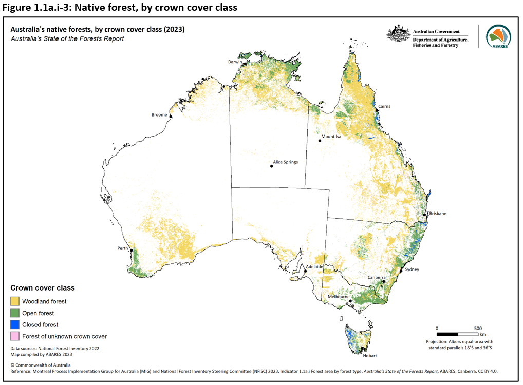
Australia’s native forests (98% of Australia’s total forest area) are classified into nine structural classes based on three crown cover classes and three stand height classes (Table 1.1a.i-3a and Table 1.1a.i-3b).
The three native forest crown cover classes are:
- Woodland forest (93 million hectares, 71% of Australia’s total forest area)
- Open forest (34 million hectares, 26% of Australia’s total forest area)
- Closed forest (2.6 million hectares, 2% of Australia’s total forest area).
Eucalypt forest types are the largest components of both Woodland and Open forests, while Rainforest is the largest component of Closed forest. Woodland forest is also the largest component of forest in all jurisdictions except Victoria and the Australian Capital Territory where Open forests dominate. Table 1.1a.i-3a and Table 1.1a.i-3b provide more data on the three crown cover classes.
The three stand height classes are Low, Medium and Tall. Separate area figures for height classes are less accurate than for crown cover, but are provided in Figure 1.1a.i-4 in Supporting information for Indicator 1.1a.i.
Eucalypt mallee forest also is separated as a distinct subtype within the Eucalypt forest type (see Table 1.1a.i-6 in Supporting information for Indicator 1.1a.i).
The distribution of Australia’s native forest types and structural classes varies across the continent (Figure 1.1a.i-3), depending on climate, soil type and fire history, and is related to soil moisture regimes and water availability, as well as land management practices.
- Woodland forests dominate drier areas, often inland.
- Open forests dominate higher rainfall regions located in the south-eastern, south-western and northern parts of the country.
- Closed forests are found in western Tasmania, north-eastern Queensland, north-eastern New South Wales, and coastal Northern Territory where rainfall is high.
Click here for a Microsoft Excel workbook of the data for Table 1.1a.i-3a.
Click here for a Microsoft Excel workbook of the data for Table 1.1a.i-3b.
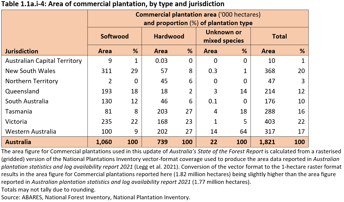
Australia has 1.82 million hectares of Commercial plantations (1.4% of Australia’s total forest area). This comprises (Table 1.1a.i-4):
- 1.06 million hectares of softwood plantations (58% of Commercial plantation area)
- 0.74 million hectares of hardwood plantations (41% of Commercial plantation area)
- 0.02 million hectares of unknown or mixed species commercial plantations (1% of Commercial plantation area).
Click here for a Microsoft Excel workbook of the data for Table 1.1a.i-4.
Commercial plantations are established in both temperate and tropical regions. Most commercial softwood plantations are in New South Wales (0.31 million hectares, 29% of Australia’s total softwood plantation area), Victoria (0.24 million hectares, 22%) and Queensland (0.19 million hectares, 18%). Most commercial hardwood plantations are found in Tasmania and Western Australia (each with 0.20 million hectares and 27% of Australia’s total hardwood plantation area) and Victoria (0.17 million hectares, 23%).
The Other forest category comprises 0.24 million hectares (0.2% of total forest area) (Table 1.1a.i-1). This category is dominated by plantations not reported as managed for commercial wood production, and so not listed as Commercial plantations in the National Plantation Inventory. It also contains environmental plantings, sandalwood plantations, and some smaller farm forestry and agroforestry plantations. South Australia has the largest area of Other forest (0.09 million hectares, 38% of the total Other forest area). All Other forest in the Northern Territory is sandalwood plantations.
The Commercial plantation category plus the planted proportion of the Other forest category comprise the ‘Planted forests’ category used by the Food and Agriculture Organization (FAO) of the United Nations for the five-yearly Global Forest Resources Assessment.
Further information
Click here for Supporting information on 1.1a.i Forest area by forest type, including:
- Native forest crown cover and stand height classes
- Mapping forest for the 2023 update of Australia’s State of the Forests Report
- Differences between the forest area reported in SOFR 2018 and the forest area reported in the 2023 SOFR update
- Datasets driving increased accuracy of forest area determination
- Reallocation forest to non-forest
- Reallocation of non-forest to forest