Key issues
- During the week ending 1 September 2021, high pressure systems across much of the west and centre of Australia resulted in little rainfall across much of the continent. Low pressure systems and associated cold front to the south and east of Australia brought rainfall to parts of the far south, while tropical low-pressure troughs brought heavy rainfall to north-eastern Australia.
- Most Australian cropping regions currently have average to above average soil moisture levels, which would have supported ongoing crop growth despite the dry conditions. Rainfall in the cropping areas of central Queensland likely increased plant available moisture, as soil moisture levels have been below average.
- Rainfall during August 2021 was below average across much of southern Australia and average to above average in northern Australia. Rainfall was below average in western New South Wales, parts of south-east Queensland, central and western Victoria, most of South Australia and much of southern and central Western Australia. Rainfall was well below average in isolated parts of New South Wales, South Australia and Western Australia. Rainfall in August 2021 was above average to well above average for south-eastern New South Wales, northern Queensland, eastern Victoria, as well as isolated parts of northern Western Australia and the Northern Territory.
- Winter 2021 rainfall was 4% below the national long-term average but was the highest winter rainfall since 2016, with a negative Indian Ocean Dipole (IOD) and a fluctuating Southern Annular Mode (SAM) influencing Australia’s climate for parts of the season. Rainfall was above average to well above average across large areas of eastern New South Wales, central Queensland, parts of southern Victoria, South Australia and Western Australia, as well as the north of the Northern Territory.
- A trough of low-pressure systems is expected to track eastwards across Australia and is likely to result in rainfall across the south-east and parts of central Australia in the middle of the week. High pressure systems are anticipated to bring clear skies and dry conditions across much of Australia over the remainder of the week The forecast rainfall for New South Wales and Victoria is likely to top up soil moisture levels and bolster yield potentials heading into spring. Above average soil moisture levels in southern Queensland, South Australia and Western Australia will support ongoing crop development, but further rainfall is required to realise strong yield prospects.
- Water storage in the Murray–Darling Basin (MDB) increased by 482 gigalitres (GL) between 24 August 2021 and 31 August 2021. The current volume of water held in storage is 20,624 GL, which represents 81% of total capacity. This is 47% or 6,557 GL more than at the same time last year.
- Allocation prices in the Victorian Murray below the Barmah Choke increased from $123 per ML on 20 August 2021 to $150 per ML on 28 August 2021. Prices are lower in the Goulburn-Broken, Murrumbidgee, and regions above the Barmah choke due to the binding of the Goulburn intervalley trade limit, Murrumbidgee export limit, and Barmah choke trade constraint.
Climate
[expand all]
Rainfall this week
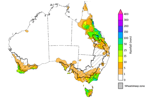
During the week ending 1 September 2021, high pressure systems across much of the west and centre of Australia resulted in little rainfall across much of the continent. Low pressure systems and associated cold front to the south and east of Australia brought rainfall to parts of the far south, while tropical low-pressure troughs brought heavy rainfall to north-eastern Australia.
Rainfall totals of between 10 and 50 millimetres were recorded in south-east New South Wales, north-east Queensland, eastern Victoria, the south of South Australia, the far southwest of Western Australia and western Tasmania. Rainfall totals in excess of 50 millimetres were recorded in isolated parts of south-east New South Wales, north-east Queensland, eastern Victoria and western Tasmania.
In cropping regions, rainfall totals of between 10 and 50 millimetres were recorded in northern Queensland, and isolated areas of South Australia and Western Australia. Little to no rainfall was recorded across the remainder of Australian cropping regions.
Most Australian cropping regions currently have average to above average soil moisture levels, which would have supported ongoing crop growth despite the dry conditions. Rainfall in the cropping areas of central Queensland likely increased plant available moisture, as soil moisture levels have been below average. Most cropping regions would benefit from further rainfall as winter crops enter critical flowering and grain development stages in spring.
Rainfall for the week ending 1 September 2021
©Commonwealth of Australia 2021, Australian Bureau of Meteorology - Issued: 01/09/2021
Note: The rainfall analyses and associated maps utilise data contained in the Bureau of Meteorology climate database, the Australian Data Archive for Meteorology (ADAM). The analyses are initially produced automatically from real-time data with limited quality control. They are intended to provide a general overview of rainfall across Australia as quickly as possible after the observations are received. For further information go to http://www.bom.gov.au/climate/rainfall/
Monthly temperatures
August 2021 was the sixth warmest August on record and 1.39°C above the long-term average. The mean maximum temperature was 1.78°C above average, and the mean minimum temperature was 0.99°C above average.
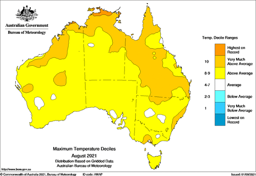
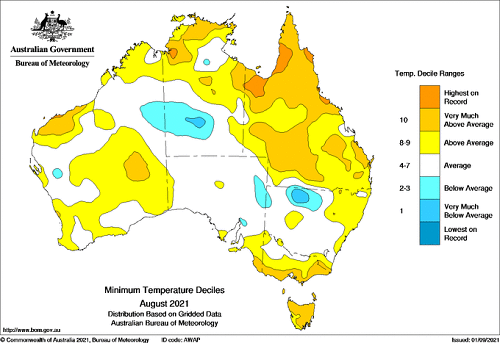
Maximum temperatures for August were very much above average for northern Australia, as well as parts of eastern Australia. Isolated parts of northern Australia also experienced record maximum temperatures. Maximum temperatures in the remaining parts of Australia were mostly above average. Minimum temperatures were above average to very much above average across much of north-eastern Australia and isolated parts of south-eastern Australia. Minimum temperatures were below average to very much below average in isolated parts of central Australia. Above average temperatures and ample plant available soil moisture are likely to have driven rapid development of winter crops throughout August.
Maximum temperature deciles for August 2021
©Commonwealth of Australia 2021, Australian Bureau of Meteorology - Issued: 01/09/2021
Minimum temperature deciles for August 2021
©Commonwealth of Australia 2021, Australian Bureau of Meteorology - Issued: 01/09/2021
Monthly rainfall
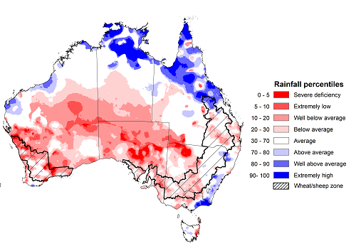
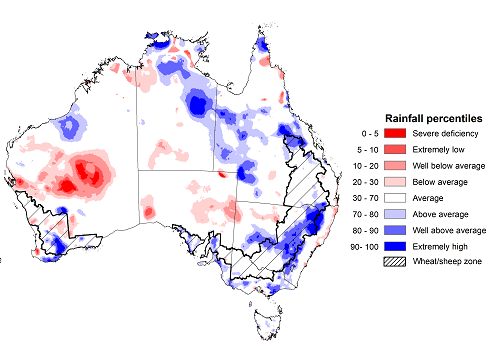
Rainfall during August 2021 was below average across much of southern Australia and average to above average in northern Australia. Rainfall was below average in western New South Wales, parts of south-east Queensland, central and western Victoria, most of South Australia and much of southern and central Western Australia. Rainfall was well below average in isolated parts of New South Wales, South Australia and Western Australia. Rainfall in August 2021 was above average to well above average for south-eastern New South Wales, northern Queensland, eastern Victoria, as well as isolated parts of northern Western Australia and the Northern Territory.
The Indian Ocean Dipole (IOD) was negative for much of August, but tended toward neutral values, while the Southern Annular Mode (SAM) fluctuated from negative to positive towards the end of August. A negative IOD is associated with above average sea surface temperatures near Western Australia and can result in moisture-laden air moving across the continent and increasing rainfall in southern Australia. At this time of year, a positive SAM usually results in above average rainfall for eastern Australia and below average rainfall for southern Australia. The slight weakening of the negative IOD event in August and the fluctuating effect of the SAM has contributed to below average rainfall across much of southern Australia during August. An east coast low pressure system brought heavy falls to isolated parts of eastern Australia towards the end of August.
August rainfall was below average to average across cropping regions in much of southern New South Wales, southern and central Queensland, Victoria, South Australia and Western Australia. Rainfall was above average in isolate parts of northern New South Wales and northern Queensland cropping regions.
Above average rainfall through June and July likely provided plentiful plant available water to support crop development throughout a drier than average August, and the dry conditions have allowed farmers to access fields. Further rainfall will be required in the coming weeks to maintain the strong yield potentials expected across most cropping regions.
Rainfall percentiles for August 2021
Note: Rainfall for May 2021 is compared with rainfall recorded for that period during the historical record (1900 to present). For further information, go to http://www.bom.gov.au/water/ Source: Bureau of Meteorology
Seasonal rainfall
Winter 2021 rainfall was 4% below the national long-term average but was the highest winter rainfall since 2016, with a negative Indian Ocean Dipole (IOD) and a fluctuating Southern Annular Mode (SAM) influencing Australia’s climate for parts of the season. Rainfall was above average to well above average across parts of eastern New South Wales, central Queensland, parts of southern Victoria, South Australia and Western Australia, as well as the north of the Northern Territory.
The season began with above average or better rainfall across most cropping regions in New South Wales, Queensland, eastern Victoria, central South Australia and the south of Western Australia. Parts of western Victoria and eastern South Australia experienced dry conditions early in the season, but above rainfalls in July improved soil moisture levels. The above average rainfall in June and July improved soil moisture levels across most cropping regions, supporting the establishment and development of winter crops. However, localised waterlogging impacted parts of New South Wales and the south of Western Australia. The wet conditions also prevented field access for post-emergence crop management activities. Below average to average rainfall in August, however, enabled drainage of saturated soil profiles and access to fields.
At the end of the season, winter crops across most regions are in above average condition, with close to record yields expected in Western Australia and southern Queensland. Spring rainfall will support yield potentials as we enter critical development stages (flowering and grain filling), in which crops are most sensitive to water deficiencies.
Rainfall percentiles for winter 2021 (1 June to 31 August 2021)
Note: Rainfall for March 2021 to May 2021 is compared with rainfall recorded for that period during the historical record (1900 to present). For further information, go to http://www.bom.gov.au/water/ Source: Bureau of Meteorology
Monthly soil moisture
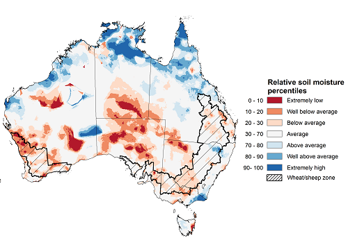
Upper layer soil moisture in August 2021 was below average for this time of year across parts of southern, central and eastern Australia, following below average rainfall throughout the month. However, modelled upper layer soil moisture was above average to well above average across large parts of northern Australia, as well as isolated parts of central and south-eastern Australia.
Upper layer soil moisture was below average to average for this time of year across cropping regions in southern and central New South Wales, Queensland, Victoria, parts of South Australia and Western Australia. Upper layer soil moisture was above average for isolated parts of northern New South Wales. At this time of year, upper layer soil moisture is less critical for well-established winter crops. However, upper layer soil moisture will be critical for supporting the germination and establishment of summer crops in the coming months.
Modelled upper layer soil moisture for August 2021
Note: This map shows the levels of modelled upper layer soil moisture (0 to 10 centimetres) during May 2021. This map shows how modelled soil conditions during May 2021 compare with May conditions modelled over the reference period (1911 to 2016). Dark blue areas on the maps were much wetter in May 2021 than during the reference period. The dark red areas were much drier than during the reference period. The bulk of plant roots occur in the top 20 centimetres of the soil profile. Soil moisture in the upper layer of the soil profile is therefore useful indicator of the availability of water, particularly for germinating seed. Source: Bureau of Meteorology (Australian Water Resources Assessment Landscape model)
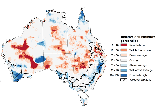
Lower layer soil moisture for August 2021 was above average for this time of year across parts of western, eastern and southern Australia, as well the far north. Lower layer soil moisture was below average to well below average across parts of central Australia, including central and western Queensland, and central parts of Western Australia.
In cropping regions, lower layer soil moisture was above average to well above average for parts of northern New South Wales, southern Queensland and southern Western Australia. Lower layer soil moisture was below average to well below average in cropping regions across parts of central and northern Queensland. Lower layer soil moisture will be important for winter crops as they enter flowering and grain filling over the coming months.
Modelled lower layer soil moisture for August 2021
Note: This map shows the levels of modelled lower layer soil moisture (10 to 100 centimetres) during May 2021. This map shows how modelled soil conditions during May 2021 compare with May conditions modelled over the reference period (1911 to 2016). Dark blue areas on the maps were much wetter in May 2021 than during the reference period. The dark red areas were much drier than during the reference period. The bulk of plant roots occur in the top 20 centimetres of the soil profile. The lower layer soil moisture is a larger, deeper store that is slower to respond to rainfall and tends to reflect accumulated rainfall events over longer time periods. Source: Bureau of Meteorology (Australian Water Resources Assessment Landscape model)
Rainfall forecast for the next eight days
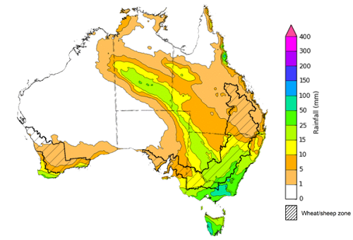
A trough of low-pressure systems is expected to track eastwards across Australia and is likely to result in rainfall across the south-east and parts of central Australia in the middle of the week. High pressure systems are anticipated to bring clear skies and dry conditions across much of Australia over the remainder of the week.
Rainfall totals of between 10 and 50 millimetres are forecast for much of New South Wales, Victoria and Tasmania, as well as isolated parts of western Queensland, eastern South Australia, south-west Western Australia and central areas of the Northern Territory. Rainfall in excess of 50 millimetres is expected in eastern Victoria and western Tasmania.
In Australian cropping regions, rainfall totals of between 10 and 50 millimetres are expected across much of New South Wales and Victoria. Little to no rainfall is forecast for cropping regions in Queensland, South Australia and Western Australia during the next 8-days.
The forecast rainfall for New South Wales and Victoria is likely to top up soil moisture levels and bolster yield potentials heading into spring. Above average soil moisture levels in southern Queensland, South Australia and Western Australia will support ongoing crop development, but further rainfall is required to realise strong yield prospects. The dry conditions in central Queensland will allow sowing of cotton to continue.
Total forecast rainfall (mm) for the period 2 September to 9 September 2021
©Commonwealth of Australia 2021, Australian Bureau of Meteorology - Issued: 2/09/2021
Water
Water storages, water markets and water allocations - current week
The Tableau dashboard may not meet accessibility requirements. For information about the contents of these dashboards contact ABARES.

