Key issues
- During the week ending 5 May 2021, fronts and troughs resulted in moderate rainfall being recorded across parts of western and south-eastern Australia, and isolated parts of northern Australia.
- The rainfall across cropping regions in New South Wales and Western Australia is likely to benefit the establishment of early sown winter crops and encourage addition planting activity. The dry conditions in some Queensland cropping regions have been ideal for late summer crop harvesting.
- Rainfall during April 2021 was below average across much of Australia. The early autumn break in March was not consolidated during April for large areas of New South Wales and Victoria. This dry period following the early autumn break increases the risk of plants experiencing moisture stress after germination. Much of southern Australia will rely on significant May rainfall to support winter crop establishment and pasture development.
- Over the next eight days, troughs and low-pressure systems are likely to bring showers and storms to parts of southern and eastern Australia, while high pressure systems are expected to keep the remainder of Australia dry.
- In Australia’s cropping regions, rainfall totals of between 5 and 15 millimetres are expected across much of Victoria and South Australia, and parts of eastern New South Wales and western and southern Western Australia over the next eight days. Little to no rainfall is expected across remaining cropping regions. These low rainfall totals are not likely to significantly benefit winter cropping regions, particularly in Victoria and South Australia where soil moisture is low.
- Water storage in the Murray–Darling Basin (MDB) decreased by 7 gigalitres (GL) between 28 April 2021 and 5 May 2021. The current volume of water held in storage is 13,955 GL, which represents 55% of total capacity. This is 51% or 4,719 GL more than at the same time last year.
- Allocation prices in the Victorian Murray below the Barmah Choke remained steady at $95 per ML on 29 April 2021 to 6 May 2021. Prices are lower in the Murrumbidgee due to binding of the Murrumbidgee export limit.
Climate
[expand all]
Rainfall this week
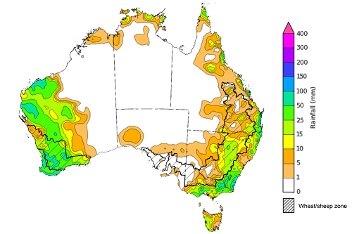
During the week ending 5 May 2021, fronts and troughs resulted in moderate rainfall being recorded across parts of western and south-eastern Australia, and isolated parts of northern Australia.
Rainfall totals of between 5 and 25 millimetres were recorded across much of New South Wales, Victoria and Tasmania, and parts of eastern Queensland, the western half of Western Australia and the north of the Northern Territory. Rainfall totals of between 25 and 100 millimetres were recorded across parts of eastern New South Wales, southern and eastern Victoria, the west of Western Australia and isolated parts of eastern Queensland.
In cropping regions, rainfall of between 5 and 25 millimetres was recorded across parts of central and northern New South Wales, southern and northern Queensland and eastern Victoria. Rainfall of between 15 and 100 millimetres was recorded across most Western Australian cropping regions. Little to no rainfall was recorded across cropping regions in southern New South Wales, western Victoria, the remainder of Queensland and South Australia.
The rainfall across cropping regions in New South Wales and Western Australia is likely to benefit the establishment for early sown winter crops and encourage addition planting activity. The dry conditions in some Queensland cropping regions have been ideal for late summer crop harvesting. However, as most cropping regions in Victoria and South Australia received low rainfall totals during March and April and have low soil moisture levels, these regions will particularly rely on May rainfall to support winter crop germination and establishment.
Rainfall for the week ending 5 April 2021
©Commonwealth of Australia 2021, Australian Bureau of Meteorology - Issued: 05/05/2021
Note: The rainfall analyses and associated maps utilise data contained in the Bureau of Meteorology climate database, the Australian Data Archive for Meteorology (ADAM). The analyses are initially produced automatically from real-time data with limited quality control. They are intended to provide a general overview of rainfall across Australia as quickly as possible after the observations are received. For further information go to http://www.bom.gov.au/climate/rainfall/
Monthly temperatures
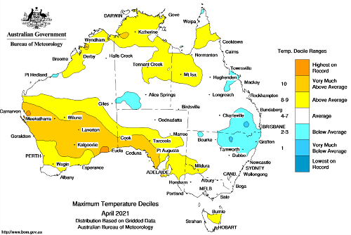
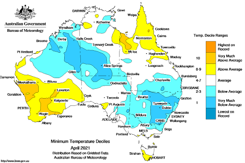
April 2021 was warmer than average nationally with a national mean temperature of 0.21°C above average, a mean maximum temperature of 0.85°C above average and a mean minimum temperature of 0.43°C below average.
Maximum temperatures for April were above average to very much above average across large parts of south-western Australia and parts of northern Australia. Similarly, minimum temperatures were above average to very much above average across parts of south-western and north-eastern Australia. Maximum temperatures were below average across parts of eastern Australia and minimum temperatures were below average across large parts of south-eastern, central and north-western Australia. Across cropping regions in northern New South Wales and southern Queensland, below average temperatures coupled with low rainfall and low soil moisture levels are likely to have slowed the development of early sown winter crops and the growth rate of pastures.
Maximum temperature deciles for April 2021
©Commonwealth of Australia 2021, Australian Bureau of Meteorology Issued: 01/05/2021
Minimum temperature deciles for April 2021
©Commonwealth of Australia 2021, Australian Bureau of Meteorology Issued: 01/05/2021
Monthly rainfall
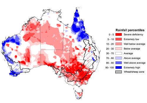
Rainfall during April 2021 was below average for much of Australia. Rainfall was well above average to extremely high across parts of northern Queensland and the west of Western Australia. Rainfall was extremely low to well below average across much of New South Wales, Victoria, South Australia, eastern Western Australia, the Northern Territory and parts of south-western Queensland and north-eastern Tasmania.
The El Niño–Southern Oscillation (ENSO) was neutral during April and the influence of the recent La Niña event on Australia’s climate diminished. The Madden–Julian Oscillation (MJO) had the strongest influence on Australia’s climate during April. For the first half of the month the MJO resulted in above average rainfall across northern Australia and at the end of the month it slightly suppressed rainfall across northern Australia. In April tropical cyclones and low-pressure troughs generated heavy rainfall and thunderstorms in parts of eastern, western and northern Australia.
April rainfall was severely deficient to below average for most of the cropping regions in central and southern New South Wales, Victoria and South Australia. Rainfall was above average to extremely high for parts of the cropping regions in Western Australia and generally average across remaining cropping regions in New South Wales, Queensland and Western Australia.
The early autumn break in March was not consolidated during April for large areas of New South Wales and Victoria. This dry period following the early autumn break increased the risk of plants experiencing moisture stress after germination, with a disconnect emerging between upper- and lower-layer soil moisture. Much of southern Australia will rely on significant May rainfall to support winter crop establishment and pasture development.
Rainfall percentiles for April 2021
Source: Bureau of Meteorology
Note: Rainfall for April 2021 is compared with rainfall recorded for that period during the historical record (1900 to present). For further information, go to http://www.bom.gov.au/water/
Monthly soil moisture
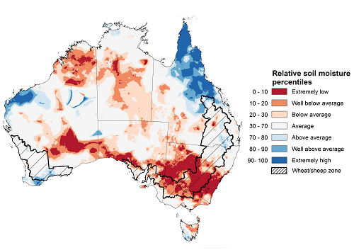
Upper layer soil moisture in April 2021 was extremely low to below average for this time of year across large parts of southern, central, and north-eastern Australia, reflecting rainfall patterns during the month. However, modelled upper layer soil moisture was above average to extremely high across parts of northern Queensland and the west of Western Australia. Upper layer soil moisture is important at the beginning of the winter cropping season since plant germination and establishment utilise this moisture.
Upper layer soil moisture was extremely low to below average for this time of year across most cropping regions in New South Wales, Victoria and South Australia. Soil moisture was average across most cropping regions in northern New South Wales, Queensland and Western Australia.
Modelled upper layer soil moisture for April 2021
Source: Bureau of Meteorology (Australian Water Resources Assessment Landscape model)
Note: This map shows the levels of modelled upper layer soil moisture (0 to 10 centimetres) during April 2021. This map shows how modelled soil conditions during April 2021 compare with April conditions modelled over the reference period (1911 to 2016). Dark blue areas on the maps were much wetter in April 2021 than during the reference period. The dark red areas were much drier than during the reference period. The bulk of plant roots occur in the top 20 centimetres of the soil profile. Soil moisture in the upper layer of the soil profile is therefore useful indicator of the availability of water, particularly for germinating seed.
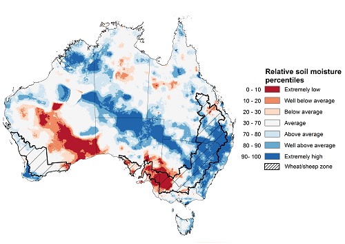
Lower layer soil moisture for April 2021 was above average to extremely high for this time of year across large parts of south-eastern, central and north-western Australia, and scattered parts of western and north-eastern Australia. Lower layer soil moisture was extremely low to below average across parts of central and southern Western Australia, south-eastern Australia and isolated parts of northern Australia.
In cropping regions, lower layer soil moisture was above average to extremely high for much of New South Wales and Queensland. Lower layer soil moisture was extremely low to below average in cropping regions across parts of western Victoria and South Australia. Soil moisture was average across most cropping regions in Western Australia.
As the early autumn break was not consolidated during April for large areas of southern New South Wales and Victoria, there is a disconnect emerging between upper and lower layer soil moisture. While there is average or better lower layer soil moisture across many cropping regions, recently planted crops require upper layer soil moisture to germinate and become established. Where low levels of upper layer soil moisture remain over a sustained period the risk of plant death is increased. In annual pasture situations this can result in a reduced seed bank left available for the winter growing season and lowering potential production, while in cropping situations this may require reseeding of winter crops.
Modelled lower layer soil moisture for April 2021
Source: Bureau of Meteorology (Australian Water Resources Assessment Landscape model)
Note: This map shows the levels of modelled lower layer soil moisture (10 to 100 centimetres) during April 2021. This map shows how modelled soil conditions during April 2021 compare with April conditions modelled over the reference period (1911 to 2016). Dark blue areas on the maps were much wetter in April 2021 than during the reference period. The dark red areas were much drier than during the reference period. The bulk of plant roots occur in the top 20 centimetres of the soil profile. The lower layer soil moisture is a larger, deeper store that is slower to respond to rainfall and tends to reflect accumulated rainfall events over longer time periods.
Rainfall forecast for the next eight days
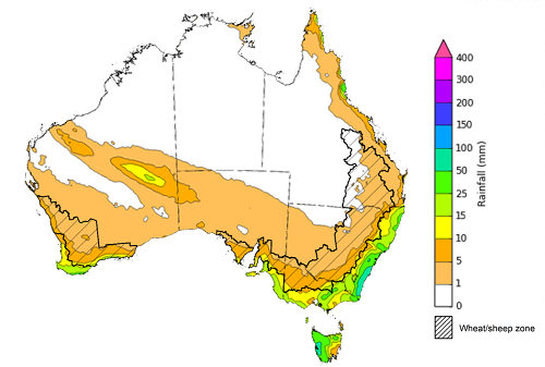
Troughs and low-pressure systems are likely to bring showers and storms to isolated parts of southern and eastern Australia during the 8 days to 13 May 2021, while high-pressure systems are expected to keep the remainder of Australia dry.
Rainfall totals of between 10 and 50 millimetres are forecast for parts of eastern New South Wales, southern Victoria, south-eastern South Australia, south-western and central Western Australia, Tasmania and isolated parts of north-eastern Queensland. Rainfall totals in excess of 50 millimetres are forecast for isolated parts of south-eastern New South Wales and western Tasmania.
In Australia’s cropping regions, rainfall totals of between 5 and 15 millimetres are expected across much of Victoria and South Australia, and parts of eastern New South Wales and western and southern Western Australia. Little to no rainfall is expected across remaining cropping regions. These low rainfall totals are not likely to significantly benefit winter cropping regions, particularly in Victoria and South Australia where soil moisture is low.
Total forecast rainfall (mm) for the period 6 May to 13 May 2021
©Commonwealth of Australia 2021, Australian Bureau of Meteorology - Issued: 06/04/2021
Note: This rainfall forecast is produced from computer models. As the model outputs are not altered by weather forecasters, it is important to check local forecasts and warnings issued by the Bureau of Meteorology.
Water
Water storages, water markets and water allocations - current week
The Tableau dashboard may not meet accessibility requirements. For information about the contents of these dashboards contact ABARES.
Commodities
Information on weekly price changes in agricultural commodities is now available at the Weekly commodity price update.

