
Key issues
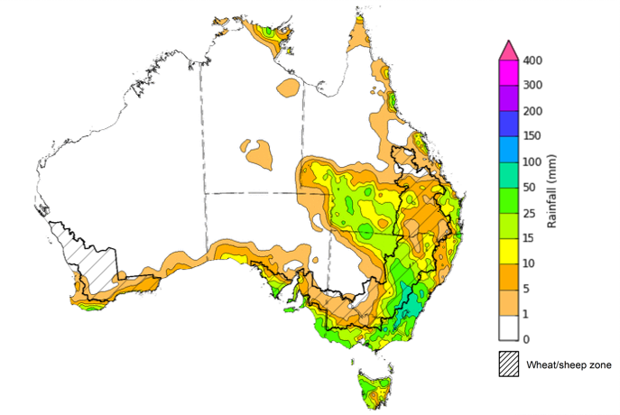
- For the week ending 3 May 2023, high pressure systems brought clear and dry conditions to much of the country. However, a frontal system moved across the far south of South Australia and Victoria delivering up to 50 millimetres of rain. Meanwhile, a surface low pressure system brought heavy falls in the Hunter, Illawarra and southern Tableland districts in New South Wales and in southern Queensland, with up to 100 millimetres recorded in some parts.
- In cropping regions, rainfall of up to 100 millimetres was recorded across central New South Wales, with totals up to 25 millimetres in isolated areas of western Queensland, northern New South Wales, eastern Victoria and parts of central and western South Australia. Little to no rainfall was recorded across the remaining cropping regions. Harvesting of summer crops would have continued with mainly clear, dry conditions over the past week (see Section 1.1).
- Above average rainfall during April has consolidated the early autumn break recorded across much of New South Wales and eastern Victoria, parts of southern Queensland, northern Tasmania, and southwest Western Australia. A consolidated early autumn break can increase the length of the growing season, potentially improving production and yield. In South Australia, the early autumn break was consolidated in only a small area in the southeast (see Section 1.3).
- For the 3 months to April 2023, above average to extremely high pasture production for this time of year was observed across much of central Western Australia, Northern Territory and Queensland, as well in the southern New South Wales, and isolated parts of South Australia. Extremely low to below average pasture growth rates were recorded across southern and northern Western Australia, southern Victoria, much of northern and eastern New South Wales, southeast and northern Queensland, and the north of the Northern Territory, consistent with above average temperatures and/or below average rainfall (see Section 1.5)
- Over the 8-days to 4 May 2023, a series of colds front are expected to move across south-eastern states that will trigger cold temperatures over southern parts of Australia and showers in southern Victoria, south-eastern South Australia and in western Tasmania. A trough is expected to bring showers in southwestern Western Australia. A weak trough will generate showers in the far northern tropics. A high-pressure system will keep much of the remainder of Australia clear and dry (see Section 1.6).
- Across Australian cropping regions, rainfall totals of up to 50 millimetres are expected for Western Australia. Little to no rainfall is expected for the remaining cropping regions in the next eight days. Across eastern Australia the dry conditions may help wrap up the harvesting of sorghum and cotton, and the planting of winter crops, while wet conditions in western Australia may delay planting progress (see Section 1.6).
- Water storage levels in the Murray-Darling Basin (MDB) increased between 27 April 2023 and 4 May 2023 by 352 gigalitres (GL). Current volume of water held in storage is 20 081 GL. This is 1 percent or 211 GL more than at the same time last year.
- Allocation prices in the Victorian Murray below the Barmah Choke increased from $10 on 27 April 2023 to $11 on 4 May 2023.
Climate
For the week ending 3 May 2023, high pressure systems brought clear and dry conditions to much of the country. However, a frontal system moved across the far south of South Australia and Victoria delivering up to 50 millimetres of rain. Meanwhile, surface low pressure system brought heavy falls in the Hunter, Illawarra and southern Tableland districts in New South Wales and in the southern Queensland, with up to 100 millimetres recorded in some areas.
In the cropping regions, rainfall of up to 100 millimetres was recorded across central New South Wales, with totals up to 25 millimetres in isolated areas of western Queensland, northern New South Wales, eastern Victoria and parts of central and western South Australia. Little to no rainfall was recorded across the remaining cropping regions. Harvesting of summer crops would have continued with mainly clear, dry conditions over the past week. Rainfall in New South Wales will have allowed build-up of soil moisture for the winter cropping season.
Rainfall for the week ending 3 May 2023
Note: The rainfall analyses and associated maps utilise data contained in the Bureau of Meteorology climate database, the Australian Data Archive for Meteorology (ADAM). The analyses are initially produced automatically from real-time data with limited quality control. They are intended to provide a general overview of rainfall across Australia as quickly as possible after the observations are received. For further information go to http://www.bom.gov.au/climate/rainfall/
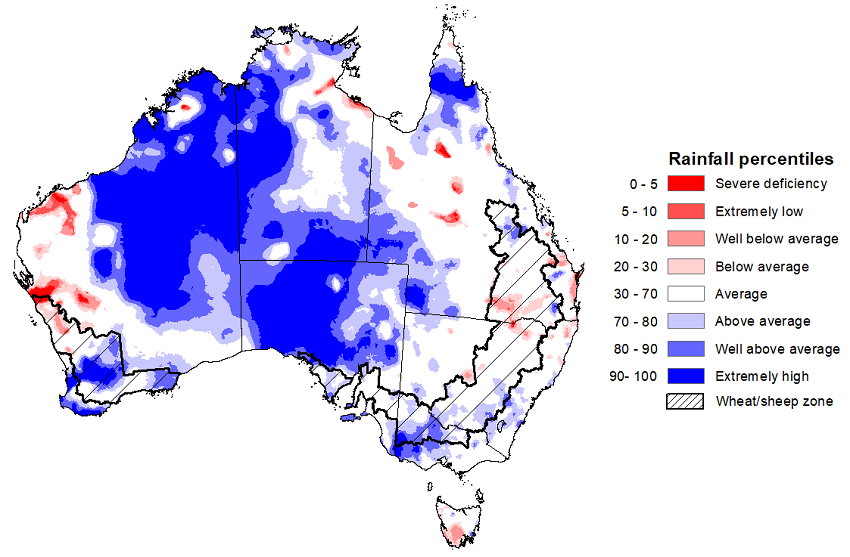
Rainfall during April 2023 was above average for Australia, and the highest April rainfall total since 2006. Rainfall was above average for most of Western Australia, the Northern Territory, South Australia, much of Queensland’s southwest and Cape York Peninsula, parts of southern New South Wales and most of central and western Victoria. Rainfall was below average for scattered areas in south-eastern Queensland and northern New South Wales, parts of Western Australia’s Gascoyne and central west, and southern Tasmania. The main drivers for April rainfall were a series of troughs, lows, frontal systems and Tropical Cyclone Ilsa.
In the cropping regions, April rainfall was above average across central and southeast Western Australia, parts of northern and eastern Queensland, southern New South Wales, western South Australia and much of Victoria. Below average rainfall was recorded in southern Queensland, northern parts of New South Wales and northern Western Australia. Average rainfall was recorded in the remaining cropping regions.
Rainfall percentiles for April 2023
An early autumn break was achieved in March 2023 across cropping regions of northern, eastern and southern New South Wales, southern Queensland, parts of central and eastern Victoria, northern Tasmania and large areas of central Western Australia (refer to the weekly climate update report dated 30 March 2023).
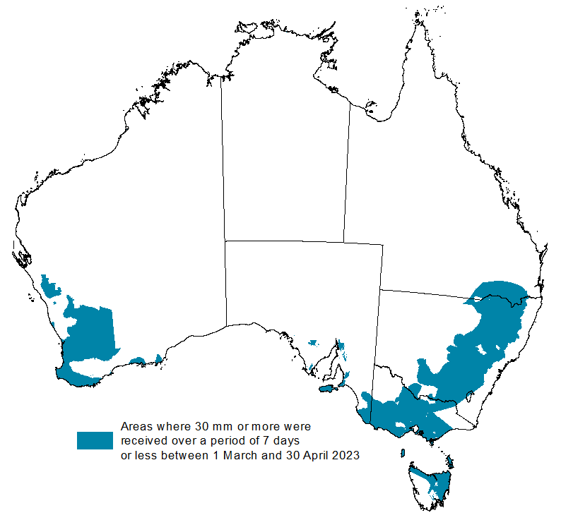
An early autumn break can increase the length of the growing season, potentially improving production and yield. The definition of the autumn break in southern Australia varies. Pook et al. (2009) suggested an ideal break for north-western Victoria occurs during March–June when a mean fall of 25 millimetres or more is recorded over a period of 3 days or less, or when a mean fall of 30 millimetres or more is recorded over a period of 7 days or less.
ABARES has adapted the Pook et al. (2009) autumn break definition of falls of 30 millimetres or more recorded within any 7-day period from 1 March to 30 April to identify where the autumn break threshold has been achieved across southern Australia.
ABARES analysis of daily rainfall data sourced from the Bureau of Meteorology indicates that the autumn break has been achieved across much of the cropping regions in New South Wales, Victoria and Western Australia, southern Queensland and isolated parts of South Australia. An autumn break has not been achieved in the northern Queensland and Victoria, isolated parts of central and southern New South Wales, much of South Australia and across parts of northern and eastern Western Australia.
Typically, the autumn break is driven by westerly fronts moving across southern Australia and cut-off low pressure systems. However, the consolidated autumn break in March to April 2023 has been driven by a number of lows and frontal systems, as well as the formation of rainbands associated with the decay of severe Tropical Cyclone Ilsa that extended from northwest to southeast of the country.
Southern pasture and cropping areas that have achieved 30 millimetres in any 7‐day period in March – April, 2023
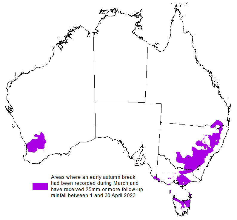
It is important to remember that while the timing of the rain is important, as to whether it constitutes a break or not, it is the weather following this early break that will determine whether this is a ‘false’ break or a true early break. For example, a 30mm rainfall event in March followed by warm, dry weather may not constitute the break. However, if a similar rainfall event were to occur during April, it will likely be the break that many southern farmers have been waiting for. An early autumn break in and of itself does not guarantee a successful growing season; sufficient winter and spring rainfall is still required, particularly in areas with little to no stored soil moisture, to deliver a successful crop and pasture production season.
Rainfall during April has consolidated the early autumn break recorded across much of New South Wales and eastern Victoria, southern part of Queensland, northern Tasmania, and southwest Western Australia. These falls have continued to improve soil moisture profiles and allowed for an ideal start to winter crop planting and autumn pasture growth in these areas. A consolidated early autumn break can increase the length of the growing season, potentially improving production and yield. In South Australia, the early autumn break was consolidated in only a small area in the southeast. This dry period following the early autumn break increases the risk of plants experiencing moisture stress after germination, with a disconnect emerging between upper- and lower-layer soil moisture.
Areas that have received at least 25 millimetres of follow-up rainfall from 1 to 30 April 2023
Note: The autumn break generally applies to the southern pasture and cropping areas mainly in New South Wales, Victoria, South Australia, Western Australia and Tasmania — and occasionally parts of southern Queensland. Areas that are not typically influenced by the autumn break have been shaded out.
Upper layer soil moisture in April 2023 was average to very much above average for this time of year across much of the country. Extremely high upper layer soil moisture was evident across large areas in Western Australia, Northern Territory, South Australia, Victoria, southern New South Wales, southwest, as well as in the north-eastern Tasmania. Below average upper layer soil moisture was evident in parts of central, Cape York Peninsula and south-eastern Queensland, parts of northern New South Wales, southern Tasmania, western South Australia, and western and southeast Western Australia.
At this time of year, upper layer soil moisture is important for the germination and establishment of early sown winter crops across Australian cropping regions. It is also important indicator of the ability to access paddocks to undertake harvesting of summer crops in New South Wales and Queensland, as well as planting activities for winter crops.
In the cropping regions, upper layer soil moisture was above average in northern and parts of southeast Queensland, southern New South Wales, much of Victoria and South Australia, and much of southern Western Australia. Below average upper later soil moisture was evident in southwest Queensland, northwest New South Wales and Western Australia. Upper layer soil moisture was average across remaining cropping regions. The above average to average upper layer soil moisture in parts of northern Queensland is likely to have prevented field access for summer crop harvesting and field preparation for winter crop sowing. The above average upper layer soil moisture levels across most cropping regions will support winter crops through germination and establishment of early sown winter crop but prevented some field access for follow up winter crop planting.
Modelled upper layer soil moisture for April 2023
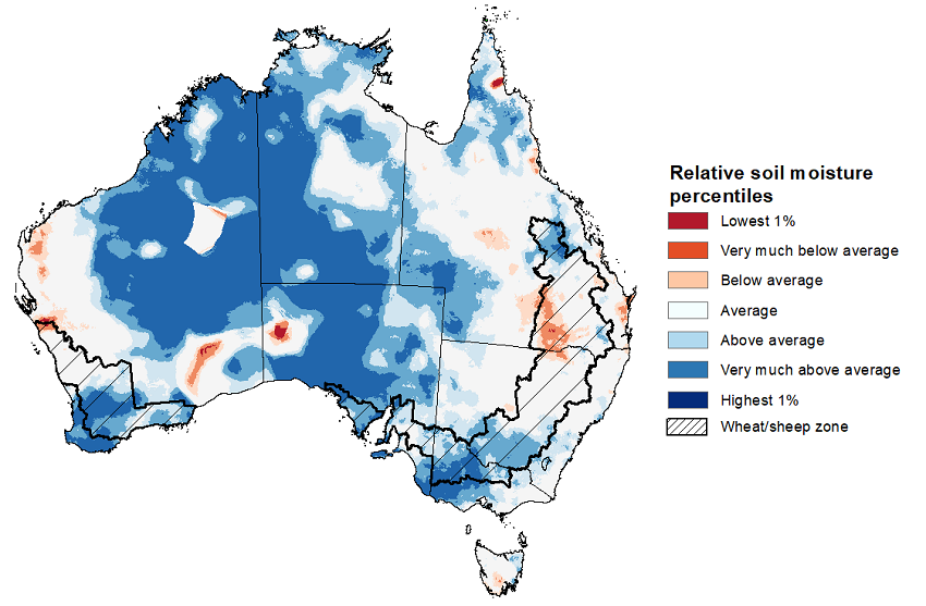
Source: Bureau of Meteorology (Australian Water Resources Assessment Landscape model
Lower layer soil moisture for April 2023 was average to above average across much of Australia, with an exception in across large areas of northeast and southern Queensland, central north and coastal New South Wales, isolated parts in the southeast Western Australia and western South Australia, as well as in the western Tasmania where it was extremely low.
Lower layer soil moisture is a larger, deeper store that is slower to respond to seasonal conditions and tends to reflect the accumulated effects of events that have occurred over longer periods. Crop development and pasture growth in areas of above average lower layer soil moisture are typically less reliant on in-season rainfall than in areas with below average lower layer soil moisture.
In cropping regions, lower layer soil moisture was generally average to extremely high in Western Australia, South Australia, Victoria and across southern and northeast New South Wales, and in the southeast Queensland. However, it was extremely low to below average in western Queensland and northwest New South Wales. April rainfall has generally benefitted lower layer soil moisture levels across most growing regions, which is likely to provide an increased confidence to plant longer season winter crops. Areas with below average levels of lower layer soil moisture will be highly dependent on timely and sufficient in-season rainfall to support average winter crop production prospects.
Modelled lower layer soil moisture for April 2023
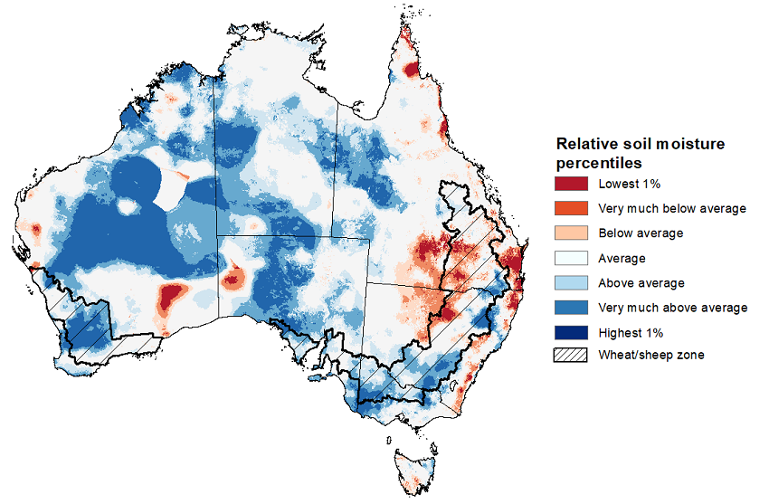
Source: Bureau of Meteorology (Australian Water Resources Assessment Landscape model)
February to April forms the final 3-months of the pasture growing season across much of northern Australia, providing a late season boost in growth and the bulk of feed to maintain production through the low pasture growth months of the northern dry season. Pasture availability during this period influences the growth and branding and marking rates of lambs and calves, livestock turnoff and the production of meat, milk, and wool.
For the 3 months to April 2023, above average rainfall totals and below average summer temperatures resulted in above average to extremely high pasture production for this time of year across much of central Western Australia, Northern Territory and Queensland, as well in the southern New South Wales, isolated parts of South Australia, and central and eastern Victoria. Extremely low to below average pasture growth rates were recorded across parts of southern and northern Western Australia, southern Victoria, much of northern and eastern New South Wales, southeast and northern Queensland, and the north of the Northern Territory, consistent with above average temperatures and/or below average rainfall.
Average to extremely high pasture production across grazing regions will likely enable farmers to continue to rebuild stock numbers and provide opportunities to build standing dry matter availability. Below average temperatures and a lack of rainfall across northern New South Wales and south-eastern Queensland may have restricted summer pasture growth. However, it comes after extremely high pasture growth during winter and spring that supplied average to above average pasture availability and ample opportunities to conserve excess fodder.
Relative pasture growth for 3-months ending April 2023 (1 February 2023 to 30 April 2023)
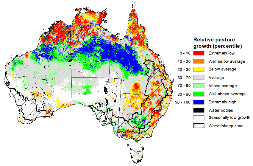
Source: Queensland Department of Science, Information Technology, and Innovation
Over the 8-days to 4 May 2023, a series of colds front are expected to move across south-eastern states that will trigger cold temperatures over southern parts of Australia and showers in southern Victoria, south-eastern South Australia and in western Tasmania. A trough is expected to bring showers and storms in southwestern Western Australia. A weak trough will generate showers in the far northern tropics. The high-pressure system will keep much of the remainder of Australia clear and dry.
Across Australian cropping regions, rainfall totals of up to 50 millimetres are expected for Western Australia. Little to no rainfall is expected for the remaining cropping regions in the next eight days. Dry conditions may help wrap up the harvesting of sorghum and cotton. The dry conditions expected across southern New South Wales cropping regions will allow the harvesting of cotton and rice to continue, as well as the planting of winter crops. Dry conditions in the east will encourage increased planting activity over the coming week while increased in the west may delay planting progress. Many growers will be eager to complete planting programs as soon as possible given the given average to above average moisture soil levels across many growing regions.
Much of South Australia is still yet to receive a typical autumn break¬ (falls of 30 millimetres or more recorded within any 7-day period from 1 March to 30 April). Despite this lack of a typical autumn break¬, numerous lower rainfall total events have slowly built up the soil moisture store, giving growers increased confidence to continue to plant winter crops given above average soil moisture levels in many regions.
Total forecast rainfall for the period 27 April to 4 May 2023
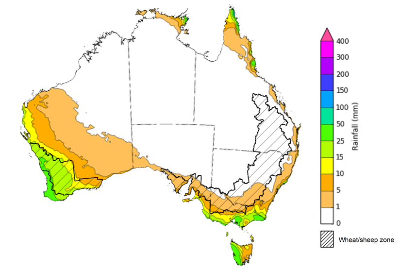
Note: This rainfall forecast is produced from computer models. As the model outputs are not altered by weather forecasters, it is important to check local forecasts and warnings issued by the Bureau of Meteorology
Water
Water storages, water markets and water allocations - current week
The Tableau dashboard may not meet accessibility requirements. For information about the contents of these dashboards contact ABARES.

Commodities
Information on weekly price changes in agricultural commodities is now available at the Weekly commodity price update.