
Current National Occurrence of Feral Deer in Australia (2026) is a collection of continental spatial datasets of the gridded current known occurrence of feral deer in Australia. It contains maps of the known occurrence of each species of deer in Australia: chital deer (Axis axis), hog deer (Axis porcinus), fallow deer (Dama dama), red deer (Cervus elaphus), rusa deer (Cervus timorensis) and sambar deer (Cervus unicolor), and the combined known occurrence of all deer in Australia. The maps were created by collating verified data from jurisdictional agencies and other data sources using a national grid.
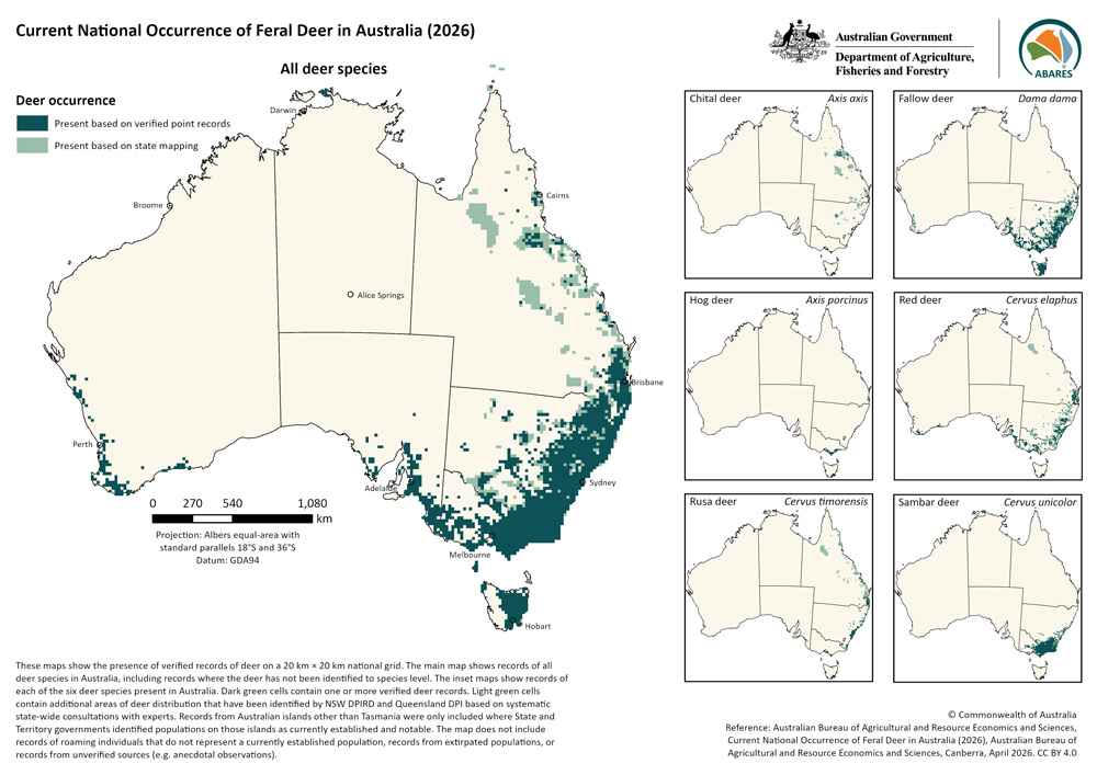
This dataset has been created using two types of occurrence data that have been aggregated using a 20 km × 20 km national grid. These data were collated from Australian, state and territory government agencies and other sources ranging from research institutions to citizen science platforms. A full list of data sources is provided in the metadata.
The primary data type is deer occurrence point records that have been collated by ABARES and verified by relevant experts. Cells that contain verified deer occurrence point records are shown in dark green on the national maps. The second data type is jurisdictional expert opinion data on deer distribution produced by systematic state-wide expert opinion mapping programs. Cells which do not contain verified deer occurrence point records but do overlap with areas of deer distribution mapped by jurisdictional expert opinion mapping programs are shown in light green on the national maps. A more detailed description of the collation and processing of different data types is provided in the metadata document.
This dataset covers mainland Australia and Tasmania. Records from other Australian islands were only included where state and territory governments identified populations on those islands as currently established and notable.
This dataset should be used as a broad-scale indication of deer occurrence in Australia. It is indicative only and should not be used to plan local-scale control or monitoring efforts. Deer records have been aggregated to a coarse 20 km × 20 km grid and do not reflect patterns of distribution at finer scales. Aggregation will produce a slight overrepresentation of extent in areas where the true boundary of the distribution falls within a cell.
While every effort has been made to ensure that the dataset is correct at the time of publication, it is unlikely to accurately reflect the current distribution of feral deer where recent lethal suppression efforts, eradication programs, range expansions, or accidental or illegal releases have taken place, as the data available for mapping inherently lag the true distribution of the species. In particular, the South Australian government is currently conducting a state-wide deer eradication program which aims for population reductions followed by total eradication by 2032.
Hybridisation between deer species can pose a problem for the accuracy of distribution maps for individual species. While no records from individuals that were known hybrids were included in the species-level datasets, animals are often identified to species based on morphological characteristics, which can be highly variable in hybrid animals. Thus, it is possible that some hybrid individuals may have been included in these datasets for particular species. For example, some hybrid rusa-sambar individuals may have been included in the maps for either rusa deer (Cervus timorensis) or sambar deer (Cervus unicolor) in regions where the species overlap. Genetic data suggests that all of Victoria’s hog deer (Axis porcinus) population have hybrid origins with chital deer (Axis axis). However, as this hybridisation was historical and is not ongoing in Victoria, individuals have simply been mapped as hog deer in this dataset.
More information and updates about the occurrence and abundance of feral deer can also be obtained from state and territory government primary industries and environment departments. Recent work from the Arthur Rylah institute has modelled the distribution and abundance on public lands of the four main deer species (fallow, red, sambar and hog deer) which occur in Victoria. The NSW and Queensland governments regularly produce maps of deer species in their states based on consultation with land and pest management organisations (DPIRD NSW distribution maps for vertebrate pests and DPI Qld annual pest distribution survey). Although these datasets have been incorporated as expert opinion data into this dataset, the original mapping for both programs is at a higher resolution and contains further information about abundance.
This dataset is a product of the National Vertebrate Pests and Weeds Distribution project.
This dataset gives an overview of the occurrence of the six species of deer in Australia. More detailed datasets are available for fallow deer and sambar deer which give the current relative abundance: Current National Relative Abundance of Fallow Deer in Australia (2026) dataset and the Current National Relative Abundance of Sambar Deer in Australia (2026) dataset.
This dataset was produced from a collaboration between the Australian Bureau of Agricultural and Resource Economics and Sciences (ABARES) and data contributors, as part of the National Vertebrate Pests and Weeds Distribution Project. Guidance for this project was provided by a steering committee comprising representatives from environment and primary industries agencies from all states and territories. The project was supported with funding from the Australian Government Department of Agriculture, Fisheries and Forestry’s Established Pest Animals and Weeds Management Pipeline Program and Supporting Communities Manage Pest Animals and Weeds Program.
Current National Occurrence of Feral Deer in Australia (2026)
- Current National Occurrence of Feral Deer in Australia (2026) Metadata (PDF 590 KB)
- Current National Occurrence of Feral Deer in Australia (2026) Metadata (Word 800 KB)
- Current National Occurrence of Feral Deer in Australia (2026) Spatial Dataset (ZIP 550KB)
Image files (PNG) of Current National Occurrence of Feral Deer in Australia (2026) maps:
- Current National Occurrence of Chital Deer (Axis axis) in Australia (2026) Map (PNG 570 KB)
- Current National Occurrence of Hog Deer (Axis porcinus) in Australia (2026) Map (PNG 520 KB)
- Current National Occurrence of Fallow Deer (Dama dama) in Australia (2026) Map (PNG 570 KB)
- Current National Occurrence of Red Deer (Cervus elaphus) in Australia (2026) Map (PNG 570 KB)
- Current National Occurrence of Rusa Deer (Cervus timorensis) in Australia (2026) Map (PNG 570 KB)
- Current National Occurrence of Sambar Deer (Cervus unicolor) in Australia (2026) Map (PNG 570 KB)
- Current National Occurrence of Feral Deer in Australia (2026) Map (PNG 580 KB)
- Current National Occurrence of Feral Deer in Australia (2026) Combined Map (PNG 640 KB)
If you have difficulty accessing these files, contact us for help.
Australian Bureau of Agricultural and Resource Economics and Sciences 2026, Current National Occurrence of Feral Deer in Australia (2026), Australian Bureau of Agricultural and Resource Economics and Sciences, Canberra, April, https://doi.org/10.25814/bzzm-tt25. CC BY 4.0.