
- For the week ending 1 December 2021, low-pressure troughs stretching across northern and eastern Australia resulted in significant rainfall, especially in the eastern states. However, blocking high pressure systems to the south of Australia brought clear, dry conditions to western parts of the country over the last 7-days.
- Rainfall during November 2021 was extremely high across much of Australia, with scattered areas of below average to average rainfall across parts of northern, western and southern Australia. A La Niña event became established in the Pacific Ocean in November, while the Indian Ocean Dipole (IOD) weakened and returned to neutral values. Meanwhile, the Southern Annular Mode (SAM) fluctuated between neutral and positive values.
- November 2021 has been the wettest November on record for the New South Wales and Queensland wheat sheep zone, with many locations recorded rainfall totals 3 times higher than average for November. This has caused flooding in northern and central western regions of New South Wales and across south-east Queensland, resulting in grain production losses for producers in the worst affected areas. It is too early to say what the full impact of flooding in parts of New South Wales and Queensland will be on agricultural producers and communities. Many farmers are still surveying the damage, with limited ability to undertake detailed assessments at this stage.
- Over the 8-days to 9 December 2021 high pressure systems over the Great Australian Bight will bring clear, dry conditions to much of western and southern Australia. Meanwhile, a trough of low-pressure systems is expected to dominate eastern and northern Australia, drawing down moist, tropical air and resulting in storms and substantial rainfall over the next 8-days.
- The rainfall expected across New South Wales and Queensland follows extremely high rainfalls in November and already saturated soil profiles. Continued flooding across multiple catchments is expected, and the wet conditions have the potential to adversely affect mature winter crops due to lodging, grain sprouting and fungal staining issues. Harvesting of winter crops and planting of summer crops are likely to be further delayed.
- Water storage in the Murray–Darling Basin (MDB) increased by 218 gigalitres (GL) between 24 November 2021 and 1 December 2021. The current volume of water held in storage is 22,752 GL, which represents 90% of total capacity. This is 48% or 7,428 GL more than at the same time last year.
- Allocation prices in the Victorian Murray below the Barmah Choke decreased from $98 per ML on 19 November 2021 to $93 per ML on 26 November 2021. Prices are lower in the Goulburn-Broken, Murrumbidgee, and regions above the Barmah Choke due to the binding of the Goulburn intervalley trade limit, Murrumbidgee export limit, and Barmah Choke trade constraint.
Climate
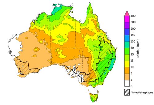
For the week ending 1 December 2021, low-pressure troughs stretching across northern and eastern Australia resulted in significant rainfall, especially in the eastern states. However, blocking high pressure systems to the south of Australia brought clear, dry conditions to western parts of the country over the last 7-days.
Rainfall totals of between 10 and 100 millimetres were recorded across much of New South Wales, eastern and northern Queensland, eastern Victoria and eastern South Australia, as well as the far north of Western Australia and the Northern Territory. Rainfall totals in excess of 100 millimetres were recorded across isolated parts of New South Wales and eastern Queensland. Meanwhile, much of Western Australia receive little to no rainfall.
In cropping regions, rainfall totals of between 10 and 100 millimetres were recorded across New South Wales and Queensland, as well as parts of western Victoria. Little to no rainfall was recorded across remaining cropping regions of Victoria, South Australia and Western Australia. Relatively dry conditions across cropping regions of Victoria, South Australia and Western Australia would have supported the maturing and harvesting of winter crops.
The continuation of substantial rainfall across New South Wales and Queensland has led to significant flooding events in multiple catchments. The wet conditions have not only put harvesting activities on hold but pose a risk to crop yields and quality. The wet conditions will also have stalled summer planting activity, and negatively impacted the germination and establishment of crops.
Rainfall for the week ending 1 December 2021
Note: The rainfall analyses and associated maps utilise data contained in the Bureau of Meteorology climate database, the Australian Data Archive for Meteorology (ADAM). The analyses are initially produced automatically from real-time data with limited quality control. They are intended to provide a general overview of rainfall across Australia as quickly as possible after the observations are received. For further information go to http://www.bom.gov.au/climate/rainfall/
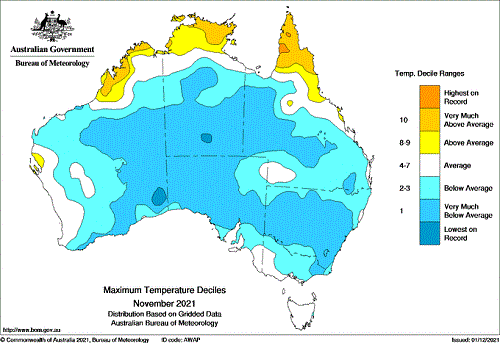
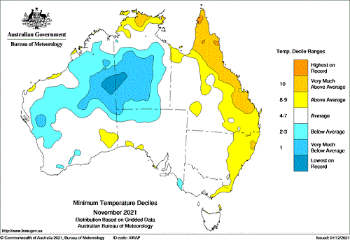
The national mean temperature for November 2021 was 0.63°C below the long-term average. The mean maximum temperature was 1.22°C below average, and the mean minimum temperature was 0.06°C below average.
Maximum temperatures for November were below average to very much below average across much of Australia. However, parts of far northern Australia recorded above average to very much above average maximum temperatures. Minimum temperatures were above average to very much above average across eastern parts of Australia and isolated parts of far northern Australia. Minimum temperatures were below average to very much below average in parts of central and western Australia. Below average temperatures may have improved yield potentials from some late sown winter crops but are reported to have negatively impacted the germination of summer crops throughout November.
Maximum temperature deciles for November 2021
Minimum temperature deciles for November 2021
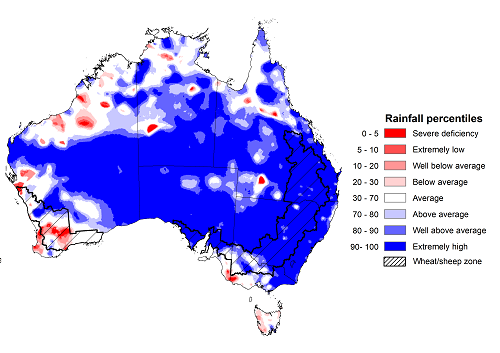
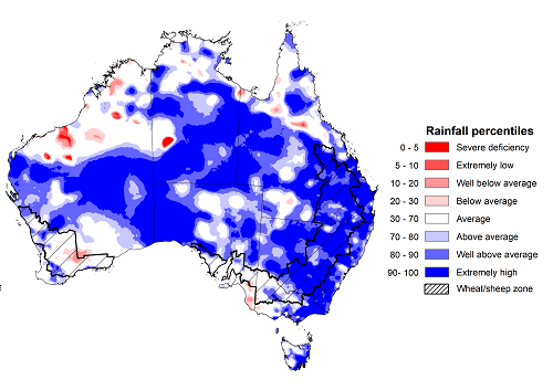
Rainfall during November 2021 was extremely high across much of Australia. However, scattered areas of below average to average rainfall were recorded across parts of northern, western and southern Australia. Rainfall was extremely high throughout New South Wales, southern and central Queensland, eastern Victoria, most of South Australia, eastern and central parts of Western Australia and the south of the Northern Territory. New South Wales and South Australia recorded their wettest November on record. Rainfall was below average to average in northern Queensland, western Victoria, the south-east of South Australia, the south-west and north of Western Australia, the north of the Northern Territory and Tasmania.
A La Niña event became established in the Pacific Ocean in November, while the Indian Ocean Dipole (IOD) weakened and returned to neutral values. Meanwhile, the Southern Annular Mode (SAM) fluctuated between neutral and positive values. The combination of a La Niña event, residual negative IOD patterns and a positive SAM contributed to the significant rainfall across the country in November. The combination of climate drivers was enhanced by an active Madden-Julian Oscillation in mid-November, with the built-up tropical moisture drawn down over Australia by low pressure systems.
November rainfall was extremely high across cropping regions of New South Wales, Queensland, central Victoria, the west of South Australia and parts of the north of Western Australia. Rainfall was below average to average in remaining parts of Victoria, South Australia and Western Australian cropping regions.
The extremely high rainfall in November has negatively impacted winter crops across New South Wales, as harvesting got underway in northern and central parts of the state. The rainfall is also likely to have negatively affected the germination of summer crops and reduced nutrient availability.
Rainfall percentiles for November 2021
Spring 2021 rainfall was 57% above the national long-term average and the highest spring rainfall total since 2010, with the build-up of a La Niña event and a negative Indian Ocean Dipole (IOD) influencing Australia’s climate. Rainfall was above average to extremely high much of New South Wales, southern and central Queensland, eastern Victoria, the west and east of South Australia, eastern and central parts of Western Australia, the south of the Northern Territory and eastern Tasmania.
The season began with above average or better rainfall across most cropping regions in New South Wales, southern Queensland and eastern and central Victoria in September. Meanwhile, cropping regions of South Australia and Western Australia received well below average to average rainfall. The wet conditions across eastern states eased in October with below average to average rainfall for most cropping regions, although Western Australia saw average to very much above average rainfall. November saw the return of above average rainfall conditions for eastern and southern regions. The above average rainfall at the start of spring boosted soil moisture levels across eastern cropping regions, supporting yield potentials through critical periods of flowering and grain filling. The substantial October rainfall in Western Australia saw a recovery in yield potentials, especially given damaging frost events in September. However, the above average November rainfall is expected to have negatively impact winter crops across eastern Australia as they were maturing and nearing harvest.
Towards the end of the season, winter crops across most regions were in above average condition, with record production expected in New South Wales and Western Australia. The substantial rainfall in recent weeks may reduce production expectations due to flooding and lodging, as well as negatively impacting grain quality through sprouting and fungal staining. Summer crops are also likely to be negatively impacted in the short-term, but will benefit from ample plant available moisture going forward.
Rainfall percentiles for spring 2021 (1 September to 30 November 2021)
Upper layer soil moisture in November 2021 was extremely high for this time of year across most of Australia, following extremely high rainfall throughout the month. However, modelled upper layer soil moisture was well below average across parts of south-west Australia, as well as isolated parts of south-western Victoria and south-eastern South Australia.
At this time of year, upper layer soil moisture is important at the beginning of the summer cropping season and for pasture growth across northern Australia since plant germination and establishment utilise this moisture. It is also important indicator of the ability to access paddocks to undertake harvest and planting activities.
Upper layer soil moisture was extremely high for this time of year across most cropping regions in New South Wales, Queensland, Victoria and South Australia. Upper layer soil moisture was well below average to average for Western Australia. Extremely high levels of upper layer soil moisture would have limited paddock access across large areas of eastern Australia (including South Australia) to progress winter crop harvests. In contrast, well below average to average upper layer soil moisture for Western Australia would have allowed for predominately uninterrupted harvest access for its potentially record breaking winter crop.
In New South Wales and Queensland extremely high upper layer soil moisture would also indicates some water logging of winter and summer crop. For winter crops this increases the risk of crop losses and quality downgraded, and limits harvest access, while for summer crops it affects crop health and yield potential, and prevents further planting activity.
Modelled upper layer soil moisture for November 2021
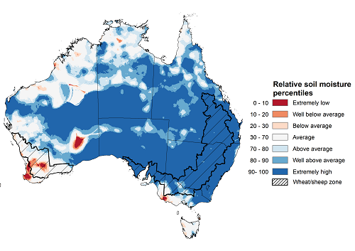
Source: Bureau of Meteorology (Australian Water Resources Assessment Landscape model)
Lower layer soil moisture for November 2021 was well above average to extremely high for this time of year across much of Australia. Lower layer soil moisture was below average to well below average across scattered areas of western and northern Australia.
In cropping regions, lower layer soil moisture was well above average to extremely for much of New South Wales, Queensland, South Australia and northern Western Australia. Lower layer soil moisture was generally average for remaining cropping regions in Victoria and southern Western Australia. Lower layer soil moisture will be important in determining the yield prospects of summer crops.
Modelled lower layer soil moisture for November 2021
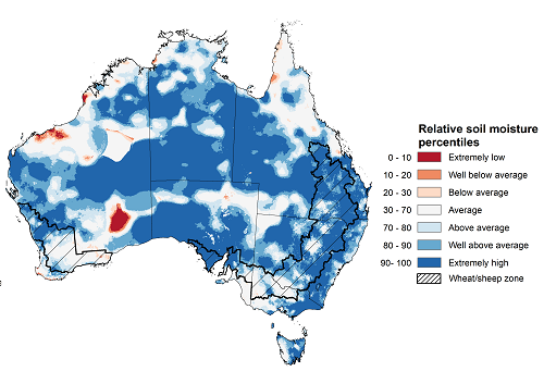
Source: Bureau of Meteorology (Australian Water Resources Assessment Landscape model)
November 2021 has been the wettest November on record for the New South Wales and Queensland wheat sheep zone, with many locations recorded rainfall totals 3 times higher than average for November. This has caused flooding in northern and central western regions of New South Wales and across south-east Queensland, resulting in grain production losses for producers in the worst affected areas.
These historically high rainfall totals and already saturated soils have resulted in extensive waterlogging of low-lying crops and pastures and led to localised and riverine flooding cutting road and rail networks across New South Wales and Queensland.
Flooding, as considered here, is generally a localised event and tends to follow river valleys, spreading across the flood plain and lower lying areas to varying extents. As a proportion of total land, the actual area of land affected is usually relatively small. Flood impacts can be caused by flash flooding or when floodwaters inundate an area for a long period of time. The recent flooding in eastern Australia has ranged from localised flash flooding to widespread flooding with extended periods of inundation.
Flood watch and warning areas as at 2 December 2021
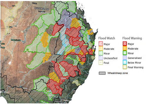
Key areas of focus are on major flooding across parts of the Western and Northern zones of New South Wales, including the upper-Hunter catchment, and catchments across South-East Queensland.
| Jurisdiction | River | Severity |
|---|---|---|
| New South Wales | Flood warning for mid-December -Barwon River at Mungindi Lachlan River at Jemalong Macquarie River at Warren Namoi River at Wee Waa | MAJOR |
| Queensland | Bremer River and Warril Creek Catchments Condamine River at Tummaville and downstream of Warwick to Loudoun Dawson River at Taroom Condamine River at Ranges Bridge, Macintyre Brook at Boggabilla Logan River at Beaudesert Macintyre River at Goondawindi Dumaresq River at Texas Warrill Creek at Harrisville Warrego River at Charleville | MAJOR |
| New South Wales | Bogan River at Dandaloo Severn River at Ashford Warrego River at Fords Bridge | MODERATE |
| Queensland | Cherwell River at Pacific Haven Bremer River to Walloon Balonne River at Surat Burnett River downstream of Paradise Dam Dogwood Creek at Gilweir Condamine River to Warwick Dawson River downstream of Theodore Lockyer and Laidley Creeks Logan River downstream of Yarrahappinni Paroo River to Eulo Weir River at Talwood | MODERATE |
It is too early to say what the full impact of flooding in parts of New South Wales and Queensland will be on agricultural producers and communities. Many farmers are still surveying the damage, with limited ability to undertake detailed assessments at this stage.
The more widespread effects of the heavy rainfall will be quality downgrades to unharvested crops, increased risks of flystrike and wool rot in sheep, and fungal damage to a range of crops. Grain, hay and cane harvests have all been disrupted. There are also reports that this year’s cane crushing has been put on hold.
Flooding and high rainfall is also likely to have damaged some early sown summer crops and could limit the ability to complete planting of summer crops if it remains too wet to get into paddocks.
Cereal crops have reportedly been worst affected as they are typically harvested later than canola. Cherry growers around Young are also reporting issues with splitting and mould, with Cherry Growers Australia estimating that more than 50 per cent of this year’s cherry crop has been lost.
Road and rail networks have also seen temporary cuts in some instances, and we expect there will be damage to farm fencing and roads. While ABARES does not expect this will reduce national crop tonnage, but likely to result significantly production losses for some producers.
Flooding is forecast to continue across many inland catchments over New South Wales this week. Further rain and storms are forecast, with a focus for increased thunderstorm activity near the Queensland border. This will cause renewed river rises in the North-West Slopes and Plains with the potential for additional flooding through the Northern Rivers.
There is a risk that this further high rainfall in December will cause further flood damage and harvest delays, creating more cases of crop losses and downgrades.
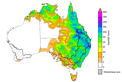
Over the 8-days to 9 December 2021 high pressure systems over the Great Australian Bight will bring clear, dry conditions to much of western and southern Australia. Meanwhile, a trough of low-pressure systems is expected to dominate eastern and northern Australia, drawing down moist, tropical air and resulting in storms and substantial rainfall over the next 8-days.
Rainfall totals of between 10 and 50 millimetres are forecast for eastern New South Wales and Victoria, much of Queensland, eastern Victoria, the Northern Territory and Tasmania, as well as isolated parts of South Australia and the north of Western Australia. Rainfall in excess of 50 millimetres is expected in parts of eastern New South Wales and the far north of the Northern Territory.
In Australian cropping regions, rainfall totals of between 10 and 50 millimetres are expected across much of central and northern New South Wales, Queensland and eastern Victoria. Little to no rainfall is forecast for cropping regions in western Victoria, South Australia and Western Australia during the next 8-days.
The rainfall expected across New South Wales and Queensland follows extremely high rainfalls in November and already saturated soil profiles. Continued flooding across multiple catchments is expected, and the wet conditions have the potential to adversely affect mature winter crops due to lodging, grain sprouting and fungal staining issues. Harvesting of winter crops and planting of summer crops are likely to be further delayed. In contrast, the dry conditions in western Victoria and South Australia will supported the maturing and harvesting of winter crops. Continued dry weather across Western Australia is expected to see the harvest of a forecast record winter crop to continue largely uninterrupted and maintain good grain quality.
For summer crops, the wet conditions could negatively affect their germination and establishment, as well as impeding nutrient availability. Given that soil profiles are already largely saturated, the expected rainfall is unlikely to provide additional soil moisture for later in the season.
Total forecast rainfall (mm) for the period 2 December to 9 December 2021
Note: This rainfall forecast is produced from computer models. As the model outputs are not altered by weather forecasters, it is important to check local forecasts and warnings issued by the Bureau of Meteorology.
Water
Water storages, water markets and water allocations - current week
The Tableau dashboard may not meet accessibility requirements. For information about the contents of these dashboards contact ABARES.

Commodities
Information on weekly price changes in agricultural commodities is now available at the Weekly commodity price update.