
Key issues
- For the week ending 2 March 2022, low-pressure troughs have continued to bring heavy rainfall to eastern parts of the country. The rainfall has resulted in significant flooding to parts of northern New South Wales and south-east Queensland. Meanwhile, Tropical Cyclone Anika brought strong winds and substantial rainfall to north-western parts of the country.
- In northern New South Wales and southern Queensland cropping regions, harvesting activity of early sown summer crops was well underway, with a small proportion of the crop likely impacted by the recent rainfall and flooding. For summer crops with longer growing periods, the recent rainfall may have caused some damage, but likely benefited many crops through increased plant water availability. Recent rainfall in parts of Central Queensland will likewise have benefited the germination and establishment of late sown summer crops.
- Rainfall during February 2022 was 14% below average for Australia as a whole. Below average rainfall was recorded across most of Tasmania, the southern coast of Western Australia, the northern tropics and Tasmania. However, February rainfall was above average for parts of eastern New South Wales, south-east Queensland, including the Darling Downs, and the Wide Bay and Burnett regions, central Australia, the Eyre Peninsula in South Australia and western parts of Western Australia.
- Summer 2021–22 rainfall was close to average for Australia as a whole, but significant differences were observed between regions and months. A La Niña event throughout the summer contributed to above average rainfall for parts of eastern Australia, with some regions recording their highest total summer rainfall on record. However, high pressure systems and weaker than average westerly winds to the south led to below average rainfall to many coastal regions in southern Australia.
- Intense rainfall during late February 2022 has led to flash flooding and riverine flooding across large areas of south-east Queensland and the Sunshine Coast, as well as parts of New South Wales, as high daily totals fell on already saturated catchments. This has likely resulted in summer grain and horticultural production losses for producers in the worst affected areas.
- Over the 8-days to 10 March 2022, a series of low-pressure systems and troughs in eastern Australia are expected to draw in moisture-laden air resulting in heavy rainfall and continued localised flooding for parts of New South Wales and Queensland.
- Water storage in the Murray–Darling Basin (MDB) decreased by 35 gigalitres (GL) between 23 February 2022 and 2 March 2022. The current volume of water held in storage is 22,224 GL, which represents 88 of total capacity. This is 65% or 8,770 GL more than at the same time last year.
- Allocation prices in the Victorian Murray below the Barmah Choke increased from $66 per ML on 19 February 2022 to $70 per ML on 25 February 2022. Prices are lower in the Murrumbidgee and regions above the Barmah choke due to the binding of the Murrumbidgee export limit and Barmah choke trade constraint.
Climate
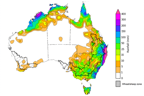
For the week ending 2 March 2022, low-pressure troughs have continued to bring heavy rainfall to eastern parts of the country. The rainfall has resulted in significant flooding to parts of northern New South Wales and south-east Queensland. Meanwhile, Tropical Cyclone Anika brought strong winds and substantial rainfall to north-western parts of the country. In the south, high-pressure systems resulted in clear, dry conditions for large areas of central, western and southern Australia.
Rainfall totals of between 10 and 100 millimetres were recorded across eastern and southern New South Wales, eastern and northern Queensland, much of Victoria, northern parts of Western Australia and the Northern Territory, as well as Tasmania. Rainfall totals in excess of 100 millimetres were recorded in parts of eastern New South Wales, south-eastern and northern Queensland and northern parts of Western Australia and the Northern Territory. Remaining parts of Australia received little to no rainfall.
In cropping regions, rainfall totals of between 10 and 100 millimetres were recorded across large parts of New South Wales, southern Queensland and Victoria. Rainfall in excess of 100 millimetres was recorded in some cropping regions of southern Queensland. Little to no rainfall was recorded across cropping regions in South Australia and Western Australia.
Flooding has been observed in some cropping regions of southern Queensland. In these regions, harvesting activity of early sown summer crops was well underway, with a small proportion of the crop likely impacted by the recent rainfall and flooding. For summer crops with longer growing periods, the recent rainfall may have caused some damage, but likely benefited many crops through increased plant water availability. Recent rainfall in parts of Central Queensland will likewise have benefited the germination and establishment of late sown summer crops.
Rainfall for the week ending 2 March 2022
Note: The rainfall analyses and associated maps utilise data contained in the Bureau of Meteorology climate database, the Australian Data Archive for Meteorology (ADAM). The analyses are initially produced automatically from real-time data with limited quality control. They are intended to provide a general overview of rainfall across Australia as quickly as possible after the observations are received. For further information go to http://www.bom.gov.au/climate/rainfall/
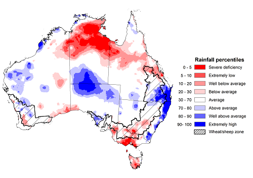
Rainfall during February 2022 was 14% below average for Australia as a whole. Below average rainfall was recorded across most of Tasmania, the southern coast of Western Australia, the northern tropics and Tasmania. However, February rainfall was above average for parts of eastern New South Wales, south-east Queensland, including the Darling Downs, and the Wide Bay and Burnett regions, central Australia, the Eyre Peninsula in South Australia and western parts of Western Australia. The Sunshine Coast and coastal parts of south-east Queensland received the highest rainfall on record for February, contributing to significant flooding towards the end of the month.
An active La Niña event in the Pacific and a positive Southern Annular Mode were the main climate influences during the month. Coastal troughs over southern Queensland and northern New South Wales, combined with humid onshore airflow, resulted in the extremely high rainfall totals. Blocking high pressure systems to the south of Australia contributed to the persistence of the coastal troughs in the region.
February rainfall was average to above average across cropping regions of northern New South Wales and southern Queensland, the Eyre Peninsula in South Australia and northern cropping regions of Western Australia. Average to below average falls dominated cropping regions in southern New South Wales, northern Queensland, Victoria and southern parts Western Australia.
Much of the rainfall received in northern New South Wales and southern Queensland was received towards the end of February, with relatively dry conditions throughout the month allowing harvesting of early sown summer crops to continue unimpeded.
Rainfall percentiles for February 2022
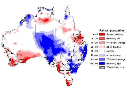
Summer 2021–22 rainfall was close to average for Australia as a whole, but significant differences were observed between regions and months. A La Niña event throughout the summer contributed to above average rainfall for parts of eastern Australia, with some regions recording their highest total summer rainfall on record. However, high pressure systems and weaker than average westerly winds to the south led to below average rainfall to many coastal regions in southern Australia. Rainfall was above average to extremely high along the east coast of Australia, southern New South Wales, central and southern parts of South Australia, the southern half of the Northern Territory and isolated parts of northern Australia.
The season began with the fourth wettest December on record, although much of the rainfall occurred across northern and western parts of Australia. The above average rainfall at the start of summer followed the wettest November on record, boosting soil moisture levels across summer cropping regions. Continued rainfall into early January will have supported yield potentials through critical periods of flowering and grain filling for early sown crops, while dry conditions in late January and much of February allowed field access for harvesting activities.
Owing to the favourable conditions, early sown summer crops across northern New South Wales and southern Queensland have resulted in well above average yields and grain quality. Late sown summer crops in Central Queensland will also benefit from increased rainfall given the dry conditions thus far.
Rainfall percentiles for summer 2022 (1 December 2021 to 28 February 2022)
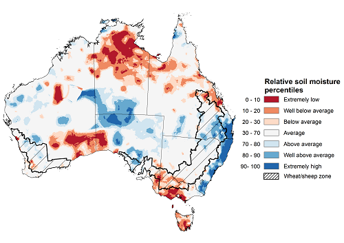
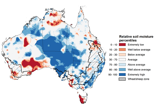
Upper layer soil moisture in February 2022 was average for this time of year across much of New South Wales, Queensland and South Australia, eastern Victoria, large parts of Western Australia and the south of the Northern Territory. Modelled upper layer soil moisture was extremely low for parts of northern Queensland, western and central Victoria, the south-east of Western Australia, northern parts of the Northern Territory and much of Tasmania due to below average rainfall in these areas during February. Extremely high soil moisture was evident across eastern areas of New South Wales, south-east Queensland, central and northern parts of South Australia, eastern parts of Western Australia, as well as southern parts of the Northern Territory, reflecting the heavy rainfall in the latter parts of February.
At this time of year, upper layer soil moisture is important for late planted summer crops in the Central Queensland growing region since plant germination and establishment utilise this moisture. It is also important indicator of the ability to access paddocks to undertake harvest and planting activities.
Upper layer soil moisture was average to above average for this time of year across cropping regions in northern New South Wales, southern Queensland, the west of South Australia and northern parts of Western Australia. Upper layer soil moisture was extremely low to average for parts of the Central Queensland growing region, as well as Victoria and eastern parts of South Australia. Extremely high to above average upper layer soil moisture was evident in south-east Queensland cropping regions. Average levels of upper layer soil moisture would have supported the germination and establishment of late sown summer crops in Central Queensland. The harvesting of early sown summer crops in northern New South Wales and southern Queensland was well-advanced prior to the heavy rainfalls in late February. For unharvested crops, the above average upper-layer soil moisture will likely prevent paddock access in the short-term.
Modelled upper layer soil moisture for February 2022
Lower layer soil moisture for February 2022 was well above average to extremely high for this time of year across parts of north-western, south-eastern, south-central and central Australia. Lower layer soil moisture was well below average to below average across parts of central Queensland, western Victoria, the south of Western Australia, northern parts of the Northern Territory and western Tasmania, as well as along the southern border between South Australia and Victoria.
In cropping regions, lower layer soil moisture was well above average to extremely high for parts of southern and central New South Wales, southern Queensland, as well as central and western parts of South Australia. High levels of lower layer soil moisture will continue to support above average yield prospects for summer crops and above average pasture growth rates for this time of year across New South Wales and southern Queensland.
Modelled lower layer soil moisture for February 2022
Source: Bureau of Meteorology (Australian Water Resources Assessment Landscape model)
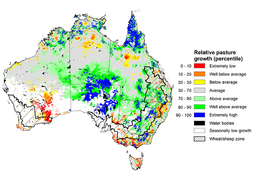
December to February is the peak pasture growth period which typically provides the bulk of feed to maintain production through the low pasture growth months of the northern dry season. Across southern Australia, December to February pasture growth is typically low reflecting lower rainfall totals, high temperatures and high evapotranspiration rates at this time of year. Pasture availability during this period influences the growth and branding and marking rates of lambs and calves, livestock turnoff and the production of meat, milk, and wool.
For the 3 months to February 2022, above average rainfall totals and mild summer temperatures resulted in average to well above average pasture production for this time of year across most grazing regions in New South Wales, Queensland, north-eastern Victoria, northern South Australia, northern Western Australia and the Northern Territory. Extremely low to below average pasture growth rates were recorded across southern Western Australia and southern Victoria, consistent with above average temperatures and/or below average rainfall. In contrast, below average pasture growth rates across parts of eastern New South Wales are likely the result of below average temperatures and waterlogged soils.
Average to extremely high pasture production across much of New South Wales, Queensland, South Australia, northern Western Australia and the Northern Territory will likely enable farmers to continue to rebuild stock numbers and provide opportunities to build standing dry matter availability. Below average rainfall in southern Victoria may have restricted summer pasture growth, however, it comes after extremely high pasture growth during winter and spring that supplied average to above average pasture availability and ample opportunities to conserve excess fodder.
Relative pasture growth for 3-months ending February 2022 (1 December to 28 February 2022)
Source: Queensland Department of Science, Information Technology and Innovation
Intense rainfall during late February 2022 has led to flash flooding and riverine flooding across large areas of south-east Queensland and the Sunshine Coast, as well as parts of New South Wales, as high daily totals fell on already saturated catchments. This has likely resulted in summer grain and horticultural production losses for producers in the worst affected areas.
Multi-day rainfall totals for the 6-days ending 9 am on 28 February were at least 2.5 times the February average rainfall across parts of south-east Queensland and north-east New South Wales, with some parts of Queensland having received in excess of 5 times their monthly average rainfall for February. Totals for the 6-days were above 200 mm over a large area from the New South Wales Mid North Coast to the Wide Bay and Burnett District in Queensland. More than 30 sites have reported 6-day totals in excess of 1,000 mm (1 metre of rain), with the highest totals mostly between the Gympie region and Numinbah.
These historically high rainfall totals and already saturated soils have resulted in extensive waterlogging of low-lying crops and pastures and led to localised and riverine flooding cutting road and rail networks across northern New South Wales and south-east Queensland.
Flooding, as considered here, is generally a localised event and tends to follow river valleys, spreading across the flood plain and lower lying areas to varying extents. As a proportion of total land, the actual area of land affected is usually relatively small. Flood impacts can be caused by flash flooding or when floodwaters inundate an area for a long period of time. The recent flooding in eastern Australia has ranged from localised flash flooding to widespread flooding with extended periods of inundation.
Flood watch and warning areas as at 2 March 2022
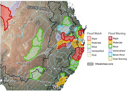
Key areas of focus are on major flooding across parts of the Eastern and Northern zones of New South Wales, including the Northern Rivers, Hunter / Central Rivers, Hawkesbury / Nepean and Sydney Metro catchments, and catchments across South-East Queensland. Hawkesbury / Nepean is of significant concern with major flooding with similar impact expected to the devastating 2021 event.
| Jurisdiction | River | Severity |
|---|---|---|
| New South Wales | Clarence River at Grafton, Ulmarra and Maclean George’s River at Liverpool Bridge Hawkesbury at North Richmond, Windsor and Lower Portland Nepean River at Menangle Bridge, Wallacia Weir and Penrith Richmond River at Kyogle, Coraki, Bungawalbyn and Woodburn Tuggerah Lake at Long Jetty | MAJOR |
| Queensland | Balonne River at Warkon Condamine River at Ranges Bridge and Chinchilla Weir Eyre Creek at Glengyle Logan River at Maclean Bridge, Waterford and Parklands Mary River at Tiaro Moonie River at Nindigully Weir River at Giddi Giddi South and Talwood | MAJOR |
| New South Wales | Colo River at Putty Road Deua River at Wamban Hawkesbury River at Wisemans Ferry Nepean River at Camden Weir Orara River at Coutts Crossing Shoalhaven River at Nowra and Terara Tweed River at Tumbulgum and Chinderah Wilsons River at Lismore | MODERATE |
| Queensland | Balonne River at Surat Brisbane River at Brisbane City and Mt Crosby Condamine River at Cecil Plains and Condamine Eyre Creek at Bedourie Georgina River at Cluny Mary River at Miva | MODERATE |
It is too early to say what the full impact of flooding in parts of New South Wales and Queensland will be on agricultural producers and communities. Many farmers are still surveying the damage, with limited ability to undertake detailed assessments at this stage.
The more widespread effects of the heavy rainfall will be quality downgrades to ready-to-harvest summer crops and fungal damage to a range of crops. The summer grain harvest and sugarcane planting have also been disrupted.
Flooding and high rainfall is also likely to have damaged some early sown summer crops and could limit the ability to complete planting of summer crops if it remains too wet to get into paddocks.
Road and rail networks have also seen temporary cuts in some instances, and we expect there will be damage to farm fencing and roads. While ABARES does not expect this will reduce national crop tonnage for summer crops, it is likely to result significantly production losses for some producers.
Flooding is forecast to continue across many coastal catchments over New South Wales this week. Further rain and storms are forecast, with a focus for increased thunderstorm activity in eastern New South Wales. This will cause renewed river rises in the Northern Rivers, with the potential for additional flooding through the Hunter / Central Rivers, Hawkesbury / Nepean, Southern Rivers and Sydney Metro.
There is a risk that this further high rainfall in March will cause further flood damage and harvest delays, creating more cases of crop losses and downgrades.
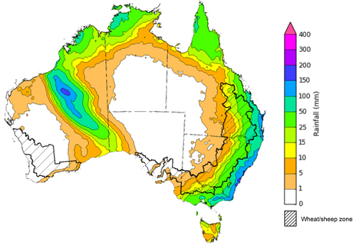
Over the 8-days to 10 March 2022, a series of low-pressure systems and troughs in eastern Australia are expected to draw in moisture-laden air resulting in heavy rainfall and continued localised flooding for parts of New South Wales and Queensland. Likewise, Ex-Tropical Cyclone Anika is expected to generate intense wind, rain and storms across northern and central areas of Western Australia. Meanwhile, high pressure systems are expected to bring mostly dry conditions to the remainder of western, central and southern Australia.
Rainfall totals of between 10 and 100 millimetres are forecast for eastern New South Wales, much of Victoria, eastern and northern parts of Queensland, as well as northern and central parts of Western Australia, the far north of the Northern Territory and parts of Tasmania. Rainfall in excess of 100 millimetres is expected in coastal areas of eastern New South Wales, eastern Victoria and Queensland, as well as northern parts of Queensland and the Northern Territory, and central and northern Western Australia
In Australian cropping regions, rainfall totals of between 10 and 100 millimetres are expected across much of New South Wales and Queensland, and eastern Victoria. Little to no rainfall is forecast for all remaining cropping regions during the next 8-days.
The forecast rainfall across summer cropping regions will further add to the rainfall received over the past two weeks, increasing soil moisture levels. As a consequence, the tail end of harvesting of early sown summer crops is likely to be delayed and downgrades in grain quality due to sprouting can now be expected in northern New South Wales and southern Queensland. For later sown summer crops, the expected rainfall will continue to improve plant available moisture and assist with crop establishment. For early sown summer crops with longer growth periods, such as cotton, the expected rainfall will help support them through critical stages of flowering and boll filling.
Total forecast rainfall (mm) for the period 3 March to 10 March 2022
Note: This rainfall forecast is produced from computer models. As the model outputs are not altered by weather forecasters, it is important to check local forecasts and warnings issued by the Bureau of Meteorology.
Water
Water storages, water markets and water allocations - current week
The Tableau dashboard may not meet accessibility requirements. For information about the contents of these dashboards contact ABARES.

Commodities
Information on weekly price changes in agricultural commodities is now available at the Weekly commodity price update.