Key issues
- For the week ending 6 July 2022, a cloud band across northern Australia brought rainfall to the northern tropics, while an East Coast Low resulted in significant rainfall and flooding to parts of eastern New South Wales. Meanwhile, high-pressure systems dominated southern and western parts of the country bringing clear, dry conditions.
- The return of heavy rainfall across parts of New South Wales and Queensland has likely interrupted the harvest of remaining summer crops and planting of winter crops. Dry conditions in recent weeks had allowed significant harvesting progress, but it is understood that summer crops are yet to be harvested in parts of New South Wales. The substantial rainfalls have led to localised flooding, which may lead to yield reductions for winter crops if fields remain inundated.
- Intense rainfall in early July 2022 has led to flash flooding and riverine flooding across large areas of the New South Wales eastern seaboard. This has likely resulted in horticultural and dairy production losses for producers in the worst affected areas. The recent heavy rainfall may also lead to yield loses in some recently sown crops due to lengthy inundation and could limit the ability to complete planting of winter crops if it remains too wet to get into paddocks.
- Rainfall during June 2022 was 22% below average for Australia as a whole. Rainfall was above average to extremely high for parts of southern Victoria, the northern tropics and the south-west of Tasmania. However, rainfall was extremely low to below average for most of New South Wales, parts of eastern and central Queensland, the east of South Australia and the south-west of Western Australia.
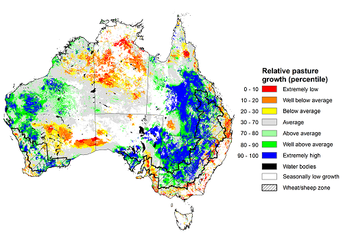
- For the 3 months to June 2022, well above average rainfall totals and mild temperatures resulted in well above average to extremely high pasture production for this time of year across most grazing regions in central and western New South Wales, southern and central Queensland, western and northern Victoria, north-eastern and south-central South Australia, as well as western and central parts of Western Australia.
- Over the 8-days to 14 July 2022, a cold front across southern Australia is expected to bring light to moderate rainfall. For much of the country, a high-pressure-system will dominate, resulting in clear, dry conditions. The forecast dry conditions across cropping regions in New South Wales and Queensland will allow growers not impacted by recent heavy rainfall to finalise the harvest of summer crops and sowing of winter cereals.
- Water storage in the Murray–Darling Basin (MDB) increased by 114 gigalitres (GL) between 29 June 2022 and 6 July 2022. The current volume of water held in storage is 22,273 GL, which represents 88 of total capacity. This is 33% or 5,488 GL more than at the same time last year.
- Allocation prices in the Victorian Murray below the Barmah Choke increased from $11 per ML on 24 June 2022 to $80 per ML on 7 July 2022. Export limits are binding for the NSW Murrumbidgee and the Victorian Goulburn. Trade from above the Barmah choke to below is closed. The large increase in prices in all regions is due to the start of the new water year.
Climate
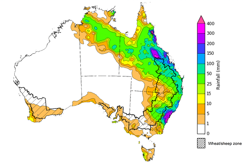
For the week ending 6 July 2022, a cloud band across northern Australia brought rainfall to the northern tropics, while an East Coast Low resulted in significant rainfall and flooding to parts of eastern New South Wales. Meanwhile, high-pressure systems dominated southern and western parts of the country bringing clear, dry conditions.
Rainfall totals of between 10 and 50 millimetres were recorded in eastern and central New South Wales, much of Queensland, northern parts of the Northern Territory, as well as isolated parts of Victoria, South Australia, Western Australia and western Tasmania. Rainfall totals in excess of 50 millimetres were recorded across eastern New South Wales, and eastern and western Queensland. Remaining parts of Australia received little to no rainfall.
In Australian cropping regions, rainfall totals of between 10 and 50 millimetres were recorded in central and north-eastern New South Wales, as well as south-eastern, central and northern Queensland and isolated parts of Victoria. Rainfall totals in excess of 50 millimetres were recorded in east-central parts of New South Wales and central and northern Queensland. Little to no rainfall was recorded across remaining cropping regions for the week ending 6 July 2022.
The return of heavy rainfall across parts of New South Wales and Queensland has likely interrupted the harvest of remaining summer crops and planting of winter crops. Dry conditions in recent weeks had allowed significant harvesting progress, but it is understood that summer crops are yet to be harvested in parts of New South Wales. The substantial rainfalls have led to localised flooding, which may lead to yield reductions for winter crops if fields remain inundated. The wet conditions are likely to bring winter planting to an end for affected regions too. For growing regions across Victoria, South Australia and Western Australia, winter growing conditions have been favourable thus far, but dry conditions have persisted over the past week. Consequently, soil moisture levels have continued to decline, reaching below average to average levels in most regions.
Rainfall for the week ending 6 July 2022
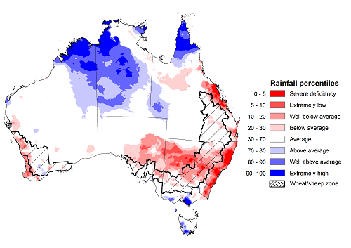
Rainfall during June 2022 was 22% below average for Australia as a whole. The main climate influences for June were a dissipating La Niña event in the Pacific and the likely development of a negative Indian Ocean Dipole (IOD). Both a La Niña and a negative IOD are associated with above average rainfall for eastern Australia. However, high-pressure systems dominated much of southern Australia throughout June, resulting in below average to average rainfall.
Rainfall was above average to extremely high for parts of southern Victoria, the northern tropics and the south-west of Tasmania. However, rainfall was extremely low to below average for most of New South Wales, parts of eastern and central Queensland, the east of South Australia and the south-west of Western Australia.
June rainfall was average to above average across cropping regions in isolated parts of Western Australia. Below average falls recorded in cropping regions of New South Wales, isolated parts of Queensland, northern Victoria, much of South Australia, as well as western and southern parts of Western Australia.
The below average rainfall across New South Wales followed above average rainfalls in March and April, which allowed soil profiles to drain. Therefore, significant progress was made in the delayed harvest of summer crops and the planting of winter crops. Previous heavy opening rainfalls across southern cropping regions have provided a positive start to the winter cropping season, with the below average to average rainfall across southern cropping regions having a negligible impact on crop development.
Rainfall percentiles for June 2022
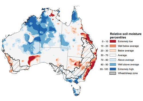
Upper layer soil moisture in June 2022 was extremely low for this time of year across eastern and central New South Wales, parts of eastern Queensland, the south-east of Western Australia and isolated parts in the north of the Northern Territory. Extremely high upper layer soil moisture was evident in far northern and western Queensland, alpine areas, southern Victoria, northern and eastern parts of Western Australia, western and central parts of the Northern Territory, as well as southern and western Tasmania reflecting heavy rainfall events in these areas. Modelled upper layer soil moisture was generally average across the remainder of the country.
At this time of year, upper layer soil moisture is important for the establishment and early development of winter crops across Australian cropping regions. It is also important indicator of the ability to access paddocks to undertake harvesting of summer crops in New South Wales and Queensland, as well as planting activities for winter crops.
Upper layer soil moisture was average to above average for this time of year across cropping regions in isolated parts of southern New South Wales, eastern Victoria and central parts of South Australia. Upper layer soil moisture was below average for much of central and northern New South Wales, isolated parts of Queensland and the west of Western Australian growing regions. Following extremely high upper layer soil moisture in previous months, the below average to average upper layer soil moisture conditions in June across New South Wales and Queensland have allowed field access.
Modelled upper layer soil moisture for June 2022
Source: Bureau of Meteorology (Australian Water Resources Assessment Landscape model)
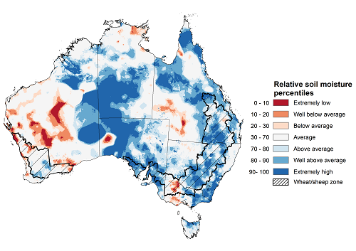
Lower layer soil moisture for June 2022 was well above average to extremely high for this time of year across eastern and central New South Wales, parts of south-eastern, central and northern Queensland, eastern Victoria, as well as much of South Australia, the east and south-west of Western Australia, large areas in the south and centre of the Northern Territory and northern Tasmania. Lower layer soil moisture was well below average to below average in south-western Queensland, western Victoria, isolated parts of western South Australia, the centre and west of Western Australia and the far north of the Northern Territory.
In cropping regions, lower layer soil moisture was well above average to extremely high across much of New South Wales, Queensland and South Australia, as well as eastern parts of Victoria and central areas of Western Australia. Lower layer soil moisture was extremely low to below average for parts of western Victoria and isolated parts of the east and west of Western Australian cropping regions. The above average lower layer soil moisture will support yield potentials across New South Wales, Queensland and South Australia as winter crops continue to develop and their root systems extend into lower soil layers. Conversely, below average lower layer soil moisture in western Victoria and parts of Western Australia may reduce yield potentials without further rainfall in the coming months.
Modelled lower layer soil moisture for June 2022
Source: Bureau of Meteorology (Australian Water Resources Assessment Landscape model)
As northern Australia enters the dry season, pasture growth declines significantly due to the reduction in water availability, with livestock relying on pasture grown throughout the previous wet season. As south-eastern Australia enters winter, pasture growth typically increases, reflecting higher rainfall totals, and reduced temperatures and evapotranspiration rates at this time of year. Pasture availability during this period influences the growth and branding and marking rates of lambs and calves, livestock turnoff and the production of meat, milk, and wool.
For the 3 months to June 2022, well above average rainfall totals and mild temperatures resulted in well above average to extremely high pasture production for this time of year across most grazing regions in central and western New South Wales, southern and central Queensland, western and northern Victoria, north-eastern and south-central South Australia, as well as western and central parts of Western Australia. Extremely low to below average pasture growth rates were recorded across parts of eastern New South Wales and Victoria, south-eastern and northern Queensland, the south-east and far west of South Australia, the south-east, south-central and far north of Western Australia and much of the Northern Territory. The below average growth in western and northern Australia reflects low rainfall conditions. In contrast, below average pasture growth rates across parts of eastern New South Wales and south-eastern Queensland are likely the result of waterlogged soils.
Average to extremely high pasture production across much of New South Wales, Victoria, Queensland, South Australia, and the west of Western Australia will likely enable farmers to continue to rebuild stock numbers and provide opportunities to build standing dry matter availability. Below average temperatures and waterlogged soils across eastern New South Wales and south-eastern Queensland contributed to restricted summer pasture growth. However, it comes after extremely high pasture growth during winter and spring 2021that supplied average to above average pasture availability and ample opportunities to conserve excess fodder.
Relative pasture growth for 3-months ending June 2022 (1 April to 30 June 2022)
Source: Queensland Department of Science, Information Technology and Innovation
Intense rainfall in early July 2022 has led to flash flooding and riverine flooding across large areas of the New South Wales eastern seaboard. This has likely resulted in horticultural and dairy production losses for producers in the worst affected areas.
An East Coast Low brought significant rainfall to large areas of New South Wales since Sunday, with some areas receiving four times the July month average in three days. Flood levels across multiple catchments exceeded levels recorded in March 2022. The highest daily rainfall total was recorded at Darkes Forest (298 millimetres) in the 24 hours to 9am on 3 July, with multiple other sites recording daily totals in excess of 150 millimetres. The highest weekly rainfall total was recorded at Beaumont (582.6 millimetres), with pockets of rainfall reaching 200-400 millimetres in the Sydney and Illawarra regions.
The heavy rainfalls recorded across New South Wales in early July follows below average rainfall throughout June 2022. Despite above average rainfall throughout summer and flooding across eastern New South Wales in March, the dry conditions in June had allowed upper layer soil moisture levels to subside.
Flooding, as considered here, is generally a localised event and tends to follow river valleys, spreading across the flood plain and lower lying areas to varying extents. As a proportion of total land, the actual area of land affected is usually relatively small. Flood impacts can be caused by flash flooding or when floodwaters inundate an area for a long period of time. The recent flooding in eastern Australia has ranged from localised flash flooding to widespread flooding.
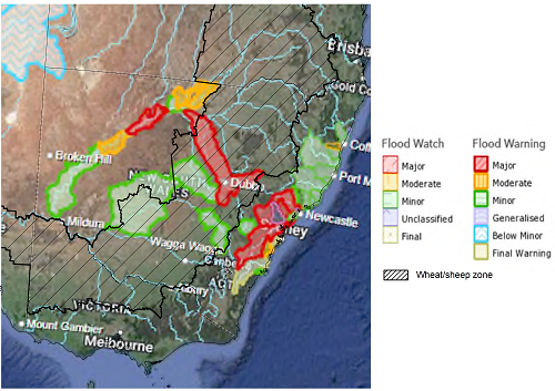
Flood watch and warning areas as at 6 July 2022
Flood warnings are currently in place for the Nepean, Hawkesbury and Colo Rivers, Lower Hunter River, Wollombi Brook, Paterson and Williams Rivers, Tuggerah Lake, Bellinger River, Nambucca River, Orara River, Lake Macquarie, Bogan River, Macquarie River, Lachlan River, Culgoa and Bokhara Rivers, Bogan River and Darling River.
| Jurisdiction | River | Severity |
|---|---|---|
| New South Wales | Darling River at Tilpa Hawkesbury River at North Richmond and Wisemans Ferry Lower Hunter River at Singleton Macquarie River at Warren Tuggerah Lake at Long Jetty Wollombi Brook at Bulga | MAJOR |
| New South Wales | Bogan River at Dandaloo Culgoa River at Kenebree Darling River at Louth and Wilcannia Hawkesbury River at Lower Portland, Windsor and Sackville Hunter River at Maitland Manning River at Wingham and Taree | MODERATE |
It is too early to say what the full impact of flooding in parts of New South Wales will be on agricultural producers and communities. As the event is still ongoing many farmers will still be surveying the damage, with limited ability to undertake detailed assessments at this stage.
The heavy rainfall has also extended inland to the central-west region with falls of between 25 and 100 millimetres being recorded across central grain growing regions. The recent heavy rainfall may lead to yield loses in some recently sown crops due to lengthy inundation and could limit the ability to complete planting of winter crops if it remains too wet to get into paddocks. For dairy, road closures in some regions are likely to prevent the collection of milk, and power failures will prevent milking activities and the ability to safely store milk awaiting collection. The floods could also increase the incidence of mastitis and loss of milk production due to stress. Infrastructure, crops and feed stores are also likely to have been damaged on some farms.
Road and rail networks are also likely to have seen temporary cuts in some instances, and we expect there will be extensive localised damage to farm buildings, fencing and roads. Supply chain impacts on processors and transport logistics will be important in what the overall impacts are on the sector. Flooding is forecast to continue across many coastal catchments over New South Wales this week as flood peaks move downstream. However, rainfall is expected to ease over the coming days.
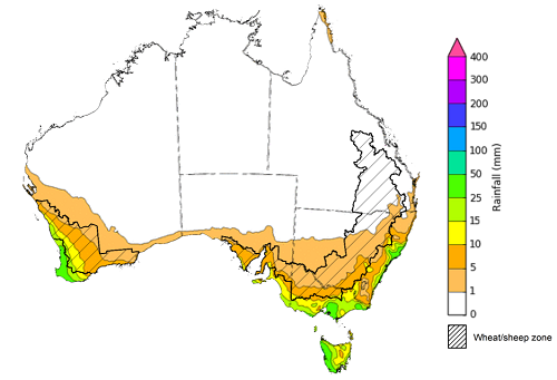
Over the 8-days to 14 July 2022, a cold front across southern Australia is expected to bring light to moderate rainfall. For much of the country, a high-pressure-system will dominate, resulting in clear, dry conditions.
Rainfall totals of between 10 and 50 millimetres are forecast for isolated parts of eastern New South Wales, alpine regions, southern Victoria, the south-east of South Australia, the south-west of Western Australia and most of Tasmania. Little to no rainfall is forecast across remaining parts of Australia over the next 8-days.
In Australian cropping regions, rainfall totals of between 10 and 50 millimetres are expected across western parts of Western Australia. Little to no rainfall is forecast for all remaining cropping regions during the next 8-days.
The forecast dry conditions across cropping regions in New South Wales and Queensland will allow growers not impacted by recent heavy rainfall to finalise the harvest of summer crops and sowing of winter cereals. The dry conditions will also allow soil profiles to drain in those areas impacted by the recent heavy rainfall. If dry conditions persist, growers will be able to access fields and undertake post-emergence spraying and replanting if necessary. Above average soil moisture levels across much of New South Wales and Queensland will support winter crops in establishment and early development. Meanwhile, dry conditions across Victoria, South Australia and Western Australia will see soil moisture levels continuing to decline, with Western Australian crops most at risk of yield penalties if further rainfall doesn’t eventuate over the coming weeks.
Total forecast rainfall (mm) for the period 7 July to 14 July 2022
Note: This rainfall forecast is produced from computer models. As the model outputs are not altered by weather forecasters, it is important to check local forecasts and warnings issued by the Bureau of Meteorology.
Water
Water storages, water markets and water allocations - current week
The Tableau dashboard may not meet accessibility requirements. For information about the contents of these dashboards contact ABARES.
Commodities
Information on weekly price changes in agricultural commodities is now available at the Weekly commodity price update.

