
Key issues
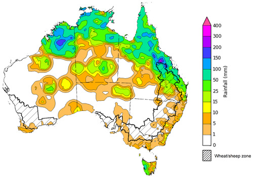
- For the week ending 30 November 2022, high-pressure systems brought dry conditions to much of the southern Australia. Weekly rainfall totals exceeding 50 millimetres were observed across north-eastern Queensland, northern and central Western Australia and the Northern Territory, as well as isolated parts of northern South Australia and western Tasmania.
- A week of little to no rainfall across cropping regions in New South Wales, southern Queensland, Victoria, South Australia and Western Australia has benefitted winter crop harvesting. Across northern New South Wales and southern Queensland little rainfall is also likely to have allowed improved field access for the sowing of summer crops. The wet conditions across northern and central Queensland are likely to have stalled winter crop harvest and summer crop planting activities, and negatively grain quality in unharvested winter crops.
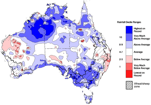
- November 2022 rainfall was very much above average across cropping regions of southern New South Wales, western and eastern Victoria, South Australia and south-eastern parts of Western Australia. November rainfall was generally average for remaining cropping regions. The very much above average rainfall in November is likely to have delayed winter crop harvesting across parts of New South Wales, Victoria and South Australia. The heavy rainfall is also likely to have further delayed the planting of summer crops across southern New South Wales.
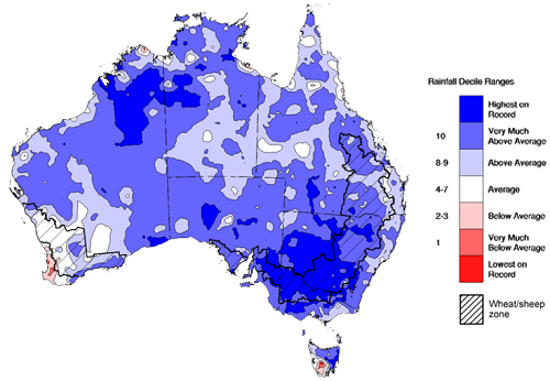
- Spring 2022 rainfall was the second highest spring rainfall on record for Australia as a whole, and the highest on record in New South Wales and Victoria. Highest on record spring rainfall across large areas of New South Wales following well above average August rainfall has led to saturated soils in most cropping regions. Significant winter crop losses are expected, caused by widespread river flooding and damage to yield prospects for inundated crops across much of the state. Summer crops are also likely to be negatively impacted in the short-term - due to delays resulting in less than optimum planting conditions or preventing the planting of some summer crops - but will benefit yield potential due to ample plant available moisture going forward.
- Over the 8-days to 8 December 2022, high-pressure systems are forecast to bring dry condition to much of Australia. Meanwhile, low-pressure systems and a broad trough is forecast to bring moderate to heavy rainfall to eastern Queensland. The easing of wet conditions across flood-affected cropping regions of eastern Australia will likely further allow floodwaters to recede and reduce the risk of waterlogging and reductions in yield potential. The forecast drier conditions are also expected to provide an opportunity for soils to drain and allow improved access to fields for harvest and planting activities.
- Water storage levels in the Murray-Darling Basin (MDB) decreased between 23 November 2022 and 30 November 2022 by 180 gigalitres (GL). Current volume of water held in storage is 23 767 GL which represents 94 per cent of total capacity. This is 4 percent or 817 GL more than at the same time last year.
- Allocation prices in the Victorian Murray below the Barmah Choke increased from $26 per ML on 21 November to $37 per ML on 1 December 2022. Prices are lower in the Goulburn-Broken, Murrumbidgee and regions above the Barmah choke due to the binding of the Murrumbidgee export limit, Goulburn intervalley trade limit and Barmah choke trade constraint.
Climate
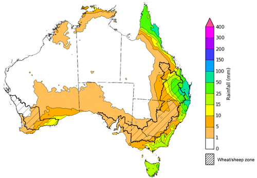
For the week ending 30 November 2022, high-pressure systems brought dry conditions to much of the southern two thirds Australia. Weekly rainfall totals exceeding 50 millimetres were observed across north-eastern Queensland, northern and central Western Australia and the Northern Territory, as well as isolated parts of northern South Australia and western Tasmania. Meanwhile, mostly dry conditions were observed across remaining parts of Australia.
In Australian cropping regions, rainfall totals of between 10 and 100 millimetres were recorded across areas of northern and central Queensland. Little to no rainfall was recorded in remaining cropping regions for the week ending 30 November 2022.
A week of little to no rainfall across cropping regions in New South Wales, southern Queensland, Victoria, South Australia and Western Australia has benefitted winter crop harvesting. Across northern New South Wales and southern Queensland little rainfall is also likely to have allowed improved field access for the sowing of summer crops. The wet conditions across northern and central Queensland are likely to have stalled winter crop harvest and summer crop planting activities, and negatively grain quality in unharvested winter crops.
Rainfall for the week ending 30 November 2022
Note: The rainfall analyses and associated maps utilise data contained in the Bureau of Meteorology climate database, the Australian Data Archive for Meteorology (ADAM). The analyses are initially produced automatically from real-time data with limited quality control. They are intended to provide a general overview of rainfall across Australia as quickly as possible after the observations are received. For further information go to http://www.bom.gov.au/climate/rainfall/
Rainfall during November 2022 was very much above average across southern New South Wales, and much of Victoria, southern South Australia, northern Western Australia, parts of northern Queensland and the north of the Northern Territory. In contrast, below average to average rainfall was recorded across scattered parts of south-east Queensland, north-east New South Wales, central South Australia, and north-west Western Australia.
The main climate influences for November were a negative Indian Ocean Dipole (IOD), a positive Southern Annular Mode (SAM) and the continued La Niña event in the Pacific Ocean. A negative IOD typically results in enhanced rainfall in a broad band extending from the north-west to the south-east of Australia. A positive SAM is associated with increased rainfall across parts of eastern Australia but less rainfall for parts of southern Australia. La Niña events tend to increase rainfall across eastern, central and north-west Australia.
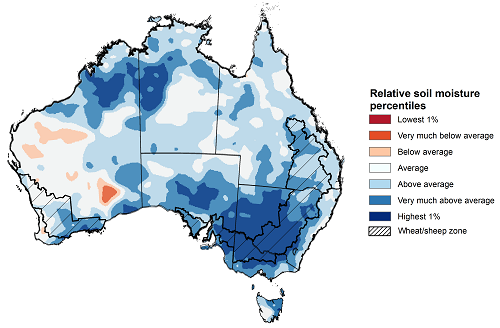
November 2022 rainfall was very much above average across cropping regions of southern New South Wales, western and eastern Victoria, South Australia and south-eastern parts of Western Australia. November rainfall was generally average for remaining cropping regions. The very much above average rainfall in November is likely to have delayed winter crop harvesting across parts of New South Wales, Victoria and South Australia. The heavy rainfall is also likely to have further delayed the planting of summer crops across southern New South Wales.
Rainfall percentiles for November 2022
Spring 2022 rainfall was the second highest spring rainfall on record for Australia as a whole, and the highest on record in New South Wales and Victoria. Rainfall during spring 2022 was above average to very much above the national long-term average for much of Australia, with the build-up of a La Niña event and a negative Indian Ocean Dipole (IOD) influencing Australia’s climate. In contrast, rainfall was below average for isolated parts of the far southwest of Western Australia, as well as parts of south-western Tasmania.
The season began with extremely high rainfall across most cropping regions in New South Wales, southern Queensland, Victoria and eastern South Australia during September. Meanwhile, cropping regions in western South Australia and Western Australia received generally average rainfall during September. The wet conditions across eastern states were reinforced in October with extremely high rainfall for most cropping regions while cropping regions in central and northern Western Australia saw generally average rainfall. Well above average rainfall has continued through November 2022 across southern New South Wales, Victoria and South Australia. Generally average to above average rainfall during November was recorded across remaining cropping regions.
The above average rainfall at the start of spring boosted soil moisture levels across eastern cropping regions, supporting yield potentials leading into the critical periods of flowering and grain filling. However, record rainfall totals during October and November have led to significant flooding events and widespread water logging occurred in large parts of eastern Australia, in some cases lasting for prolonged periods and recurring in multiple events. Highest on record spring rainfall across large areas of New South Wales following well above average August rainfall has led to saturated soils in most cropping regions. Significant winter crop losses are expected, caused by widespread river flooding and damage to yield prospects for inundated crops across much of the state.
Summer crops are also likely to be negatively impacted in the short-term - due to delays resulting in less than optimum planting conditions or preventing the planting of some summer crops - but will benefit yield potential due to ample plant available moisture going forward.
Rainfall percentiles for spring 2022 (1 September to 30 November 2022)
Upper layer soil moisture for November 2022 was extremely high for this time of year across much of New South Wales, Victoria, western Queensland and South Australia, as well as parts of southern and north-eastern Western Australia, north-eastern Tasmania and large areas of the Northern Territory, reflecting high monthly rainfall in these areas. Below average upper layer soil moisture was evident across isolated parts of south-eastern Queensland, north-eastern New South Wales and the northwest and central Western Australia. Modelled upper layer soil moisture was generally average to above average across the remainder of the country.
At this time of year, upper layer soil moisture is important at the beginning of the summer cropping season and for pasture growth across northern Australia since plant germination and establishment utilise this moisture. It is also important indicator of the ability to access paddocks for winter crop harvesting and summer crop planting activities.
Upper lay soil moisture is extremely high for this time of year across most cropping regions in central and southern New South Wales, Victoria and South Australia, as well as parts of southern Western Australia. Extremely high levels of upper layer soil moisture would have limited paddock access across large areas of New South Wales and Victoria to progress winter crop harvest. In contrast, below average to average upper layer soil moisture for northern New South Wales and Queensland would have allowed for predominately uninterrupted harvest access and for the planting of summer crops.
Modelled upper layer soil moisture for November 2022
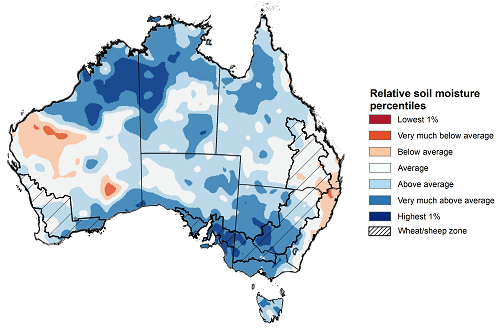
Source: Bureau of Meteorology (Australian Water Resources Assessment Landscape model)
Lower layer soil moisture for November 2022 was well above average to extremely high for this time of year across large parts of New South Wales, Queensland, Victoria, South Australia, as well as parts of southern and northern Western Australia and Northern Territory, and eastern Tasmania. Lower layer soil moisture was below average to extremely low in isolated parts of western and eastern Western Australia. Modelled lower layer soil moisture was generally average across the remainder of the country.
Lower layer soil moisture will be important to support summer crops and pasture growth during a peak growth period. In Australian cropping regions, lower layer soil moisture was above average to extremely high across most of New South Wales, Queensland, Victoria, South Australia, and southern Western Australia. Lower layer soil moisture was generally average across remaining cropping areas.
Well above average to extremely high lower layer soil moisture levels across New South Wales, Queensland and Victorian cropping regions present a potential downside risk to yields. These areas are expected to receive above median rainfall over the next three months, increasing the risk that saturated soils and waterlogging will persist and reduce yield potentials. High lower layer soil moisture levels during November also provide a reserve of plant-available water for summer crops later in the growing season.
Modelled lower layer soil moisture for November 2022
Source: Bureau of Meteorology (Australian Water Resources Assessment Landscape model)
Over the 8-days to 8 December 2022, high-pressure systems are forecast to bring dry condition to much of Australia. Meanwhile, low-pressure systems and a broad trough is forecast to bring moderate to heavy rainfall to eastern Queensland. Low-pressure systems and frontal activity are forecast to bring moderate rainfall to eastern New South Wales, south-eastern Victoria and Tasmania.
In Australian cropping regions, rainfall totals of between 10 to 50 millimetres are expected across eastern and central Queensland and isolated areas of south-eastern Western Australia. Little to no rainfall is forecast for remaining cropping regions during the next 8-days.
The easing of wet conditions across flood-affected cropping regions of eastern Australia will likely further allow floodwaters to recede and reduce the risk of waterlogging and reductions in yield potential. The forecast drier conditions are also expected to provide an opportunity for soils to drain and allow improved access to fields for harvest and planting activities. Little to no rainfall forecast across most cropping regions will provide favourable conditions for winter crop harvesting and summer crop planting following two relatively dry weeks.
Total forecast rainfall (mm) for the period 1 December to 8 December 2022
Note: This rainfall forecast is produced from computer models. As the model outputs are not altered by weather forecasters, it is important to check local forecasts and warnings issued by the Bureau of Meteorology.
Water
Water storages, water markets and water allocations - current week
The Tableau dashboard may not meet accessibility requirements. For information about the contents of these dashboards contact ABARES.
