Key issues
- During the week ending 13 January troughs and a cold front generated showers and thunderstorm activity across parts of northern and eastern Australia. Rainfall this week across summer cropping regions is likely to benefit the production and yield potential of dryland crops sown on variable soil moisture.
- 2020 was Australia’s fourth-warmest year on record and annual rainfall was close to average, nationally. The La Niña event declared in September 2020 influenced generally above average rainfall across eastern and northern Australia during spring and summer and an early northern rainfall onset.
- Favourable growing conditions during 2020, boosted the winter crop production forecast in Australia to 51.5 million tonnes, second only to the record high of 56.7 million tonnes in 2016–17. Favourable climatic conditions across northern and eastern Australia also saw pasture availability recover in 2020 after successive dry years. Herd and flock rebuilding increased domestic demand for cattle and sheep.
- In summer cropping regions, December rainfall was generally average across Queensland and above average to highest on record in New South Wales. Following low November rainfall totals, this substantial December rainfall was favourable for summer crop planting and supported crop growth. Significant December rainfall across most of northern Australia provided conditions for above average pasture production and increased incentives for livestock restocking.
- A La Niña event is ongoing in the tropical Pacific. An early northern rainfall onset and the enhanced probabilities of a wetter than average summer rainfall will likely continue to benefit pasture growth across eastern and northern Australia and summer crop production.
- There is a high chance that rainfall between February and April 2021 will be sufficient to sustain close to average crop and pasture production through the summer period. These highly probable rainfall totals – if realised – represent favourable growing conditions for the 2020–21 summer cropping season and wet season across northern Australia. With average upper layer soil moisture levels and variable lower layer soil moisture levels across Queensland cropping regions, the development and production potential of dryland summer crops in these areas will be highly dependent on in-season rainfall.
- Over the next eight days, troughs and frontal activity are expected to generate showers and storms over parts of northern and eastern Australia. In Australia’s summer cropping regions, rainfall of between 10 and 50 millimetres is expected across parts of north-eastern New South Wales and most Queensland cropping regions. Little to no rainfall is expected across remaining summer cropping regions during the next eight days.
- Water storage levels in the Murray-Darling Basin (MDB) decreased by 102 gigalitres (GL) between 6 January 2021 and 12 January 2021. The current volume of water held in storage is 14,151 GL, which represents 56% of total capacity.
- Allocation prices in the Victorian Murray below the Barmah Choke decreased from $205 per ML to $165 per ML between 17 December 2020 and 14 January 2021. Prices are lower in the Goulburn-Broken, Murrumbidgee and regions above the Barmah Choke, due to binding of the Goulburn intervalley trade and Murrumbidgee export limits, and the Barmah Choke trade constraint.
Climate
[expand all]
Rainfall this week
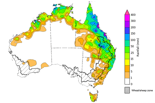
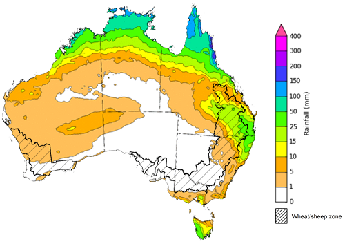
During the week ending 13 January 2021 troughs and a cold front generated showers and thunderstorm activity across parts of northern and eastern Australia.
Rainfall totals of between 15 and 100 millimetres were recorded across much of Queensland and parts of north-eastern New South Wales, northern Western Australia, the north of the Northern Territory and western Tasmania. Rainfall totals in excess of 100 millimetres were recorded across isolated parts of eastern and northern Queensland, northern Western Australia and the north of the Northern Territory.
In Australia’s summer cropping regions, rainfall totals of between 5 and 50 millimetres were recorded across parts of northern New South Wales and southern Queensland. Rainfall totals greater than 50 millimetres were recorded across cropping regions in central and northern Queensland during the week ending 13 January 2021.
Rainfall across summer cropping regions during the week ending 13 January 2021 is likely to benefit the production and yield potential of dryland crops sown on variable soil moisture.
Rainfall for the week ending 13 January 2021
©Commonwealth of Australia 2020, Australian Bureau of Meteorology - Issued: 13/01/2021
Note: The rainfall analyses and associated maps utilise data contained in the Bureau of Meteorology climate database, the Australian Data Archive for Meteorology (ADAM). The analyses are initially produced automatically from real-time data with limited quality control. They are intended to provide a general overview of rainfall across Australia as quickly as possible after the observations are received. For further information go to http://www.bom.gov.au/climate/rainfall/
2020 Climate Wrap
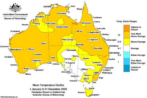
The annual climate statement, released by the Bureau of Meteorology on 8 January 2021, reports that 2020 was Australia’s fourth-warmest year on record and annual rainfall was close to average nationally. The annual national mean temperature was 1.15°C above the 1961–1990 average, with widespread and persistent warmth across Australia during the year. The annual national average rainfall was 483.4 millimetres, 4% above the 1961–1990 average.
Annual mean temperatures for 2020 were above to very much above average for the majority of Australia. They were warmest on record for isolated parts of north-western Queensland and north-western Western Australia, and average for parts of western and central New South Wales, western Victoria and the eastern half of South Australia.
Mean temperature deciles, January to December 2020
©Commonwealth of Australia 2020, Australian Bureau of Meteorology - Issued: 02/01/2021
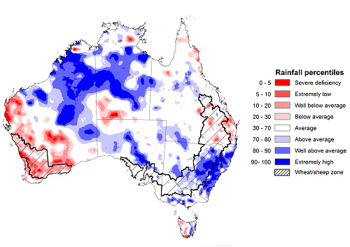
Following Australia’s driest year on record, rainfall was average to above average for much of Australia from January to March 2020 and rainfall in April 2020 was above average for much of south-eastern Australia. Rainfall from May to July was below average across much of the southern half of Australia. Much of Australia recorded average to extremely high rainfall from August to October as a La Niña event developed. This rainfall supported average to above average pasture and crop growth across south-eastern Australia.
Annual rainfall was above average for much of New South Wales, northern and eastern Western Australia and the Northern Territory, and parts of central Victoria, southern South Australia, eastern Tasmania and isolated parts of Queensland. Annual rainfall was below average for much of the west of Western Australia and parts of eastern Queensland, western Tasmania and the north and south of the Northern Territory.
In 2020–21 the gross value of agricultural production is forecast to rise by 7% to $65 billion (see Agricultural Commodities Report – December 2020 edition). Increased gross value of agricultural production is largely a result of improved cropping outcomes.
Favourable growing conditions during 2020 boosted the winter crop production forecast in Australia to 51.5 million tonnes, second only to the record high of 56.7 million tonnes in 2016–17. Production is expected to be a record high in New South Wales and the second highest on record in Victoria (see Australian crop report). Favourable climatic conditions across northern and eastern Australia saw pasture availability recover in 2020 after successive dry years. Herd and flock rebuilding increased domestic demand for cattle and sheep. Competition from feedlots and farmers seeking to restock in eastern Australia pushing up prices for young cattle, which saw the Eastern Young Cattle Indicator exceeded 800 cents/kg for the first time, in October 2020.
The Bureau of Meteorology report that the main natural climate driver that influenced Australia during 2020 was the El Niño–Southern Oscillation that started moving towards the La Niña phase in winter and the event was officially declared in September. The La Niña event influenced generally above average rainfall across eastern and northern Australia during spring and summer and an early northern rainfall onset. In addition, sea surface temperatures in the Indian Ocean reflected negative Indian Ocean Dipole-like patterns during late winter and early spring, influencing above average rainfall across eastern and southern Australia. Further information at: http://www.bom.gov.au/climate/current/annual/aus/
Rainfall percentiles, January to December 2020
©Commonwealth of Australia 2020, Australian Bureau of Meteorology - Issued: 02/01/2021
Monthly temperatures
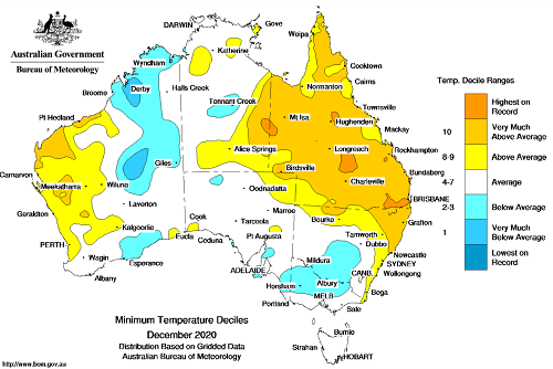
December 2020 was warmer than average nationally with a national mean temperature of 0.14°C above average.
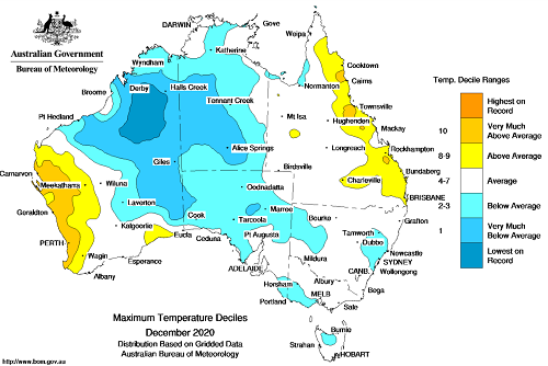
Maximum temperatures for December were lowest on record to below average across large parts of north-western and central Australia due to tropical lows during the month. Maximum and minimum temperatures were above average to very much above average across parts of western and north-Australia. Across eastern Australia, very much above average to average temperatures coupled with substantial rainfall are likely to have benefitted production prospects of dryland summer crops.
Maximum temperature deciles for December 2020
©Commonwealth of Australia 2020, Australian Bureau of Meteorology - Issued: 03/01/2021
Minimum temperature deciles for December 2020
©Commonwealth of Australia 2020, Australian Bureau of Meteorology - Issued: 03/01/2021
Note: Maximum and minimum temperatures for December 2020 compared with temperature recorded for that period during the historical record (1900 to present). For further information go to: http://www.bom.gov.au/water.
Monthly rainfall
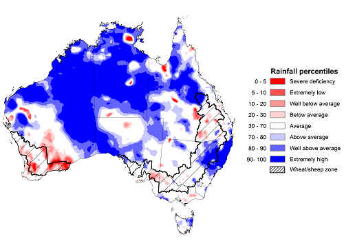
December 2020 rainfall was the fourth highest on record for the month nationally. Rainfall was above average to highest on record across much of northern Australia and parts of central-southern and south-eastern Australia. La Niña remained at moderate levels in December and the Southern Annular Mode (SAM) was positive through much of December. During summer, La Niña and a positive SAM typically increase the chance of rainfall in northern and eastern Australia. The Australian monsoon onset date was the 19 December for the 2020–21 northern wet season, more than a week earlier than average and a month earlier than last season’s onset date.
In summer cropping regions, December rainfall was generally average across Queensland and above average to highest on record in New South Wales. Following low November rainfall totals, this substantial December rainfall likely increased farmer’s summer crop planting confidence and supported crop growth. In areas of Queensland with low soil moisture, farmers planting intentions and favourable summer crop growth will rely on the above average rainfall outlook for the remainder of the growing season being realised. Significant December rainfall across most of northern Australia likely supported above average pasture production and increased livestock restocking confidence.
Rainfall percentiles for December 2020
Source: Bureau of Meteorology
Note: Rainfall for December 2020 is compared with rainfall recorded for that period during the historical record (1900 to present). For further information, go to http://www.bom.gov.au/water/
Monthly soil moisture
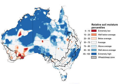
Upper layer soil moisture in December 2020 was above average to highest on record for this time of year across much of northern Australia and parts of central-southern and south-eastern Australia, largely reflecting rainfall patterns during the month. Modelled soil moisture was well below average to below average across parts of southern Western Australia. Upper layer soil moisture is important at the beginning of the summer cropping season since plant germination and establishment is highly dependent on the moisture in this top 10 cm of the soil profile.
Relative upper layer soil moisture was above average to very much above average for this time of year across cropping regions in northern New South Wales and far southern Queensland. Soil moisture was average across remaining cropping regions in Queensland and New South Wales.
Modelled upper layer soil moisture for December 2020
Source: Bureau of Meteorology (Australian Water Resources Assessment Landscape model)
Note: This map shows the levels of modelled upper layer soil moisture (0 to 10 centimetres) during December 2020. This map shows how modelled soil conditions during December 2020 compare with December conditions modelled over the reference period (1911 to 2016). Dark blue areas on the maps were much wetter in December 2020 than during the reference period. The dark red areas were much drier than during the reference period. The bulk of plant roots occur in the top 20 centimetres of the soil profile. Soil moisture in the upper layer of the soil profile is therefore useful indicator of the availability of water, particularly for germinating seed.
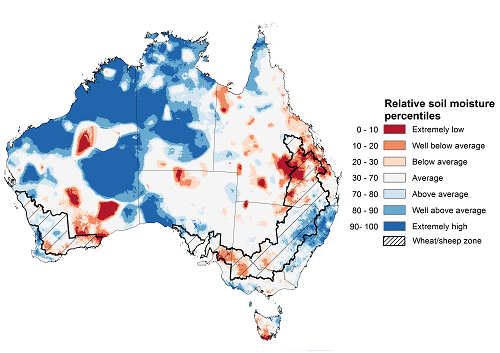
Lower layer soil moisture for December 2020 was above average to extremely high for this time of year across parts of northern, western and south-eastern Australia. Soil moisture was very much below average to below average across parts of southern Queensland and southern Western Australia.
In summer cropping regions, lower layer soil moisture was average to well above average for much of New South Wales. Soil moisture was well below average to average across most Queensland cropping regions.
Modelled lower layer soil moisture for December 2020
Source: Bureau of Meteorology (Australian Water Resources Assessment Landscape model)
Note: This map shows the levels of modelled lower layer soil moisture (10 to 100 centimetres) during December 2020. This map shows how modelled soil conditions during December 2020 compare with November conditions modelled over the reference period (1911 to 2016). Dark blue areas on the maps were much wetter in December 2020 than during the reference period. The dark red areas were much drier than during the reference period. The bulk of plant roots occur in the top 20 centimetres of the soil profile. The lower layer soil moisture is a larger, deeper store that is slower to respond to rainfall and tends to reflect accumulated rainfall events over longer time periods.
Climate Drivers
As the generally favourable summer cropping and northern pasture production season continues, interest moves to the prospects at the end of the summer and the start of the winter cropping season in autumn. To gain some insight it is important to look at the climate drivers—the El Nino Southern Oscillation (ENSO), the Southern Annular Mode (SAM) and the Madden–Julian Oscillation (MJO)—that can influence summer and autumn rainfall across southern Australia.
A La Niña is ongoing in the tropical Pacific. A La Niña during summer is likely to generate the favourable growing conditions for summer crop and pasture production that were central in developing ABARES summer crop and livestock production forecasts embodied in the ABARES December 2020 editions of the Australian crop report and Agricultural commodities. An early northern rainfall onset and the enhanced probabilities of a wetter than average summer rainfall will likely continue to benefit pasture growth across eastern and northern Australia and summer crop production.
The IOD is neutral and expected to remain neutral through summer. IOD events do not form between December and April due to the progression of the Australian monsoon.
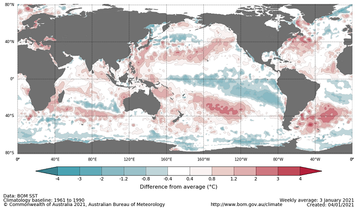
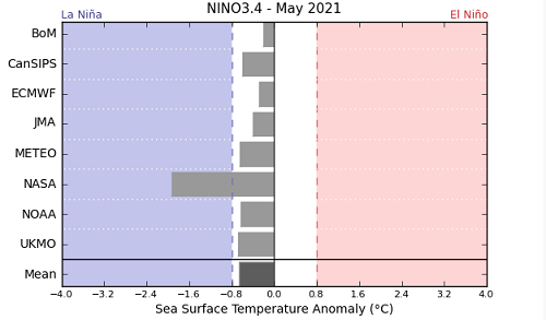
Cool anomalies in the central and eastern Pacific Ocean remain a similar strength to the past fortnight. As at 5 January 2021 all but one of the international climate models surveyed suggest the La Niña is likely at its peak and will return to neutral by the end of May 2021. Typical La Niña impacts are likely to continue as the event starts to weaken.
Difference from average sea surface temperature observations 28 December 2020 to 3 January 2021
International climate model outlooks for the NINO 3.4 region in May 2021
©Commonwealth of Australia 2020, Australian Bureau of Meteorology - Issued: 03/01/2021
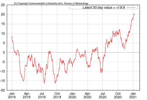
Atmospheric indicators are generally consistent with a La Niña event, with stronger than average trade winds and decreased cloudiness near the Date Line. The MJO and monsoon trough have likely contributed to the recent increase in Southern Oscillation Index (SOI) values and the SOI values remain consistent with a La Niña event. For the period ending 10 January the 30-day SOI value was 19.9 and for the period ending 3 January the 90-day value was 11.8.
30-day Southern Oscillation Index (SOI) values ending 10 January 2021
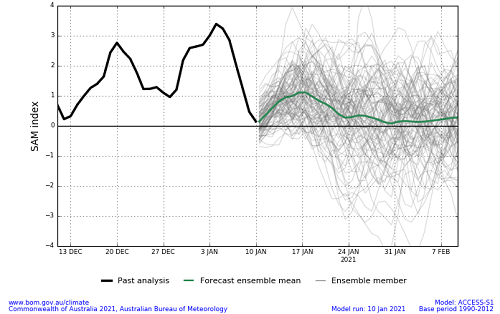
The Southern Annular Mode (SAM) is currently weakly positive and expected to be positive until at least the end of January 2021. The SAM refers to the north-south shift of the band of rain-bearing westerly winds and weather systems in the Southern Ocean compared to the usual position. When SAM is positive during spring and summer, the band of westerly winds is further south than normal. This allows for increased moist onshore flow from the Tasman and Coral seas and more rainfall across eastern Australia and a reduced chance of extreme heat. A positive SAM is common in spring and summer during La Niña events and can enhance the wetter than average influence La Niña has on eastern Australia.
Southern Annular Mode (SAM) daily index
National Climate Outlook
These climate outlooks are generated by ACCESS–S (Australian Community Climate Earth-System Simulator–Seasonal). ACCESS–S is the Bureau of Meteorology's dynamical (physics-based) weather and climate model used for monthly, seasonal and longer-lead climate outlooks.
For further information, go to http://www.bom.gov.au/climate/ahead/about/
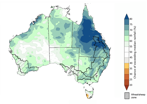
The latest rainfall outlook released by the Bureau of Meteorology suggests above average rainfall is more likely for much of northern and eastern Australia during February 2021. There is greater than 65% chance of above average rainfall across much of north-eastern Australia and parts of north-western and south-eastern Australia.
The rainfall outlook for February to April 2021 suggests that wetter than average conditions are likely for much of Australia. There is greater than 70% chance of above average rainfall across much of Queensland and greater than 65% chance of above average rainfall across parts of New South Wales, Victoria, north-eastern South Australia, northern and southern Western Australia and the Northern Territory (Bureau of Meteorology ‘National Climate Outlook’, 7 January 2020). Bureau of Meteorology rainfall outlooks for February to April have greater than 55% past accuracy across most of Australia excluding south-western Western Australia and isolated areas scattered across the eastern two-thirds of Australia.
Chance of exceeding the median rainfall February 2020 to April 2021
©Commonwealth of Australia 2020, Australian Bureau of Meteorology - Issued: 07/01/2021
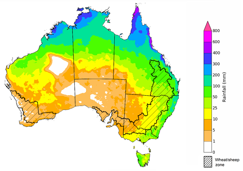
The outlook for February 2021 suggests that there is a 75% chance of rainfall totals between 25 and 100 millimetres across much of northern Australia and parts of eastern Australia. There is a 75% chance of rainfall totals between 1 and 25 millimetres across much of southern and south-western Australia. Rainfall totals in excess of 100 millimetres are likely across the tropical north and parts of the eastern coast of Australia.
There is a high chance of recording close to average February rainfall totals across much of northern Australia and cropping regions in northern Queensland and if realised, these totals are likely to support average pasture growth potentials in northern Australia and the final stages of growth of summer crops in northern Queensland. Across summer cropping regions in southern Queensland and New South Wales there is a 50% chance of recording close to average February rainfall. In areas with average or better levels of soil moisture these totals are likely to be sufficient to support close to average crop and pasture production.
In summer cropping regions there is a 75% chance of rainfall totals between 10 and 50 millimetres across much of New South Wales and between 25 and 100 millimetres across much of Queensland. Most southern cropping regions are seasonally dry at this time of year, meaning that little to no crop growth in these areas during the summer months.
Rainfall totals that have a 75% chance of occurring February 2021
©Commonwealth of Australia 2020, Australian Bureau of Meteorology - Issued: 07/01/2021
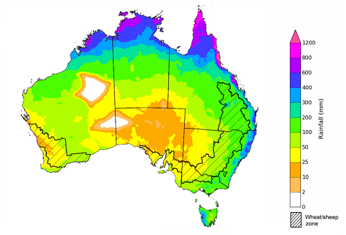
The outlook for February 2020 to April 2021 suggests that there is a 75% chance of rainfall totals between 25 and 200 millimetres across much of the southern two thirds of Australia. Lower rainfall totals between 10 and 25 millimetres are likely across parts of the central-south and south-west of Australia. Rainfall totals in excess of 200 millimetres are likely across the tropical north, much of the eastern coastline of Australia and parts of western Tasmania.
There is a high chance of recording February to April rainfall totals sufficient to sustain close to average crop and pasture production through the summer period. With average or better levels of upper and lower layer soil moisture across New South Wales cropping regions, these close to average totals are likely to support average pasture growth potentials, the final stages of growth of summer crops and the possible early planting of winter forage crops. With average upper layer soil moisture levels and variable lower layer soil moisture levels across Queensland cropping regions, the development and potential production of dryland summer crops will highly dependent on the rainfall totals received in the coming three month period.
Across cropping regions, there is a 75% chance of receiving between 50 and 200 millimetres across most of New South Wales and Queensland, with lower totals between 25 and 50 millimetres across south-western New South Wales cropping regions up between February and April 2021. There is a 75% chance of receiving between 25 and 100 millimetres across most cropping regions in Victoria, South Australia and Western Australia between February and April 2021.
These high chance rainfall totals are almost equivalent to the seasonal median (between 1990 and 2012) and if realised represent favourable growing conditions for the 2020–21 summer cropping season in eastern Australia and wet season across northern Australia.
Rainfall totals that have a 75% chance of occurring February to April 2021
©Commonwealth of Australia 2020, Australian Bureau of Meteorology - Issued: 07/01/2021
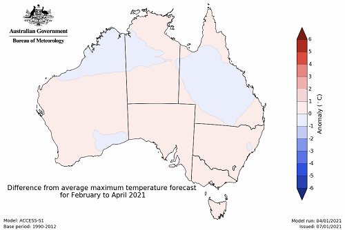
The temperature outlook for February to April 2021 indicates that night-time temperatures are likely to be between 1°C to 2°C above the 1990-2012 average across parts of south-eastern Australia. Day-time temperatures across Australia and night-time temperatures across the remainder of Australia are likely to be close to the 1990-2012 average (- 1°C to 1°C) (Bureau of Meteorology ‘National Climate Outlook’, 7 January 2020).
Predicted maximum temperature anomaly for February to April 2021
Predicted minimum temperature anomaly for February to April 2021
Rainfall forecast for the next 8 days
Troughs and frontal activity are expected to generate showers and storms over parts of northern and eastern Australia during the next eight days.
Rainfall totals of between 10 and 50 millimetres are forecast for parts of north-eastern New South Wales, northern and south-eastern Queensland, scattered areas of Victoria, northern Western Australia, the north of the Northern Territory and Tasmania. Rainfall totals in excess of 50 millimetres is expected across parts of northern Western Australia, north of the Northern Territory, and northern Queensland.
In Australia’s summer cropping regions, rainfall of between 10 and 50 millimetres is expected across parts of north-eastern New South Wales and most Queensland cropping regions. Little to no rainfall is expected across remaining summer cropping regions during the next eight days.
Total forecast rainfall (mm) for the period 14 January to 21 January 2021
©Commonwealth of Australia 2020, Australian Bureau of Meteorology - Issued: 14/01/2021
Note: This rainfall forecast is produced from computer models. As the model outputs are not altered by weather forecasters, it is important to check local forecasts and warnings issued by the Bureau of Meteorology.
Commodities
Information on weekly price changes in agricultural commodities is now available at the Weekly commodity price update.
Water
Water storages, water markets and water allocations - current week
The Tableau dashboard may not meet accessibility requirements. For information about the contents of these dashboards contact ABARES.

