
Key issues
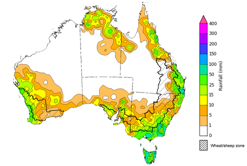
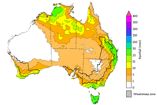
- During the week ending 20 October 2021, low-pressure troughs dominated the Australian continent resulting in rainfall across northern parts of Australia. Meanwhile, cold fronts coming off the Southern Ocean brought substantial rainfall to the south-west, south-east and Tasmania.
- As at 28 September 2021 global production conditions were generally favourable for the production of corn, rice and soybean. However, a lack of precipitation has affected the production potential of wheat in some key grain exporting and importing countries.
- In the northern hemisphere, precipitation was below average across much of central Canada, the southern United States and central Europe. Precipitation was above average for parts of western Europe, eastern China and the west of the Russian Federation. In the southern hemisphere, September precipitation was below average across parts of southern Argentina and southern Brazil. Precipitation was generally average across the remainder of major grain-producing and oilseed-producing regions in the southern hemisphere.
- In the northern hemisphere production conditions for wheat have been mixed. Dryness has persisted across Canada, northern United States and key growing regions in the south of the Russian Federation. In other major growing regions of northern Argentina and Ukraine, as well as parts of China and the European Union, conditions have been favourable.
- The 2021–22 tropical cyclone outlook is influenced by the current La Niña event and associated ocean temperatures that are expected to persist until early 2021. It is expected that there will be an average to slightly above average number of tropical cyclones and tropical lows during the 2021–22 season.
- Over the 8-days to 28 October 2021 a trough of low-pressure extending across northern and eastern Australia is expected to bring rainfall to parts of the tropical north, south-east Queensland and north-east New South Wales. Meanwhile, troughs and cold fronts off the Southern Ocean are anticipated to result in rainfall for Victoria, Tasmania and southern parts of Western Australia over the next 8 days.
- Water storage in the Murray–Darling Basin (MDB) increased by 199 gigalitres (GL) between 13 October 2021 and 20 October 2021. The current volume of water held in storage is 22,013 GL, which represents 87% of total capacity. This is 45% or 6,876 GL more than at the same time last year.
- Allocation prices in the Victorian Murray below the Barmah Choke decreased from $152 per ML on 8 October 2021 to $119 per ML on 15 October 2021. Prices are lower in the Goulburn-Broken, Murrumbidgee, and regions above the Barmah choke due to the binding of the Goulburn intervalley trade limit, Murrumbidgee export limit, and Barmah choke trade constraint.
Climate
[expand all]
Rainfall this week
During the week ending 20 October 2021, low-pressure troughs dominated the Australian continent resulting in rainfall across northern parts of Australia. Meanwhile, cold fronts coming off the Southern Ocean brought substantial rainfall to the south-west, south-east and Tasmania.
Rainfall totals of between 10 and 50 millimetres were recorded in south-eastern and north-eastern New South Wales, parts of eastern Queensland, central and eastern Victoria, parts of southern South Australia, the west of Western Australia and the north of the Northern Territory. Rainfall totals in excess of 50 millimetres were recorded in south-east New South Wales, south-east Queensland, eastern Victoria and much of Tasmania.
In cropping regions, rainfall totals of between 10 and 50 millimetres were recorded in southern New South Wales, eastern Queensland, central and eastern Victoria, central and western areas of South Australia and the west of Western Australia. Little to no rainfall was recorded across remaining cropping regions.
The relatively dry conditions across Queensland and northern New South Wales cropping regions have likely allowed harvesting activities to resume, after some heavy rainfall the previous week. Likewise, summer planting in Queensland is well underway, encouraged by above average soil moisture levels in parts. The rainfall is south-eastern cropping regions will be a welcome top up to soil moisture levels and will support yield potentials through grain filling. In South Australia, soil moisture levels are below average to average due to a relatively dry spring thus far. The recent rainfall in parts of South Australia will provide some limited support for crops during grain filling, with more needed before the critical grain filling window closes.
Rainfall for the week ending 20 October 2021
©Commonwealth of Australia 2021, Australian Bureau of Meteorology - Issued: 20/10/2021
Note: The rainfall analyses and associated maps utilise data contained in the Bureau of Meteorology climate database, the Australian Data Archive for Meteorology (ADAM). The analyses are initially produced automatically from real-time data with limited quality control. They are intended to provide a general overview of rainfall across Australia as quickly as possible after the observations are received. For further information go to http://www.bom.gov.au/climate/rainfall/
Global production conditions and climate outlook
Crop production is affected by long-term trends in average rainfall and temperature, interannual climate variability, shocks during specific growth stages, and extreme weather events (IPCC 2012). Some crops are more tolerant than others to certain types of stresses, and at each growth stage, different types of stresses affect each crop species in different ways.
The precipitation anomalies and outlooks presented here give an indication of the current and future state of production conditions for the major grain and oilseed producing countries which are responsible for over 80% of global production. This is an important input to assessing the global grain supply outlook.
September precipitation percentiles and current production conditions
As of the end of September 2021, rainfall was mixed for the world’s major grain-producing and oilseed-producing regions.
In the northern hemisphere, precipitation was below average across much of central Canada, the southern United States and central Europe. Precipitation was above average for parts of western Europe, eastern China and the west of the Russian Federation. Precipitation was close to average across the remainder of major grain-producing and oilseed-producing regions in the northern hemisphere.
In the southern hemisphere, September precipitation was below average across parts of southern Argentina and southern Brazil. Precipitation was generally average across the remainder of major grain-producing and oilseed-producing regions in the southern hemisphere.
Global precipitation percentiles, September 2021
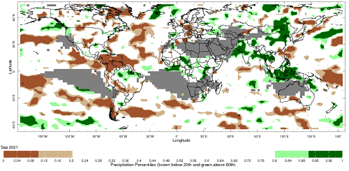
Note: The world precipitation percentiles indicate a ranking of precipitation for September, with the driest (0th percentile) being 0 on the scale and the wettest (100th percentile) being 1 on the scale. Percentiles are based on precipitation estimates from the NOAA Climate Prediction Center's Climate Anomaly Monitoring System Outgoing Precipitation Index dataset. Precipitation estimates for September 2021 are compared with rainfall recorded for that period during the 1981 to 2010 base period.
Source: International Research Institute for Climate and Society
As at 28 September 2021 global production conditions were generally favourable for the production of corn, rice and soybean. However, a lack of precipitation affected the production potential of wheat in some key grain exporting and importing countries.
In the northern hemisphere production conditions for wheat have been mixed. Dryness has persisted across Canada, northern United States and key growing regions in the south of the Russian Federation. With spring wheat harvesting complete, these dry conditions have resulted in below average yields. Meanwhile, winter wheat planting is well underway across these 3 key growing regions with dry conditions causing concern across growing regions in Canada and the Russian Federation, while some rainfall across the United States has benefitted planting activities. In other major growing regions of northern Argentina and Ukraine, as well as parts of China and the European Union, conditions have been favourable. For major production areas in China, Europe and India, wheat is currently out of season.
Conditions for corn were favourable for crop development in Argentina, Canada, China, much of the European Union, India, Mexico, the Russian Federation, Ukraine and much of the US. Dry conditions and periods of frost have negatively impacted summer-planted corn in Brazil. However, corn crops across parts of north-western US and Europe have also been negatively impacted by dry conditions. Harvesting activities have concluded or are ongoing in most major growing regions.
Conditions for rice were favourable for crop development in most growing regions, with harvesting underway in China, India, Indonesia, the Philippines, southern Vietnam and the US. Wet season rice in Thailand and northern Vietnam have reached panicle forming stage under favourable conditions.
Production conditions for soybeans are largely favourable across current growing regions, in Canada, China, India and the United States. However, dry conditions in central Canada and northern US states have negatively impacted yields. Harvesting is underway across all regions.
Crop conditions, AMIS countries, 28 September 2021
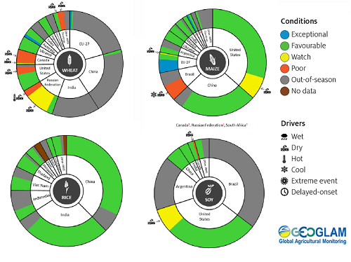
AMIS Agricultural Market Information System.
Source: AMIS
The global climate outlook for November 2021 to January 2022 indicates that mixed rainfall conditions are expected for the world's major grain-producing and oilseed-producing regions. Outlooks and potential production impacts for the major grain and oilseed producing countries are presented in the table.
Rainfall outlook and potential impact on the future state of production conditions between October and December 2021
| Region | October-December rainfall outlook | Potential impact on production |
|---|---|---|
| Argentina | Below average rainfall is expected across most of Argentina between November 2021 to January 2022. | Below average rainfall is likely to adversely affect the flowering and grain filling of corn and soybeans, as well as the planting of sorghum and millet. Over the coming months, cotton, groundnuts, millet, rice, sorghum, sunflower crops will be progressing through vegetative stages. The dry conditions are likely to negatively impact yield potentials for these crops. |
| Black Sea Region | There is no strong tendency towards either above or below average rainfall between November 2021 to January 2022. | Winter wheat and canola will enter dormancy in November and remain dormant over the following months. The average rainfall conditions are likely to provide sufficient snowpack to precent winterkill from freezing temperatures. |
| Brazil | Above average rainfall is more likely in northern Brazil and parts of the central west, while below average rainfall is more likely across the south of Brazil between November 2021 to January 2022. | Below average rainfall in parts of southern Brazil will provide favourable conditions for harvesting of wheat in November. However, below average rainfall is likely to adversely affect flowering of corn and soybeans in December, as well as cotton and groundnut flowering for southern growing regions in January. In the central west, flowering of soybean is likely to be adversely impacted by dry conditions in parts but may benefit from above average rainfall in other parts. |
| Canada | There is no strong tendency towards above or below average rainfall across much of central Canada between November 2021 to January 2022. However, above average rainfall is forecast for parts of southern Ontario. | Above average rainfall in some eastern growing regions will likely interrupt harvesting of corn, soybeans and sunflowers. Through December and January, winter wheat and canola will remain dormant, with average rainfall likely to provide sufficient snowpack to prevent winterkill of winter wheat. |
| China | Above average rainfall is likely across much of northern China and below average rainfall is expected across south-western and south-eastern China between November 2021 to January 2022. | Above average rainfall in southern and eastern China is likely to impede the harvesting of cotton, corn, sorghum, soybean, sunflower, groundnuts and single rice. Above average rainfall will likely provide sufficient snowpack for winter wheat and canola as they enter dormancy in December. In south-western and south-eastern China, below average rainfall will support harvesting activities. |
| Europe | Below average rainfall is more likely for isolated parts of northern Europe, while above average rainfall is expected for isolated parts of western Europe between November 2021 to January 2022. Rainfall is expected to be close to average across much of Europe. | Average rainfall conditions across much of Europe is likely to benefit the planting of canola and winter wheat in November, as well as providing sufficient snowpack to prevent winterkill in December and January. |
| South Asia (India) | Average to above average rainfall is likely across much of southern and central India. However, below average rainfall is expected in parts of northern India between November 2021 to January 2022. | Average to above average rainfall is likely to impede harvesting of corn, groundnuts, millet, rice, sorghum, and sunflower in southern and central parts of India. Below average rainfall in parts of northern India is likely to negatively impact the planting and vegetative growth of winter wheat and canola between November and January. |
| Southeast Asia (SEA) | Above average rainfall is likely across much of SEA between November 2021 to January 2022. | Above average rainfall in SEA is likely to impede corn, groundnut and soybean harvesting in November. |
| The United States of America | Above average rainfall is more likely for the north-western and north-eastern US, while below average rainfall is more likely across much of the southern half of the US. | Average to above average rainfall across the mid-west US may impede the harvesting of corn and soybean in November. While average to below average rainfall in central and southern parts of the US is likely to support harvesting of sorghum. The average rainfall conditions expected across the northern US is likely to support establishment and growth of canola and winter wheat, as well as providing sufficient snow cover in December and January. |
Tropical Cyclone Outlook
Tropical cyclones and tropical lows can cause damaging winds, widespread rainfall and flooding in northern Australia, and their impacts can also extend into southern Australia. Increased rainfall, soil moisture and water storage in northern Australia may benefit pasture and summer crop development, however widespread flooding and severe weather can also adversely impact crop and livestock development.
The tropical cyclone season in the Australian region extends from 1 November to 30 April and the influence of climate drivers cause large variability in tropical cyclone activity each season. This outlook was developed by the Bureau of Meteorology using the July, August and September Southern Oscillation Index (SOI) and sea surface temperate anomalies in the central Pacific (NINO3.4 values). Since 2000, the average number of tropical cyclones each season in the Australian region has been nine, and four of these typically cross the coast of Australia. The long-term average number of tropical cyclones each season is 11 (since 1969‑70), and there has been a decline in the average number of tropical cyclones forming in the Australian region during recent decades which is consistent with the expected impacts of climate change.
The 2021–22 tropical cyclone outlook is influenced by the increased likelihood of La Niña development in the tropical Pacific Ocean and average to warmer-than-average sea surface temperatures to the north of Australia. It is expected that there will be an average to slightly above average number of tropical cyclones and tropical lows during the 2021–22 season. There is a 65% chance of more than 11 tropical cyclones developing in the Australian region. During La Niña years the first tropical cyclone to develop in the Australia region typically occurs in mid-December.
Chance of more tropical cyclones than average during the 2021–22 season
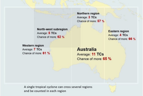
© Australian Bureau of Meteorology
Note: This map shows the average number of tropical cyclones in the Australian region and the chance (as a percentage) of a higher than average number of tropical during the 2021–22 season using data based on a 48 year period from 1969‑70 to 2019‑20 tropical cyclone season and is based on the status of the El Niño–Southern Oscillation (ENSO) over the preceding July to September.
Rainfall forecast for the next eight days
Over the 8-days to 28 October 2021 a trough of low-pressure extending across northern and eastern Australia is expected to bring rainfall to parts of the tropical north, and south-east Queensland and north-east New South Wales. Meanwhile, troughs and cold fronts off the Southern Ocean are anticipated to result in rainfall for Victoria, Tasmania and southern parts of Western Australia over the next 8 days.
Rainfall totals of between 10 and 50 millimetres are forecast for north-eastern and south-eastern New South Wales, south-eastern and north-western Queensland, southern and eastern Victoria, the south-west and far north of Western Australia, the central and north of the Northern Territory and parts of Tasmania. Rainfall in excess of 50 millimetres is expected in parts of Tasmania.
In Australian cropping regions, rainfall totals of between 10 and 50 millimetres are expected in central and northern Queensland, and southern parts of Western Australia. Little to no rainfall is forecast for cropping regions in New South Wales, Victoria, South Australia and remaining parts of Queensland and Western Australia during the next 8-days.
The rainfall expected in central and northern Queensland will likely boost soil moisture levels, which are currently average to below average in parts, and assist the germination and establishment of early sown summer crops. The dry conditions forecast for southern Queensland and northern New South Wales will allow harvesting of winter crops to proceed unimpeded. Soil moisture levels remain average to above average across southern New South Wales, Victorian and some Western Australian cropping regions for this time of year. As a result, yield potentials remain strong as crops continue through grain filling. For South Australia, dry conditions are expected to continue, following a dry spring to-date. Yield potentials remain subdued.
Total forecast rainfall (mm) for the period 21 October to 28 October 2021
©Commonwealth of Australia 2021, Australian Bureau of Meteorology - Issued: 21/10/2021
Note: This rainfall forecast is produced from computer models. As the model outputs are not altered by weather forecasters, it is important to check local forecasts and warnings issued by the Bureau of Meteorology.
Water
Water storages, water markets and water allocations - current week
The Tableau dashboard may not meet accessibility requirements. For information about the contents of these dashboards contact ABARES.

Commodities
Information on weekly price changes in agricultural commodities is now available at the Weekly commodity price update.