
Key issues
- For the week ending 22 November 2023, severe thunderstorm activity resulted in showers and thunderstorms over northern, central, and eastern Australia.
- These falls are likely to have been sufficient to spark widespread sowing of dryland summer crops in Queensland and northern New South Wales.
- Over the coming week, troughs stretching from tropical north to southeast Australia covering much of northern and eastern Australia will generate widespread storms and showers of up to 100 millimetres.
- Further rainfall in Queensland and northern New South Wales cropping regions is likely to give some growers confidence to plant summer crops such as sorghum.
- Dry conditions in Western Australia should allow for the remaining harvest to continue without delay.
- A moderate strength El Niño and a strong positive IOD event are currently underway.
- Positive IOD is forecast to persist into December, and combined with El Niño, it will delay the onset of Australian monsoon.
- El Niño will remain active till early autumn 2024, which increases the likelihood of drier than average conditions for the north-east of Australia and warmer than average days across much of the eastern half of the country during summer.
- December to February rainfall for most of Australia’s cropping regions is expected to be close to average.
- Water storage levels in the Murray-Darling Basin (MDB) decreased between 16 November 2023 and 23 November 2023 by 133 gigalitres (GL). Current volume of water held in storage is 15 902 GL.
- Allocation prices in the Victorian Murray below the Barmah Choke decreased from $146 on 16 November 2023 to $121 on 23 November 2023. Prices are lower in the Goulburn-Broken due to the binding of the Goulburn intervalley trade limit.
Climate
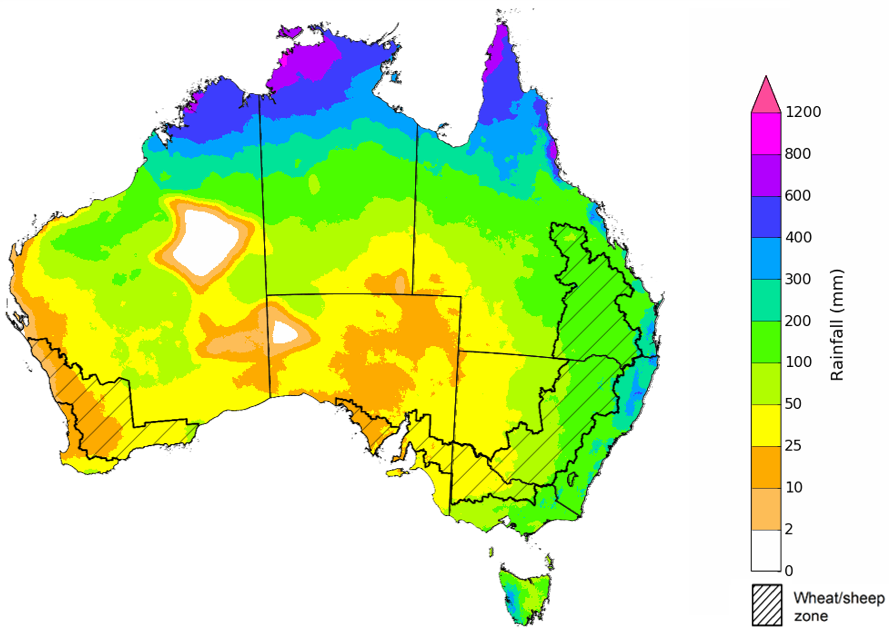
For the week ending 22 November 2023, severe thunderstorm activity brought rainfall of up to 150 millimetres of over parts of eastern Australia, while inland troughs brought falls of up to 100 millimetres to parts of central Australia.
Across cropping regions, rainfall totals of up to 150 millimetres were recorded in Queensland and up to 100 millimetres in northern New South Wales. These falls will have given confidence to some growers to plant dryland summer crops such as sorghum. Rainfall totals of up to 15 millimetres in southern New South Wales would have delayed harvest activity but it is unlikely that these falls have affected grain quality. Little to no rainfall recorded across remaining cropping areas this would have allowed for the uninterrupted harvest of the remaining winter crops.
Rainfall for the week ending 22 November 2023
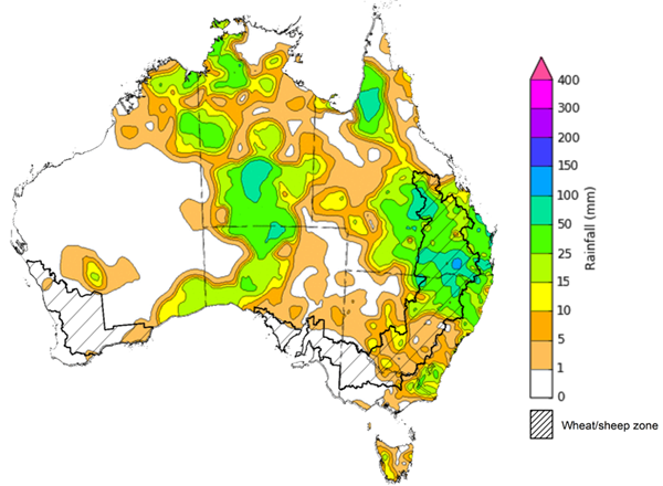
Issued: 22/11/2023
Note: The rainfall analyses and associated maps utilise data contained in the Bureau of Meteorology climate database, the Australian Data Archive for Meteorology (ADAM). The analyses are initially produced automatically from real-time data with limited quality control. They are intended to provide a general overview of rainfall across Australia as quickly as possible after the observations are received. For further information go to http://www.bom.gov.au/climate/rainfall/
Note: The rainfall analyses and associated maps utilise data contained in the Bureau of Meteorology climate database, the Australian Data Archive for Meteorology (ADAM). The analyses are initially produced automatically from real-time data with limited quality control. They are intended to provide a general overview of rainfall across Australia as quickly as possible after the observations are received. For further information go to http://www.bom.gov.au/climate/rainfall/
The climate drivers with the largest potential impact on Australia’s climate patterns are the El Niño–Southern Oscillation (ENSO), Madden-Julian Oscillation (MJO), Indian Ocean Dipole (IOD) and Southern Annular Mode (SAM). These climate drivers are likely to influence pasture growth across southern Australia and the growth and yield prospects for winter crops.
The SAM is currently in neutral phase and is forecast to remain neutral for next fortnight. During Spring, neutral SAM is associated with average climate conditions in southern Australia.
The MJO is forecast to be in the western Indian Ocean by the end of November and typically has a drying influence on northern and eastern Australia.
An El Niño and a positive IOD event are currently active with El Niño tracking as a moderate strength event while positive IOD as a strong event. When a positive IOD and El Niño occur together, their drying effect in spring is typically stronger and more widespread across Australia and warmer than average southern hemisphere. In summer, El Niño increases the likelihood of drier than average conditions for the north-east of Australia and warmer than average days across much of the eastern half of the country. The El Niño is expected to persist till early autumn 2024.
The IOD tends to break down as the monsoon trough moves south into the southern hemisphere, typically around the end of the southern hemisphere spring. Given the current strength of the positive IOD event, the break down this year is likely to be slightly later than usual. Additionally, during El Niño, the onset of the North Australian Monsoon tends to be delayed. The currently active positive IOD is expected to remain active till end of December 2023 and reduced rainfall is expected in central and southeast Australia, but with a lesser degree than that typically observed in spring.
ENSO and IOD forecast
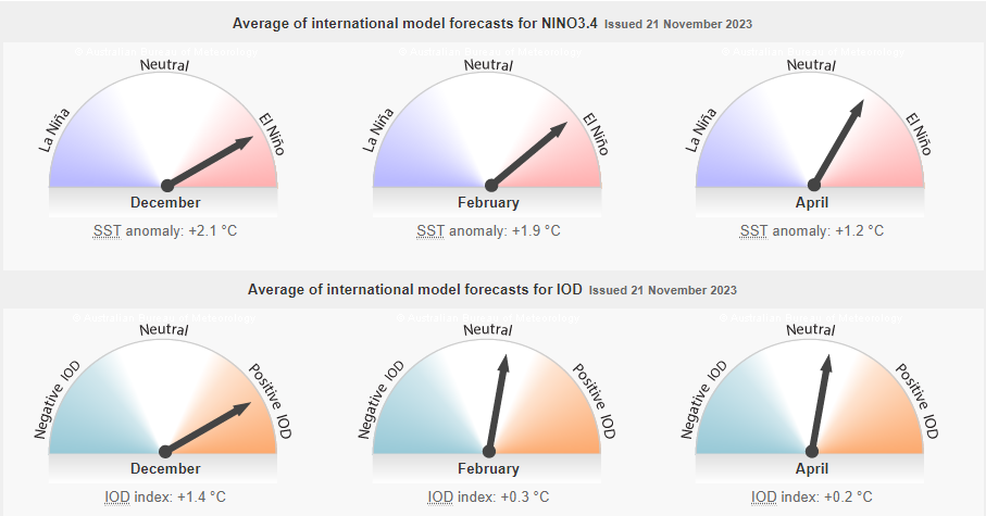
Issued: 21/11/2023
The Bureau of Meteorology’s latest rainfall outlook for December 2023 indicates that much of Australia there is a near equal chance of above or below average rainfall. However, below median rainfall is likely to very likely (60 to 80% chance) for the northern coastal regions of mainland Australia and Tasmania.
The Bureau of Meteorology’s climate model suggests that for December 2023, there is a 75% chance of rainfall totals between 10 and 100 millimetres across eastern New South Wales, northern and eastern Queensland, and southern Victoria. Rainfall totals in excess of 100 millimetres are expected across western Tasmania, northern Western Australia and Northern Territory.
Across cropping regions, there is a 75% chance of rainfall totals of between 10 and 50 millimetres in New South Wales and Queensland. December rainfall totals are expected to be below 25 millimetres for the remaining cropping regions.
Given the above average rainfall recorded across southern Queensland and north-eastern New South Wales during November, if realised these forecast rainfall totals for December will provide some useful follow-up falls for dry land summer crop production as well as pasture growth across.
Rainfall totals that have a 75% chance of occurring in December 2023
Issued: 23/11/2023
The rainfall outlook for December 2023 to February 2024 suggests that there is close to equal chances of above or below median rainfall for much of Australia, with exceptions being northern Queensland, coastal Western Australia and Northern Territory where below median rainfall is likely. This outlook is showing an improvement in the expected rainfall from that issued two weeks ago.
Across cropping regions, there is a close to equal chances of above or below median rainfall across most regions, except for northern Queensland cropping regions where below median rainfall is likely.
Chance of exceeding the median rainfall December 2023 to February 2024
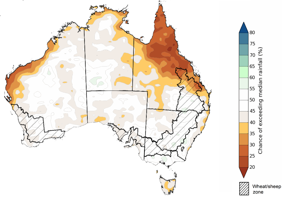
Issued: 23/11/2023
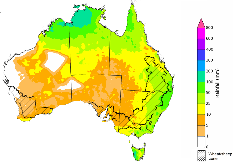
The outlook for December 2023 to February 2024 suggests there is a 75% chance of rainfall totals between 25 and 200 millimetres across much of Australia. The main exceptions being large areas of South Australia and western and central parts of Western Australia where below 25 millimetres of rainfall are expected. Rainfall totals in excess of 200 millimetres are expected across tropical northern Australia, coastal New South Wales and western Tasmania during this same period.
In cropping regions, there is a 75% chance of receiving between 50 and 200 millimetres across New South Wales, Queensland and eastern Victoria while less than 50 millimetres of rainfall are likely across remaining cropping regions.
If these falls are realised, it is likely to be sufficient to support summer pasture growth across eastern and northern Australia. While the dry start to spring has limited the early planting of summer crops, if realised these forecast falls may be sufficient to support the establishment and growth of crops planted at the end of spring and allow for the additional planting of summer crops in the later planting window during early summer.
Rainfall totals that have a 75% chance of occurring December 2023 to February 2024
Issued: 23/11/2023
Over the 8 days to 30 November 2023, troughs extending from northern tropics to eastern Australia are expected to bring widespread storms and showers, reaching totals of up to 100 millimetres in many areas.
Across cropping regions, rainfall totals up to 100 millimetres are forecast for Queensland, New South Wales, Victoria and eastern South Australia. If realised, these falls will provide an ideal follow-up to rainfall already recorded during November and provide a timely boost to soil moisture and stimulate some useful late spring early summer pasture production. These falls will also provide grain growers with added confidence to plant dryland summer crops such as sorghum across northern New South Wales and southern Queensland.
The dry expected conditions in Western Australian cropping regions will allow for the uninterrupted harvest of remaining winter crops. However, the rainfall forecast for southern New South Wales, Victoria and eastern South Australia are likely to delay the harvest of remaining winter crops and may result in some grain quality downgrades.
Total forecast rainfall for the period 23 November 2023 to 30 November 2023
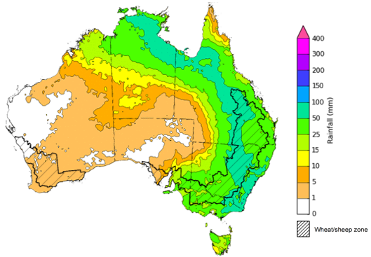
Issued 22/11/2023
Note: This rainfall forecast is produced from computer models. As the model outputs are not altered by weather forecasters, it is important to check local forecasts and warnings issued by the Bureau of Meteorology.
Water
Water storages, water markets and water allocations - current week
The Tableau dashboard may not meet accessibility requirements. For information about the contents of these dashboards contact ABARES.

Commodities
Information on weekly price changes in agricultural commodities is now available at the Weekly commodity price update.