
Publication date: 31 October 2024
The Land tenure of Australia 2010–11 to 2020–21 data package consists of seamless continental rasters showing Australia’s land tenure, and land tenure change, for three time periods 2010–11, 2015–16, and 2020–21. The datasets show where land is owned, leased, reserved or unallocated to a defined purpose in Australia.
The Land tenure of Australia 2010–11 to 2020–21 data package is a product of the Australian Collaborative Land Use and Management Program. This data package replaces the Land tenure of Australia 2010–11 to 2015–16 data package, with updates to these time periods.
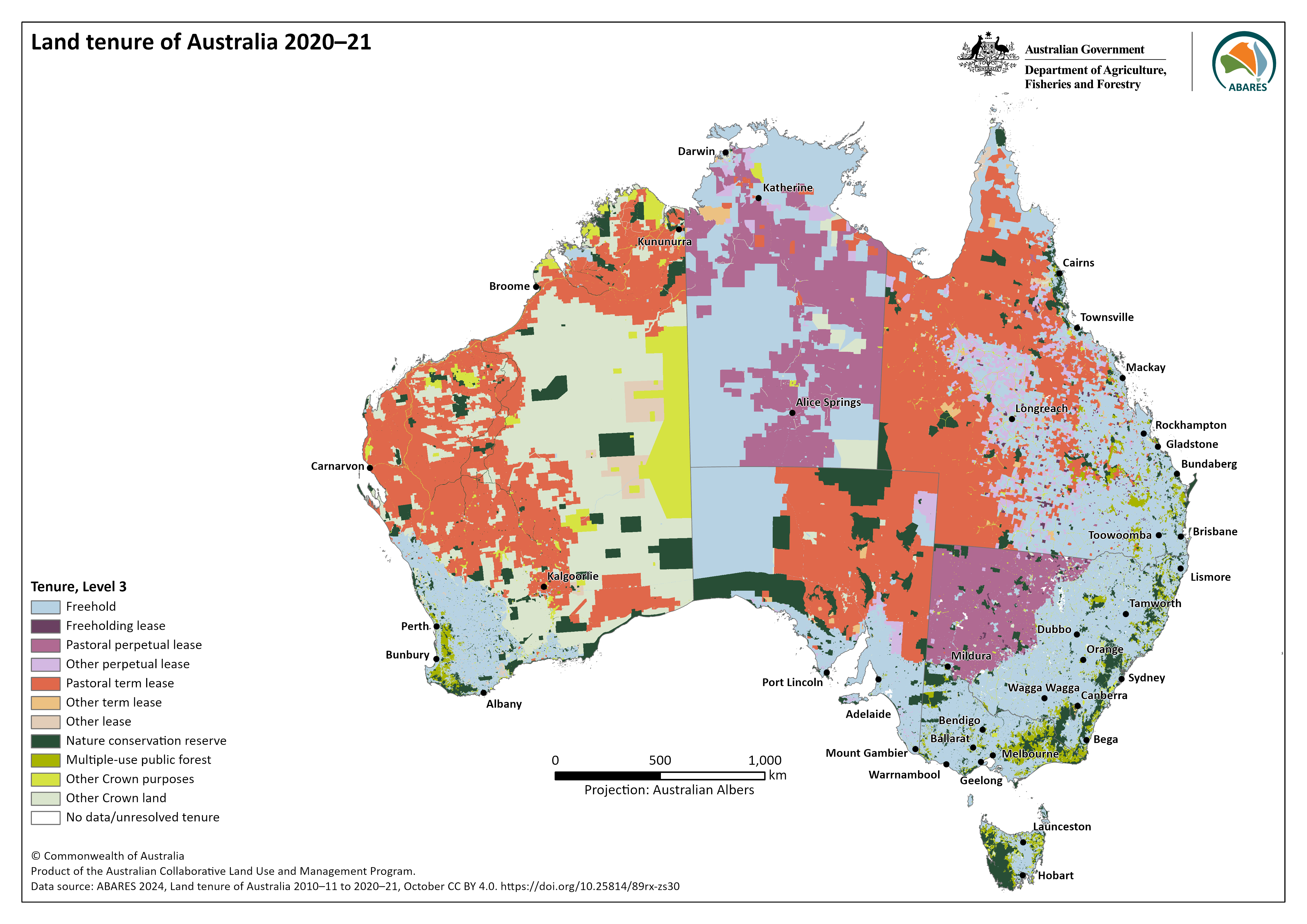
Map 1. Land tenure of Australia 2020–21 at Level 3
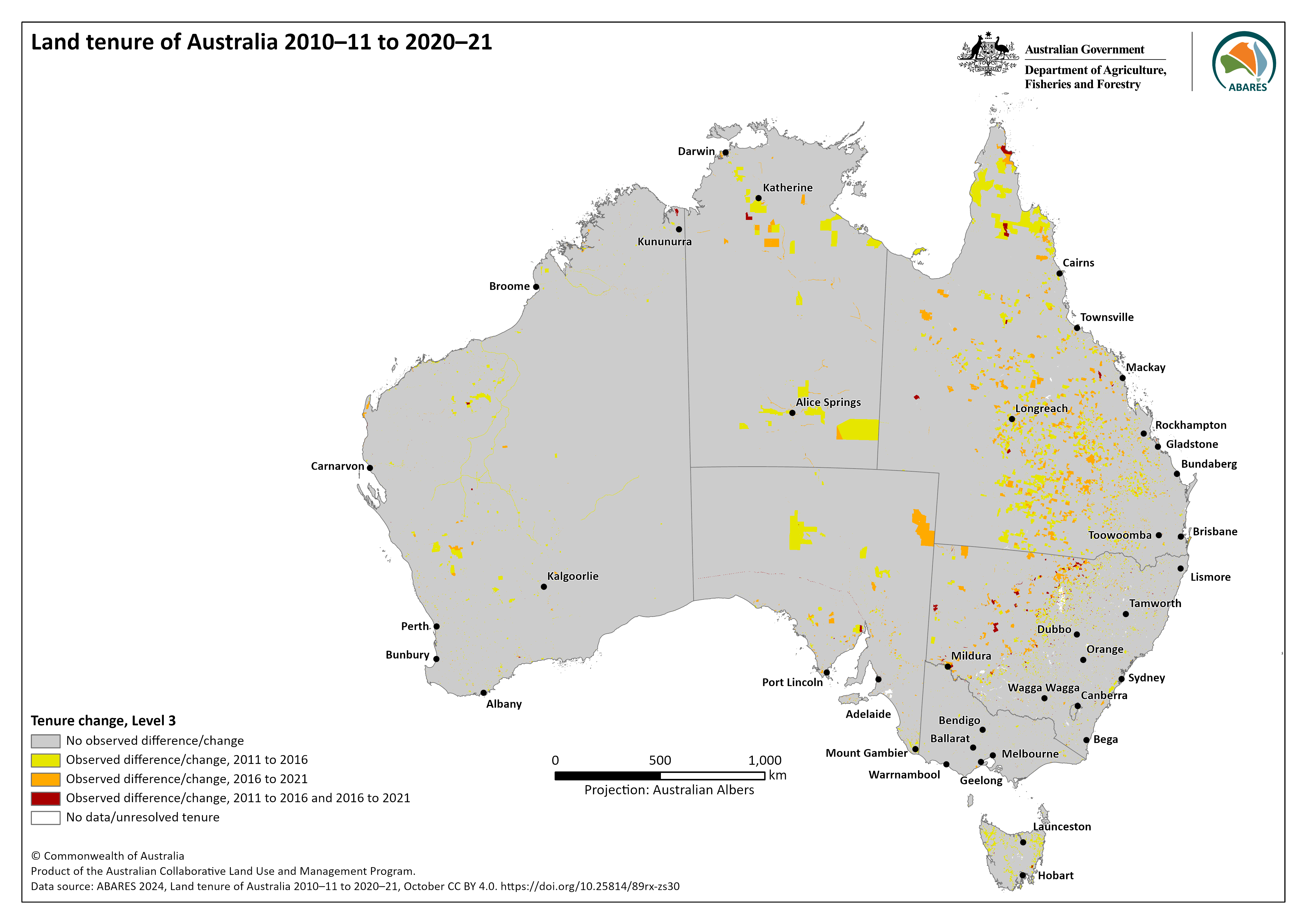
Map 2. Land tenure of Australia change at Level 3
The datasets were constructed by combining jurisdictional land title information from digital cadastral databases or their equivalents with Indigenous land grant instruments areas. The data package contains for each of the 3 time periods an independent raster and data caveat raster of known uncertainties in the product, plus 4 combined change rasters. The 5-yearly data is at a resolution of 250 by 250 metres.
- These datasets replace the Land tenure of Australia 2010–11 to 2015–16, 250 m released in September 2021. Data
updates and revisions are listed in the Lineage Statement. - These datasets have been made available for change analysis. With the nature of archived datasets, change may reflect
improved data quality. The data caveat rasters should be used to track possible data issues with the data. - The equal area projection (Australian Albers EPSG:3577) is provided for area calculations. The accuracy of the raw
area estimates is affected by the 250 by 250 m resolution of the tenure dataset and the input datasets used in their
construction. - This dataset does not provide a comprehensive assessment of Australia’s nature conservation reserve system. Only
the tenure type of Crown land Nature conservation reserve is captured. Nature conservation reserves can occur on
freehold land. - Freehold land owned by government and government entities, where declared, are included in Other Crown purposes,
as they are not consistently defined across state and territories as public or private land. - These datasets do not consider Indigenous peoples’ rights and interests in all lands, only for land granted under
Indigenous land grant instruments. For example, native title, which sits alongside land tenure, and Indigenous owned
freehold land outside Indigenous land grant instruments are not included. - No data/unresolved tenure captures areas where there is no tenure data or conflicting data sources. This category
includes water features that have unallocated tenure categories in state and territory registers
The entire contents of the Land tenure of Australia 2010–11 to 2020–21 data package including spatial data, data symbology, metadata and maps is available in a single zipped package – zip [96 MB]
The Land tenure of Australia 2010–11 to 2020–21 data package is also available on data.gov.au.
Data
Individual time periods with data caveats
- Land tenure of Australia 2020–21 – raster package (GeoTIFFs and supporting files) - zip [15 MB]
- Land tenure of Australia 2015–16 – raster package (GeoTIFFs and supporting files) - zip [15 MB]
- Land tenure of Australia 2010–11 – raster package (GeoTIFFs and supporting files) - zip [15 MB]
Tenure and associated change for the three time periods
Metadata
Land tenure of Australia 2010–11 to 2020–21 – descriptive metadata – MS Word [10.5 MB] and PDF [1.0 MB] – reflects the contents of the entire download package.
Maps
Maps of land tenure, tenure change and data caveats for the Land tenure of Australia 2010–11 to 2020–21 can be downloaded using the links below.
Tenure Level 1
![L1 2010-11 - [PNG 0.9MB]](https://www.agriculture.gov.au/sites/default/files/images/AUSTEN_v2_250m_L1_2010_11.png)
![L1 2015-16 - [PNG 0.9MB]](https://www.agriculture.gov.au/sites/default/files/images/AUSTEN_v2_250m_L1_2015_16.png)
![L1 2020-21 - [PNG 0.9MB]](https://www.agriculture.gov.au/sites/default/files/images/AUSTEN_v2_250m_L1_2020_21.png)
Tenure Level 2
![L2 2010-11 - [PNG 1MB]](https://www.agriculture.gov.au/sites/default/files/images/AUSTEN_v2_250m_L2_2010_11.png)
![L2 2015-16 - [PNG 1MB]](https://www.agriculture.gov.au/sites/default/files/images/AUSTEN_v2_250m_L2_2015_16.png)
![L2 2020-21 - [PNG 1MB]](https://www.agriculture.gov.au/sites/default/files/images/AUSTEN_v2_250m_L2_2020_21.png)
Tenure Level 3*
![L3 2010-11 - [PNG 1.2MB]](https://www.agriculture.gov.au/sites/default/files/images/AUSTEN_v2_250m_L3_2010_11.png)
![L3 2015-16 - [PNG 1.2MB]](https://www.agriculture.gov.au/sites/default/files/images/AUSTEN_v2_250m_L3_2015_16.png)
Tenure level 4
![L4 2010-11 - [PNG 1.3MB]](https://www.agriculture.gov.au/sites/default/files/images/AUSTEN_v2_250m_L4_2010_11.png)
![L4 2015-16 - [PNG 1.3MB]](https://www.agriculture.gov.au/sites/default/files/images/AUSTEN_v2_250m_L4_2015_16.png)
![L4 2020-21 - [PNG 1.3MB]](https://www.agriculture.gov.au/sites/default/files/images/AUSTEN_v2_250m_L4_2020_21.png)
Tenure Change Level 3* and 4
![Change L4 2010-11 to 2020-21 – [PNG 0.9MB]](https://www.agriculture.gov.au/sites/default/files/images/AUSTEN_v2_250m_CHANGE_L4_2010_11_to_2020_21.png)
Tenure Data Caveat
![Caveat 2010-11 - PNG [0.8MB]](https://www.agriculture.gov.au/sites/default/files/images/AUSTEN_v2_250m_DC_2010_11.png)
![Caveat 2015-16 - PNG [0.8MB]](https://www.agriculture.gov.au/sites/default/files/images/AUSTEN_v2_250m_DC_2015_16.png)
![Caveat 2020-21 - PNG [0.8MB]](https://www.agriculture.gov.au/sites/default/files/images/AUSTEN_v2_250m_DC_2020_21.png)
* Used for the National Land Accounts, Experimental Estimates.
Download a zipped folder containing all 17 maps as PNG and PDF - zip [43 MB]
ABARES 2024, Land tenure of Australia 2010–11 to 2020–21, Australian Bureau of Agricultural and Resource Economics and Sciences, Canberra, October, CC BY 4.0. DOI: 10.25814/89rx-zs30
Land tenure is classified according to a four-tiered hierarchical structure, ordered in increasing level of detail. Level 1 distinguishes between the basic land title types of Freehold and Crown land. Level 2 splits Crown land into Leasehold, dedicated or reserved for Crown purposes and Other Crown land. Level 3 further distinguishes Crown land, defining leasehold type or Crown purposes type based on term and purpose. Leasehold types are split into Freeholding lease, Pastoral perpetual lease, Other perpetual lease, Pastoral term lease, Other term lease, and Other lease. Crown purposes are split into Nature conservation reserve, Multiple-use public forest and Other Crown purposes. Level 4 distinguishes land with an Indigenous land grant, either Crown land held on behalf of, or freehold land owned by, traditional owner groups. Level 4 does not include native title which applies alongside tenure.
These data are a product of the Australian Collaborative Land Use and Management Program (ACLUMP). ACLUMP, a consortium of Australian, state and territory government partners, promotes the development of nationally consistent information on land use, land cover, and land management practices underpinned by common technical standards. See the metadata for more detailed acknowledgments for each dataset.
Analysis
A summary of Australia's land tenure as at 2020–21 is available here. The National Land Account, Experimental Estimates provide a physical account and change matrix for land tenure for Australia and for each state and territory.
Interactive views
Explore the Land tenure of Australia Web map. Tenure web services are also on the Digital Atlas of Australia.
- Land tenure of Australia 2020-21, Tenure Level 3
- Land tenure of Australia 2015-16, Tenure Level 3
- Land tenure of Australia 2010-11, Tenure Level 3
- Land tenure of Australia, Tenure change 2010–11 to 2020–21, Level 3
- Land tenure of Australia 2020-21, Tenure data caveat
- Land tenure of Australia 2015-16, Tenure data caveat
- Land tenure of Australia 2010-11, Tenure data caveat