Skip to main content Skip to main navigation Skip to search
ABARES - Land use and management

Top navigation abares

  • Department
  • Ministers
  • Media Centre
Main menu

Main navigation ACLUMP

  • Land home
    Land home
  • About ACLUMP
    About ACLUMP
  • Land use
    Land use
  • Publications
    Publications
  • Data download
    Data download
  • Latest news
    Latest news
Department of Agriculture

Breadcrumb

  1. DAFF Home
  2. ABARES
  3. Land use and management
  4. Land tenure

Secondary ACLUMP

  • ACLUMP
    • About ACLUMP
    • Latest news
    • Land data and maps
    • Land use
      • Land use mapping
      • Catchment scale land use of Australia and Commodities – Update December 2023
      • Catchment scale land use profiles
      • Mapping technical specifications
      • Land use apps
      • Data download
      • Publications
      • Australian Land Use and Management Classification
        • ALUM Classification Version 8 (October 2016)
      • Australian Agricultural Census 2020–21 visualisations
      • Land use of Australia 2010–11 to 2020–21
    • Land Management Practices
      • Collating LMP Information
      • Data and Maps
      • Drivers for LMP Information
      • Information System
      • Mapping ground cover management
      • Publications
    • Land tenure
      • Land tenure of Australia 2010–11 to 2020–21
    • Land Cover
      • Dynamic land cover
      • Ground cover monitoring for Australia
      • Ground cover indicator for drought resilience
      • Publications
    • Land Use Change Overview
      • Catchment scale examples
      • National scale examples
    • Publications
    • Definitions
    • Multi-Criteria Analysis Shell for Spatial Decision Support
      • MCAS-S tool
      • MCAS-S user guide
      • Australian national map layers
      • Quick Start Guide
        • 1. Introduction
        • 2. Set Up
        • 3. Input and Classification
        • 4. Composition and Comparison
        • 5. Building Criteria
        • 6. Reporting and Analysis
        • 7. Exporting
      • Preparing your own data
      • Updates
      • Disclaimer
      • MCAS-S-version-4

Land tenure

Tenure and property rights has been a major vehicle for economic growth, social development and natural resource management in Australia.

What is land tenure?

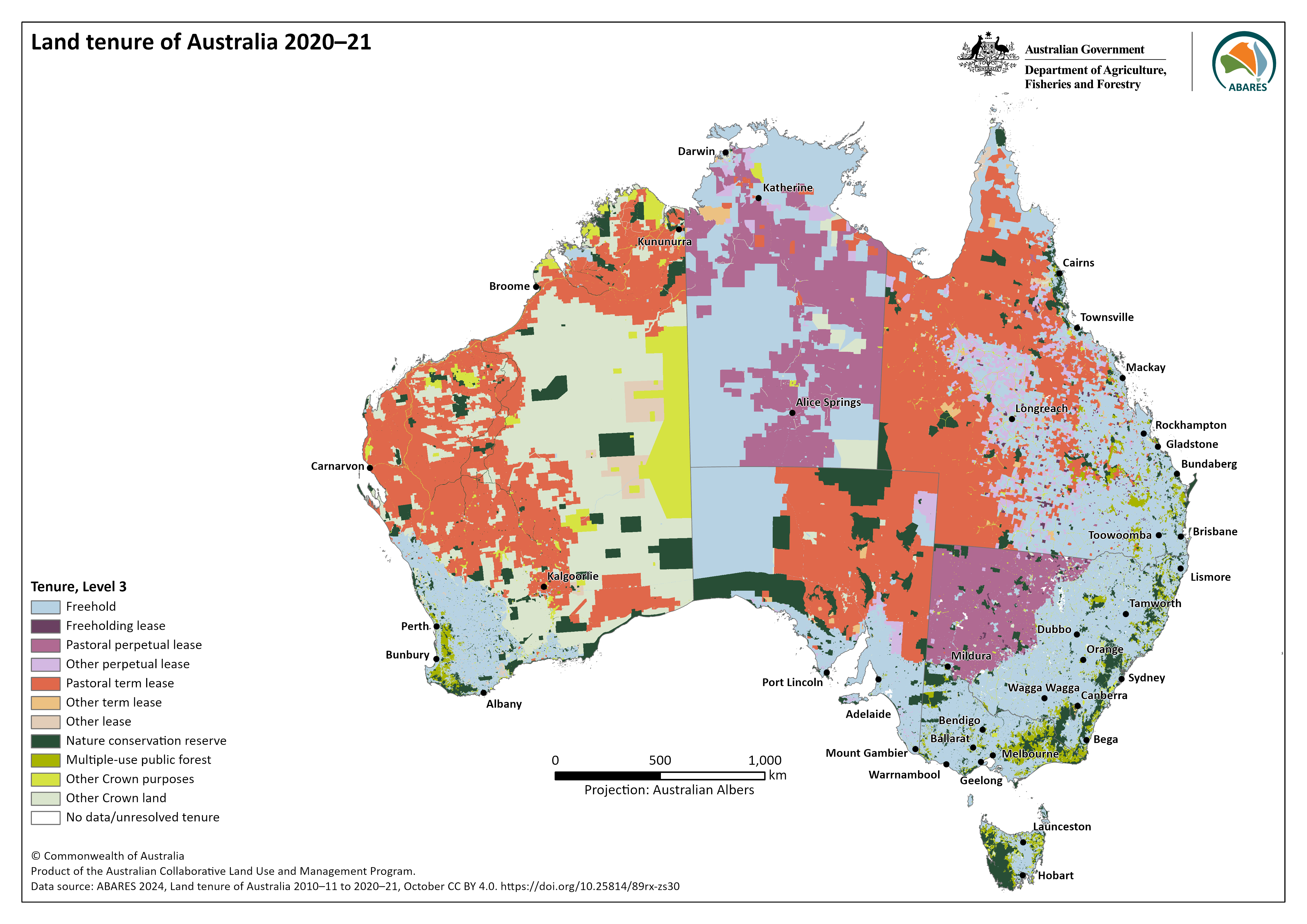
Land tenure is the legal regime in which land is owned, leased, reserved or unallocated to a defined purpose in Australia. Land tenure defines who can hold and use resources, for what length of time, and under what conditions.   

Australia's land tenure

Land tenure 2020-21Area (sq. km)Percent (%)
Freehold2,369,55630.8
Freeholding lease19,7040.3
Pastoral perpetual lease853,69311.1
Other perpetual lease196,3392.6
Pastoral term lease2,130,99127.7
Other term lease32,4280.4
Other lease78,7671.0
Nature conservation reserve596,5727.8
Multiple-use public forest111,5551.4
Other Crown purposes290,3113.8
Other Crown land1,00,730113.1
No data/unresolved tenure8,9230.1
Total7,696,138100

Numbers may not tally due to rounding. 
Source: ABARES (2024) Land tenure of Australia 2010-11 to 2020-21, Level 3

Map of Australia showing Land Tenure at Level 3 for 2020-21

Land tenure data was constructed by combining jurisdictional land title information from digital cadastre databases or their equivalents with Indigenous land grant instruments areas.

Data on Australia’s land tenure, and land tenure change, is available for 2010–11, 2015–16, and 2020–21. See the Land tenure of Australia 2010-11 to 2020-21 product page for more information, and to view or download the data. 

National classification system

Land tenure information has been classified according to a four-tiered hierarchical structure, ordered in increasing level of detail: 

  • Level 1 distinguishes between the basic land title types of Freehold and Crown land. 
  • Level 2 splits Crown land into Leasehold, dedicated or reserved for Crown purposes and Other Crown land. 
  • Level 3 further distinguishes Crown land, defining Leasehold type or Crown purposes type based on term and purpose. Leasehold types are split into Freeholding lease, Pastoral perpetual lease, Other perpetual lease, Pastoral term lease, Other term lease, and Other lease. Crown purposes are split into Nature conservation reserve, Multiple-use public forest and Other Crown purposes. 
  • Level 4 distinguishes land with an Indigenous land grant, either Crown land held on behalf of, or freehold land owned by, traditional owner groups. Level 4 does not include native title which applies alongside tenure.  

Download the Land Tenure of Australia Classification as an excel worksheet [100kb].

As tenure is legislated at a state and territory level not all classes are present as a tenure type in each Jurisdiction.

National Land Account

The Land tenure of Australia data series is an input to the National Land Account, Experimental Estimates. 


Thanks for your feedback.
Thanks! Your feedback has been submitted.

We aren't able to respond to your individual comments or questions.
To contact us directly phone us or submit an online inquiry

CAPTCHA
This question is for testing whether or not you are a human visitor and to prevent automated spam submissions.

Please verify that you are not a robot.

Skip
Page last updated: 31 October 2024

We acknowledge the continuous connection of First Nations Traditional Owners and Custodians to the lands, seas and waters of Australia. We recognise their care for and cultivation of Country. We pay respect to Elders past and present, and recognise their knowledge and contribution to the productivity, innovation and sustainability of Australia’s agriculture, fisheries and forestry industries.

Artwork: Protecting our Country, Growing our Future
© Amy Allerton, contemporary Aboriginal Artist of the Gumbaynggirr, Bundjalung and Gamilaroi nations.

Footer

  • Contact us
  • Accessibility
  • Disclaimer
  • Privacy
  • FOI

© Department of Agriculture, Fisheries and Forestry

Facebook X LinkedIn Instagram