
Key issues
- In the week ending 30 April 2025 low-pressure systems and troughs brought rainfall to the north and southeast.
- Rainfall totals were low in many cropping regions, with exceptions in New South Wales (5- 100 millimetres) and Victoria and parts of southern Queensland where 5-50 millimetres of rainfall was recorded.
- The recent week will likely delay germination of dry sown winter crops in areas where upper layer soil moisture is low. However, the rainfall recorded across central and northern New South Wales and parts of southern Queensland will likely support the germination and establishment of early sown winter crops.
- Over the coming eight days, rainfall is expected across limited parts of northern, eastern and the far southwest of Australia.
- Rainfall totals of between 5-10 millimetres are expected across parts of northern Queensland and the far southwest of Western Australia. Little to no rainfall is expected across remaining cropping regions.
- Most of Australia received average to above average rainfall over April 2025, with below average rainfall across parts of southeastern and west of Australia.
- As we transition into the remainder of autumn, the focus shifts from summer cropping and pasture growth across Northern Australia to winter cropping and peak pasture production in the south.
- The lack of rainfall in April and the below median rainfall outlook for May to July in southern New South Wales, western Victoria and South Australia present a downside risk to the timely planting of winter crops.
- This necessitates a careful monitoring and strategic planning to mitigate potential impacts on upcoming winter crops and managing ground cover and livestock numbers.
- Water storage levels in the Murray-Darling Basin (MDB) decreased between 24 April 2025 and 01 May 2025 by 17 gigalitres (GL). Current volume of water held in storage is 11,761 GL, equivalent to 53% of total storage capacity. This is 29 percent or 4,841 GL less than at the same time last year. Water storage data is sourced from the Bureau of Meteorology.
- Allocation prices in the Victorian Murray below the Barmah Choke increased from $262 on 17 April to $258 on 01 May April. Trade between Murrumbidgee and Murray IVTs are open.
Climate
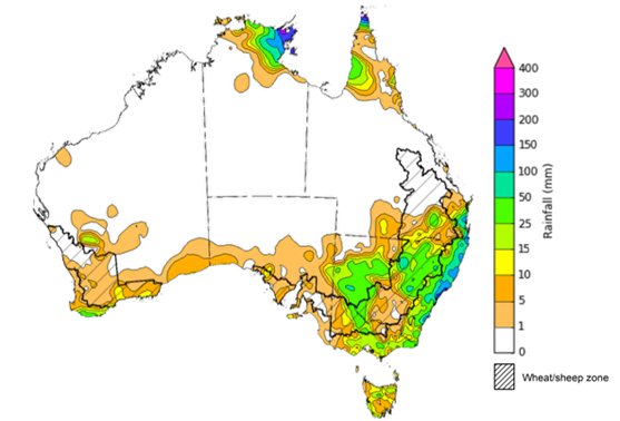
In the week ending 30 April 2025, low-pressure systems and troughs brought rainfall to some northern, south-eastern, and south-western regions of the country. High-pressure systems kept much of the remainder of Australia largely dry.
- The Northern Tropics, including Cape York Peninsula and the far north of the Northern Territory saw rainfall totals of between 5-200 millimetres, while northern Western Australia remained dry.
- Rainfall totals of between 5-150 millimetres were also recorded across much of New South Wales and parts of southern Queensland. In contrast, some areas of Victoria, Tasmania, and southwest Western Australia saw lower rainfall totals of between 5-50 millimetres.
- Little to no rainfall was observed across much of the remainder of the country
Cropping regions were largely dry, with the exception of parts of eastern Australia:
- Northern, central and southwest New South Wales cropping regions received between 5-100 millimetres. In Victoria and parts of southern Queensland, 5-50 millimetres of rainfall was recorded.
- Cropping regions in Western Australia, South Australia, and northern Queensland saw little to no rainfall over the period.
- Moving into the winter growing season, a lack of rainfall in the recent week will likely delay germination of dry sown winter crops in areas where upper layer soil moisture is low. However the rainfall recorded across central and northern New South Wales and parts of southern Queensland will likely support the germination and establishment of early sown winter crops.
Rainfall for the week ending 1 May 2025
Note: The rainfall analyses and associated maps utilise data contained in the Bureau of Meteorology climate database, the Australian Data Archive for Meteorology (ADAM). The analyses are initially produced automatically from real-time data with limited quality control. They are intended to provide a general overview of rainfall across Australia as quickly as possible after the observations are received. For further information go to http://www.bom.gov.au/climate/rainfall/
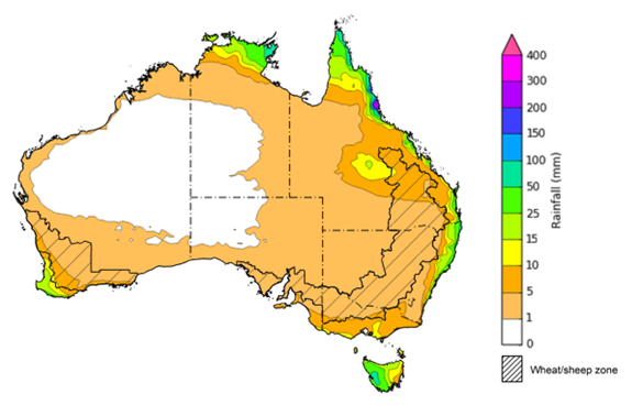
Over the 8 days to 8 May 2025, low-pressure systems are expected to bring limited rainfall to northern, eastern and the far southwest of Australia.
- Falls of between 5-50 millimetres are likely for parts of the northern tropics, including the north of the Northern Territory and northern Queensland, as well as parts of eastern Queensland and New South Wales, southern Victoria, and the far southwest of Western Australia.
- Isolated areas of northeast Queensland are expected to up to 300 millimetres of rainfall.
- Tasmania is expected to receive falls of between 10-100 millimetres, with higher rainfall totals in the west.
- High-pressure systems are expected to keep much of the remainder of Australia relatively dry.
Rainfall totals over the coming week are forecast to be low across most cropping regions.
- Rainfall totals of between 5-10 millimetres are expected across parts of northern Queensland and the far southwest of Western Australia. Little to no rainfall is expected across remaining cropping regions.
- If realised, the continued lack of autumn rainfall will continue to present a downside risk to the timely planting of winter crops particularly in those areas of southern New South Wales, western Victoria and South Australia with low stored soil moisture.
Total forecast rainfall for the period 1 May to 8 May 2025
Note: This rainfall forecast is produced from computer models. As the model outputs are not altered by weather forecasters, it is important to check local forecasts and warnings issued by the Bureau of Meteorology.
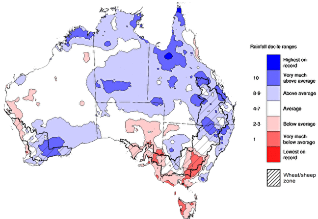
Rainfall during April 2025 was highly variable:
- Rainfall was very much below average to below average across parts of south-eastern Australia, including large areas of southern New South Wales, Victoria, South Australia, and Tasmania, as well as coastal regions of west Western Australia
- Above average to very much above average rainfall was recorded across much of the Northern Territory and Queensland, as well as much of southern Western Australia, and coastal and inland regions of New South Wales.
- The remainder of Australia saw generally average April rainfall.
In cropping regions, April rainfall was variable, with generally below average and average rainfall in the southeast and average to above rainfall in the north and west:
- Much of South Australia, Victoria, southern New South Wales and the west of Western Australia observed very much below average to average rainfall.
- In Queensland, northern New South Wales and the remainder of Western Australia average to very much above average rainfall was experienced over the period.
As we transition into the remainder of the autumn season, the focus shifts from summer crop and pasture growth across Northern Australia to preparing for the winter cropping season and peak pasture production in the south. This is especially crucial in regions that received below average rainfall in April. Given a below median rainfall outlook for May, and May to July period in parts of the southern regions, this necessitates a careful monitoring and strategic planning to mitigate potential impacts on upcoming winter crops and managing ground cover and livestock numbers.
Rainfall percentiles for April 2025
Water
Water storages, water markets and water allocations - current week
The Tableau dashboard may not meet accessibility requirements. For information about the contents of these dashboards contact ABARES.

Commodities
Information on weekly price changes in agricultural commodities is now available at the Weekly commodity price update.