Key issues
- During the 7 days to 31 March 2021, a blocking high pressure system resulted in little rainfall across much of southern Australia, while troughs in the north generated showers across northern Australia.
- While little or no rainfall was recorded across cropping regions this week, most eastern cropping regions are entering the winter planting period with increased soil moisture levels following the heavy falls in the previous week. The recent dry conditions have allowed the harvesting of late sown summer crops, preparatory field work and the planting of winter forage crops to continue.
- The heavy rainfall recorded across northern New South Wales and southern Queensland during late March led to harvest delays due to waterlogging and some grain quality downgrades and sprouting in summer crops nearing harvest. However, these falls have substantially improved soil moisture levels and improved yield prospects for some late-sown crops.
- ABARES analysis of daily rainfall totals indicated that an early autumn break had been achieved across much of southern Australia cropping regions due to the heavy rainfall in mid- to late-March. This early autumn break suggests a positive outlook for the winter growing season as it will likely increase the length of the growing season, potentially improving production and yield.
- Over the next 8 days, troughs and cold fronts are expected to generate showers and storms over parts of northern and eastern Australia.
- In Australia’s cropping regions, little to no rainfall is expected across much of southern New South Wales, Victoria, South Australia and Western Australia over the next 8 days. Rainfall totals of between 10 and 50 millimetres are expected across cropping regions in north-eastern New South Wales and Queensland. Following an early autumn break across most winter cropping regions in western and eastern Australia during mid- to late-March, these low rainfall totals will likely allow farmers to continue sowing winter forage crops.
- Water storage levels in the Murray-Darling Basin (MDB) increased by 575 gigalitres (GL) between 24 March 2021 and 31 March 2021. The current volume of water held in storage is 14,142 GL, which represents 56% of total capacity.
- Allocation prices in the Victorian Murray below the Barmah Choke increased from $69 per ML on 25 March 2021 to $75 per ML on 1 April 2021. Prices are lower in the Murrumbidgee due to the binding of the Murrumbidgee export limit.
Climate
[expand all]
Rainfall this week
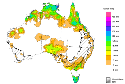
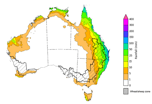
During the week ending 31 March 2021, a blocking high pressure system resulted in little rainfall across much of southern Australia, while troughs in the north generated showers across northern Australia.
Rainfall totals of between 10 and 50 millimetres were recorded across parts of the north of Queensland, the Northern Territory and Western Australia, as well as parts of central South Australia, southern Victoria and isolated parts of southern New South Wales. Rainfall in excess of 50 millimetres was recorded across northern parts of Queensland, Western Australia, the Northern Territory and much of Tasmania. Rainfall in excess of 100 millimetres was recorded in isolated parts of north-eastern Queensland, the north of the Northern Territory and eastern Tasmania.
In Australia’s cropping regions, rainfall between 5 and 10 millimetres was recorded across isolated parts of south-eastern New South Wales, north-eastern Queensland and eastern Victoria. Little to no rainfall was recorded across remaining cropping regions.
While little or no rainfall was recorded across cropping regions this week, most eastern cropping regions are entering the winter planting period with increased soil moisture levels following the heavy falls in the previous week. The recent dry conditions have allowed the harvesting of late sown summer crops, preparatory field work and the planting of winter forage crops to continue.
Rainfall for the week ending 31 March 2021
©Commonwealth of Australia 2021, Australian Bureau of Meteorology - Issued: 31/03/2021
Note: The rainfall analyses and associated maps utilise data contained in the Bureau of Meteorology climate database, the Australian Data Archive for Meteorology (ADAM). The analyses are initially produced automatically from real-time data with limited quality control. They are intended to provide a general overview of rainfall across Australia as quickly as possible after the observations are received. For further information go to http://www.bom.gov.au/climate/rainfall/
Monthly rainfall
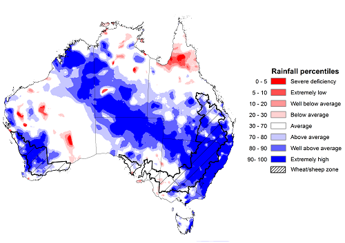
Rainfall during March 2021 was above average for much of Australia. Rainfall was well above average to extremely high across much of New South Wales, southern Queensland, northern South Australia, the south of the Northern Territory and parts of Western Australia. Rainfall was well below average to below average across isolated parts of northern Queensland, central and southern Western Australia and the north of the Northern Territory.
According to oceanic and atmospheric indicators, the La Niña event continued to weaken but still influenced the Australian climate throughout March. In mid- to late-March, troughs, low-pressure systems and moist tropical air generated heavy rainfall and thunderstorms in parts of eastern, central and northern Australia.
March rainfall was significantly above average for most of the cropping regions in New South Wales, Queensland and Western Australia. Rainfall was average to above average for most of the cropping regions in South Australia and Victoria.
The heavy rainfall recorded across northern New South Wales and southern Queensland during late March led to harvest delays due to waterlogging and some grain quality downgrades and sprouting in summer crops nearing harvest. However, these falls have substantially improved soil moisture levels and improved yield prospects for some late-sown crops.
The increased soil moisture is expected to provide ideal conditions for the sowing of winter crops, pasture growth and continued livestock restocking. ABARES analysis of daily rainfall totals indicated that an early autumn break had been achieved across much of southern Australia cropping regions due to the heavy rainfall in mid- to late-March. ABARES adapted the Pook et al. (2009) autumn break definition of falls of 30 millimetres or more recorded within any 7-day period from 1 March to identify where the autumn break threshold had been achieved. This early autumn break suggests a positive outlook for the winter growing season as it will likely increase the length of the growing season, potentially improving production and yield.
Rainfall percentiles for March 2021
Source: Bureau of Meteorology
Note: Rainfall for March 2021 is compared with rainfall recorded for that period during the historical record (1900 to present). For further information, go to http://www.bom.gov.au/water/
Monthly soil moisture
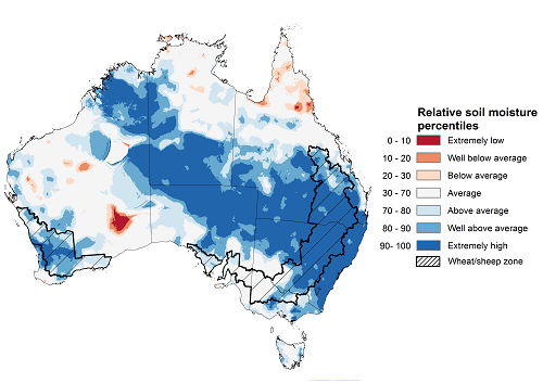
Upper layer soil moisture in March 2021 was above average to extremely high for this time of year across much of the eastern, western and central Australia, reflecting rainfall patterns during the month. Modelled soil moisture was well below average to below average across isolated areas of Western Australia and northern Queensland. Upper layer soil moisture is important at the beginning of the winter cropping season since plant germination and establishment utilise this moisture.
Relative upper layer soil moisture was well above average to extremely high for this time of year across most cropping regions in New South Wales, Queensland and Western Australia. Soil moisture was average to above average across most cropping regions in Victoria and South Australia.
Modelled upper layer soil moisture for March 2021
Source: Bureau of Meteorology (Australian Water Resources Assessment Landscape model)
Note: This map shows the levels of modelled upper layer soil moisture (0 to 10 centimetres) during March 2021. This map shows how modelled soil conditions during March 2021 compare with March conditions modelled over the reference period (1911 to 2016). Dark blue areas on the maps were much wetter in March 2021 than during the reference period. The dark red areas were much drier than during the reference period. The bulk of plant roots occur in the top 20 centimetres of the soil profile. Soil moisture in the upper layer of the soil profile is therefore useful indicator of the availability of water, particularly for germinating seed.
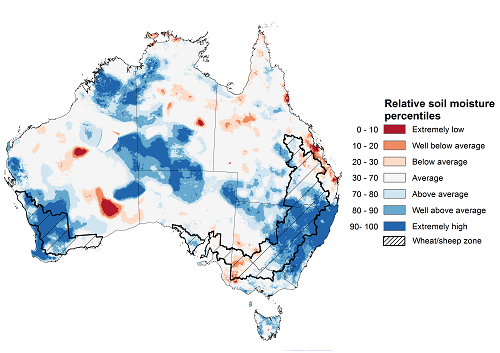
Lower layer soil moisture for March 2021 was above average to extremely high for this time of year across large areas of north-western, south -western, central and south-eastern Australia. Lower layer soil moisture was well below average to below average across parts of eastern and western Queensland, western Victoria, central Western Australia and isolated parts of south-western New South Wales and the north and centre of the Northern Territory.
In cropping regions, lower layer soil moisture was above average to extremely high for much of New South Wales, southern Queensland and Western Australian cropping regions. Lower layer soil moisture was generally average in South Australia and below average to average in cropping regions across Victoria and parts of eastern and central Queensland. Average or better soil moisture across southern cropping regions ahead of winter crop sowing is likely to increase planting confidence and crop production potential.
Modelled lower layer soil moisture for March 2021
Source: Bureau of Meteorology (Australian Water Resources Assessment Landscape model)
Note: This map shows the levels of modelled lower layer soil moisture (10 to 100 centimetres) during March 2021. This map shows how modelled soil conditions during March 2021 compare with March conditions modelled over the reference period (1911 to 2016). Dark blue areas on the maps were much wetter in March 2021 than during the reference period. The dark red areas were much drier than during the reference period. The bulk of plant roots occur in the top 20 centimetres of the soil profile. The lower layer soil moisture is a larger, deeper store that is slower to respond to rainfall and tends to reflect accumulated rainfall events over longer time periods.
Rainfall forecast for the next eight days
Troughs, onshore winds, troughs and cold fronts are expected to generate showers and storms over parts of northern and eastern Australia during the next 8 days.
Rainfall totals of between 10 and 50 millimetres are forecast for parts of eastern New South Wales, northern and eastern Queensland and parts of western and northern Western Australia, the north of the Northern Territory and Tasmania. Rainfall totals in excess of 50 millimetres are forecast for parts of northern Australia and the far east of New South Wales and Queensland.
In Australia’s cropping regions, little to no rainfall is expected across much of southern New South Wales, Victoria, South Australia and Western Australia. Rainfall totals of between 10 and 50 millimetres are expected across cropping regions in north-eastern New South Wales and Queensland. Following an early autumn break across most winter cropping regions in western and eastern Australia during mid- to late-March, these low rainfall totals will likely allow farmers to continue sowing winter forage crops.
Total forecast rainfall (mm) for the period 1 April to 8 April 2021
©Commonwealth of Australia 2021, Australian Bureau of Meteorology - Issued: 1/04/2021
Note: This rainfall forecast is produced from computer models. As the model outputs are not altered by weather forecasters, it is important to check local forecasts and warnings issued by the Bureau of Meteorology.
Water
Water storages, water markets and water allocations - current week
The Tableau dashboard may not meet accessibility requirements. For information about the contents of these dashboards contact ABARES.
Commodities
Information on weekly price changes in agricultural commodities is now available at the Weekly commodity price update.

