Key issues
- During the 7 days to 3 March 2021, troughs and low-pressure systems generated showers across much of eastern, western and northern of Australia. The recent rainfall in northern cropping regions may delay summer crop harvest activities, but is likely to boost soil moisture levels ahead of the sowing of winter crops during autumn.
- In summer cropping regions, February rainfall was average to extremely high across New South Wales and generally average across western parts of the Queensland cropping regions. The substantial rainfall in New South Wales and western Queensland is likely to benefit the production prospects and yield potential of dryland crops. Rainfall was severely deficient to below average across parts of eastern Queensland. Low rainfall across parts of south-eastern Queensland has adversely affected pasture production and may have resulted in poor crop development in later sown summer crops.
- Nationally, summer 2020–2021 rainfall was above average, with La Niña and a positive Southern Annular Mode influencing Australia’s climate for much of the season.
- Summer 2020–2021 rainfall was above average to extremely high across most summer cropping regions in New South Wales and generally average across summer cropping regions in far northern, western and southern Queensland. In contrast, extremely low to below average rainfall was recorded in summer cropping regions across parts central and eastern Queensland. Average or better rainfall during much of the season benefitted summer crop yield and pasture production across much of eastern and northern Australia.
- Over the next 8 days, troughs, onshore flow and severe Tropical Cyclone Niran are expected to generate showers and storms over parts of northern, south-western and eastern Australia.
- In Australia’s summer cropping regions, rainfall of between 10 and 50 millimetres is expected for parts of northern and eastern New South Wales, central and southern Queensland, and central and southern Western Australia over the next 8 days.
- Water storage levels in the Murray-Darling Basin (MDB) increased by 697 gigalitres (GL) between 24 February 2021 and 3 March 2021. The current volume of water held in storage is 14,071 GL, which represents 56% of total capacity.
- Allocation prices in the Victorian Murray below the Barmah Choke increased from $100 per ML on 25 February 2021 to $105 per ML on 4 March 2021. Prices are lower in Murrumbidgee and regions above the Barmah Choke due to binding of the Murrumbidgee export limit and Barmah Choke trade constraint.
Climate
[expand all]
Rainfall this week
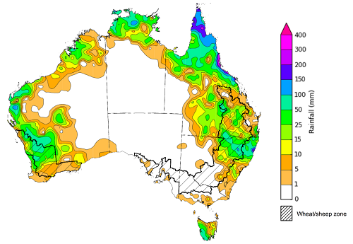
During the week ending 3 March 2021, troughs and low-pressure systems generated showers across much of eastern, western and northern of Australia. The formation of severe Tropical Cyclone Niran off north-eastern Australia also brought heavy falls to parts of northern Queensland.
Rainfall totals of between 15 and 50 millimetres were recorded across much of Queensland and Tasmania, and parts of north-eastern New South Wales, western and northern Western Australia and the north of the Northern Territory. Rainfall in excess of 50 millimetres was recorded across parts of northern and eastern Queensland, north-eastern New South Wales, the west of Western Australia, the far north of the Northern Territory and western Tasmania.
In Australia’s cropping regions, rainfall totals of between 25 and 100 millimetres were recorded across parts of northern New South Wales, central and southern Queensland and central and northern Western Australia. Little to no rainfall was recorded across remaining cropping regions.
The recent rainfall in northern cropping regions may delay summer crop harvest activities, but is likely to boost soil moisture levels ahead of the sowing of winter crops during autumn.
Rainfall for the week ending 3 March 2021
©Commonwealth of Australia 2021, Australian Bureau of Meteorology - Issued: 03/03/2021
Note: The rainfall analyses and associated maps utilise data contained in the Bureau of Meteorology climate database, the Australian Data Archive for Meteorology (ADAM). The analyses are initially produced automatically from real-time data with limited quality control. They are intended to provide a general overview of rainfall across Australia as quickly as possible after the observations are received. For further information go to http://www.bom.gov.au/climate/rainfall/
Monthly temperatures
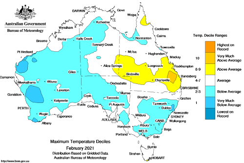
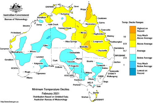
February 2021 was cooler than average nationally with a national mean temperature of 0.22°C below average and a mean maximum temperature of 0.44°C below average.
Maximum temperatures for February were above average to very much above average across parts of southern Queensland. Minimum temperatures were above average to very much above average across parts of north-eastern Australia. Maximum temperatures were very much below average to below average across large parts of the western half of Australia and southern Australia. Similarly, minimum temperatures were very much below average to below average across parts of western and southern Australia. Across cropping regions in Queensland, above average temperatures coupled with low rainfall and low soil moisture levels are likely to have adversely impacted production prospects of dryland summer crops.
Maximum temperature deciles for February 2021
©Commonwealth of Australia 2021, Australian Bureau of Meteorology - Issued: 01/03/2021
Minimum temperature deciles for February 2021
©Commonwealth of Australia 2021, Australian Bureau of Meteorology - Issued: 01/03/2021
Note: Maximum and minimum temperatures for February 2021 compared with temperature recorded for that period during the historical record (1900 to present). For further information go to: http://www.bom.gov.au/water.
Monthly rainfall
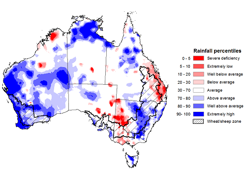
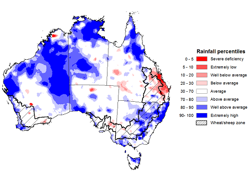
Rainfall during February 2021 was above average nationally. Rainfall was above average to extremely high across much of Western Australia, and parts of central and eastern New South Wales, northern Queensland, north-eastern Victoria, south-eastern and northern South Australia, the north and south of the Northern Territory and Tasmania. Rainfall was severely deficient to below average across parts of western New South Wales, eastern Queensland, western Victoria, eastern South Australia and northern Western Australia.
Oceanic and atmospheric indicators suggest La Niña was passed its peak by February. The La Niña continued to influence Australian climate during February despite weakening through the month. The Southern Annular Mode (SAM) was positive for the first half of February and generally neutral for the remainder of the month. During summer, La Niña and a positive SAM typically increase the chance of rainfall in northern and eastern Australia. When SAM is neutral it has low influence on rainfall. A strong Madden–Julian Oscillation (MJO) for parts of February had a small influence on the development of tropical lows, cyclones and above average rainfall across parts of northern Australia.
In summer cropping regions, February rainfall was average to extremely high across New South Wales and generally average across western Queensland. Rainfall was severely deficient to below average across parts of eastern Queensland summer cropping regions. The substantial rainfall in New South Wales and western Queensland likely benefitted the production prospects and yield potential of dryland crops. Low rainfall across summer cropping regions in parts of eastern and central Queensland may have had adverse impacts on pasture and crop development during the month. Average or better February rainfall totals and stored soil moisture across northern Australia have been sufficient to maintain average to above average pasture production and support livestock restocking confidence.
Rainfall percentiles for February 2021
Source: Bureau of Meteorology
Note: Rainfall for February 2021 is compared with rainfall recorded for that period during the historical record (1900 to present). For further information, go to http://www.bom.gov.au/water/
Seasonal rainfall
Summer 2020–2021 rainfall was above average nationally, with La Niña and a positive Southern Annular Mode influencing Australia’s climate for much of the season. Summer 2020–2021 rainfall was above average to extremely high across most summer cropping regions in New South Wales and generally average across summer cropping regions in far northern, western and southern Queensland. Extremely low to below average rainfall was recorded in summer cropping regions across parts central and eastern Queensland.
The season began with generally average rainfall across summer cropping regions in Queensland and above average or better rainfall across New South Wales summer cropping regions. Following low November rainfall totals, this rainfall was favourable for the late planting of summer crops and supported crop growth. Significant December rainfall across most of northern Australia provided conditions for above average pasture production and increased incentives for livestock restocking.
During January La Niña continued at moderate levels and January rainfall was generally average across summer cropping regions. Despite below average January rainfall across parts of northern Australia, rainfall totals and stored soil moisture were sufficient to maintain average to above average pasture production and support livestock restocking confidence.
Despite La Niña weakening in February, it continued to influence Australia’s climate. This contributed to above average to extremely high rainfall across most of New South Wales summer cropping regions and parts of northern Australia. In contrast, rainfall was severely deficient to below average across parts of eastern and central Queensland summer cropping regions. The agricultural impact of these conditions during February have been discussed in the Monthly rainfall section.
Rainfall percentiles for summer 2020–2021 (1 December 2020 to 28 February 2021)
Source: Bureau of Meteorology
Note: Rainfall for December 2020 to February 2021 is compared with rainfall recorded for that period during the historical record (1900 to present). For further information, go to http://www.bom.gov.au/water/
Monthly soil moisture
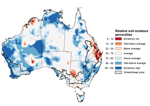
Upper layer soil moisture in February 2021 was above average to extremely high for this time of year across much of the western half of Australia and parts of eastern and northern Australia, largely reflecting rainfall patterns during the month. Modelled soil moisture was extremely low to below average across isolated parts of western and eastern Australia. Upper layer soil moisture is less important for summer crops during the later plant and grain development growth stages as plants are able access stored moisture in lower soil layers.
Relative upper layer soil moisture was above average to extremely high for this time of year across most summer cropping regions in New South Wales and south-eastern Queensland. Soil moisture was extremely low to below average across summer cropping regions in eastern Queensland and generally average across western Queensland.
Modelled upper layer soil moisture for February 2021
Source: Bureau of Meteorology (Australian Water Resources Assessment Landscape model)
Note: This map shows the levels of modelled upper layer soil moisture (0 to 10 centimetres) during February 2021. This map shows how modelled soil conditions during February 2021 compare with February conditions modelled over the reference period (1911 to 2016). Dark blue areas on the maps were much wetter in February 2021 than during the reference period. The dark red areas were much drier than during the reference period. The bulk of plant roots occur in the top 20 centimetres of the soil profile. Soil moisture in the upper layer of the soil profile is therefore useful indicator of the availability of water, particularly for germinating seed.
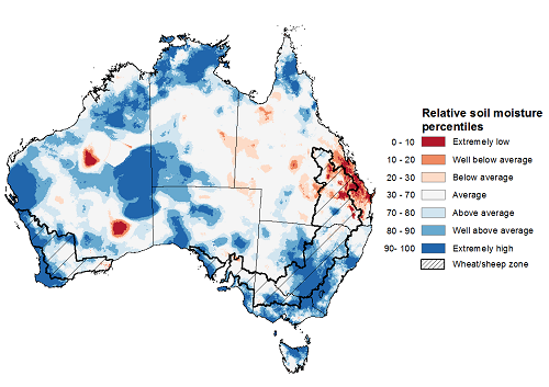
Lower layer soil moisture for February 2021 was above average to extremely high for this time of year across much of the western half of Australia, and large parts of southern and northern Australia. Lower layer soil moisture was extremely low to below average across parts of central and southern Queensland and isolated parts of Western Australia.
In cropping regions, lower layer soil moisture was average to extremely high for much of New South Wales, Victoria, South Australia, Western Australia and isolated parts of southern and far northern Queensland. Lower layer soil moisture was extremely low to below average in cropping regions across parts of eastern and central Queensland. Average or better soil moisture across southern cropping regions ahead of winter crop sowing during autumn is likely to increase planting confidence and crop production potential. Low soil moisture in cropping regions across parts of Queensland is likely to adversely affect production and yield for later sown summer crops as they enter the critical flowering and grain development stages of growth.
Modelled lower layer soil moisture for February 2021
Source: Bureau of Meteorology (Australian Water Resources Assessment Landscape model)
Note: This map shows the levels of modelled lower layer soil moisture (10 to 100 centimetres) during February 2021. This map shows how modelled soil conditions during February 2021 compare with February conditions modelled over the reference period (1911 to 2016). Dark blue areas on the maps were much wetter in February 2021 than during the reference period. The dark red areas were much drier than during the reference period. The bulk of plant roots occur in the top 20 centimetres of the soil profile. The lower layer soil moisture is a larger, deeper store that is slower to respond to rainfall and tends to reflect accumulated rainfall events over longer time periods.
Rainfall forecast for the next eight days
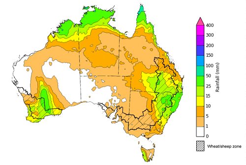
Troughs, onshore flow and severe Tropical Cyclone Niran are expected to generate showers and storms over parts of northern, south-western and eastern Australia during the next 8 days.
Rainfall totals of between 10 and 50 millimetres are forecast for parts of eastern New South Wales, southern and northern Queensland, south-western and northern Western Australia, the north of the Northern Territory and western Tasmania.
In Australia’s cropping regions, rainfall of between 10 and 50 millimetres are expected for parts of northern and eastern New South Wales, central and southern Queensland, and central and southern Western Australia.
Total forecast rainfall (mm) for the period 4 March to 11 March 2021
©Commonwealth of Australia 2021, Australian Bureau of Meteorology - Issued: 04/03/2021
Note: This rainfall forecast is produced from computer models. As the model outputs are not altered by weather forecasters, it is important to check local forecasts and warnings issued by the Bureau of Meteorology.
Water
Water storages, water markets and water allocations - current week
The Tableau dashboard may not meet accessibility requirements. For information about the contents of these dashboards contact ABARES.
Commodities
Information on weekly price changes in agricultural commodities is now available at the Weekly commodity price update.

