
- During the week ending 3 November 2021, low pressure troughs brought storms and significant rainfall to parts of northern and eastern Australia. In the south, low-pressure systems and associated cold fronts brought substantial rainfall to Tasmania and southern parts of the mainland over the 8 days to 3 November 2021.
- The wet conditions across southern Queensland and northern New South Wales may have interrupted harvesting activities. Likewise, the planting of summer crops in Queensland and northern New South Wales may have been briefly interrupted, but is likely to continue over the coming weeks, encouraged by above average soil moisture levels in parts. Despite the dry conditions in Western Australian cropping regions this week, above average rainfall earlier in October has provided a boost to soil moisture levels. For cropping regions in the south-east, soil moisture levels remain generally average despite a lack of rainfall over the past week. However, the dry conditions will have provided ideal conditions for fodder conservation and pre-harvest field work such as windrowing of canola.
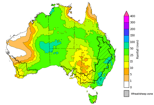
- Rainfall during October 2021 was below average in isolated patches across New South Wales, Queensland, South Australia, Western Australia and the Northern Territory. Above average rainfall was recorded across part of eastern New South Wales, southeast and western Queensland, southern Victoria, isolated parts of South Australia, the west of Western Australia, the north and east of the Northern Territory, as well as Tasmania. Rainfall was close to average in remaining parts of Australia.
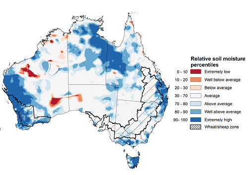
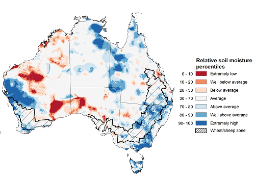
- Upper layer soil moisture in October 2021 was generally average for this time of year across much of Australia, following average to above average rainfall throughout the month. Lower layer soil moisture for October 2021 was above average for this time of year across large areas of northern Australia, as well as parts of western, central and south-eastern Australia.
- Over the 8-days to 11 November 2021 a series of troughs and low-pressure systems are expected to draw down moist, tropical air across much of northern, central and eastern Australia, resulting in storms and substantial rainfall. Only some isolated parts of Australia, including the far west, are expected to receive little to no rainfall over the next 8 days.
- Water storage in the Murray–Darling Basin (MDB) decreased by 31 gigalitres (GL) between 27 October 2021 and 3 November 2021. The current volume of water held in storage is 22,063 GL, which represents 87% of total capacity. This is 40% or 6,290 GL more than at the same time last year.
- Allocation prices in the Victorian Murray below the Barmah Choke increased from $114 per ML on 22 October 2021 to $123 per ML on29 October 2021. Prices are lower in the Goulburn-Broken, Murrumbidgee, and regions above the Barmah choke due to the binding of the Goulburn intervalley trade limit, Murrumbidgee export limit, and Barmah choke trade constraint.
During the week ending 3 November 2021, low pressure troughs brought storms and significant rainfall to parts of northern and eastern Australia. In the south, low-pressure systems and associated cold fronts brought substantial rainfall to Tasmania and southern parts of the mainland over the 8 days to 3 November 2021.
Rainfall totals of between 10 and 50 millimetres were recorded in parts of north-eastern and western New South Wales, a broad band of Queensland stretching from south-east to north-west, southern Victoria, the south and west of South Australia, the north of Western Australia, much of the Northern Territory and north-eastern Tasmania. Rainfall totals in excess of 50 millimetres were recorded across scattered areas of Queensland, the north of Western Australia and parts of the Northern Territory, as well as much of Tasmania
In cropping regions, rainfall totals of between 10 and 50 millimetres were recorded in northern New South Wales, southern Queensland, as well as isolated parts of Victoria, South Australia and Western Australia. Little to no rainfall was recorded across remaining cropping regions.
The wet conditions across southern Queensland and northern New South Wales may have interrupted harvesting activities. Likewise, the planting of summer crops in Queensland and northern New South Wales may have been briefly interrupted, but is likely to continue over the coming weeks, encouraged by above average soil moisture levels in parts. Despite the dry conditions in Western Australian cropping regions this week, above average rainfall earlier in October has provided a boost to soil moisture levels. For cropping regions in the south-east, soil moisture levels remain generally average despite a lack of rainfall over the past week. However, the dry conditions will have provided ideal conditions for fodder conservation and pre-harvest field work such as windrowing of canola.
Rainfall for the week ending 3 November 2021
Note: The rainfall analyses and associated maps utilise data contained in the Bureau of Meteorology climate database, the Australian Data Archive for Meteorology (ADAM). The analyses are initially produced automatically from real-time data with limited quality control. They are intended to provide a general overview of rainfall across Australia as quickly as possible after the observations are received.
For further information go to http://www.bom.gov.au/climate/rainfall/
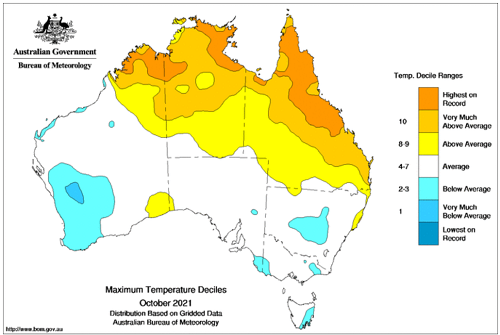
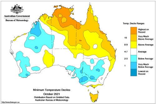
October 2021 monthly mean temperatures were around 0.93°C warmer than the 1961-1990 average for Australia as a whole. The mean maximum temperature was 1.09°C above average, and the mean minimum temperature was 0.77°C above average.
Maximum temperatures for October were very much above average for parts of northern Australia, with the warmest temperatures on record for some regions, but below average in the southwest and isolated parts of the southeast of Australia. Remaining parts of the country were mostly average. Minimum temperatures were above average to very much above average across much of Queensland, the Northern Territory and Tasmania and below average to very much below average across much of New South Wales, western Victoria, the south-east of South Australia, as well as parts of the south-west and north of Western Australia.
The above average temperatures across Queensland will have assisted with the maturation of winter crops as well as the germination of summer crops. Below average temperatures across Western Australia have allowed crops to fill grain. This is particularly the case in the central and northern regions where soil moisture reserves declined to very low levels during September and is likely to have halted a rapid loss in grain yield potential in these regions.
Maximum temperature deciles for October 2021
Minimum temperature deciles for October 2021
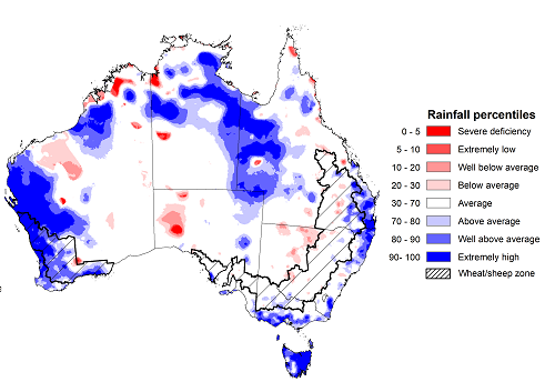
Rainfall during October 2021 was below average in isolated patches across New South Wales, Queensland, South Australia, Western Australia and the Northern Territory. Above average rainfall was recorded across part of eastern New South Wales, southeast and western Queensland, southern Victoria, isolated parts of South Australia, the west of Western Australia, the north and east of the Northern Territory, as well as Tasmania. Rainfall was close to average in remaining parts of Australia.
The Indian Ocean Dipole (IOD) index returned below the negative threshold (-0.4°C) for much of October. Oceanic and sea surface indicators also suggest the likely development of a La Niña event. However, both climate patterns are usually associated with above average rainfall for south-eastern Australia, which was not widely observed throughout October.
In cropping regions, October rainfall was close to the average across much of New South Wales, Queensland, Victoria and South Australia. Below average rainfall was recorded in cropping regions in isolated parts of western New South Wales and southern Queensland. Rainfall was above average in cropping regions of eastern Queensland, southern Victoria and much of Western Australia.
Above average rainfall in Western Australia through October likely assisted crops to recover some yield potential following damaging frosts in September. In Queensland, average rainfall conditions would have supported harvesting activities throughout October, while maintaining grain quality. Above average winter rainfall provided ideal conditions for crops in southern Queensland, which should translate to high yields as harvesting continues.
Average rainfall during October across South Australia is likely to have halted the loss in grain yield potential following below average rainfall through August and September. These earlier dry conditions are likely to result in lower winter crop yields than those forecast in ABARES September edition of the Australian Crop Report. These forecasts were based on the expectation of close to average to above average rainfall during October, but these have not been realised. For New South Wales and Victoria, average to above average October rainfall likely helped maintain strong yield potentials as winter crops progressed through grain filling.
Rainfall percentiles for October 2021
Upper layer soil moisture in October 2021 was generally average for this time of year across much of Australia, following average to above average rainfall throughout the month. However, modelled upper layer soil moisture was above average to extremely high across large parts of western and northern Australia, as well as isolated parts of central and eastern Australia.
Upper layer soil moisture across cropping regions was average to above average for this time of year in New South Wales, Victoria, Queensland and South Australia. Upper layer soil moisture was above average to extremely high for much of Western Australia. At this time of year, upper layer soil moisture is less critical for well-established winter crops. However, upper layer soil moisture will be critical for supporting the germination and establishment of summer crops in New South Wales and Queensland in the coming months.
Modelled upper layer soil moisture for October 2021
Source: Bureau of Meteorology (Australian Water Resources Assessment Landscape model)
Lower layer soil moisture for October 2021 was above average for this time of year across large areas of northern Australia, as well as parts of western, central and south-eastern Australia. Lower layer soil moisture was below average to well below average across large areas of central South Australia and Western Australia.
In cropping regions, lower layer soil moisture was above average to well above average for parts of northern and central New South Wales, central Victoria, southern Queensland, and northern and southern Western Australia. Lower layer soil moisture was below average to average in cropping regions across South Australia, southern and northern Victoria, northern and central Queensland and central Western Australia. Lower layer soil moisture is important at this time of year for winter crops to support grain filling and maintain yield potential during spring.
Modelled lower layer soil moisture for October 2021
Source: Bureau of Meteorology (Australian Water Resources Assessment Landscape model)
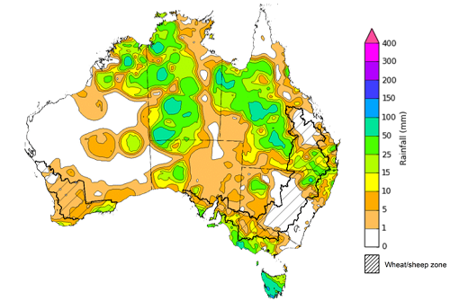
Over the 8-days to 11 November 2021 a series of troughs and low-pressure systems are expected to draw down moist, tropical air across much of northern, central and eastern Australia, resulting in storms and substantial rainfall. Only some isolated parts of Australia, including the far west, are expected to receive little to no rainfall over the next 8 days.
Rainfall totals of between 10 and 50 millimetres are forecast for most of New South Wales, Queensland, Victoria, South Australia, the Northern Territory and Tasmania, as well as the south and east of Western Australia. Rainfall in excess of 50 millimetres is expected in parts of eastern New South Wales, south-east Queensland, eastern Victoria, as well as isolated parts of South Australia, Western Australia and the Northern Territory.
In Australian cropping regions, rainfall totals of between 10 and 50 millimetres are expected across much of New South Wales, Queensland, Victoria, South Australia and southern and central cropping regions of Western Australia. Rainfall totals in excess of 50 millimetres is expected in some cropping regions in eastern New South Wales. Little to no rainfall is forecast for cropping regions in the north of Western Australia during the next 8-days.
The rainfall expected across Queensland and northern New South Wales is likely to assist the establishment of early sown summer crops and boost soil moisture levels. However, the conditions may interrupt further planting activity and harvesting of winter crops in northern growing regions. The wet, humid conditions may also increase the risk of grain quality issues in mature crops. In southern cropping regions, the expected rainfall is likely to improve plant available moisture and support yield potentials as crops progress through grain filling. The rainfall will be of particular value in parts of southern New South Wales, northern Victoria and South Australia, where soil moisture levels are below average to average.
Total forecast rainfall (mm) for the period 4 November to 11 November 2021
Note: This rainfall forecast is produced from computer models. As the model outputs are not altered by weather forecasters, it is important to check local forecasts and warnings issued by the Bureau of Meteorology.
Water
Water storages, water markets and water allocations - current week
The Tableau dashboard may not meet accessibility requirements. For information about the contents of these dashboards contact ABARES.

Commodities
Information on weekly price changes in agricultural commodities is now available at the Weekly commodity price update.