
Key issues
- For the week ending 13 July 2022, the remnant of an East Coast Low brought significant rainfall to isolated parts of eastern Australia, while cold fronts brought moderate rainfall to parts of southern Australia. Meanwhile, high-pressure systems dominated much of the country bringing clear, dry conditions.
- Predominantly dry conditions across New South Wales and Queensland over the past week allowed the harvest of remaining summer crops and final sowing of winter crops to continue. Light to moderate rainfall in Western Australia over the past week will have boosted plant available water, but further rainfall will be required to support ongoing yield development.
- Analysis of oceanic and atmospheric indicators suggest that El Niño-Southern Oscillation (ENSO) conditions remain neutral, reducing its influence on Australia’s climate patterns. Meanwhile, sea surface temperatures in the tropical Indian Ocean suggest the continued development of a negative Indian Ocean Dipole (IOD) event. The Southern Annular Mode (SAM) became strongly positive over the preceding couple of weeks. Given current and expected conditions, the IOD and SAM are likely to be the major influences on late winter and early spring rainfall across Australia.
- The outlook for August 2022 indicates that there is a 75% chance of rainfall totals between 10 and 50 millimetres across much of New South Wales, south-east Queensland, Victoria, southern South Australia, the south-west of Western Australia and Tasmania. Rainfall totals in excess of 100 millimetres are expected across alpine regions of New South Wales and Victoria, as well as the far south-west of Western Australia and western Tasmania.
- Over the 8-days to 21 July 2022, a low-pressure system and associated cold fronts are expected to bring light to moderate rainfall across parts of southern Australia. Rainfalls forecast for cropping regions of Western Australia will be a welcome relief, following several weeks of relatively dry conditions and declining soil moisture levels. For much of the country, high-pressure systems will dominate, resulting in clear, dry conditions.
- Water storage in the Murray–Darling Basin (MDB) decreased by 11 gigalitres (GL) between 6 July 2022 and 13 July 2022. The current volume of water held in storage is 22,224 GL, which represents 88 of total capacity. This is 30% or 5,133 GL more than at the same time last year.
- Allocation prices in the Victorian Murray below the Barmah Choke increased from $26 per ML on 30 June 2022 to $86 per ML on 8 July 2022. Prices are lower in the Goulburn-Broken, Murrumbidgee and regions above the Barmah choke due to the binding of the Murrumbidgee export limit, Goulburn intervalley trade limit and Barmah choke trade constraint. The large increase in prices in all regions is due to the start of the new water year.
Climate
For the week ending 13 July 2022, the remnant of an East Coast Low brought significant rainfall to isolated parts of eastern Australia, while cold fronts brought moderate rainfall to parts of southern Australia. Meanwhile, high-pressure systems dominated much of the country bringing clear, dry conditions.
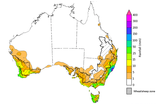
Rainfall totals of between 10 and 50 millimetres were recorded in eastern New South Wales, isolated parts of south-eastern Queensland and South Australia, the east and south of Victoria, the south-west of Western Australia, as well as most of Tasmania. Rainfall totals in excess of 50 millimetres were recorded in isolated parts of eastern New South Wales. Remaining parts of Australia received little to no rainfall.
In Australian cropping regions, rainfall totals of between 10 and 50 millimetres were recorded in isolated parts of north-eastern New South Wales, the central-south of South Australia, as well as southern and western parts of Western Australia. Little to no rainfall was recorded across remaining cropping regions for the week ending 13 July 2022.
Predominantly dry conditions across New South Wales and Queensland over the past week allowed the harvest of remaining summer crops and final sowing of winter crops to continue. The significant rainfall received in New South Wales and Queensland throughout the winter sowing window has inhibited many growers from planting their intended winter program, and further rainfall since the start of July has likely exacerbated waterlogging issues in some areas. However, the rainfall has boosted soil moisture levels and is likely to improve yield potentials for planted crops. Soil moisture levels remain average to above average across cropping regions of New South Wales and Queensland, while soil moisture levels are below average to average in Victoria, South Australia and Western Australia. Light to moderate rainfalls in Western Australia over the past week will have boosted plant available water, but further rainfall will be required to support ongoing yield development.
Rainfall for the week ending 13 July 2022
Throughout the late winter and early spring period the climate drivers with the largest potential impact on Australia’s climate patterns are the El Niño–Southern Oscillation (ENSO), the Indian Ocean Dipole (IOD) and the Southern Annular Mode (SAM). These climate drivers are likely to influence pasture growth across southern Australia and the growth and yield prospects for winter crops.
Analysis of oceanic and atmospheric indicators suggest that ENSO conditions remain neutral, reducing its influence on Australia’s climate patterns. International climate models expect the ENSO to remain neutral throughout winter, with two of the seven models predicting the development of a La Niña event in late spring. Meanwhile, sea surface temperatures in the tropical Indian Ocean suggest the continued development of a negative IOD event. The SAM became strongly positive over the preceding couple of weeks. Given current and expected conditions, the IOD and SAM are likely to be the major influences on late winter and early spring rainfall across Australia.
Sea surface temperature (SSTs) anomalies have been close to average in the tropical Pacific Ocean close to the equator over the previous week. However, small pockets of weak warm anomalies were present along the equator in parts of the eastern equatorial Pacific. SSTs were slightly cooler than average over much of the tropical central and eastern Pacific south of the equator. Neutral Pacific equatorial sea surface temperatures are associated with neutral ENSO conditions.
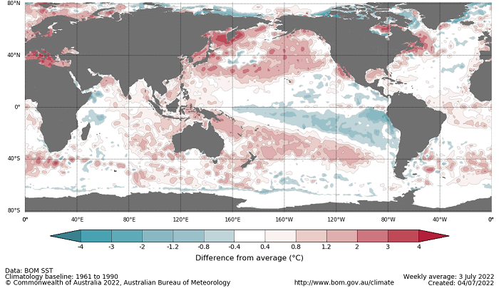
Warm sea surface temperature anomalies continue over the southern Maritime Continent and around much of Australia. The warm anomalies in the eastern Indian Ocean and the ocean surrounding Australia underpin the ongoing development of a potential negative IOD.
Difference from average sea surface temperature observations 27 June to 3 July 2022
A negative IOD event is looking increasingly likely if current conditions in the Indian Ocean persist. Warmer than average water temperatures in the east Indian Ocean and cooler than average temperatures in the west are associated with above average rainfall across southern Australia throughout winter and spring, as well as the far north. It is also associated with the early onset of northern Australia rainfall.
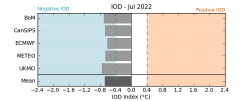
As at 3 July 2022, the Indian Ocean Dipole (IOD) weekly value was -0.69°C. The IOD index has been below the negative IOD threshold (−0.4 °C) for three consecutive weeks prior to this week. While a negative IOD event is not declared until the index has been below the threshold for at least 8 weeks, this pattern can still influence Australian rainfall as the event develops. All international climate models surveyed by the Bureau of Meteorology predict a negative IOD in July. All five models anticipating a negative IOD is likely to persist through August to November.
International climate model outlooks for the IOD index in July 2022
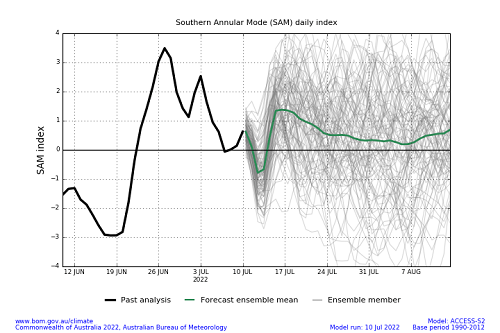
The Southern Annular Mode (SAM) is currently positive, with strongly positive values being recorded over previous weeks. SAM is expected to return to neutral values and remain neutral to positive over the coming weeks. The SAM refers to the north-south shift of the band of rain-bearing westerly winds and weather systems in the Southern Ocean compared to the usual position. A positive SAM in winter is associated with increased rainfall for parts of eastern Australia. It is also associated with decreased rainfall for western and central Victoria, the south-east of South Australia, the west of Western Australia and Tasmania.
Southern Annular Mode (SAM) daily index
These climate outlooks are generated by ACCESS–S (Australian Community Climate Earth-System Simulator–Seasonal). ACCESS–S is the Bureau of Meteorology's dynamic (physics-based) weather and climate model used for monthly, seasonal and longer-lead climate outlooks.
For further information, go to http://www.bom.gov.au/climate/ahead/about/
The Bureau of Meteorology’s latest rainfall outlook indicates wetter than average conditions are expected across the majority of Australia during August. The ACCESS-S climate model suggests there is close to a 60% chance of exceeding median for most of Australia, with below median rainfall likely for western Tasmania the far south-east of South Australia, and part of south-western Victoria and Western Australia.
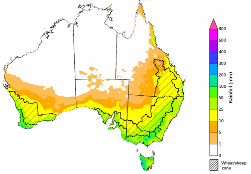
The outlook for August 2022 indicates that there is a 75% chance of rainfall totals between 10 and 50 millimetres across much of New South Wales, south-east Queensland, Victoria, southern South Australia, the south-west of Western Australia and Tasmania. Rainfall totals in excess of 100 millimetres are expected across alpine regions of New South Wales and Victoria, as well as the far south-west of Western Australia and western Tasmania.
Across cropping regions there is a 75% chance of rainfall totals of between 25 and 50 millimetres across eastern New South Wales, southern Victoria, western and central South Australia and parts of Western Australia. There is a 75% chance of rainfall less than 25 millimetres for northern and western New South Wales, northwest Victoria, parts of eastern South Australia, most of Queensland, and central and eastern cropping regions in Western Australia.
Rainfall totals that have a 75% chance of occurring August 2022
The rainfall outlook for August to October 2022 suggests there is a greater than 75% chance of exceeding median rainfall across most of New South Wales, Queensland, parts of South Australia, northern Victoria, as well as the Northern Territory. For remaining regions of Australia, there is an increased chance of above median rainfall, except for parts of southwestern Western Australia and western Tasmania where below median rainfall is likely between August to October 2022 (Bureau of Meteorology ‘National Climate Outlook’, 7 July 2022).
Bureau of Meteorology rainfall outlooks for August to October have greater than 55% past accuracy across most of Australia. Outlook accuracy is greater than 65% across large areas of northern and eastern Australia. Past accuracy is low (less than 50%) for parts of inland southern Western Australia extending into southern South Australia, and for parts of southern Tasmania.
Chance of exceeding the median rainfall August to October 2022
![Map showing the chance of exceeding median rainfall between August to October 2022 in Australia. Image provided by the Bureau of Meteorology. Please refer to accompanying text for a more detailed description.]](/sites/default/files/images/rain.forecast.median.national.season1.latest.hr__16.png)
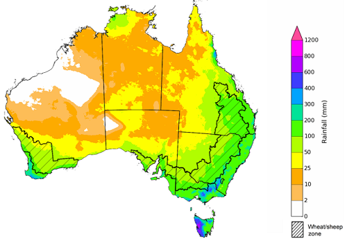
The outlook for August to October 2022 suggests there is a 75% chance of rainfall totals between 50 and 200 millimetres across much of New South Wales, south-eastern Queensland, Victoria, southern parts of South Australia, the south-west of Western Australia and Tasmania. Rainfall totals in excess of 200 millimetres are forecast for alpine regions of New South Wales and Victoria, far south-west Western Australia, and western and northern Tasmania.
Across cropping regions, there is a 75% chance of receiving between 50 and 100 millimetres across parts of western New South Wales, northern and western Queensland, northern Victoria, parts of South Australia and much of Western Australia. Totals of between 100 and 200 millimetres are expected across much of New South Wales, Queensland, southern Victoria, central South Australia and the far west and south of Western Australia.
Root zone soil moisture levels are average to above average across much of the Wheat/sheep zone but below average to average across parts of Western Australia. There is a high—75%—chance that forecast rainfall totals across Western Australian cropping regions will be sufficient to support the growth of winter crops during the August to October period. In remaining cropping regions, the expectation of above average rainfall over the next three months increases the risk of waterlogging adversely affecting crop growth and development, particularly in areas with above average soil moisture levels for this time of year.
Rainfall totals that have a 75% chance of occurring August to October 2022
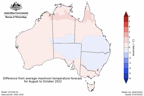
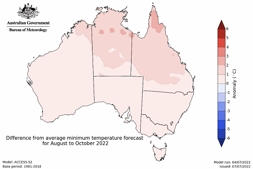
The temperature outlook for August to October 2022 indicates that maximum temperatures across most of Australia are likely to be close to the 1990-2012 average (the difference in the range of - 1°C to +1°C), with slightly higher than average temperatures across the tropical north. Minimum temperatures are expected to be slightly above average for much of the northern Australia, and close to average for the rest of Australia (Bureau of Meteorology ‘National Climate Outlook’, 7 July 2022).
Predicted maximum temperature anomaly for August to October 2022
Predicted minimum temperature anomaly for August to October 2022
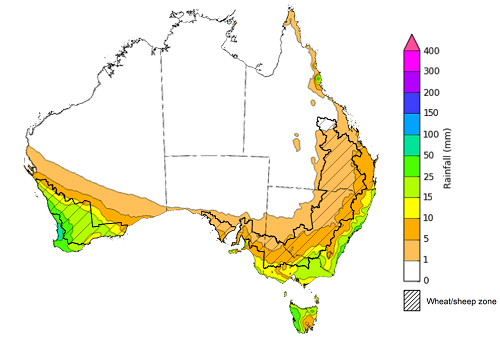
Over the 8-days to 21 July 2022, a low-pressure system and associated cold fronts are expected to bring light to moderate rainfall across parts of southern Australia. For much of the country, high-pressure systems will dominate, resulting in clear, dry conditions.
Rainfall totals of between 10 and 50 millimetres are forecast for isolated parts of eastern and southern New South Wales and Victoria, isolated parts of north Queensland, the south-east of South Australia and the south-west of Western Australia, as well as much of Tasmania. Rainfall totals in excess of 50 millimetres are forecast for isolated parts of the south-west of Western Australia. Little to no rainfall is forecast across remaining parts of Australia over the next 8-days.
In Australian cropping regions, rainfall totals of between 10 and 50 millimetres are expected across parts of southern New South Wales and Victoria, as well as most of Western Australia. Little to no rainfall is forecast for all remaining cropping regions during the next 8-days.
Dry conditions forecast across New South Wales and Queensland will allow growers to harvest what remains of summer crops, as well as the late planting of winter cereal crops. For most growers in eastern Australia who planted winter crops in the typical planting window, the dry conditions will allow field access for crop management activities. The rainfall forecast for cropping regions of Western Australia will be a welcome relief, following several weeks of relatively dry conditions and declining soil moisture levels.
Winter crops in Western Australia have had a favourable start to the season, with substantial rainfall early in the season and above average temperatures throughout June. The rainfall expected over the coming week will boost soil moisture levels across Western Australian cropping regions and support continued crop development. The outlook through spring is also expected to provide sufficient rainfall to support yield potentials as the crop enters critical stages of flowering and grain filling.
Total forecast rainfall (mm) for the period 14 July to 21 July 2022
Water
Water storages, water markets and water allocations - current week
The Tableau dashboard may not meet accessibility requirements. For information about the contents of these dashboards contact ABARES.

Commodities
Information on weekly price changes in agricultural commodities is now available at the Weekly commodity price update.