
Key issues
- In the week ending 27 March 2024, widespread rainfall and isolated thunderstorms associated with monsoonal activity, ex-Tropical Cyclone Megan, and series of troughs were recorded across northern, central and eastern Australia.
- Across cropping regions, rainfall totals up to 150 millimetres were recorded across Queensland and up to 100 millimetres recorded across parts of northern New South Wales. Heavy falls in Queensland would have disrupted harvest of summer crops.
- Over the coming days, showers and storms associated with a low-pressure system are expected to result in rainfall totals of up to 100 millimetres in the northern tropics and up to 50 millimetres in the central and eastern parts of the country.
- A wet week in much of Queensland’s cropping region will likely interrupt harvest of summer crops but boost soil moisture levels for winter crops, including in Victoria and New South Wales.
- A drier week is expected in remaining cropping regions and will likely see a decline in soil moisture levels.
- The national rainfall outlook is for a heightened probability of below average rainfall for much of Australia over the next three months.
- Considering the recent declines in upper layer soil moisture levels and the heightened probability of below average rainfall over the next three months, livestock producers, especially those in southern Australia, are expected to experience below-average pasture production.
- However, availability of accumulated standing dry matter and ample conserved fodder is likely to enable most livestock producers to maintain current production levels and stocking rates.
- Water storage levels in the Murray-Darling Basin (MDB) decreased between 21 March 2024 and 28 March 2024 by 152 gigalitres (GL). Current volume of water held in storage is 17 114 GL, equivalent to 77% of total storage capacity. This is 13 percent or 2645 GL less than at the same time last year.
- Allocation prices in the Victorian Murray below the Barmah Choke increased from $30 on 21 March 2024 to $37 on 28 March 2024. Prices are lower in the Murrumbidgee and regions above the Barmah choke due to the binding of the Murrumbidgee export limit and Barmah choke trade constraint.
Climate
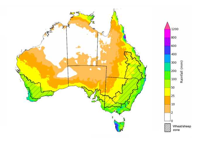
For the week ending 27 March 2024, widespread rainfall of up to 400 millimetres and isolated thunderstorms associated with monsoonal activity and ex-Tropical Cyclone Megan were recorded across northern Australia. A series of troughs moved across eastern parts of the country, bringing moderate rainfall totals. High-pressure systems in the south kept South Australia, Victoria and Western Australia and southern parts of New South Wales generally dry.
In Tasmania, a cold front brought rainfall to the west coast exceeding 50 millimetres in some areas.
Across cropping regions, rainfall totals up to 150 millimetres were recorded across Queensland and up to 100 millimetres recorded across parts of northern New South Wales. Heavy falls in Queensland would have disrupted harvest of summer crops. No rainfall was recorded across remaining cropping areas and would rely on autumn break to prepare the soil moisture levels for winter crops.
Rainfall for the week ending 27 March 2024
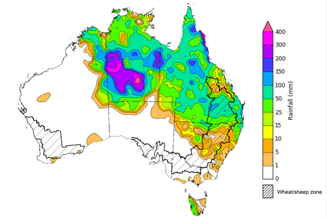
Issued: 27/03/2024
Note: The rainfall analyses and associated maps utilise data contained in the Bureau of Meteorology climate database, the Australian Data Archive for Meteorology (ADAM). The analyses are initially produced automatically from real-time data with limited quality control. They are intended to provide a general overview of rainfall across Australia as quickly as possible after the observations are received. For further information go to http://www.bom.gov.au/climate/rainfall/
Over the 8 days to 4 April 2024, showers and storms associated with a low-pressure system are expected to result in rainfall totals of up to 100 millimetres in the northern tropics and up to 50 millimetres in the central and eastern parts of the country. A high-pressure system is expected to keep the west generally dry. A cold front is expected to bring rainfall totals of up to 25 millimetres in Tasmania and 50 millimetres in Victoria.
Across cropping regions, rainfall totals of up to 50 millimetres are forecast for central Queensland cropping regions and up to 25 millimetres across New South Wales and Victoria. Little to no rainfall is expected in the remaining cropping areas. Rainfall in Queensland is likely to disrupt harvest of summer crops. Dry conditions in Western Australia will likely see a decline in soil moisture levels.
Total forecast rainfall for the period 28 March to 4 April 2024
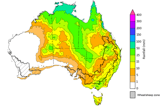
Issued 28/03/2024
Note: This rainfall forecast is produced from computer models. As the model outputs are not altered by weather forecasters, it is important to check local forecasts and warnings issued by the Bureau of Meteorology.
The most recent rainfall outlook for April 2024 provided by the Bureau of Meteorology indicates a high likelihood (60 to 80% chance) of below-median rainfall across a significant portion of Australia. Notable exceptions being southern Tasmania, and eastern parts of Queensland, which are showing a probability of slightly above median rainfall.
According to Bureau of Meteorology’s climate model, there is a 75% probability of rainfall totals up to 200 millimetres in western Tasmania, and parts of northern coastal Queensland for April 2024. Up to 100 millimetres of rainfall is likely in coastal parts of New South Wales, Victoria, and the northern tropics.
Within cropping regions, there is at least 75% chance of rainfall totals up to 25 millimetres expected along the eastern fringes of New South Wales, Victoria, and parts of Queensland. The remaining cropping regions have a 75% chance of receiving up to 10 millimetres of rainfall.
A lack of sufficient rainfall in April is likely to result in an increased disconnect between upper- and lower-layer soil moisture, meaning that there would be limited opportunities to plant winter crops under ideal conditions. This may see many grain producers opt to dry sow crops, which presents some production risk outcomes if May rainfall is not sufficient to support germination and establishment.
Rainfall totals that have a 75% chance of occurring in April 2024
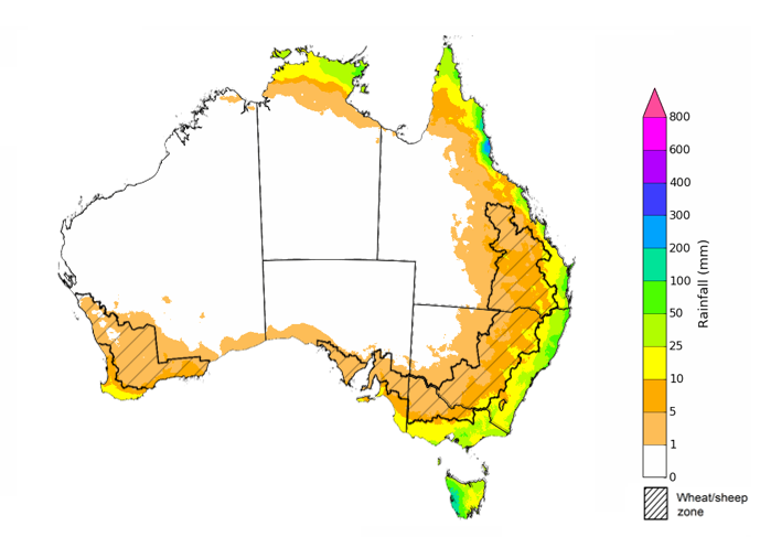
Issued: 28/03/2024
The El Niño event of 2023 is nearing its end, with the anticipation of returning to neutral ENSO conditions during the current 2024 autumn. The rainfall outlook for April through June 2024 indicates a probability of below-median rainfall across much of Australia.
Across cropping regions, there is an equal chance of rainfall being above median in Queensland and northern New South Wales. Below median rainfall is expected in the remaining cropping areas. This presents a risk for declining upper layer moisture levels that is necessary for winter crop plantings.
Chance of exceeding the median rainfall April to June 2024
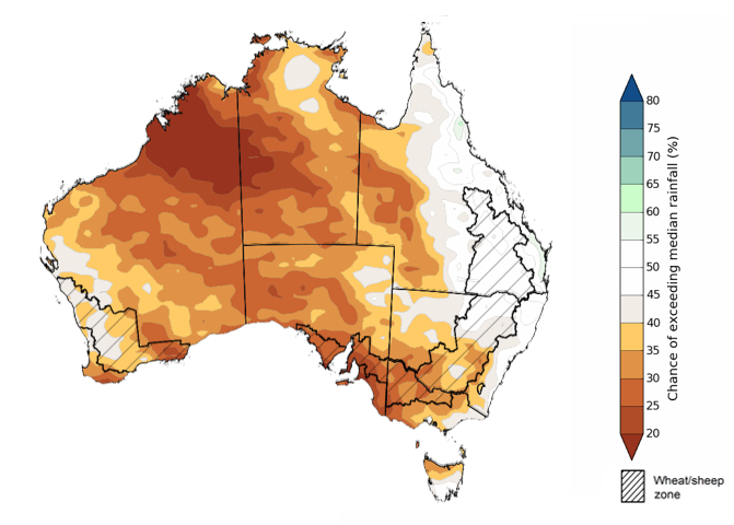
Issued: 28/03/2024
The outlook for April to June 2024 suggests there is at least 75% chance of rainfall exceeding 25 millimetres throughout much of southern and eastern Australia, with notable exceptions in large sections of the interior and northern regions where rainfall below 25 millimetres is more likely. Along isolated parts of Australia’s eastern and southern coastline, as well as western Tasmania, rainfall totals in excess of 200 millimetres are expected during this period.
Across cropping regions, there is at least a 75% chance of receiving 25 millimetres or more.
Considering the recent declines in upper layer soil moisture levels and the heightened probability of below average rainfall over the next three months, livestock producers, especially those in southern Australia, are expected to experience below-average pasture production. However, the availability of accumulated standing dry matter and ample conserved fodder is likely to enable most producers to maintain current production levels and stocking rates.
Rainfall totals that have a 75% chance of occurring April to June 2024
Issued: 28/03/2024
Water
Water storages, water markets and water allocations - current week
The Tableau dashboard may not meet accessibility requirements. For information about the contents of these dashboards contact ABARES.

Commodities
Information on weekly price changes in agricultural commodities is now available at the Weekly commodity price update.