
Key issues
- During the week ending 29 September 2021, a trough of low-pressure systems resulted in rainfall in parts of eastern Australia, while a cold front off the Southern Ocean brought substantial rainfall to western Tasmania. Weak frontal activity across northern and central Australia, on the other hand, brought clear, dry conditions.
- Crops remain in good condition across most growing regions, but further rainfall will support crops through grain filling and enhanced yields. Some parts of Victoria, South Australia and Western Australia had little to no rainfall through September and hence a rapid drying of soils, which will negatively affect yields. Rainfall in parts of central Queensland will support sprouting and establishment of early-sown summer crops. Continued rainfall will boost soil moisture levels and encourage increased planting activity.
- The climate driver with the largest potential impact on summer rainfall across much of Australia is the El Niño-Southern Oscillation (ENSO). The ENSO is currently neutral. However, the Bureau of Meteorology recently updated its ENSO Outlook from ‘inactive’ to ‘La Niña watch’, reflecting the increased likelihood of a La Niña event forming over the coming months. La Niña events are associated with above average rainfall in eastern, central and northern Australia in spring and summer.
- Troughs of low-pressure systems across eastern and southern Australia and cold fronts in the southwest are expected to result in significant rainfall across those regions. High pressure systems across central and northern parts of Australia are likely to bring clear skies and dry conditions over the next eight days.
- Water storage in the Murray–Darling Basin (MDB) increased by 69 gigalitres (GL) between 22 September 2021 and 29 September 2021. The current volume of water held in storage is 21,554 GL, which represents 85% of total capacity. This is 48% or 7,019 GL more than at the same time last year.
- Allocation prices in the Victorian Murray below the Barmah Choke decreased from $139 per ML on 17 September 2021 to $125 per ML on 24 September 2021. Prices are lower in the Goulburn-Broken, Murrumbidgee, and regions above the Barmah choke due to the binding of the Goulburn intervalley trade limit, Murrumbidgee export limit, and Barmah choke trade constraint.
Climate
[expand all]
Rainfall this week
During the week ending 22 September 2021, high pressure systems and weak frontal activity across southern Australia resulted in little rainfall across much of the continent. Weak frontal systems brought rainfall to western Tasmania, parts of southern New South Wales, southern Victoria, the far southeast of South Australia and the southwest of Western Australia. Isolated thunderstorms developed near a surface trough and produced moderate falls over parts of central Australia.
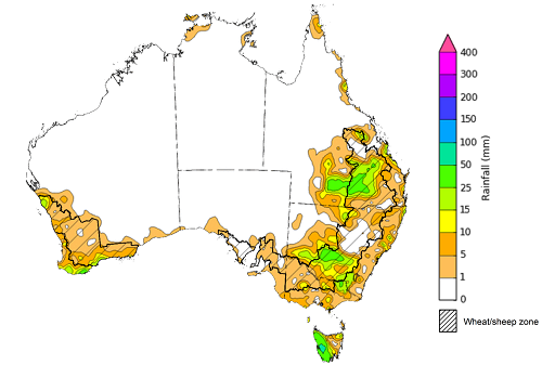
During the week ending 29 September 2021, a trough of low-pressure systems resulted in rainfall in parts of eastern Australia, while a cold front off the Southern Ocean brought substantial rainfall to western Tasmania. Weak frontal activity across northern and central Australia, on the other hand, brought clear, dry conditions.
Rainfall totals of between 10 and 50 millimetres were recorded across southern New South Wales, southern and central Queensland, as well as isolated parts of Victoria, the southwest of Western Australia and parts of Tasmania. Rainfall totals in excess of 50 millimetres were recorded across parts of western Tasmania.
In cropping regions, rainfall totals of between 10 and 50 millimetres were recorded across much of southern New South Wales, central and western Queensland, as well as isolated parts of southern Victoria and Western Australia. Little to no rainfall was recorded in other cropping regions in New South Wales, Queensland, Victoria and Western Australia, as well as most cropping regions in South Australia.
The rainfall in some Queensland cropping regions has interrupted harvesting, but likely benefitted yield potential for crops in southern New South Wales. Crops remain in good condition across most growing regions, but further rainfall will support grain filling and enhanced yields. Some parts of Victoria, South Australia and Western Australia had little to no rainfall through September and hence a rapid drying of soils, which will negatively affect yields. Rainfall in parts of central Queensland will support sprouting and establishment of early-sown summer crops. Continued rainfall will boost soil moisture levels and encourage increased planting activity.
Rainfall for the week ending 29 September 2021
©Commonwealth of Australia 2021, Australian Bureau of Meteorology - Issued: 29/09/2021
Note: The rainfall analyses and associated maps utilise data contained in the Bureau of Meteorology climate database, the Australian Data Archive for Meteorology (ADAM). The analyses are initially produced automatically from real-time data with limited quality control. They are intended to provide a general overview of rainfall across Australia as quickly as possible after the observations are received. For further information go to http://www.bom.gov.au/climate/rainfall/
La Niña watch
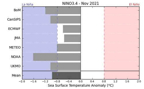
The climate driver with the largest potential impact on summer rainfall across much of Australia is the El Niño-Southern Oscillation (ENSO). The ENSO is currently neutral. However, the Bureau of Meteorology recently updated its ENSO Outlook from ‘inactive’ to ‘La Niña watch’, reflecting the increased likelihood of a La Niña event forming over the coming months. La Niña events are associated with above average rainfall in eastern, central and northern Australia in spring and summer.
The Bureau of Meteorology was prompted to update its ENSO Outlook due to continued cooling of sea surface temperatures across the equatorial Pacific and recent model outlooks. Five of the seven climate models surveyed by the bureau are forecasting the development of a La Niña event by November 2021. Three of the seven models expect the event to last until January 2022.
Throughout winter 2021, a negative Indian Ocean Dipole (IOD) has contributed to above average rainfall for southern and eastern cropping regions. However, the influence of the IOD is expected to diminish with the onset of the northern monsoon season. If a La Niña event does occur, it is likely to boost yields of summer crops across northern cropping regions and improve soil moisture levels in southern cropping regions ahead of next season.
International climate model outlooks for the NINO 3.4 region in November 2021
©Commonwealth of Australia 2021, Australian Bureau of Meteorology - Issued: 28/09/2021
Rainfall forecast for the next eight days
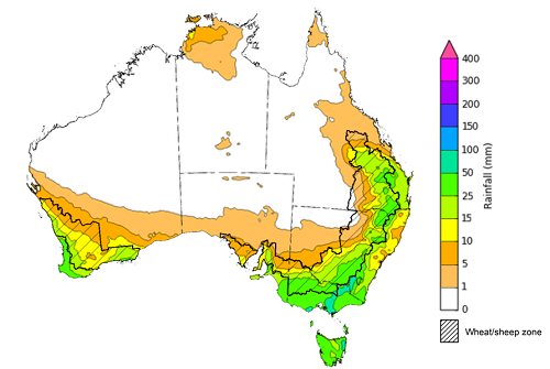
Troughs of low-pressure systems across eastern and southern Australia and cold fronts in the southwest are expected to result in significant rainfall across those regions. High pressure systems across central and northern parts of Australia are likely to bring clear skies and dry conditions over the next eight days.
Rainfall totals of between 10 and 50 millimetres are forecast for much of eastern New South Wales, Victoria and Tasmania, as well as south-east Queensland, the south of South Australia and the south-west of Western Australia. Rainfall in excess of 50 millimetres is expected in alpine regions of New South Wales and Victoria, and the north-east of Tasmania.
In Australian cropping regions, rainfall totals of between 10 and 50 millimetres are expected across southern and north-eastern New South Wales, eastern and central Queensland, southern and central parts of South Australia, southern and western parts of Western Australia, as well as much of Victoria. Lower rainfall totals of between 5 and 10 millimetres are expected across north-western New South Wales, western and northern Queensland, as well as the northern cropping regions of South Australia and Western Australia during the next 8 days.
The forecast rainfall across most cropping regions will boost soil moisture levels and support yield potentials, as winter crops progress through flowering and grain filling. A lack of rainfall throughout much of September has led to a decrease in plant-available moisture. However, the wet winter in most cropping regions has resulted in above-average soil moisture levels, which have supported ongoing crop development through spring. For parts of South Australia and Western Australia, rapid drying of soil profiles is negatively affecting yield potential, and the forecast rainfall is unlikely to provide relief. In Queensland, wet conditions are likely to interrupt harvesting of winter crops but provide an impetus for increased planting of summer crops when conditions allow.
Total forecast rainfall (mm) for the period 30 September to 7 October 2021
©Commonwealth of Australia 2021, Australian Bureau of Meteorology - Issued: 29/09/2021
Note: This rainfall forecast is produced from computer models. As the model outputs are not altered by weather forecasters, it is important to check local forecasts and warnings issued by the Bureau of Meteorology.
Water
Water storages, water markets and water allocations - current week
The Tableau dashboard may not meet accessibility requirements. For information about the contents of these dashboards contact ABARES.
