
The Future Drought Fund (FDF) is the key investment by the Australian Government to build drought resilience in Australia’s agriculture sector, the agricultural landscape, and communities. The FDF Monitoring Evaluation and Learning (MEL) Framework, outlines the rationale, scope and approach for monitoring and evaluating the FDF, including setting a range of high-level indicators to monitor drought resilience. These indicators are categorised under the strategic priorities of the FDF:
- Economic resilience for an innovative and profitable agricultural sector
- Environmental resilience for sustainable and improved functioning of farming landscapes
- Social resilience for resourceful and adaptable communities.
To support ongoing monitoring and evaluation of the FDF ABARES has contributed a range of data and research products, a number of which are being used under the FDF MEL as indicators of economic, environmental and social resilience, including:
- Farm business drought risk indicators
- Climate-adjusted farm Total Factor Productivity
- Natural Resource Management and Drought Resilience survey of farm practices
- Community vulnerability and resilience to drought index (CVRDI)
- Ground cover indicator
The terms 'resilience', ‘sensitivity’ and ‘vulnerability’ have a range of interpretations. Under the conceptual framework adopted by ABARES potential drought impact (risk) is defined as a function of drought exposure (i.e., climate variability) and sensitivity (for more detail see the Measuring drought risk and Potential drought impact indicators for farms and communities reports).
Drought vulnerability and resilience conceptual framework
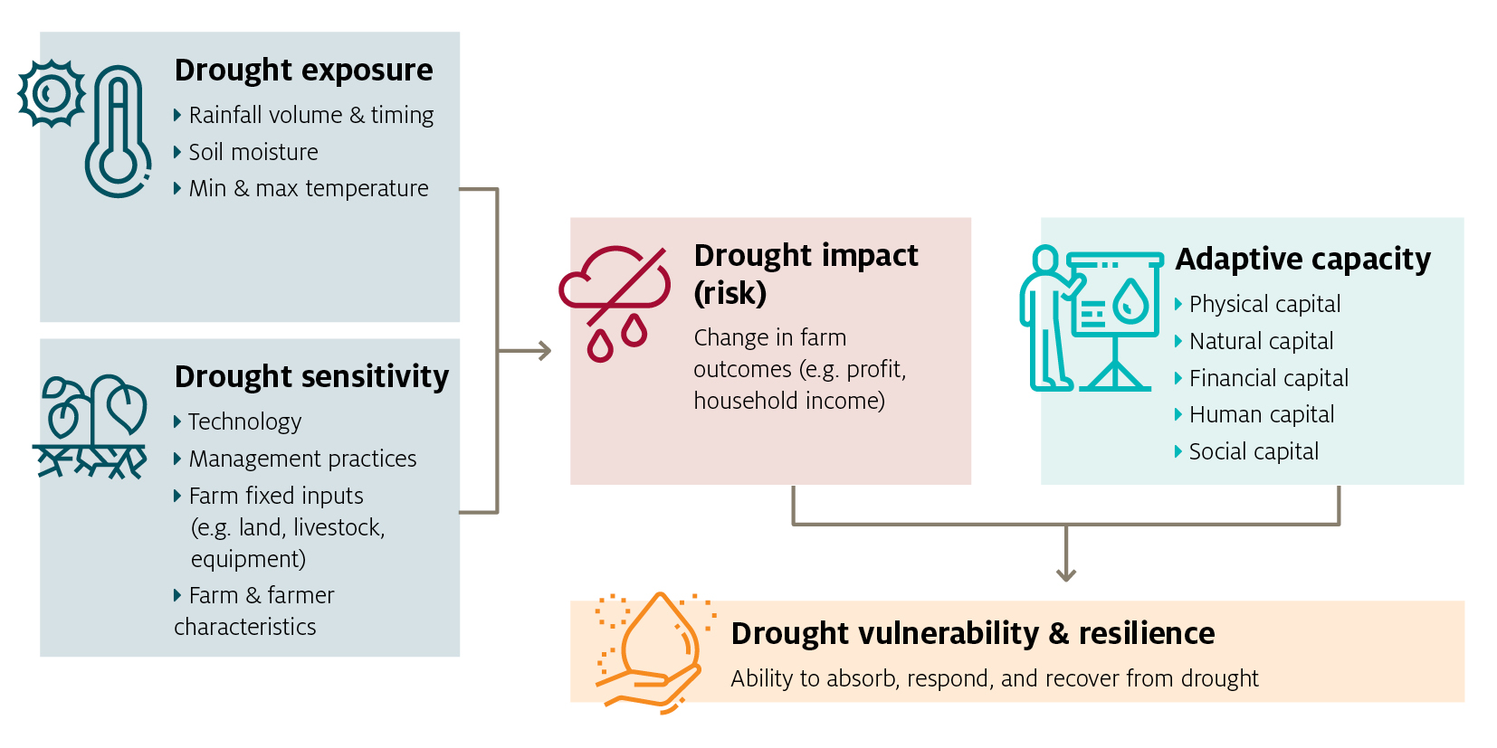
Drought resilience is then a measure of a system’s ability to absorb, respond and recover to drought risk which is a product of the size of the risk, as well the capacity of the system to adapt. Many of the indicators produced recently by ABARES attempt to estimate potential drought impact (risk) only. Development of the measures of adaptive capacity remain a subject for future research.
These indicators may help to inform monitoring and evaluation of drought resilience programs by, for example, tracking trends in the drought sensitivity of farms, communities, or regions over time. However, as each indicator can be influenced by a wide range of factors, isolating the casual effects of any specific program or intervention remains difficult.
Further information on these indicators is available below.
The Measuring drought risk report presents a methodology for measuring the effect of drought on the profits of farms, using ABARES farmpredict model. With this approach, farmpredict is applied to isolate the effects of climate variability from other factors that also affect farm outcomes. Drought risk for each farm can then be measured as the difference in outcomes between a ‘drought’ year (1-in-10 poor climate year) and ‘normal’ year (5-in-10 / median year).
These drought risk measures identify differences in farm sensitivity and exposure across locations and farm types. For example, in-land areas with hotter and drier conditions are generally exposed to greater drought risk than high rainfall coastal zones. Further, more diversified farms (with a mix of livestock and cropping activity) face less drought risk compared with cropping specialists.
The indicators also provide an assessment of long-term change in drought sensitivity of the farm sector over time, which can reflect a combination of factors including changes in industry structure (i.e., the mix of cropping and livestock activity), changes in technology and management practices and commodity prices.
Measuring drought risk report
Download
Drought risk results 2021 (XLSX 2.9 MB)
If you have difficulty accessing these files, visit web accessibility for assistance.
Social resilience is a priority in understanding and measuring the potential impacts of drought on communities.
ABARES prepared a national index that ranks remote, rural or regional agriculturally dependent communities (at the Local Government Area (LGA) level) according to their potential to be adversely affected by drought. These indicators account for both agriculture industry exposure and sensitivity (based on the above farm business drought risk indicators) and community sensitivity: using ABS Census of Population and Housing 2021 data to represent the level of community dependence on agriculture.
ABARES developed a dashboard for visualising the outputs of the national index. The dashboard generates an ordinal (0 to 1) ranking of agriculturally dependent communities based on their potential to be impacted by drought. The most sensitive LGAs (with both high farm drought risk and high agricultural dependence) receive a ranking near 1 and the least (with both low farm drought risk and low agricultural dependence) receive a rating near 0.
The below report outlines the conceptual framework and the approach taken to generate the indicators.
These indicators represent a first stage of work in the development of a broader capability in ABARES to better understand community resilience to drought.
Download the report
Community vulnerability and resilience to drought index — stage 1 - MS Word [1.71 MB]
Community vulnerability and resilience to drought index — stage 1 - PDF [0.97 MB]
One indicator identified under the FDF environmental resilience priority is ground cover (total vegetation cover). Ground cover is a recognised important biophysical process indicator that can suggest landscape health, function, and soil condition. Higher levels of ground cover can provide benefits before, during or post drought, through erosion protection, enabling water infiltration and soil carbon retention.
ABARES has prepared a dashboard displaying monthly vegetation cover and trends across Australia to infer soil erosion risk. The dashboard presents for Natural Resource Management (NRM) Regions:
- A national annual overview of vegetation cover targets for agricultural land protected from soil erosion each year
- Monthly time series charts of agricultural land protected from soil erosion by month.
This indicator can be interpreted as a measure of environmental drought sensitivity: in periods when ground cover is low the landscape is likely to be more sensitive to future drought events. Current ground cover levels are influenced by historical weather conditions, farming management practices, and natural resource management activities.
This project complements other ABARES and CSIRO Ground cover monitoring work under the National Landcare Program Regional Land Partnerships which is using vegetation cover as an indicator of soil at risk of wind and water erosion.