Skip to main content Skip to main navigation Skip to search
ABARES - Land use and management

Top navigation abares

  • Department
  • Ministers
  • Media Centre
Main menu

Main navigation ACLUMP

  • Land home
    Land home
  • About ACLUMP
    About ACLUMP
  • Land use
    Land use
  • Publications
    Publications
  • Data download
    Data download
  • Latest news
    Latest news
Department of Agriculture

Breadcrumb

  1. DAFF Home
  2. ABARES
  3. Land use and management
  4. Land use
  5. 1992-93, 1993-94, 1996-97, 1998-99, 2000-01 and 2001-02 Land Use of Australia, Version 3

Secondary ACLUMP

  • Land use
    • Land use mapping
    • Catchment scale land use of Australia and Commodities – Update December 2023
    • Catchment scale land use profiles
    • Mapping technical specifications
    • Land use apps
    • Data download
    • Publications
    • Australian Land Use and Management Classification
      • ALUM Classification Version 8 (October 2016)
    • Australian Agricultural Census 2020–21 visualisations
    • Land use of Australia 2010–11 to 2020–21

1992-93, 1993-94, 1996-97, 1998-99, 2000-01 and 2001-02 Land Use of Australia, Version 3

Publication date: 21 September 2006

Land Use of Australia, Version 3, is a series of land use maps of Australia for the years 1992/93, 1993/94, 1996/97, 1998/99, 2000/01 and 2001/02.

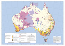
Agricultural land uses and their spatial distributions are based on the Australian Bureau of Statistics' agricultural census and survey data. The spatial distribution of the agricultural land uses is modelled and was determined using Advanced Very High Resolution Radiometer (AVHRR) satellite imagery with training data to make agricultural land use allocations. The non-agricultural land uses are drawn from existing digital maps covering seven themes: topographic features, catchment scale land use, protected areas, World Heritage Areas, tenure, forest type and vegetation condition.

The maps are supplied as a set of ARC/INFO (Trademark) grids with geographical coordinates referred to GDA94 and 0.01 degree cell size. For each of the years mapped there is a set of probability maps, one for each agricultural land use and a single summary map showing the non-agricultural land uses and a likely arrangement of the agricultural land uses.

The arrangement of agricultural land uses in the summary map was determined from the probability maps using some simple rules to make an approximation to a maximum likelihood land use map. As supplied, the probability maps are floating point grids with cell value between 0 and 1 and no value attribute table while the summary map is an integer grid with a value attribute table with attributes defining the agricultural commodity group, irrigation status and land use according to the Australian Land Use and Management Classification (ALUMC), Version 5.

Prospective users of the data should note the caveats and additional metadata, which are included in the document entitled 'User Guide and Caveats: 1992/93, 1993/94, 1996/97, 1998/99, 2000/01 and 2001/02 Land Use of Australia, Version 3'.

Map of national land use in 1992-93


Downloads

Data

Land Use of Australia 1992-93, 1993-94, 1996-97, 1998-99, 2000-01 and 2001-02 - National map - integer compressed raster package (ESRI grid) ZIP [6.2 MB]

Land Use of Australia 1992-93, 1993-94, 1996-97, 1998-99, 2000-01 and 2001-02 - User Guide and Caveats PDF [236 KB]

Land Use of Australia 1992-93, 1993-94, 1996-97, 1998-99, 2000-01 and 2001-02 - User Guide and Caveats DOC [328 KB]

Land Use of Australia 1992-93, 1993-94, 1996-97, 1998-99, 2000-01 and 2001-02 - Metadata ZIP [20 KB]

General Downloads

Land Use of Australia 1996-97 - Summary statistics PDF [35 KB]

Land Use of Australia 2000-01 - Summary statistics PDF [14 KB]

Land Use of Australia 2001-02 - Summary statistics PDF [35 KB]

Land Use of Australia 1992-93 - Land use map based on the secondary level classes of ALUMC Version 5 PDF [4.4 MB]

Land Use of Australia 1993-94 - Land use map based on the secondary level classes of ALUMC Version 5PDF [4.4 MB]

Land Use of Australia 1996-97 - Land use map based on the secondary level classes of ALUMC Version 5 PDF [4.2 MB]

Land Use of Australia 1998-99 - Land use map based on the secondary level classes of ALUMC Version 5 PDF [4.3 MB]

Land Use of Australia 2000-01 - Land use map based on the secondary level classes of ALUMC Version 5 PDF [4.4 MB]

Land Use of Australia 2001-02 - Land use map based on the secondary level classes of ALUMC Version 5 PDF [4.4MB]

Technical report 2006: National Land Use Maps: 1992/93, 1993/94, 1996/97, 2000/01, 2001/02 Version 3, Knapp S, Smart R, Barodien G. [PDF 1.1KB]

Thanks for your feedback.
Thanks! Your feedback has been submitted.

We aren't able to respond to your individual comments or questions.
To contact us directly phone us or submit an online inquiry

CAPTCHA
This question is for testing whether or not you are a human visitor and to prevent automated spam submissions.

Please verify that you are not a robot.

Skip
Page last updated: 10 January 2023

We acknowledge the continuous connection of First Nations Traditional Owners and Custodians to the lands, seas and waters of Australia. We recognise their care for and cultivation of Country. We pay respect to Elders past and present, and recognise their knowledge and contribution to the productivity, innovation and sustainability of Australia’s agriculture, fisheries and forestry industries.

Artwork: Protecting our Country, Growing our Future
© Amy Allerton, contemporary Aboriginal Artist of the Gumbaynggirr, Bundjalung and Gamilaroi nations.

Footer

  • Contact us
  • Accessibility
  • Disclaimer
  • Privacy
  • FOI

© Department of Agriculture, Fisheries and Forestry

Facebook X LinkedIn Instagram