Skip to main content Skip to main navigation Skip to search
ABARES - Land use and management

Top navigation abares

  • Department
  • Ministers
  • Media Centre
Main menu

Main navigation ACLUMP

  • Land home
    Land home
  • About ACLUMP
    About ACLUMP
  • Land use
    Land use
  • Publications
    Publications
  • Data download
    Data download
  • Latest news
    Latest news
Department of Agriculture

Breadcrumb

  1. DAFF Home
  2. ABARES
  3. Land use and management
  4. Land use
  5. Land use apps

Secondary ACLUMP

  • Land use
    • Land use mapping
    • Catchment scale land use of Australia and Commodities – Update December 2023
    • Catchment scale land use profiles
    • Mapping technical specifications
    • Land use apps
    • Data download
    • Publications
    • Australian Land Use and Management Classification
      • ALUM Classification Version 8 (October 2016)
    • Australian Agricultural Census 2020–21 visualisations
    • Land use of Australia 2010–11 to 2020–21

Land use survey app

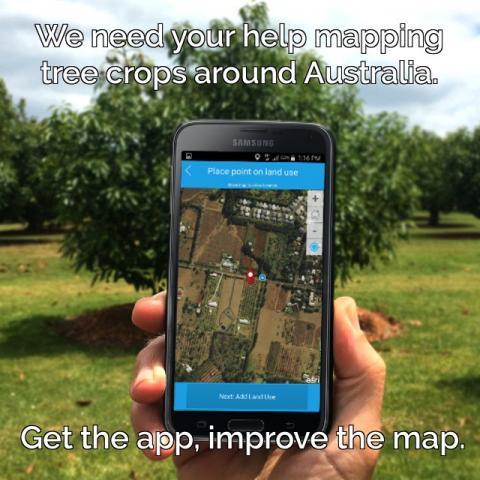
The land use survey is an online form that uses remote sensing (satellite imagery) to capture the location of horticulture tree crops across Australia. The surveys submitted assist in the mapping of avocado, macadamia, mango and citrus orchards; olive groves and banana plantations.

The app enables the capture of ‘citizen science data’ from project partners, industry experts and citizens in a reliable and easy-to-use application. The Land Use Survey App was developed by ​the Queensland Land Use Mapping Program (QLUMP) as a part of Horticulture Innovation Australia’s (HIA) National Tree Project. The initiative is now led by the UNE research team from the Applied Agricultural Remote Sensing Centre (AARSC) and is funded by Hort Innovation, in collaboration with various other universities, state and federal government agencies, private sector companies and industry.

The Land Use Survey App captures on-ground observations made by growers and the general public. The simple interface allows users to capture a location, add comments and add a photograph to assist in identifying tree crops around the country.

University of New England Land Use Survey App

Image of land survey app on mobile phone

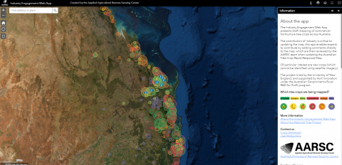
Industry engagement web map

A web map interface has been created for industry experts, stakeholders and the wider public to review the draft mapping and contribute valuable comments to inform the mapping. The spatial data from these two products will greatly inform the mapping of avocado, banana, citrus, macadamia, mango and olive tree crops, especially when classifying one tree crop from another.

Screenshot of industry engagement web app

Data helping industry

  • Australian Bushfire Rapid Response Map (January 2020)
  • Growers urged to get the app to improve the map (HIA media release May 2017)
  • Rapid response tool to protect Aussie farms (HIA media release November 2017)

Collaboration in action

Horticulture Innovation Australia’s (HIA) National Tree Project is an excellent example of a collaborative project involving State Government departments, Universities and industry bodies. Participating stakeholder groups are federally funded through the Rural R&D for Profit program.

Links

Industry Engagement Web Map

National Tree Project

Land Use Survey App

​About Land Use Survey App

Open Land Use Survey App

Thanks for your feedback.
Thanks! Your feedback has been submitted.

We aren't able to respond to your individual comments or questions.
To contact us directly phone us or submit an online inquiry

CAPTCHA
This question is for testing whether or not you are a human visitor and to prevent automated spam submissions.

Please verify that you are not a robot.

Skip
Page last updated: 13 October 2021

We acknowledge the continuous connection of First Nations Traditional Owners and Custodians to the lands, seas and waters of Australia. We recognise their care for and cultivation of Country. We pay respect to Elders past and present, and recognise their knowledge and contribution to the productivity, innovation and sustainability of Australia’s agriculture, fisheries and forestry industries.

Artwork: Protecting our Country, Growing our Future
© Amy Allerton, contemporary Aboriginal Artist of the Gumbaynggirr, Bundjalung and Gamilaroi nations.

Footer

  • Contact us
  • Accessibility
  • Disclaimer
  • Privacy
  • FOI

© Department of Agriculture, Fisheries and Forestry

Facebook X LinkedIn Instagram