Skip to main content Skip to main navigation Skip to search
forestsaustralia

Help us improve our website

We want to hear from you!

Please share with us your experience using the Forests Australia website to access forest-related data and information. You can help us better understand your needs, what works now, and what could be improved.

Take our quick survey

end link

ABARES - Forests Australia

Top navigation abares

  • Department
  • Ministers
  • Media Centre
Main menu

Main navigation Forests Australia

  • Home
    Home
  • Australia’s forests
    Australia’s forests
  • State of the forests reports
    State of the forests reports
  • Product statistics
    Product statistics
  • Plantation statistics
    Plantation statistics
  • Data and maps
    Data and maps
Department of Agriculture

Breadcrumb

  1. DAFF Home
  2. ABARES
  3. Forests Australia
  4. Australia's State of the Forests Report
  5. Criterion 1
  6. Indicator 1.1d
  7. 1.1d: supporting information

Secondary Forests Australia

  • 1.1d: Fragmentation of forest cover
    • 1.1d: supporting information

Indicator 1.1d: Fragmentation of forest cover (2025) - Supporting information

This is Supporting information for Indicator 1.1d, published December 2025.

This indicator reports a simple set of spatial variables that can form the basis of tracking forest fragmentation nationally and regionally over time. Analysis of fragmentation involves measuring one or more of several parameters derived from spatial analysis of the configuration of forest cover (Tickle et al. 1998; Lindenmayer et al. 1999). Fragmentation parameters can include the relative amounts of edge (forest-exterior) and interior forest, and the size and shape of forest patches.

Australia’s forests are mapped at a one-hectare scale in the National Forest Inventory (See About Australia’s State of the Forests Report for the definitions of forest used in Australia), with each one hectare unit or ‘pixel’ across Australia being scored as Native forest, Commercial plantation, Other forest or non-forest (Indicator 1.1a-i). This dataset is suitable for analysis of forest fragmentation at the national scale with limitations. For example, at the scale of the forest mapping undertaken for the National Forest Inventory, narrow breaks in forest cover (for example, a minor road), may not sufficiently interrupt the forest cover when converted to a 100-metre unit to influence fragmentation analysis; fragmentation metrics may also not capture forest that is subject to disturbance but continues to meet the definition of forest.

Two sets of metrics were calculated using only the native forest component of the National Forest Inventory forest dataset (ABARES 2023), fragmentation classes (forest-interior and forest-exterior) derived from the number of forest units that each native forest unit has as (edge-to-edge) neighbours, and patch size which is derived from the size of patches of native forest in which every unit is a neighbour (edge-to-edge) to another native forest unit.

The fragmentation class metric distinguishes two classes (Figure 1.1d-3):

  • ‘Forest-interior’ units are native forest units that have all their four neighbouring (edge-adjacent) units as native forest. A higher proportion of forest-interior units implies a forest that is relatively unfragmented, and not affected by any nearby non-forest and non-native forest area.
  • ‘Forest-exterior’ units are native forest units that have one or more non-forest or non-native forest neighbouring units, and are therefore at a boundary between forest and non-forest or non-native forest. They could also be named ‘forest-edge’ units. A higher proportion of forest-exterior units and a lower proportion of forest-interior units implies a forest area that is relatively more fragmented.
Figure 1.1d-3: Schematic diagram illustrating fragmentation metrics

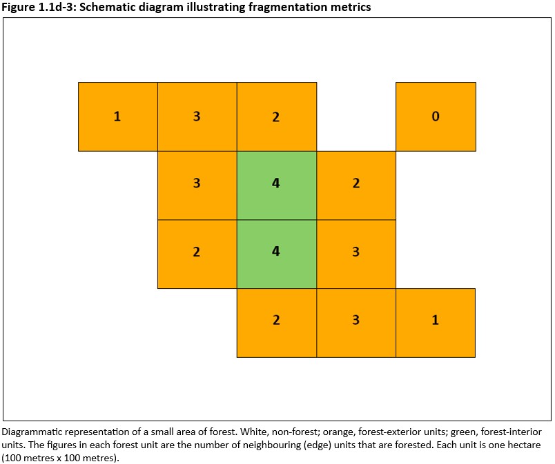
The area represented in Figure 1.1d-3 comprises two patches of forest. The top-right unit is a patch containing one hectare of forest, not being edge-connected to any other forest unit, while the remaining forest units are all edge-connected and make up a 12-hectare patch of forest.

The 13 units in this area of forest comprise 11 forest-exterior units (coloured orange) and 2 forest-interior units (coloured green and containing the number ‘4’): the latter are the units that have all four of their neighbouring (edge) units as forest. In this area of forest, the proportion of forest-interior units is 2 of 13 units = 15%.

The non-forest adjacent to forest-exterior units may be land cleared for agricultural land use, urban development or infrastructure, with potential to affect the forest ecosystem; may be commercial plantation or other forest; may be woody non-forest vegetation such as sparse woodland with under 20% crown cover, and representing a natural vegetation transition with a lesser impact on the native forest area; or may be other non-forest vegetation.

Further information

Click here for Key information on Indicator 1.1d: Fragmentation of forest cover (2025), including:

  • Key points
  • National forest fragmentation statistics
  • Forest fragmentation by crown cover
  • Forest patch size
  • Forest fragmentation impacts to threatened species and ecological communities
  • References

Downloads

  • Indicator 1.1d: Fragmentation of forest cover (2025) PDF [1.0 MB]
  • Tabular data for Indicator 1.1d - Microsoft Excel workbook [0.1 MB]

This publication (and any material sourced from it) should be attributed as: Montreal Process Implementation Group for Australia (MIG) and National Forest Inventory Steering Committee (NFISC) 2025, Indicator 1.1d: Fragmentation of forest cover, Australia’s State of the Forests Report, Australian Bureau of Agricultural and Resource Economics and Sciences, Canberra, December. CC BY 4.0.

Downloadable version of Indicator 1.1d: Fragmentation of forest cover

Context

Forest fragmentation describes natural and human-induced breaks in forest cover such that large, continuous forest patches are separated into smaller, sometimes isolated, patches. Fragmentation creates breaks in ecological connectivity, increases edge effects, and can compromise biodiversity and ecosystem resilience. The fragmentation analysis conducted for this indicator was performed at a broad national scale.

Definitions

Fragmentation:

  1. The degree to which forest exists in separate areas that are not spatially connected.
  2. The process of loss of spatial connectivity between forest areas.

Connectivity: The degree of vegetation structural links between forest patches in a landscape. Connectivity facilitates species movement across a continuous forested landscape, and is the converse of fragmentation.

Forest interior: One-hectare units of native forest with all four edge-neighbouring units of native forest

Forest exterior: One-hectare units of native forest that have one or more edge-neighbouring units of non-native forest or non-forest.

See Australia’s forests and forestry glossary for full definitions and definitions of other terms.

Thanks for your feedback.
Thanks! Your feedback has been submitted.

We aren't able to respond to your individual comments or questions.
To contact us directly phone us or submit an online inquiry

CAPTCHA
This question is for testing whether or not you are a human visitor and to prevent automated spam submissions.

Please verify that you are not a robot.

Skip
Page last updated: 05 December 2025

We acknowledge the continuous connection of First Nations Traditional Owners and Custodians to the lands, seas and waters of Australia. We recognise their care for and cultivation of Country. We pay respect to Elders past and present, and recognise their knowledge and contribution to the productivity, innovation and sustainability of Australia’s agriculture, fisheries and forestry industries.

Artwork: Protecting our Country, Growing our Future
© Amy Allerton, contemporary Aboriginal Artist of the Gumbaynggirr, Bundjalung and Gamilaroi nations.

Footer

  • Contact us
  • Accessibility
  • Disclaimer
  • Privacy
  • FOI

© Department of Agriculture, Fisheries and Forestry

Facebook X LinkedIn Instagram