Key issues
- During the week ending 2 June 2021, a blocking high pressure system resulted in little to no rainfall across eastern and central Australia. However, low pressure troughs and cold fronts brought moderate to heavy rainfall to south-western Australia.
- The rainfall across Western Australian cropping regions has provided a welcome top up to soil moisture levels as winter crop sowing draws to a close. Cropping regions in western Victoria and South Australia are still awaiting substantial rainfall to assist with winter crop establishment.
- Nationally, autumn 2021 rainfall was slightly below average, with the weakening La Niña and the Madden–Julian Oscillation (MJO) influencing Australia’s climate for parts of the season.
- Autumn 2021 rainfall was above average to extremely high across most cropping regions in New South Wales, southern Queensland and Western Australia. Extremely low to below average rainfall was recorded in cropping regions across parts of south-western New South Wales and much of Victoria and South Australia. In those cropping regions that recorded substantial rainfall in March and May this has largely negated below average rainfall in April and has benefitted the establishment of winter crops.
- Over the next eight days, troughs and complex frontal systems are likely to bring showers and storms to large areas of eastern Australia and parts of Western Australia. High-pressure systems are expected to keep rainfall totals low for the majority of central and northern Australia during the 8 days to 10 June 2021.
- In Australia’s cropping regions, rainfall totals of between 10 and 50 millimetres are forecast for New South Wales, Victoria, southern Queensland, much of South Australia and the far west of Western Australia. If realised, the rainfall forecast across many Victorian and South Australian cropping regions will consolidate opening season rainfall totals recorded on 25 and 26 May 2021 and provide a welcome top up to soil moisture levels and assist with the germination and establishment of dry sown crops.
- Water storage in the Murray–Darling Basin (MDB) increased by 101 gigalitres (GL) between 25 May 2021 and 2 June 2021. The current volume of water held in storage is 14,758 GL, which represents 58% of total capacity. This is 45% or 4,607 GL more than at the same time last year.
- Allocation prices in the Victorian Murray below the Barmah Choke increased from $93 per ML on 21 May 2021 to $94 per ML on 28 May 2021. Trade is open from the Murrumbidgee, with prices increasing during the week.
Climate
[expand all]
Rainfall this week
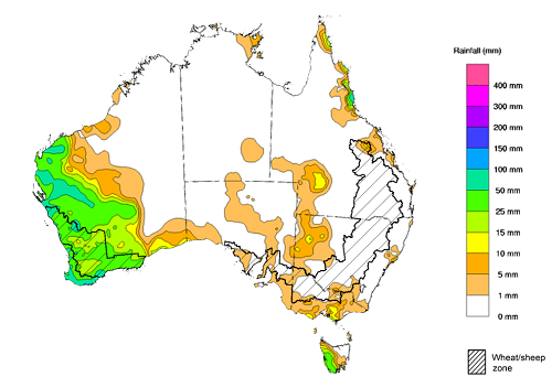
During the week ending 2 June 2021, a blocking high pressure system resulted in little to no rainfall across eastern and central Australia. However, low pressure troughs and cold fronts brought moderate to heavy rainfall to south-western Australia.
Rainfall totals of between 5 and 25 millimetres were recorded across isolated parts of New South Wales, Queensland, Victoria, South Australia and the Northern Territory. Rainfall totals in excess of 25 millimetres were recorded across isolated parts of north-eastern Queensland, much of the south and west of Western Australia and western Tasmania.
In cropping regions, rainfall totals of between 15 and 50 millimetres was recorded across Western Australian cropping regions. Little to no rainfall was recorded across most cropping regions in New South Wales, Victoria, Queensland and South Australia during the week ending 2 June 2021.
The rainfall across Western Australian cropping regions has provided a welcome top up to soil moisture levels as winter crop sowing draws to a close. The dry conditions in eastern cropping regions have allowed sowing to continue uninterrupted, with good soil moisture levels from previous falls. Cropping regions in western Victoria and South Australia are still awaiting substantial rainfall to assist with winter crop establishment.
Rainfall for the week ending 2 June 2021
©Commonwealth of Australia 2021, Australian Bureau of Meteorology - Issued: 02/06/2021
Note: The rainfall analyses and associated maps utilise data contained in the Bureau of Meteorology climate database, the Australian Data Archive for Meteorology (ADAM). The analyses are initially produced automatically from real-time data with limited quality control. They are intended to provide a general overview of rainfall across Australia as quickly as possible after the observations are received. For further information go to http://www.bom.gov.au/climate/rainfall/
Monthly temperatures
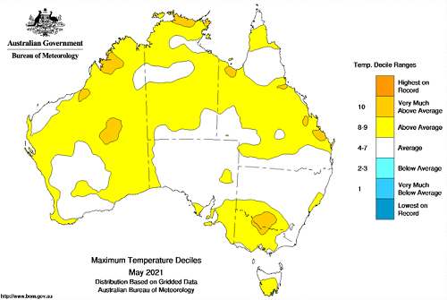
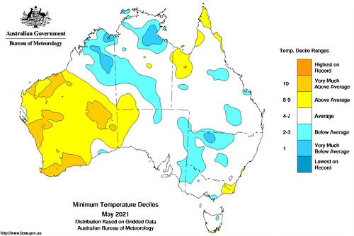
May 2021 was warmer than average nationally with a national mean temperature of 0.51°C above average, a mean maximum temperature of 1.04°C above average and a mean minimum temperature of 0.03°C below average.
Maximum temperatures for May were above average to very much above average across large parts of western and northern Australia and parts of south-eastern Australia. Minimum temperatures were above average to very much above average across much of Western Australia and isolated parts of north-eastern and south-eastern Australia. Minimum temperatures were below average to very much below average across parts of northern, central and eastern Australia. Across cropping regions in Western Australia above average temperatures coupled with above average rainfall and soil moisture levels, are likely to have resulted in rapid development of early sown winter crops and increased the growth rate of pastures.
Maximum temperature deciles for May 2021
©Commonwealth of Australia 2021, Australian Bureau of Meteorology - Issued: 01/06/2021
Minimum temperature deciles for May 2021
©Commonwealth of Australia 2021, Australian Bureau of Meteorology - Issued: 01/06/2021
Note: Maximum and minimum temperatures for May 2021 compared with temperature recorded for that period during the historical record (1900 to present). For further information go to http://www.bom.gov.au/water.
Monthly rainfall
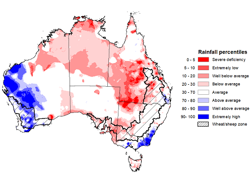
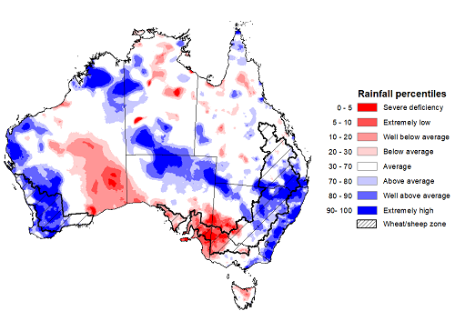
Rainfall during May 2021 was below average for much of Australia. Rainfall was extremely low to well below average across much of central and southern Queensland and parts of western New South Wales, north-western Victoria, the south of South Australia, northern Western Australia and the Northern Territory. In contrast, May 2021 rainfall was well above average to extremely high across parts of south-eastern New South Wales, southern Victoria and the west of Western Australia.
The El Niño–Southern Oscillation (ENSO) and the Indian Ocean Dipole (IOD) were neutral during May and the Southern Annular Mode (SAM) has little influence on Australia’s climate during autumn. May rainfall was largely influenced by local climate systems and ocean temperatures surrounding Australia. Little or no rainfall is typically recorded across much of northern Australia during May as it is the start of the northern dry season. Cold fronts and troughs generated moderate rainfall across the west of Western Australia and parts of south-eastern Australia during May.
May rainfall was severely deficient to below average across cropping regions in south-western New South Wales, western Queensland, Victoria and South Australia. Rainfall was above average to extremely high across central Western Australia cropping regions and generally average across remaining cropping regions in New South Wales, eastern Queensland and Western Australia.
Rainfall across cropping regions benefitted the establishment and growth of early sown winter crops and encouraged additional planting activity. Further rainfall is needed to support crop growth and benefit yields, particularly across South Australia and parts of Victoria where rainfall totals and soil moisture levels have been low.
Rainfall percentiles for May 2021
Note: Rainfall for May 2021 is compared with rainfall recorded for that period during the historical record (1900 to present). For further information, go to http://www.bom.gov.au/water/
Source: Bureau of Meteorology
Seasonal rainfall
Autumn 2021 rainfall was slightly below average nationally, with the weakening La Niña and the Madden–Julian Oscillation (MJO) influencing Australia’s climate for parts of the season. Autumn 2021 rainfall was above average to extremely high across most winter cropping regions in New South Wales, southern Queensland and Western Australia. Extremely low to below average rainfall was recorded in cropping regions across parts of south-western New South Wales and much of Victoria and South Australia.
The season began with above average or better rainfall across most cropping regions in New South Wales, Queensland, eastern Victoria and Western Australia. Generally average rainfall was recorded across cropping remaining cropping regions. ABARES analysis indicated that an early autumn break had been achieved across most cropping regions in New South Wales, Western Australia and parts of southern Queensland, central Victoria and Tasmania due to the heavy rainfall in mid- to late-March. The heavy rainfall across northern New South Wales and southern Queensland led to harvest delays and some grain quality downgrades and sprouting in the summer crops nearing harvest. However, these falls improved prospects for some late-sown summer crops and substantially improved soil moisture levels for the sowing of winter crops.
During April the El Niño–Southern Oscillation (ENSO) was neutral and the influence of the recent La Niña event on Australia’s climate diminished. April rainfall was severely deficient to below average for most of the cropping regions in central and southern New South Wales, Victoria and South Australia. Rainfall was above average to extremely high for most cropping regions in Western Australia and generally average across cropping regions in northern New South Wales and Queensland. The early autumn break in March was not consolidated during April for large areas of New South Wales and Victoria.
Average or better May rainfall across cropping regions in parts of eastern and Western Australia benefitted the establishment and growth of early sown winter crops and encouraged additional planting activity. Cropping regions in large parts of Queensland, Victoria and much of South Australia that received low May rainfall and have low soil moisture will need further rainfall to support crop growth and benefit yields.
Rainfall percentiles for autumn 2021 (1 March to 31 May 2021)
Note: Rainfall for March 2021 to May 2021 is compared with rainfall recorded for that period during the historical record (1900 to present). For further information, go to http://www.bom.gov.au/water/
Source: Bureau of Meteorology
Monthly soil moisture
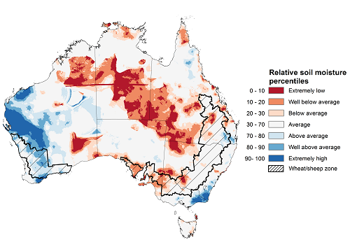
Upper layer soil moisture in May 2021 was extremely low to below average for this time of year across parts of northern, central, eastern and far southern Australia, reflecting rainfall patterns during the month. However, modelled upper layer soil moisture was above average to extremely high across large parts of Western Australia and isolated parts of eastern Australia. Upper layer soil moisture is important at the beginning of the winter cropping season since plant germination and establishment utilise this moisture.
Upper layer soil moisture was extremely low to below average for this time of year across most cropping regions in South Australia and parts of western Queensland, south-western New South Wales and western Victoria. Soil moisture was above average to well above average across most cropping regions in Western Australia and average across remaining cropping regions in New South Wales, Queensland and Victoria.
Modelled upper layer soil moisture for May 2021
Note: This map shows the levels of modelled upper layer soil moisture (0 to 10 centimetres) during May 2021. This map shows how modelled soil conditions during May 2021 compare with May conditions modelled over the reference period (1911 to 2016). Dark blue areas on the maps were much wetter in May 2021 than during the reference period. The dark red areas were much drier than during the reference period. The bulk of plant roots occur in the top 20 centimetres of the soil profile. Soil moisture in the upper layer of the soil profile is therefore useful indicator of the availability of water, particularly for germinating seed.
Source: Bureau of Meteorology (Australian Water Resources Assessment Landscape model)
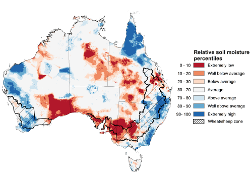
Lower layer soil moisture for May 2021 was above average to extremely high for this time of year across parts of western and eastern Australia, and parts of northern Australia. Lower layer soil moisture was extremely low to below average across parts of central and southern Australia, north-western and south-eastern Western Australia and inland areas of eastern Australia.
In cropping regions, lower layer soil moisture was above average to extremely high for parts of central and northern New South Wales, southern Queensland and central Western Australia. Lower layer soil moisture was extremely low to below average in cropping regions across parts of southern New South Wales and northern Queensland, and across much of Victoria and South Australia.
Modelled lower layer soil moisture for May 2021
Note: This map shows the levels of modelled lower layer soil moisture (10 to 100 centimetres) during May 2021. This map shows how modelled soil conditions during May 2021 compare with May conditions modelled over the reference period (1911 to 2016). Dark blue areas on the maps were much wetter in May 2021 than during the reference period. The dark red areas were much drier than during the reference period. The bulk of plant roots occur in the top 20 centimetres of the soil profile. The lower layer soil moisture is a larger, deeper store that is slower to respond to rainfall and tends to reflect accumulated rainfall events over longer time periods.
Source: Bureau of Meteorology (Australian Water Resources Assessment Landscape model)
Rainfall forecast for the next eight days
Troughs and complex frontal systems are likely to bring showers and storms to large areas of eastern Australia and parts of Western Australia during the 8 days to 10 June 2021. High-pressure systems are expected to keep rainfall totals low for the majority of central and northern Australia during the next 8 days.
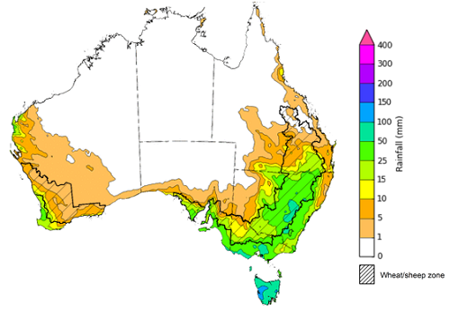
Rainfall totals of between 5 and 50 millimetres are forecast for much of New South Wales, Victoria, and Tasmania, and across parts of north-eastern and southern Queensland, southern South Australia, and the west of Western Australia.
In Australia’s cropping regions, rainfall totals of between 10 and 50 millimetres are forecast for New South Wales, Victoria, southern Queensland, much of South Australia and the far west of Western Australia. Rainfall totals of between 1 and 10 millimetres is expected across remaining cropping regions in Queensland, South Australia and Western Australia.
If realised, the rainfall forecast across many Victorian and South Australian cropping regions will consolidate opening season rainfall totals recorded on 25 and 26 May 2021 and provide a welcome top up to soil moisture levels and assisting with the germination and establishment of dry sown crops. The falls forecast across New South Wales and southern Queensland will likely benefit the establishment and growth of early sown winter crops and allow farmers to finalise planting programs.
The dry forecast for the next 8 days across cropping regions in Western Australia will allow for the finalisation of planting programs and the application of fertilizer and post-emergent weed control following this week’s rain and facilitate the drying of some waterlogging in southern growing regions.
Total forecast rainfall (mm) for the period 3 June to 10 June 2021
©Commonwealth of Australia 2021, Australian Bureau of Meteorology - Issued: 03/06/2021
Note: This rainfall forecast is produced from computer models. As the model outputs are not altered by weather forecasters, it is important to check local forecasts and warnings issued by the Bureau of Meteorology.
Water
Water storages, water markets and water allocations - current week
The Tableau dashboard may not meet accessibility requirements. For information about the contents of these dashboards contact ABARES.
Commodities
Information on weekly price changes in agricultural commodities is now available at the Weekly commodity price update.

