
Key issues
- In the week ending 13 March 2024, the Top End and northern and the interior of Western Australia received significant rainfall, and decent rainfall was experienced along the coastal east and tropical areas of Queensland.
- A lack of rainfall in most cropping areas, coupled with elevated temperatures, particularly in southern areas, is likely to have led to a reduction in soil moisture levels, particularly in the upper soil profile.
- Over the coming days, the tropics and the interior of Western Australia will continue to receive rainfall, and eastern Queensland and New South Wales are expected to experience showers and storms.
- A dry week in Queensland and northern New South Wales cropping regions will support uninterrupted harvest of summer crops.
- Rainfall totals up to 50 millimetres are forecast for central New South Wales and Western Australia cropping regions.
- The national rainfall outlook is for a heightened probability of below average rainfall for much of Australia over the next three months.
- Considering the recent declines in upper layer soil moisture levels, sufficient and timely rainfall will be required in the coming months in order to facilitate the sowing and establishment of winter crops.
- Availability of accumulated standing dry matter and ample conserved fodder is likely to enable most livestock producers to maintain current production levels and stocking rates.
- Water storage levels in the Murray-Darling Basin (MDB) decreased between 7 March 2024 and 14 March 2024 by 190 gigalitres (GL). Current volume of water held in storage is 17 553 GL, equivalent to 78% of total storage capacity. This is 13 percent or 2536 GL less than at the same time last year.
- Allocation prices in the Victorian Murray below the Barmah Choke increased from $26 on 7 March 2024 to $27 on 14 March 2024. Prices are lower in the Murrumbidgee due to the binding of the Murrumbidgee export limit.
Climate
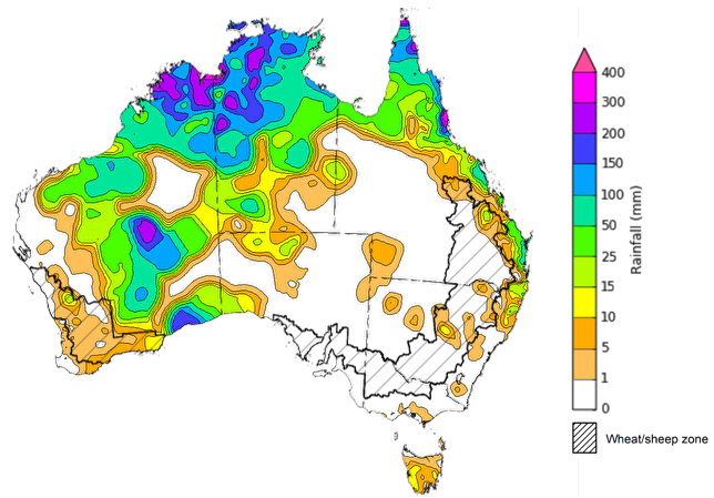
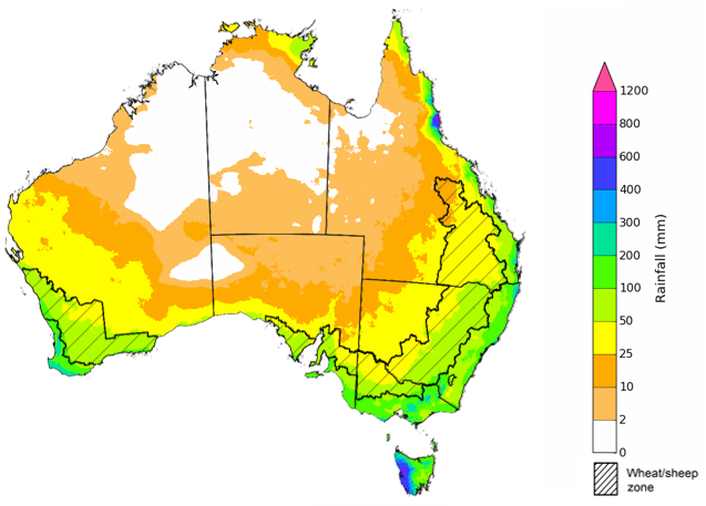
For the week ending 13 March 2024, the monsoon trough spanning the Top End and northern Western Australia resulted in significant rainfall, ranging from 100 to 300 millimetres. Additionally, a cold front triggered rainfall in the interior and southern regions of Western Australia, while onshore winds facilitated rainfall along the coastal east and tropical areas of Queensland.
Within cropping regions, rainfall totals reached up to 25 millimetres in the northern reaches of Western Australia and Queensland, with isolated areas of southern Western Australia and central New South Wales receiving up to 15 millimetres. A lack of rainfall in most cropping areas, coupled with elevated temperatures, particularly in southern areas, is likely to have led to a reduction in soil moisture levels, particularly in the upper soil profile.
Dry conditions prevailing in Queensland and northern New South Wales likely facilitated an uninterrupted harvest of summer crops with notably high yields in sorghum.
Rainfall for the week ending 13 March 2024
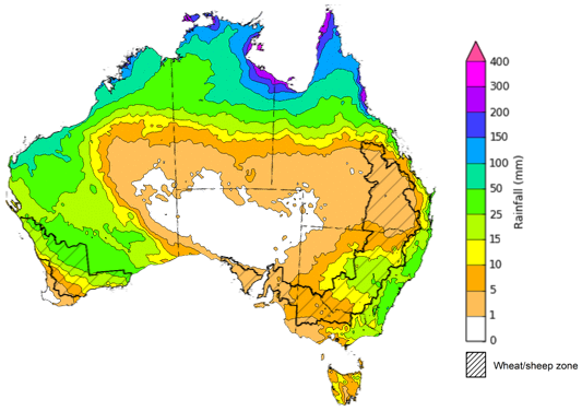
Over the 8 days to 21 March 2024, monsoon lows will generate rain and storms in the tropics extending to the interior of Western Australia with anticipated accumulations of up to 200 millimetres. Humid and unstable atmospheric conditions are expected to generate showers and storms across areas of eastern Queensland and New South Wales.
Across cropping regions, rainfall totals up to 50 millimetres are forecast for central New South Wales. If realised, these falls will boost soil moisture levels for pasture growth. With the harvest of early planted summer crop now underway, mainly dry conditions over the next 8-days would support an uninterrupted harvest in Queensland and northern New South Wales.
Large areas of Western Australia are expected to receive up to 50 millimetres of rainfall. If realised, these falls will continue to build soil moisture levels ahead of the upcoming winter cropping season. However, timely falls will be required closer to planting of winter crops to consolidate this recent boost in soil moisture.
Little to no rainfall is expected across remaining cropping regions.
Total forecast rainfall for the period 14 March to 21 March 2024
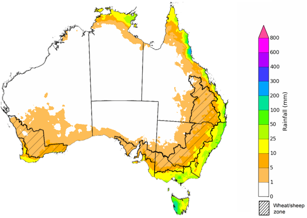
The most recent rainfall outlook for April 2024 provided by the Bureau of Meteorology indicates a high likelihood (60 to 80% chance) of below-median rainfall across a significant portion of Australia. Notable exceptions being Tasmania, along with much of New South Wales and southern areas of Queensland, which are showing an equal probability of below or above median rainfall.
According to Bureau of Meteorology’s climate model, there is a 75% probability of rainfall totals exceeding 25 millimetres in coastal eastern and northern Australia, as well as in western Tasmania and southern Victoria, for April 2024. Northeastern coastal Queensland and western Tasmania are anticipated to receive rainfall totals surpassing 100 millimetres.
Within cropping regions, there is at least 75% chance of rainfall totals exceeding 25 millimetres along the eastern fringes of New South Wales and Victoria. By contrast, April rainfall totals for the remaining cropping regions have a 75% chance of exceeding 5-10 millimetres.
A lack of sufficient rainfall in April is likely to result in an increased disconnect between upper- and lower-layer soil moisture, meaning that there would be limited opportunities to plant winter crops under ideal conditions. This may see many grain producers opt to dry sow crops, which presents some production risk outcomes if May rainfall is not sufficient to support germination and establishment, until plant roots are able to tap into stored lower layer soil moisture.
Rainfall totals that have a 75% chance of occurring in April 2024
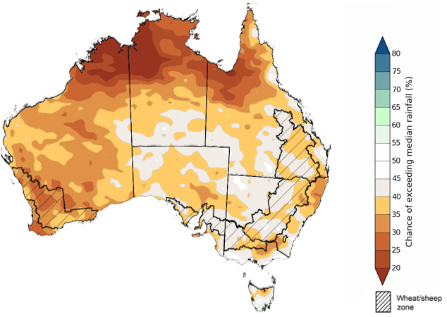
The El Niño event of 2023 persists in its weakening trend, with the anticipation of a transition to neutral ENSO conditions during the current 2024 autumn. The rainfall outlook for April through June 2024 indicates a probability of below-median rainfall across much of Australia.
Across cropping regions, the odds of exceeding median rainfall range between 35 and 45% across most growing regions. The chance of exceeding median rainfall is lower (25 to 40% chance) in Western Australia cropping regions.
Chance of exceeding the median rainfall April to June 2024
The outlook for April to June 2024 suggests there is at least 75% chance of rainfall exceeding 25 millimetres throughout much of southern and eastern Australia, with notable exceptions in large sections of the interior and northern regions where rainfall below 25 millimetres is more likely. Along Australia’s eastern and southern coastline, as well as western Tasmania, rainfall totals in excess of 200 millimetres are expected during this period.
Across cropping regions, there is at least a 75% chance of receiving 25 millimetres or more.
Considering the recent declines in upper layer soil moisture levels and the heightened probability of below average rainfall over the next three months, sufficient and timely rainfall will be required in the coming months in order to facilitate the sowing and establishment of winter crops. Livestock producers, especially those in southern Australia, are expected to experience below-average pasture production due to reduced rainfall. However, the availability of accumulated standing dry matter and ample conserved fodder is likely to enable most producers to maintain current production levels and stocking rates.
Rainfall totals that have a 75% chance of occurring April to June 2024
Water
Water storages, water markets and water allocations - current week
The Tableau dashboard may not meet accessibility requirements. For information about the contents of these dashboards contact ABARES.

Commodities
Information on weekly price changes in agricultural commodities is now available at the Weekly commodity price update.