Skip to main content Skip to main navigation Skip to search
Home

Top navigation main

  • News & media
  • Jobs
  • Ministers
  • Contact us
Main menu

AWE Main

  • Agriculture and land
    Agriculture and land Building stronger and more sustainable agriculture, fisheries, forestry and land care.
    • Animal health
    • Climate change and agriculture
    • Drought, disaster and rural support
    • Farming, food and drought
    • Fisheries
    • Forestry
    • Levies and charges on agricultural products
    • Mouse infestation advice
    • Plant health
    Xylella

    Protect against unwanted plant pests

    Our biosecurity system helps protects us. Everyone has a role in supporting our biosecurity system.

    Find out more

  • Biosecurity and trade
    Biosecurity and trade
    • Aircraft, vessels and military
    • Biosecurity policy
    • Cats and dogs
    • Exporting
    • Importing
    • Pests, diseases and weeds
    • Public awareness and education
    • Trade and market access
    • Travelling or sending goods to Australia
    • Report a concern
    Brown marmorated stink bug

    BMSB Seasonal Measures

    Australia has strengthened seasonal measures to manage the risk of BMSB.

    View our seasonal measures

  • Science and research
    Science and research Undertaking research and collecting data to support informed decisions and policies.
    • Australian Bureau of Agricultural and Resource Economics and Sciences (ABARES)
    • Plant Innovation Centre
    Abares

    ABARES Insights

    Get 'snapshots’ of agricultural, forestry and fisheries industries, or analysis of key issues.

    Find out more

  • About us
    About us We enhance our agricultural industries and trade, and manage the threat of biosecurity risks to Australia.
    • Accountability and reporting
    • Assistance, grants and tenders
    • Contact us
    • Fees and charges
    • News and media
    • Our commitment to you
    • Payments
    • People and jobs
    • Publications
    • What we do
    • Who we are
    Budget 2025-26

    Budget 2025-26

    The 2025–26 Portfolio Budget Statements were released on 25 March 2025.

    Find out more

  • Online services
    Online services We do business with you using online platforms. This makes it easier for you to meet your legal requirements.
Department of Agriculture

Breadcrumb

  1. Home
  2. Agriculture and land
  3. Farming, food and rural support
  4. Natural resources
  5. National Soil Strategy
  6. Ground cover monitoring for Australia

Sidebar first - Farming

  • National Soil Strategy
    • National Soil Action Plan
      • Australian National Soil Information System (ANSIS)
    • National Soil Monitoring Program
    • Soil Science Challenge Grants Program
    • Ground cover monitoring for Australia
    • National Soil RD&E Strategy

Ground cover monitoring for Australia

​November 2012

Supporting the sustainability of our agricultural industries

Ground cover information is critical for land management and the assessment of soil condition in Australia. Recognising the need for a national approach, the Ground Cover Monitoring for Australia project was established in 2009 as a collaborative partnership between the Department of Agriculture, Fisheries and Forestry (DAFF), CSIRO, the Terrestrial Ecosystem Research Network and states and territories. The project is delivering estimates of Australian ground cover at 500 metre resolution from Moderate Resolution Imaging Spectroradiometer (MODIS) satellite data. The project is managed by ABARES.

Accessing the information

From March 2000 MODIS data has been processed using the Guerschman fractional cover method (version 2.2) with field observations used to validate the ground cover estimates. In 2013 extra observations will be used to improve these estimates. Ground cover estimates as raw or summarised MODIS data and field observations can be accessed at remote-sensing.nci.org.au/u39/public/html/. Summaries include mean, maximum, minimum, standard deviations and period of minimum or maximum cover for each fraction. Figure 1 shows example ground cover and associated rainfall data.

Monitoring wind erosion using ground cover estimates from satellite data

Previous studies show that wind erosion is more likely to occur when ground cover is less than 50 per cent. Wind erosion can be monitored through observation of dust. As an example, the Community DustWatch project, funded by Caring for our Country, NSW Office of Environment and Heritage and Natural Resource Management regions, monitors atmospheric dust levels at 40 stations across Australia. Figure 2 shows many paddocks with low ground cover (the red and orange pixels) upwind of stations in north-west Victoria and south-west New South Wales that recorded dust.

Comparing observations of dust with measurements of bare ground for each month and year is also helping the NSW Catchment Management Authorities to determine thresholds for ground cover and set local cover level targets for their Catchment Action Plans.

Monthly maps from the MODIS satellite of areas with more than 50 per cent bare ground are also being used in the national wind erosion model (CEMSYS) see dustwatch.edu.au to identify where erosion may occur across Australia.

Key points

Ground cover is the fraction of living and dry or dead vegetation covering the soil surface, shown as a percentage. Ground not covered by living and dry or dead vegetation is scored as bare ground. Climate and land management affect ground cover levels.

The remote sensing method chosen for this project provides estimates of the area of dry or dead vegetation, which, like living vegetation, protects soil from wind and water erosion. These results give better estimates of the area at risk of wind and water erosion than previously possible.

Quick Fact

Ground cover is one of the recently announced National Sustainability Indicators for Australia. The project described in this fact sheet will provide information on trends in ground cover for the National Sustainability Council’s biennial
public reports against indicators.

Figure 1

Ground cover and rainfall deciles for February and September 2001, 2005 and 2011. Areas with less ground cover (brown) are most at risk of erosion.

maps of australia showing the mean monthly ground cover and annual rainfall deciles.
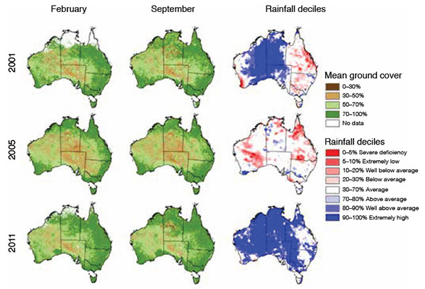
Source: Mean monthly ground cover (ABARES, DAFF); annual rainfall deciles (Bureau of Meteorology).

Figure 2

Hours of dust with average hourly concentration greater than 25 mg/m3 for particle size less than 10 micrometers (figures in parenthesis and size of circles) at each DustWatch station and fractional bare ground cover for February 2012 (colour).

map of New South Wales showing the bare ground cover for February 2012
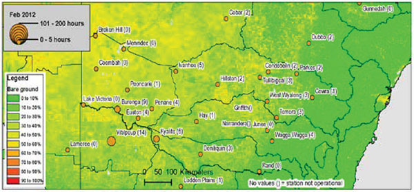
Source: Modified from New South Wales Office of Environment and Heritage DustWatch report February 2012.

General enquiries

Call 1800 900 090

Contact us online

Report a biosecurity concern

Thanks for your feedback.
Thanks! Your feedback has been submitted.

We aren't able to respond to your individual comments or questions.
To contact us directly phone us or submit an online inquiry

CAPTCHA
This question is for testing whether or not you are a human visitor and to prevent automated spam submissions.

Please verify that you are not a robot.

Skip
Page last updated: 04 November 2019

We acknowledge the continuous connection of First Nations Traditional Owners and Custodians to the lands, seas and waters of Australia. We recognise their care for and cultivation of Country. We pay respect to Elders past and present, and recognise their knowledge and contribution to the productivity, innovation and sustainability of Australia’s agriculture, fisheries and forestry industries.

Artwork: Protecting our Country, Growing our Future
© Amy Allerton, contemporary Aboriginal Artist of the Gumbaynggirr, Bundjalung and Gamilaroi nations.

Footer

  • Contact us
  • Accessibility
  • Disclaimer
  • Privacy
  • FOI

© Department of Agriculture, Fisheries and Forestry

Facebook X LinkedIn Instagram