
This section describes the case study region, and provides a brief overview of the methods used to measure the different indicators measured for this report.
2.1 Case study: The Green Triangle
This report presents the results of testing indicators in the Green Triangle region, which covers much of western Victoria and south-east South Australia. This region was chosen to test indicators because it contains a large integrated forest industry.
The Green Triangle region is an important forest industry region in Australia, with the industry predominantly based on plantation forestry. A large area of both hardwood and softwood plantations are located in the region. Softwood plantations have been established in the region since the early 1900s, while hardwood plantations have been established predominantly since the mid-1990s. In 2006, there were more than 170,000 hectares of softwood plantation, and just under 140,000 hectares of hardwood plantation, established in the region1. A significant manufacturing industry has developed over several decades to process the softwood resource. Harvesting of hardwood plantations is currently beginning in the region.
The local government areas (LGAs) included in the Green Triangle study region are shown in Figure 1.
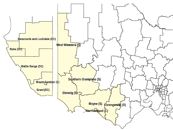
Figure 1: Map of the Green Triangle case study region2
Where possible, indicator data for this case study are presented for different ‘Statistical Local Areas’ in the study region (described below), for ‘Statistical Divisions’ within the region (also described below), and for the states of South Australia and Victoria, and Australia as a whole. This enables comparison of trends in individual LGAs within the region, as well as comparison of the region to state and national averages.
Statistical Local Areas (SLAs) are geographic regions measured by the ABS which are either the same size as, or smaller than, LGAs. Within the study region, each local government area is made up of between one and three SLAs, as shown in Table 1. SLAs are often either equivalent to the boundaries of previous LGAs which were amalgamated, or separate the city and rural areas of an LGA.
|
LGA |
SLA/s in LGA |
Description of SLAs |
|---|---|---|
|
Naracoorte and Lucindale (DC) |
Naracoorte and Lucindale (DC) |
SLA is the same as LGA |
|
Robe (DC) |
Robe (DC) |
SLA is the same as LGA |
|
Wattle Range (DC) |
Wattle Range (DC) – East Wattle Range (DC) - West |
LGA has been split into two SLAs, one covering the east of the SLA (including Penola), the other the West (including Millicent, Tantanoola). |
|
Mount Gambier (C) |
Mount Gambier (C) |
SLA is the same as LGA |
|
Grant (DC) |
Grant (DC) |
SLA is the same as LGA |
|
West Wimmera (S) |
West Wimmera (S) |
SLA is the same as LGA |
|
Southern Grampians (S) |
S. Grampians (S) – Hamilton S. Grampians (S) – Wannon S. Grampians (S) - Bal |
LGA has been split into three SLAs, in which ‘Hamilton’ is equivalent to the city of Hamilton, ‘Wannon’ is in the west of the LGA, and ‘Bal’ (referring to ‘Balance’) covers the east of the LGA |
|
Glenelg (S) |
Glenelg (S) – Heywood Glenelg (S) – North Glenelg (S) – Portland |
LGA has been split into three SLAs, in which ‘Portland’ is equivalent to the city of Portland, ‘Heywood’ is in the southern half of the LGA, and ‘North’ covers the northern part of the LGA |
|
Moyne (S) |
Moyne (S) - North-East Moyne (S) - North-West Moyne (S) - South |
LGA has been split into three SLAs, each of which covers the geographic part of the LGA as described (north-east, north-west and south). |
|
Warrnambool (C) |
Warrnambool (C) |
SLA is the same as LGA |
|
Corangamite (S) |
Corangamite (S) – North Corangamite (S) – South |
LGA has been split into two SLAs, each of which covers the geographic part of the LGA as described (north and south). |
Statistical Divisions (SDs) refer to groupings of LGAs which are considered to have some geographic and economic linkages that mean they form a coherent group. In the case study region, there are three SDs:
- South East (SA): The South East SD consists of the LGAs of Grant, Mount Gambier, Wattle Range, Naracoorte and Lucindale, and Robe;
- Western District (Vic): The Western District SD consists of the LGAs of Warrnambool, Corangamite, Moyne, Glenelg, and Southern Grampians; and
- Wimmera (Vic). This SD includes the LGA of West Wimmera. As it includes only a single LGA, it is usually presented together with the Western District SD.
For some indicators, it was not possible to gather data to the LGA scale, with only larger scale data available. This is identified as each indicator is presented and discussed.
2.2 Methods
The data sources and methods used to measure each indicator are explained briefly as each is presented in Section 3.0. A more detailed discussion of the methods used to calculate each indicator can be found in Schirmer et al. (2008a).
This section describes the types of data used to measure indicators, with all indicators presented in this report measured using one of two types of data:
- Data from existing sources such as the Australian Bureau of Statistics (ABS); or
- Data from a small survey of Australian forestry workers undertaken for this consultancy.
2.2.1 Data from existing sources
Where data from existing sources have been used to calculate indicators, the data source and methods used are briefly described when the indicator is reported. More detailed information on the methods used to calculate each indicator can be found in the methods used to calculate each indicator can be found in Schirmer et al. (2008a).
2.2.2 Data from survey of forestry workers
Some indicators could not be measured using existing data as no data are currently available for them. Where this was the case, data were gathered via an online survey which was sent to forestry companies operating in the case study regions examined for this consultancy3.
The survey included a range of questions on forest workers’ health, wellbeing, and attachment to place and to the forestry industry, including:
- Health – the types and severity of health problems experienced;
- Workplace health risks – a rating of the extent to which the work the respondent undertakes is believed to present a health risk (e.g. hours worked, stress, exposure to noise, exposure to physical risk);
- Satisfaction with different aspects of life (family, finance, overall level of satisfaction);
- Satisfaction with different aspects of work in the forest industry (e.g. the amount of challenge their work presents);
- Level of attachment to the local community the respondents lives in; and
- Level of cultural and family attachment to forestry.
Valid survey responses were received from 132 respondents. Of these, 54 were based in Tasmania, 19 in the Green Triangle, and 56 in other regions. This means the responses from the Green Triangle can be compared to responses from workers in the other regions included in the survey4.
Responses to the survey are likely to have been biased. Respondents were predominantly involved in managing plantations and native forests, with a smaller proportion involved in silvicultural activities, and very few employed in processing. The responses are therefore biased towards those involved in forest management and administrative positions, and away from field-based workers and workers in manufacturing jobs (Figure 2).
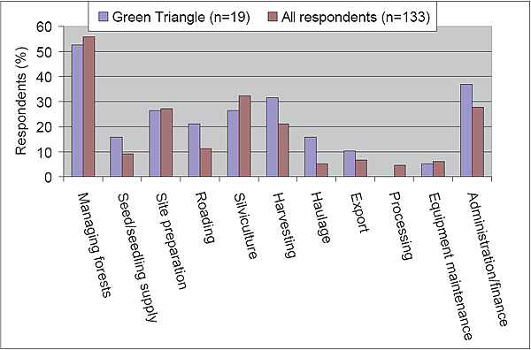
Figure 2: Occupation of forestry workers responding to survey
General characteristics of respondents were as follows:
- Gender: 70% male; 30% female for both Green Triangle and respondents overall;
- Average age: 37 years for Green Triangle respondents and 39 years for all respondents;
- Average length of time working in the industry: 11.4 years for Green Triangle respondents, and 13.3 years for all respondents; and
- Respondents worked in all sectors of the forest industry, although a greater percentage worked in plantation forestry.
While the survey was reasonably small, the responses received enable testing of some key recommended indicators; the results are discussed as individual indicators are reported. They should be considered biased towards people working in particular jobs in the industry, and not representative of all types of forest industry workers.
1 These data are based on the Bureau of Rural Sciences National Plantation Inventory database.
2 Local government areas included in the study are shown in yellow. The letters in brackets after each name refer to the type of local government, where ‘DC’ refers to ‘District Council’, ‘S’ refers to ‘Shire’, and ‘C’ refers to ‘City’.
3 Ethics approval was gained from the Australian National University Human Research Ethics Committee (‘the Committee’) prior to the release of the survey.
4 Many forestry businesses operate across multiple regions; while the survey was sent principally to those operating in the Green Triangle and Tasmania – the regions examined for this consultancy – companies were encouraged to send the survey to all their workers so responses from these regions could be compared to the broader sample of forestry workers achieved.