
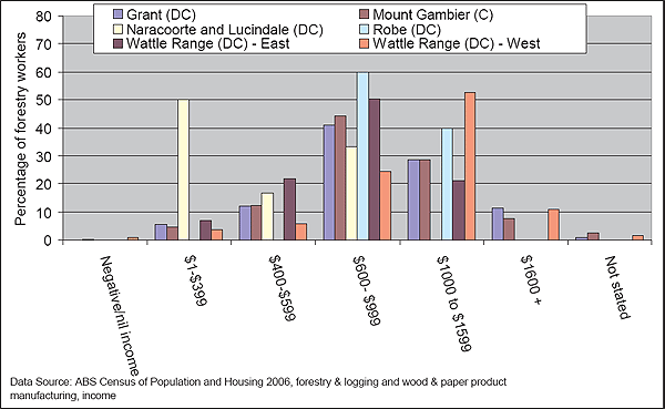
Figure A3.1: Distribution of forestry worker income, 2006 – local areas in South East South Australia
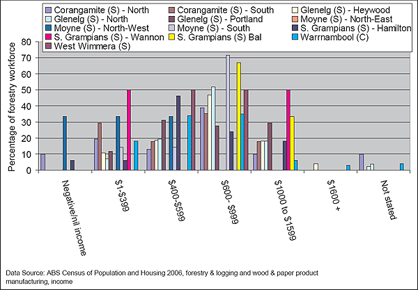
Figure A3.2: Distribution of forestry worker income, 2006 – local areas in the Western District and Wimmera regions of Victoria
A3.2 Age distribution
|
|
Forest industry 15-24 years |
Total labour force 15-24 years |
Forest industry 25-34 years |
Total labour force 25-34 years |
Forest industry 35-44 years |
Total labour force 35-44 years |
Forest industry 45-54 years |
Total labour force 45-54 years |
Forest industry 55-64 years |
Total labour force 55-64 years |
Forest industry 65 years and older |
Total labour force 65 years and older |
|---|---|---|---|---|---|---|---|---|---|---|---|---|
|
Australia |
13.9% |
16.7% |
22.3% |
21.4% |
27.1% |
24.0% |
23.1% |
22.8% |
11.8% |
12.7% |
1.7% |
2.4% |
|
South Australia |
13.5% |
16.6% |
22.4% |
19.8% |
28.9% |
23.9% |
22.8% |
24.0% |
11.1% |
13.4% |
1.2% |
2.3% |
|
Victoria |
12.1% |
16.0% |
23.1% |
22.1% |
27.6% |
24.4% |
23.6% |
22.7% |
11.7% |
12.4% |
1.9% |
2.4% |
|
South East (SA) |
12.5% |
15.5% |
19.7% |
18.4% |
28.7% |
24.7% |
25.2% |
24.2% |
12.4% |
13.8% |
1.7% |
3.4% |
|
Western District (Vic) |
14.9% |
15.3% |
23.7% |
17.1% |
27.6% |
23.7% |
20.8% |
25.0% |
10.5% |
14.6% |
2.5% |
4.2% |
|
Wimmera (Vic) |
9.2% |
13.3% |
21.1% |
15.9% |
31.7% |
23.7% |
26.0% |
25.8% |
11.3% |
15.7% |
0.8% |
5.6% |
|
Grant (DC) |
0.0% |
13.2% |
30.0% |
15.0% |
35.0% |
27.0% |
35.0% |
25.6% |
0.0% |
14.9% |
0.0% |
4.2% |
|
Mount Gambier (C) |
8.0% |
18.5% |
22.0% |
20.6% |
24.7% |
23.7% |
24.0% |
23.1% |
17.3% |
12.0% |
4.0% |
2.1% |
|
Naracoorte and Lucindale (DC) |
9.4% |
15.9% |
15.3% |
17.7% |
40.0% |
23.9% |
25.9% |
25.3% |
9.4% |
13.9% |
0.0% |
3.3% |
|
Robe (DC) |
24.5% |
12.6% |
11.3% |
15.7% |
26.4% |
24.2% |
20.8% |
21.4% |
11.3% |
17.8% |
5.7% |
8.4% |
|
Wattle Range (DC) - East |
21.3% |
11.8% |
21.3% |
22.0% |
21.3% |
26.0% |
23.4% |
21.3% |
12.8% |
15.5% |
0.0% |
3.5% |
|
Wattle Range (DC) - West |
50.0% |
13.1% |
50.0% |
16.3% |
0.0% |
26.4% |
0.0% |
26.0% |
0.0% |
14.4% |
0.0% |
3.8% |
|
Corangamite (S) - North |
19.0% |
12.1% |
20.3% |
16.5% |
23.6% |
24.0% |
22.9% |
25.3% |
12.5% |
17.0% |
1.7% |
5.0% |
|
Corangamite (S) - South |
34.7% |
12.2% |
23.6% |
16.2% |
13.9% |
26.3% |
15.3% |
25.3% |
12.5% |
14.9% |
0.0% |
5.1% |
|
Glenelg (S) - Heywood |
16.7% |
11.6% |
33.3% |
14.2% |
16.7% |
24.7% |
0.0% |
27.4% |
33.3% |
16.7% |
0.0% |
5.4% |
|
Glenelg (S) - North |
33.3% |
11.3% |
33.3% |
12.4% |
0.0% |
24.7% |
33.3% |
26.1% |
0.0% |
18.3% |
0.0% |
7.1% |
|
Glenelg (S) - Portland |
5.8% |
15.7% |
16.3% |
19.2% |
37.3% |
25.3% |
26.6% |
25.6% |
12.8% |
12.0% |
1.3% |
2.3% |
|
Moyne (S) - North-East |
11.4% |
10.0% |
23.9% |
15.1% |
30.1% |
20.9% |
25.0% |
29.7% |
8.8% |
15.9% |
0.8% |
8.5% |
|
Moyne (S) - North-West |
8.8% |
10.8% |
27.1% |
13.0% |
30.0% |
25.0% |
24.1% |
24.2% |
10.0% |
18.7% |
0.0% |
8.3% |
|
%Moyne (S) - South |
6.1% |
13.5% |
15.2% |
16.1% |
33.1% |
23.7% |
29.0% |
25.8% |
16.1% |
15.8% |
0.5% |
5.1% |
|
S. Grampians (S) - Hamilton |
38.6% |
17.9% |
20.8% |
18.5% |
11.9% |
20.9% |
18.8% |
24.0% |
9.9% |
15.5% |
0.0% |
3.1% |
|
S. Grampians (S) - Wannon |
20.7% |
12.3% |
20.7% |
11.9% |
17.2% |
22.4% |
31.0% |
27.5% |
10.3% |
17.1% |
0.0% |
8.7% |
|
S. Grampians (S) Bal |
28.6% |
9.7% |
28.6% |
13.7% |
14.3% |
22.7% |
14.3% |
27.0% |
14.3% |
19.4% |
0.0% |
7.5% |
|
Warrnambool (C) |
|
20.0% |
|
19.7% |
|
23.2% |
|
23.3% |
|
11.7% |
|
2.1% |
|
West Wimmera (S) |
33.3% |
10.2% |
33.3% |
12.8% |
0.0% |
24.7% |
0.0% |
24.8% |
33.3% |
18.2% |
0.0% |
9.3% |
|
Data source: ABS Census of Population and Housing 2006. |
||||||||||||
A3.3 Gender
|
|
2006 |
2001 |
||||||
|---|---|---|---|---|---|---|---|---|
|
|
Males - forest industry |
Males - labour force |
Females - forest industry |
Females - labour force |
Males - forest industry |
Males - labour force |
Females - forest industry |
Females - labour force |
|
Australia |
82.5% |
53.9% |
17.5% |
46.1% |
83.2% |
55.1% |
16.8% |
44.9% |
|
South Australia |
82.6% |
53.7% |
17.4% |
46.3% |
83.3% |
55.2% |
16.7% |
44.8% |
|
Victoria |
82.1% |
53.8% |
17.9% |
46.2% |
83.2% |
54.9% |
16.8% |
45.1% |
|
South East (SA) |
82.9% |
55.9% |
17.1% |
44.1% |
83.6% |
57.4% |
16.4% |
42.6% |
|
Western District (Vic) |
81.9% |
54.9% |
18.1% |
45.1% |
84.9% |
56.4% |
15.1% |
43.6% |
|
Wimmera (Vic) |
85.1% |
55.5% |
14.9% |
44.5% |
79.3% |
57.2% |
20.7% |
42.8% |
|
Grant (DC) |
79.3% |
56.0% |
20.7% |
44.0% |
80.1% |
56.8% |
19.9% |
43.2% |
|
Mount Gambier (C) |
84.5% |
54.5% |
15.5% |
45.5% |
84.4% |
56.3% |
15.6% |
43.7% |
|
Naracoorte and Lucindale (DC) |
76.9% |
56.3% |
23.1% |
43.7% |
80.6% |
57.6% |
22.6% |
42.4% |
|
Robe (DC) |
100.0% |
53.1% |
0.0% |
46.9% |
62.5% |
57.3% |
0.0% |
42.7% |
|
Wattle Range (DC) - East |
69.9% |
57.0% |
30.1% |
43.0% |
73.5% |
57.6% |
26.5% |
42.4% |
|
Wattle Range (DC) - West |
86.4% |
56.6% |
13.6% |
43.4% |
87.4% |
58.8% |
12.6% |
41.2% |
|
Corangamite (S) - South |
80.0% |
57.1% |
20.0% |
42.9% |
100.0% |
57.0% |
0.0% |
43.0% |
|
Corangamite (S) - North |
89.3% |
55.3% |
10.7% |
44.7% |
86.4% |
56.2% |
13.6% |
43.8% |
|
Glenelg (S) - Heywood |
85.8% |
56.5% |
14.2% |
43.5% |
83.3% |
57.7% |
16.7% |
42.3% |
|
Glenelg (S) - North |
80.5% |
55.5% |
19.5% |
44.5% |
90.6% |
57.1% |
9.4% |
42.9% |
|
Glenelg (S) - Portland |
73.5% |
55.7% |
26.5% |
44.3% |
81.5% |
57.8% |
20.0% |
42.2% |
|
Moyne (S) - North-East |
|
56.8% |
|
43.2% |
0.0% |
58.4% |
100.0% |
41.6% |
|
Moyne (S) - North-West |
|
56.4% |
|
43.6% |
100.0% |
59.2% |
0.0% |
40.8% |
|
Moyne (S) - South |
77.8% |
54.8% |
22.2% |
45.2% |
95.8% |
56.6% |
16.7% |
43.4% |
|
S. Grampians (S) - Hamilton |
84.1% |
55.1% |
15.9% |
44.9% |
85.2% |
56.5% |
14.8% |
43.5% |
|
S. Grampians (S) - Wannon |
0.0% |
56.8% |
100.0% |
43.2% |
0.0% |
57.9% |
75.0% |
42.1% |
|
S. Grampians (S) Bal |
85.7% |
56.3% |
14.3% |
43.7% |
73.3% |
56.8% |
23.3% |
43.2% |
|
Warrnambool (C) |
90.7% |
52.9% |
9.3% |
47.1% |
88.0% |
54.6% |
13.0% |
45.4% |
|
West Wimmera (S) |
100.0% |
56.8% |
0.0% |
43.2% |
66.7% |
59.3% |
0.0% |
40.7% |
|
Data source: ABS Census of Population and Housing 2001, 2006. |
||||||||
A3.4 Hours worked
|
|
Coranga- mite (S) - North |
Coranga-mite (S) - South |
Glenelg (S) - Heywood |
Glenelg (S) - North |
Glenelg (S) - Portland |
Moyne (S) - North-East |
Moyne (S) - North-West |
Moyne (S) - South |
S. Grampi-ans (S) - Hamilton |
S. Grampi-ans (S) - Wannon |
S. Grampi- ans (S) Bal |
Warrnam-bool (C) |
West Wimmera (S) |
|---|---|---|---|---|---|---|---|---|---|---|---|---|---|
|
Labour force - None |
3.5% |
4.3% |
5.8% |
4.4% |
6.8% |
2.5% |
3.3% |
5.2% |
4.8% |
4.2% |
3.3% |
4.0% |
5.0% |
|
Forestry - None |
0.0% |
0.0% |
3.9% |
3.5% |
0.0% |
|
50.0% |
0.0% |
0.0% |
50.0% |
0.0% |
3.0% |
0.0% |
|
Labour force - 1-15 hours |
12.6% |
11.1% |
11.6% |
11.2% |
12.4% |
10.5% |
11.7% |
13.1% |
12.9% |
11.1% |
10.7% |
13.9% |
9.8% |
|
Forestry - 1-15 hours |
10.7% |
0.0% |
0.0% |
0.0% |
6.0% |
|
50.0% |
0.0% |
6.7% |
0.0% |
0.0% |
3.0% |
0.0% |
|
Labour force - 16-24 hours |
9.1% |
7.1% |
7.9% |
8.9% |
9.6% |
9.6% |
7.0% |
8.8% |
8.8% |
8.8% |
10.0% |
9.5% |
8.2% |
|
Forestry - 16-24 hours |
0.0% |
16.7% |
5.2% |
3.5% |
0.0% |
|
0.0% |
27.3% |
13.3% |
50.0% |
0.0% |
3.0% |
0.0% |
|
Labour force - 25-34 hours |
10.7% |
8.4% |
9.2% |
11.9% |
10.0% |
7.6% |
9.1% |
9.4% |
10.8% |
8.7% |
9.0% |
10.0% |
9.7% |
|
Forestry - 25-34 hours |
10.7% |
0.0% |
1.9% |
17.6% |
0.0% |
|
0.0% |
0.0% |
0.0% |
0.0% |
25.0% |
5.1% |
0.0% |
|
Labour force - 35-39 hours |
10.2% |
8.2% |
13.0% |
10.9% |
15.0% |
9.8% |
8.1% |
11.5% |
16.7% |
7.8% |
10.6% |
17.3% |
7.7% |
|
Forestry - 35-39 hours |
10.7% |
16.7% |
24.7% |
21.2% |
24.0% |
|
0.0% |
13.6% |
6.7% |
0.0% |
0.0% |
41.4% |
50.0% |
|
Labour force - 40 hours |
16.1% |
12.3% |
15.4% |
16.5% |
16.9% |
15.5% |
14.1% |
14.8% |
18.5% |
19.5% |
17.2% |
17.7% |
17.4% |
|
Forestry - 40 hours |
25.0% |
50.0% |
26.0% |
11.8% |
26.0% |
|
0.0% |
18.2% |
46.7% |
0.0% |
25.0% |
26.3% |
0.0% |
|
Labour force - 41-48 hours |
9.1% |
9.1% |
10.5% |
8.4% |
13.2% |
8.0% |
8.5% |
8.8% |
10.3% |
8.7% |
8.6% |
10.3% |
8.7% |
|
Forestry - 41-48 hours |
21.4% |
16.7% |
18.8% |
16.5% |
18.0% |
|
0.0% |
13.6% |
13.3% |
0.0% |
12.5% |
13.1% |
50.0% |
|
Labour force - 49 hours and over |
25.9% |
36.1% |
22.3% |
25.3% |
13.3% |
32.9% |
35.0% |
25.1% |
13.8% |
27.7% |
27.6% |
14.6% |
30.0% |
|
Forestry - 49 hours and over |
21.4% |
0.0% |
15.6% |
22.4% |
26.0% |
|
0.0% |
27.3% |
13.3% |
0.0% |
37.5% |
5.1% |
0.0% |
|
Labour force - Not stated |
2.7% |
3.3% |
4.3% |
2.4% |
2.8% |
3.6% |
3.1% |
3.2% |
3.5% |
3.6% |
3.0% |
2.6% |
3.5% |
|
Forestry - Not stated |
0.0% |
0.0% |
3.9% |
3.5% |
0.0% |
|
0.0% |
0.0% |
0.0% |
0.0% |
0.0% |
0.0% |
0.0% |
|
Data source: ABS Census of Population and Housing 2001, 2006. |
|||||||||||||
|
|
Grant (DC) |
Mount Gambier (C) |
Naracoorte and Lucindale (DC) |
Robe (DC) |
Wattle Range (DC) - East |
Wattle Range (DC) - West |
|---|---|---|---|---|---|---|
|
Labour force - None |
5.2% |
4.3% |
7.1% |
7.0% |
5.0% |
6.1% |
|
Forestry - None |
4.0% |
3.9% |
0.0% |
0.0% |
4.2% |
8.3% |
|
Labour force - 1-15 hours |
11.0% |
11.2% |
8.9% |
17.0% |
8.3% |
12.9% |
|
Forestry - 1-15 hours |
2.8% |
2.0% |
16.7% |
0.0% |
0.0% |
1.7% |
|
Labour force - 16-24 hours |
9.3% |
9.0% |
7.5% |
8.7% |
6.9% |
9.3% |
|
Forestry - 16-24 hours |
2.3% |
1.9% |
0.0% |
23.1% |
3.6% |
2.2% |
|
Labour force - 25-34 hours |
9.9% |
9.7% |
9.7% |
10.0% |
8.4% |
10.0% |
|
Forestry - 25-34 hours |
5.3% |
3.1% |
16.7% |
0.0% |
2.4% |
5.0% |
|
Labour force - 35-39 hours |
13.3% |
17.8% |
13.2% |
7.8% |
12.8% |
17.0% |
|
Forestry - 35-39 hours |
15.3% |
18.5% |
16.7% |
23.1% |
15.5% |
34.2% |
|
Labour force - 40 hours |
14.6% |
15.6% |
18.1% |
15.4% |
21.1% |
14.7% |
|
Forestry - 40 hours |
23.9% |
24.0% |
33.3% |
23.1% |
33.3% |
19.1% |
|
Labour force - 41-48 hours |
10.7% |
13.7% |
11.1% |
9.3% |
12.6% |
11.5% |
|
Forestry - 41-48 hours |
18.6% |
22.0% |
0.0% |
0.0% |
22.0% |
19.3% |
|
Labour force - 49 hours and over |
23.3% |
15.8% |
21.4% |
21.6% |
22.6% |
15.9% |
|
Forestry - 49 hours and over |
25.2% |
23.1% |
16.7% |
30.8% |
17.3% |
8.8% |
|
Labour force - Not stated |
2.7% |
2.9% |
3.0% |
3.2% |
2.4% |
2.5% |
|
Forestry - Not stated |
2.5% |
1.5% |
0.0% |
0.0% |
1.8% |
1.4% |
|
Data source: ABS Census of Population and Housing 2001, 2006. |
||||||
A3.5 Educational qualifications
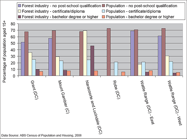
Figure A3.3: Proportion of population with different types of educational qualification – forest industry and total population aged over 15, 2006, South East – South Australia
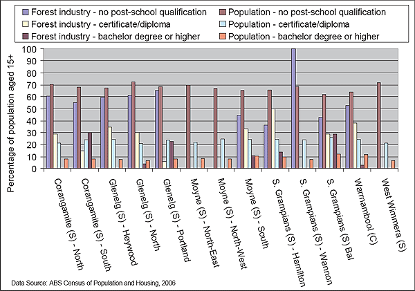
Figure A3.4: Proportion of population with different types of educational qualification – forest industry and total population aged over 15, 2006, Western District and Wimmera - Victoria
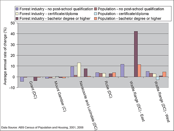
Figure A3.5: Average annual rate of change of population with different types of educational qualifications, 2001-2006, South East – South Australia
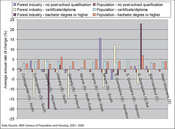
Figure A3.6: Average annual rate of change of population with different types of educational qualifications, 2001-2006, Western District and Wimmera - Victoria