
Publication date: 4 July 2016
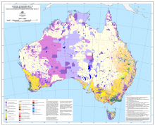
The Land use of Australia 2010-11 is a land use map of Australia for the year 2010-11. Agricultural land uses and their spatial distributions are based on the Australian Bureau of Statistics' 2010-11 agricultural census data. The spatial distribution of the agricultural land uses is modelled and was determined using Advanced Very High Resolution Radiometer (AVHRR) satellite imagery with training data to make agricultural land use allocations. The non-agricultural land uses are drawn from existing digital maps covering seven themes: topographic features, catchment scale land use, protected areas, World Heritage Areas, tenure, forest type and vegetation condition.
The Land use of Australia 2010-11 is supplied as a set of raster datasets (in Esri grid format) with coordinates referred to the Geocentric Datum of Australia 1994 (GDA94) with a 0.01 degree pixel size.
The Land use of Australia 2010-11 national map is an integer categorical summary land use grid, which has a value attribute table (VAT) with columns defining input layers and an output layer. The output layer specifies land use in terms of the Australian Land Use and Management Classification (ALUMC) Version 7 and is an approximation to a maximum likelihood map.
Also supplied are a set of 44 floating point probability grids for dryland and irrigated agricultural commodities. These grids are continuous probability surfaces which describe the spatial distribution of each of the agricultural commodity groups mapped. The value at each grid cell is the estimated probability, between 0 and 1, that the commodity is present at a given location. See the user guide for the names of the grids and the commodities they represent.
The Land use of Australia 2010-11 supersedes the Land Use of Australia, Interim Version 5, 2010-11 , which was published in July 2014.
The Land use of Australia 2010-11 is a product of the Australian Collaborative Land Use and Management Program (ACLUMP). ACLUMP, coordinated by ABARES, is a collaborative cross-government approach producing land use mapping products for Australia underpinned by common technical standards. The Department of Agriculture and Water Resources is acknowledged for its financial support of the Land use of Australia 2010-11.
The Land use of Australia datasets are recognised as Foundation Spatial Data by the Australia New Zealand Land Information Council and as an Essential Statistical Asset for Australia by the Australian Bureau of Statistics. Common applications of the datasets are in strategic planning and continental modelling.
Refer to the User guide for Land use of Australia 2010-11 for more information.
Downloads
Data
Land Use of Australia 2010-11 - User Guide PDF [0.3 MB]
Land Use of Australia 2010-11 - User Guide DOC [2.2 MB]
Land Use of Australia 2010-11 - Metadata TXT [20 KB]
General Downloads
Land Use of Australia 2010-11 - Summary statistics PDF [48 KB]
Land use of Australia 2010-11 - Land use map classified by commodity PDF [4.2 MB]