
This indicator (Indicator 1.1a) uses the area for each forest type over time as a broad measure of the extent to which forest ecosystems and their diversity are being maintained. Reporting on forest tenure aids our understanding of how different land management regimes may impact on forest biodiversity.
This part of Indicator 1.1a Area of forest by forest type and tenure, published December 2023, presents the area of Australia’s forests in Regional Forest Agreement regions by forest category, type and tenure.
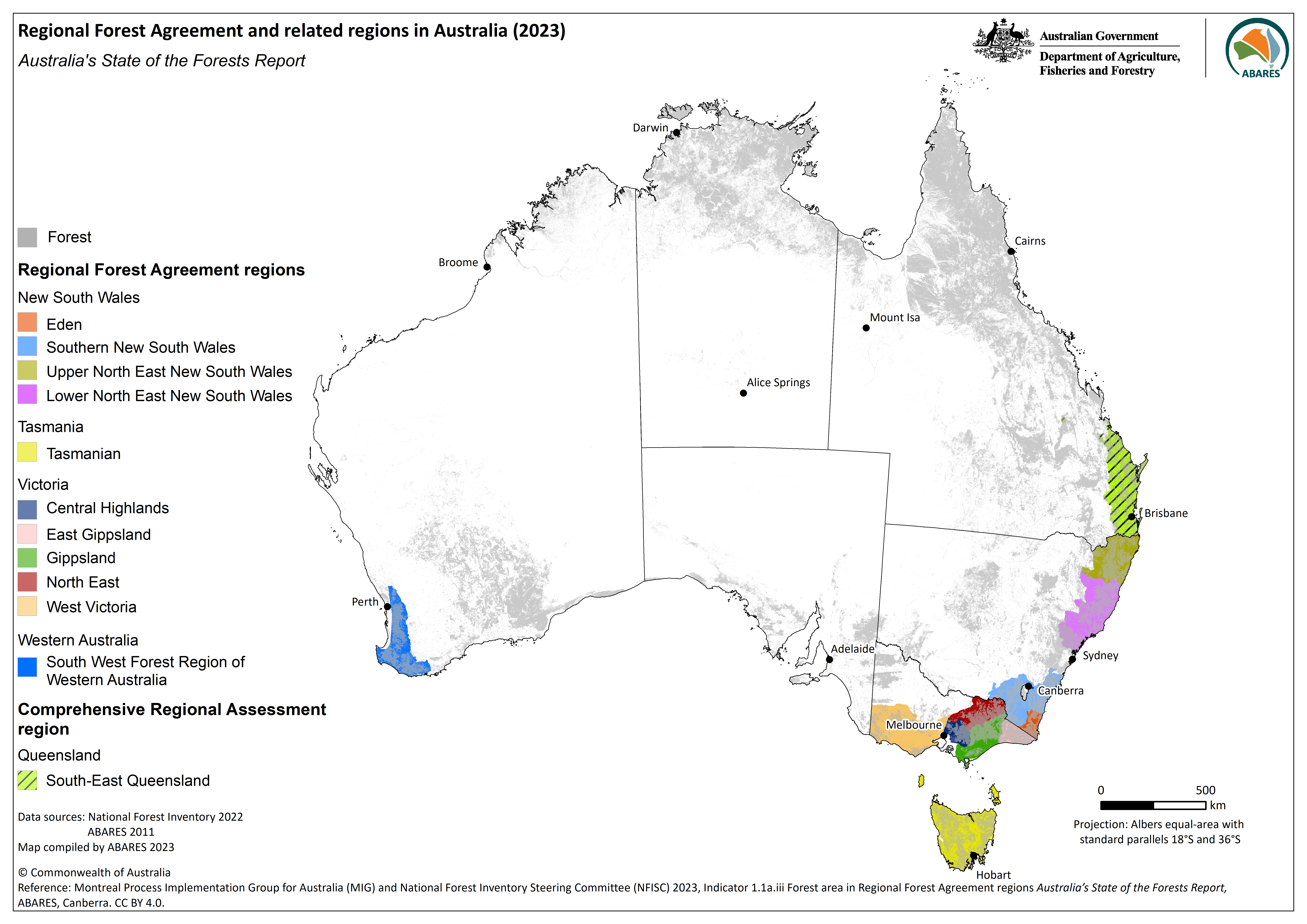
- Regional Forest Agreements (RFAs) are long-term Commonwealth–state agreements for the conservation and sustainable management of specific regions of Australia’s native and plantation forests.
- Ten RFAs across eleven regions cover 21.7 million hectares of forest in south-eastern and south-western Australia.
- RFAs cover 5% of Australia’s land area, contain 16% of Australia’s total forest area and account for 61% of the total area of multiple-use public native forest.
Regional Forest Agreements (RFAs) are long-term Commonwealth–state agreements for the conservation and sustainable management of specific regions of Australia’s native and plantation forests.
A key outcome of the National Forest Policy Statement was the negotiation of RFAs between the Australian Government and four state governments. The origins and development of Australia’s RFAs are described in Davey (2018). The RFAs were designed to balance the competing values placed on forests and provide certainty for forest-based industries, and were informed by science-based methodologies and Comprehensive Regional Assessments (CRAs) that determined forest allocation for different uses and underpinned forest management strategies.
Between 1997 and 2001 ten RFAs covering 11 regions were signed between the Australian Government and the New South Wales, Tasmania, Victoria and Western Australia state governments (Figure 1.1a.iii-1). The Upper North East and Lower North East RFA regions of New South Wales are covered by a single RFA. The Australian and Queensland governments completed a CRA for south-east Queensland, however an RFA was not signed and is not reported herein. Between 2017 and 2020 all ten RFAs were varied and extended. RFAs in New South Wales, Tasmania and Western Australia were extended on a 20-year rolling agreement, and RFAs in Victoria were extended to 2030.
Core objectives of RFAs were the promotion of ecologically sustainable forest management and sustainable yield of wood products, and the development of a comprehensive, adequate and representative (CAR) reserve system on public and private land. The scientific framework behind the CAR reserve system underpins the National Reserve System, Australia’s network of protected areas. Information on forests in protected area categories is reported in Indicator 1.1c. A compilation of data on reservation and resource availability outcomes for all RFA regions is reported in Jacobsen et al. (2020) using the forest ecosystems mapped at the time the RFAs were signed.

Click here to download a high-resolution version of Figure 1.1a.iii-1.
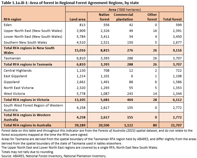
The ten RFAs across eleven RFA regions cover 39.2 million hectares of south-eastern and south-western Australia (Figure 1.1a.iii-1, Table 1.1a.iii-1), and include 21.7 million hectares of Australia’s forests (55% of the total area of RFA regions, and 16% of Australia’s total forest area).
The total forest area in RFA regions of 21.7 million hectares comprises: 20.5 million hectares of native forests (94% of all forest in RFA regions); 1.1 million hectares of commercial plantations (5.2%); and 0.1 million hectares of other forests (0.4%). The 1.1 million hectares of commercial plantations in RFA regions is 62% of the total area of Australia’s commercial plantations.
The largest areas of forest in RFA regions are found in: New South Wales (42% of total forest in RFA regions); Victoria (28%); Tasmania (17%); and Western Australia (13%).
The largest areas of forest by individual RFA regions (Table 1.1a.iii-1) are in the: Tasmanian RFA region (3.7 million hectares of forest); Lower North East New South Wales region (3.4 million hectares); and South West Forest Region of Western Australia (2.8 million hectares).
Click here for a Microsoft Excel workbook of the data for Table 1.1a.iii-1.
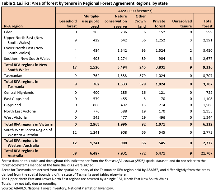
Forest in RFA regions occurs mostly across the three tenure classes of Nature conservation reserve, Multiple-use public forest and Private forest (Table 1.1a.iii-2):
- 7.9 million hectares of forest in RFA regions is on Nature conservation reserve (37% of all forest in RFA regions)
- 6.5 million hectares are on Multiple-use public forest tenure (30%)
- 6.5 million hectares are on Private tenure (30%).
RFA regions contain a significant portion of Australia’s total native forest area on Multiple-use public forest tenure. RFA regions cover 5.1% of Australia’s land area, but contain 16% of Australia’s total forest area, and account for 61% of the total area of Multiple-use public native forest.
RFA regions also contain 36% of Australia’s total native forest area on Nature conservation reserve tenure.
The tenure of forest land in RFAs varies across regions. Three RFA regions in New South Wales (Southern, Upper North East and Lower North East) contain smaller proportions of their forest area as Multiple-use public forest (15%, 18% and 14%, respectively), and larger proportions of their forest areas as either on Nature conservation reserve tenure (Southern, 48%) and Private forest tenure (Upper North East and Lower North East, 52% and 44% respectively). This contrasts with four RFA regions in Victoria (Central Highlands, East Gippsland, Gippsland and North East), which contain larger proportions of their forest area on Multiple-use public forest tenure (55%, 52%, 55% and 57%, respectively) and smaller proportions of their forest area on Private forest tenure (17%, 6%, 13% and 13% respectively).
Click here for a Microsoft Excel workbook of the data for Table 1.1a.iii-2.
Davey SM (2018). Regional forest agreements: origins, development and contributions, Australian Forestry 81: 64–88.
Jacobsen R, Davey SM, Read SM (2020). Regional forest agreements: compilation of reservation and resource availability outcomes, ABARES Technical report 20.11, Canberra, December.
Further information
Click here for Supporting information on 1.1a.iii Forest area by Regional Forest Agreement regions
- Forest types in RFA regions
- Differences in forest areas in RFA regions in 2018 and 2023
- Difference in forest areas in RFA regions in other reporting