
This is Supporting information for 1.1a.iii Forest area in Regional Forest Agreement (RFA) regions, published December 2023.
1.1a.iii Forest area in RFA regions is one of four parts of Indicator 1.1a Area of forest by forest type and tenure.
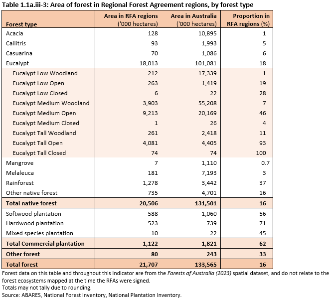
The national forest types are not evenly distributed across areas in and outside RFA regions. RFA regions include 16% of Australia's total native forest area and 18% of all Eucalypt forest, but they contain all 100% of Eucalypt tall closed forests, 93% of Eucalypt tall open forests, and 46% of the Eucalypt medium open forests, which are the three major forest types used for wood production. RFA regions also contain 37% of the total area of Rainforest (Table 1.1a.iii-3).
In contrast, RFA regions contain comparatively small proportions of other forest types, namely Casuarina (6% of total extent of this forest type), Callitris (5%), Melaleuca (3%), Acacia (1%) and Mangrove (0.7%) (Table 1.1a.iii-3). Only 0.6% by area of the Eucalypt mallee subtype is in RFA regions.
A total of 62% of the area of Australia's commercial plantations is in RFA regions, including 71% of hardwood plantations and 56% of softwood plantations (Table 1.1a.iii-3).
Click here for a Microsoft Excel workbook of the data for Table 1.1a.iii-3.
The forest area in RFA regions (21.7 million hectares) is 177 thousand hectares less than reported in SOFR 2018.
- The forest area in RFA regions in New South Wales, the Tasmanian RFA region and all RFA regions in Victoria except for the West Victoria RFA region was largely unchanged.
- The forest area in the West Victoria RFA region is 60 thousand hectares less than reported in SOFR 2018, due mostly to a decrease in the area of Other forest due to clearing of non-commercial plantations for agricultural purposes.
- The forest area in the South West Forest Region of Western Australia is 147 thousand hectares less than reported in SOFR 2018, due to a combination of corrections from improved mapping, and clearing of commercial plantations to non-forest for other land uses.
In the Upper and Lower regions of the North East New South Wales RFA region, the area of commercial plantations decreased by 25 thousand hectares (23% of the total commercial plantations in these regions), resulting from the clearing of plantations for agricultural purposes or from reclassification as non-commercial plantations and therefore Other forest.
The difference in forest area in RFA regions since 2018 by tenure class varies from region to region.
- In RFA regions in Victoria, updated tenure information drives the decrease in the extent of forest on Other Crown land (109 thousand hectares less than 2018) and on Private forest tenure (63 thousand hectares less), and an increase of forest reported on Multiple-use public forest tenure (104 thousand hectares more).
- In the South West Forest Region of Western Australia, most of the reported difference in forest area is on Private forest tenure (109 thousand hectares less than reported in SOFR 2018).
- In the Upper and Lower North East regions of the North East New South Wales RFA, an increase in 33 thousand hectares of forest on Nature conservation reserve tenure results from an increase in the area of national parks and other conservation reserves.
Information on forest areas in RFA regions in this Indicator is derived from the Forests of Australia (2023) dataset held in Australia’s National Forest Inventory. This dataset is assembled using a Multiple Lines of Evidence (MLE) (Mutendeudzi et al. 2013) approach that incorporates the most up-to-date versions of suitable regional and national spatial forest cover datasets.
Other reporting on forest areas in RFA regions may use different approaches to identify forest coverage, and thus may show different forest area figures for RFA regions. At signing, the RFAs used forest ecosystem mapping units that were derived from state-based forest mapping programs. Continued use of these forest ecosystems is an approach that provides a consistent baseline figure for reporting against RFA values over time, but does not take account of forest losses (such as through clearing or bushfires) or gains (such as through regrowth or re-establishment) that have occurred since signing the RFAs, and thus gives areas that differ from the current forest areas identified through the MLE approach and reported here.
A compilation of data on forests in RFA regions according to the original forest ecosystem mapping units is provided in Jacobsen et al. (2020).
Jacobsen R, Davey SM, Read SM (2020). Regional forest agreements: compilation of reservation and resource availability outcomes, ABARES Technical report 20.11, Canberra, December.
Mutendeudzi M, Read S, Howell C, Davey S, Clancy T (2013). Improving Australia's forest area estimate using a Multiple Lines of Evidence approach, ABARES Technical report 13.07, Canberra, November 2013.
Further information
Click here for Key information on 1.1a.iii Forest area in Regional Forest Agreement regions:
- What are Regional Forest Agreements?
- Forest area in RFA regions
- Tenure of forest in RFA regions