
Key issues
- During the week ending 7 April 2021, blocking high pressure systems resulted in little rainfall being recorded across much of Australia. In contrast, a low pressure trough to the northeast of Australia generated heavy rainfall across parts of northern and eastern Australia.
- The rainfall across cropping regions in Queensland has continued to cause harvest delays and grain quality issues for grain sorghum, with sprouted grain resulting in downgrading and lower prices for growers. The dry conditions in New South Wales, on the other hand, have been ideal for summer crop harvesting. The sowing of winter crops will begin in the coming weeks, and the heavy rainfalls during March have boosted soil moisture levels across eastern cropping regions.
- Oceanic and atmospheric indicators show a continued return to neutral El Niño-Southern Oscillation (ENSO) conditions, reducing its influence on Australia’s weather patterns. While the presence of the Madden-Julian Oscillation (MJO) in the Australian region is likely to result in above average rainfall for northern Australia, the return to neutral ENSO conditions may result in below average rainfall for much of eastern Australia through the remainder of the 2021 autumn.
- There is a 50% chance of recording average April rainfall totals across much of Australia, including most cropping regions in Victoria, South Australia and Western Australia. An early autumn break has already occurred for much of the New South Wales and Western Australian cropping regions. However, western Victorian and South Australian cropping regions are less likely to receive sufficient rainfall to constitute an autumn break in April.
- Tropical Cyclone Seroja is likely to bring strong winds and rainfall to parts of Western Australia. Troughs over the interior will bring isolated rainfall, while a cold front in the southeast will likely result in heavy rainfall in Tasmania.
- In Australia’s cropping regions over the next eight days, little to no rainfall is expected across much of New South Wales, Queensland, Victoria and South Australia. Rainfall totals of between 10 and 50 millimetres are expected across cropping regions in Western Australia. The low rainfall conditions expected in the northern cropping regions of New South Wales and Queensland will allow late harvesting of summer crops to continue, as well as field preparation and sowing of winter crops.
- Water storage in the Murray–Darling Basin (MDB) increased by 11 gigalitres (GL) between 31 March 2021 and 7 April 2021. The current volume of water held in storage is 14,172 GL, which represents 56% of total capacity. This is 68% or 5,731 GL more than at the same time last year.
- Allocation prices in the Victorian Murray below the Barmah Choke remained steady at $75 per ML between 1 April 2021 and 8 April 2021. Prices are lower in the Murrumbidgee due to binding of the Murrumbidgee export limit.
Climate
[expand all]
Rainfall this week
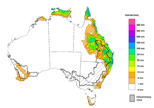
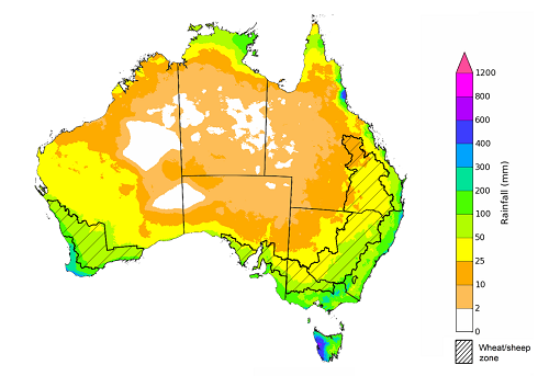
During the week ending 7 April 2021, blocking high pressure systems resulted in little rainfall being recorded across much of Australia. In contrast, a low pressure trough to the northeast of Australia generated heavy rainfall in parts of tropical northern Australia, the far northeast of New South Wales and large areas of eastern Queensland.
Rainfall totals of between 10 and 50 millimetres were recorded across isolated parts of eastern New South Wales, much of eastern Queensland and the north of the Northern Territory. Rainfall in excess of 50 millimetres was recorded in the northeast of New South Wales, parts of eastern, central and northern Queensland, and the north of the Northern Territory.
In cropping regions, rainfall of between 5 and 50 millimetres was recorded across much of Queensland, with rainfall in excess of 50 millimetres in eastern and northern parts. Little to no rainfall was observed across most cropping regions in New South Wales, Victoria, South Australia and Western Australia.
The rainfall across cropping regions in Queensland has continued to cause harvest delays and grain quality issues for grain sorghum, with sprouted grain resulting in downgrading and lower prices for growers. The dry conditions in New South Wales, on the other hand, have been ideal for summer crop harvesting. The sowing of winter crops will begin in the coming weeks, and the heavy rainfalls during March have boosted soil moisture levels across eastern cropping regions.
Rainfall for the week ending 7 April 2021
©Commonwealth of Australia 2021, Australian Bureau of Meteorology - Issued: 7/04/2021
Note: The rainfall analyses and associated maps utilise data contained in the Bureau of Meteorology climate database, the Australian Data Archive for Meteorology (ADAM). The analyses are initially produced automatically from real-time data with limited quality control. They are intended to provide a general overview of rainfall across Australia as quickly as possible after the observations are received. For further information go to http://www.bom.gov.au/climate/rainfall/
Climate Drivers
As planting begins for the winter cropping season, the key Australian winter climate drivers to watch are the El Niño–Southern Oscillation (ENSO), the Indian Ocean Dipole (IOD) and the Madden–Julian Oscillation (MJO). These climatic patterns can have a large influence on autumn and early winter rainfall across Australia.
Oceanic and atmospheric indicators show a continued return to neutral ENSO conditions, reducing its influence on Australia’s weather patterns. The La Niña event of spring and summer 2020-21 brought above average rainfall in northern and eastern Australia. The favourable growing conditions resulting from the La Niña event were central in developing ABARES summer crop and livestock production forecasts embodied in the ABARES March 2021 edition of the Agricultural commodities and February 2021 edition of the Australian crop report. While the presence of the MJO in the Australian region is likely to result in above average rainfall for northern Australia, the return to neutral ENSO conditions may result in below average rainfall for much of eastern Australia through the remainder of the 2021 autumn.
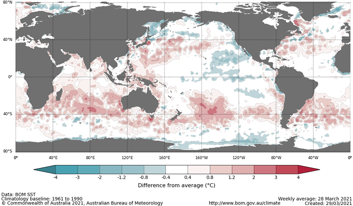
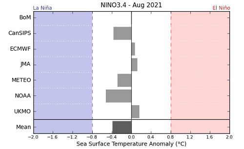
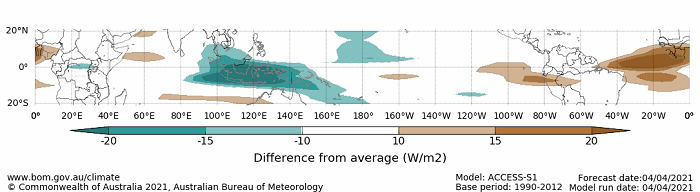
Sea surface temperature anomalies across much of the tropical Pacific Ocean have continued to weakened over the past two weeks. The below average temperatures had remained steady through summer but have largely seen a return to the long-term average. As at 30 March 2021 all of the international climate models surveyed are expecting sea surface temperature across the tropical Pacific Ocean to return to neutral ENSO values by May and remain neutral until at least August. Sea surface temperatures near Western Australia, as well as sea surface temperatures near Indonesia and the Philippines, have remained above average
Difference from average sea surface temperature observations 22 March to 28 March 2021
International climate model outlooks for the NINO 3.4 region in August 2021
©Commonwealth of Australia 2021, Australian Bureau of Meteorology - Issued: 30/03/2021
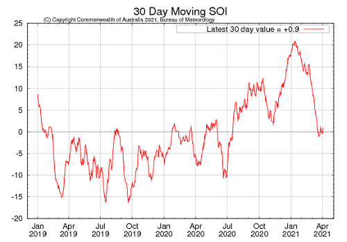
According to atmospheric indicators, the La Niña event has continued to ease with a return to neutral conditions. Trade wind strength has increased over the past couple of weeks, remaining above average. The increase in trade wind strength is likely due to the presence of the MJO in the Australia region, rather than ENSO-related. Cloudiness near the Date Line remains below average. For the period ending 4 April the 30-day South Oscillation Index (SOI) value was +0.9 and for the period ending the 28 March the 90-day value was +10.9. The 30-day SOI has stabilised below the La Niña threshold value of +7, while the 90-day SOI has continued to trend downwards but remains above the threshold. Overall, the SOI values suggest a likely return to neutral conditions.
30-day Southern Oscillation Index (SOI) values ending 4 April 2021
As at 4 April 2021 the MJO is of moderate strength and currently located in the Australian region. The MJO is a pulse of cloud and rainfall that moves eastward along the equator. The presence of the MJO north of Australia is likely to result in above average cloudiness and rainfall across northern Australia. Climate models predict the MJO will weaken and dissipate towards the middle of April.
Madden–Julian Oscillation (MJO) daily index
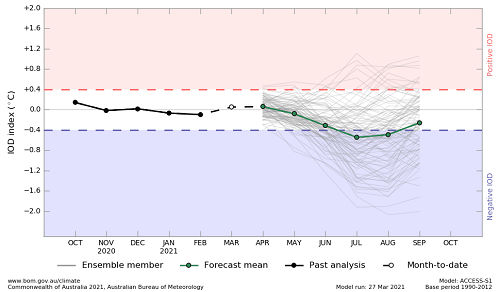
Sea surface temperatures have been warmer than average across much of the Indian Ocean, potentially influencing local weather conditions in Western Australia. As at 28 March, the Indian Ocean Dipole (IOD) weekly value was +0.22°C which is neutral. Most climate models expect the IOD to remain neutral throughout autumn with three of the five international models predicting the IOD to reach or exceed the negative threshold (-0.4°C) by July. Accuracy of the models at this time of year is lower than at other times, and outlooks should be interpreted with caution. A negative IOD is associated with above average winter and spring rainfall across southern Australia, as well as the far north. It is also associated with an early northern rainfall onset.
Monthly sea surface temperature anomalies for IOD region
National Climate Outlook
These climate outlooks are generated by ACCESS–S (Australian Community Climate Earth-System Simulator–Seasonal). ACCESS–S is the Bureau of Meteorology's dynamical (physics-based) weather and climate model used for monthly, seasonal and longer-lead climate outlooks.
For further information, go to http://www.bom.gov.au/climate/ahead/about/
The Bureau of Meteorology’s latest rainfall outlook indicated wetter than average conditions are more likely for parts of northern Australia due to the presence of a moderate strength MJO in the region. Drier than average conditions are expected for much of eastern Australia as the ENSO returns to neutral.
The outlook for April 2021 indicates that there is a 75% chance of rainfall totals between 10 and 100 millimetres across the northern, eastern and southern coasts of Australia, as well as much of Tasmania. Rainfall totals in excess of 100 millimetres are expected across isolated parts of northern Queensland and the far north coast of the Northern Territory and western Tasmania.
Across cropping regions there is a 75% chance of rainfall total of between 5 and 10 millimetres across parts of eastern New South Wales, isolated parts of Queensland, northern Victoria, as well as much of South Australian and Western Australian cropping regions. There is a 75% chance of rainfall totals between 10 and 15 millimetres for isolated parts of southern New South Wales, Victoria, South Australian and Western Australian cropping regions.
The ACCESS-S climate model suggests there is a 50% chance of recording average or better April rainfall totals across much of Australia, including most cropping regions in Victoria, South Australia and Western Australia. An early autumn break has already occurred for much of the New South Wales and Western Australian cropping regions. Tasmania is likely to experience an autumn break in April; however, western Victorian and South Australian cropping regions are less likely to receive sufficient rainfall to constitute an autumn break in April. The rainfall outlook for April will provide ideal conditions for harvesting of late-sown summer crops and planting of winter crops in the northern cropping regions.
Rainfall totals that have a 75% chance of occurring April 2021
The rainfall outlook for April to June 2021 suggests there is a greater than 60% chance of above average rainfall across much of northern Australia and parts of Western Australia. There is less than a 40% chance of exceeding median rainfall across much of New South Wales, Queensland and Victoria, as well as parts of South Australia (Bureau of Meteorology ‘National Climate Outlook’, 1 April 2021). Bureau of Meteorology rainfall outlooks for April to June have greater than 65% past accuracy across isolated parts of Australia. The outlooks have less than 50% accuracy (no better than random chance) across large parts of New South Wales, South Australia and Western Australia.
Chance of exceeding the median rainfall April to June 2021
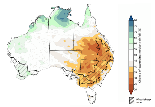
©Commonwealth of Australia 2021, Australian Bureau of Meteorology Issued: 1/04/2021
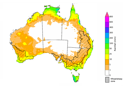
The outlook for April to June suggests there is a 75% chance of rainfall totals between 25 and 100 millimetres across much of New South Wales, eastern Queensland, northern Victoria, the south of Southern Australia, the southwest of Western Australia, the north of the Northern Territory and eastern Tasmania. Rainfall totals in excess of 100 millimetres are likely across the east of New South Wales, isolated parts of eastern Queensland, southern Victoria, isolated parts of the south of South Australia and Western Australia, and western Tasmania.
Across cropping regions, there is a 75% chance of receiving between 25 and 50 millimetres in parts of western New South Wales, much of Queensland, northwest Victoria and parts of South Australia. Rainfall totals above 50 millimetres are expected in eastern New South Wales, southern Victorian and much of the South Australian and Western Australian cropping regions. Totals of less than 25 millimetres are expected in the north and west of Queensland’s cropping region.
There is a 50% chance of recording at least average April to June rainfall across most winter cropping regions in Victoria, South Australia and Western Australia. Meanwhile, cropping regions in New South Wales, Queensland and parts of northern Victoria have less than a 50% chance of recording average April to June rainfall. Average to above average soil moisture levels in New South Wales, Queensland and parts of the Victorian are likely to still provide good conditions for planting of winter crops despite the lower probabilities of receiving close to average rainfall totals in the coming months.
Rainfall totals that have a 75% chance of occurring April to June 2021
©Commonwealth of Australia 2021, Australian Bureau of Meteorology Issued: 1/04/2021
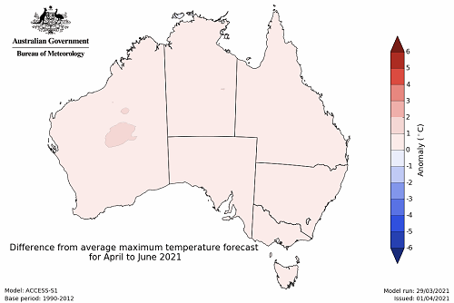
The temperature outlook for April to June 2021 indicates that day-time and night-time temperatures across most of Australia are likely to be close to the 1990-2012 average (- 1°C to 1°C) (Bureau of Meteorology ‘National Climate Outlook’, 18 April 2021).
Predicted maximum temperature anomaly for April to June 2021
Predicted minimum temperature anomaly for April to June 2021

Rainfall forecast for the next eight days
Tropical Cyclone Seroja is likely to bring strong winds and rainfall to parts of Western Australia. Troughs over the interior will bring isolated rainfall to northern Queensland, while a cold front in the southeast will likely result in heavy rainfall in Tasmania and isolated areas of southern Victoria.
Rainfall totals of between 10 and 50 millimetres are forecast for isolated parts of eastern New South Wales, northern Queensland, southern Victoria, the west of Western Australia and eastern Tasmania. Rainfall totals in excess of 50 millimetres are forecast for parts of northern Queensland and western Tasmania.
In Australia’s cropping regions, little to no rainfall is expected across much of New South Wales, Queensland, Victoria and South Australia. Rainfall totals of between 15 and 50 millimetres are expected across cropping regions in Western Australia. The low rainfall conditions expected in the northern cropping regions of New South Wales and Queensland will allow late harvesting of summer crops to continue, as well as field preparation and sowing of winter crops.
Total forecast rainfall (mm) for the period 8 April to 15 April 2021
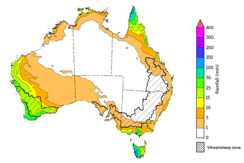
©Commonwealth of Australia 2021, Australian Bureau of Meteorology - Issued: 08/04/2021
Note: This rainfall forecast is produced from computer models. As the model outputs are not altered by weather forecasters, it is important to check local forecasts and warnings issued by the Bureau of Meteorology.
Water
Water storages, water markets and water allocations - current week
The Tableau dashboard may not meet accessibility requirements. For information about the contents of these dashboards contact ABARES.

Commodities
Information on weekly price changes in agricultural commodities is now available at the Weekly commodity price update.