
Key issues
- In the week ending 1 May 2024, dry conditions dominated much of Australia. Rainfall was limited to the far north, parts of the eastern and southern coasts, Tasmania, and in patchy areas in the inland Western Australia.
- Across cropping regions, rainfall totals of up to 25 millimetres were observed in central New South Wales. Little to no rainfall was recorded in remaining cropping areas. A lack of rainfall in the recent week will likely delay germination of dry sown winter crops, especially in areas where upper layer soil moisture is low.
- Over the coming days, much of the western parts of the country is forecast to be dry. Onshore winds in the east are expected to bring rainfall totals of up to 200 millimetres in New South Wales and up to 50 millimetres in southern Queensland.
- Across cropping areas, conditions are expected to be largely dry in the south. In the east, a maximum of 50 millimetres is expected in New South Wales and southern Queensland.
- A dry week in Western Australia and South Australia will continue to see a decline in soil moisture levels.
- In April, the national rainfall was 26% below average. Rainfall was generally high across the east and northern tropics, and below average across southern, central and south-western parts of the country.
- Following March and April rainfall, large areas of cropping regions in New South Wales, southern Queensland, eastern Victoria and eastern parts of Western Australia have received an early autumn break. However, April rainfall has consolidated early autumn break in March only in parts of New South Wales and southern Queensland.
- Across cropping regions, April upper- and lower-layer soil moisture was generally average to well above average in New South Wales, Queensland and Victoria. This likely has placed the eastern states in an ideal start to planting winter crops. However, extremely low soil moisture in South Australia and Western Australia was recorded.
- For the 3 months to April 2024, above average rainfall totals resulted in average to well above average pasture production for this time of year across most grazing regions. High pasture availability will likely enable farmers to continue to maintain current stock numbers and provide opportunities to build standing dry matter availability.
- Water storage levels in the Murray-Darling Basin (MDB) decreased between 18 April 2024 and 29 April 2024 by 255 gigalitres (GL). Current volume of water held in storage is 16 605 GL, equivalent to 75% of total storage capacity. This is 15 percent or 3397 GL less than at the same time last year. Water storage data is sourced from the BOM.
- Allocation prices in the Victorian Murray below the Barmah Choke decreased from $21 on 18 April 2024 to $20 on 02 May 2024. Prices are lower in the Murrumbidgee due to the binding of the Murrumbidgee export limit.
Climate
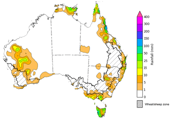
For the week ending 1 May 2024, dry conditions dominated much of Australia. Rainfall was limited to the far north, parts of the eastern and southern coasts, Tasmania, and in patchy areas in the inland Western Australia. A cold front passed over Tasmania, bringing rainfall totals of up to 100 millimetres in the west.
Across cropping regions, rainfall totals of up to 25 millimetres were observed in in central New South Wales. Little to no rainfall was observed in remaining cropping areas. Moving into the winter growing season, a lack of rainfall in the recent week will likely delay germination of dry sown winter crops in areas where upper layer soil moisture is low.
Rainfall for the week ending 1 May 2024
Note: The rainfall analyses and associated maps utilise data contained in the Bureau of Meteorology climate database, the Australian Data Archive for Meteorology (ADAM). The analyses are initially produced automatically from real-time data with limited quality control. They are intended to provide a general overview of rainfall across Australia as quickly as possible after the observations are received.
For further information go to http://www.bom.gov.au/climate/rainfall/
Over the 8 days to 9 May, low-pressure systems and troughs are expected to bring rainfall in the southwest, east, and far north coasts. Onshore winds in the east are expected to bring rainfall totals of up to 200 millimetres in New South Wales and up to 50 millimetres in southern Queensland. Up to 50 millimetres of rainfall is forecast in the far-north Northern Territory, north Queensland, and southwestern Western Australia. A high-pressure system is expected to keep much of Australia largely dry.
Across cropping regions, conditions are expected to be largely dry in the south, with a maximum of 15 millimetres of rainfall forecast for Western Australian cropping regions, and 5 millimetres in South Australia and Victoria. These areas are likely to see a continuing decline in upper layer soil moisture and may present a downside production risk for winter cropping systems. In the east, a maximum of 50 millimetres is expected in New South Wales and south Queensland. This will boost soil moisture reserves for the beginning winter cropping season
Total forecast rainfall for the period 02 May to 9 May 2024
![Map of the total forecast rainfall for the next 8 days. Image provided by the Bureau of Meteorology. Please refer to accompanying text for a more detailed description.]](/sites/default/files/images/forecast%20week%20rain-240502.png)
Note: The rainfall analyses and associated maps utilise data contained in the Bureau of Meteorology climate database, the Australian Data Archive for Meteorology (ADAM). The analyses are initially produced automatically from real-time data with limited quality control. They are intended to provide a general overview of rainfall across Australia as quickly as possible after the observations are received.
For further information go to http://www.bom.gov.au/climate/rainfall/
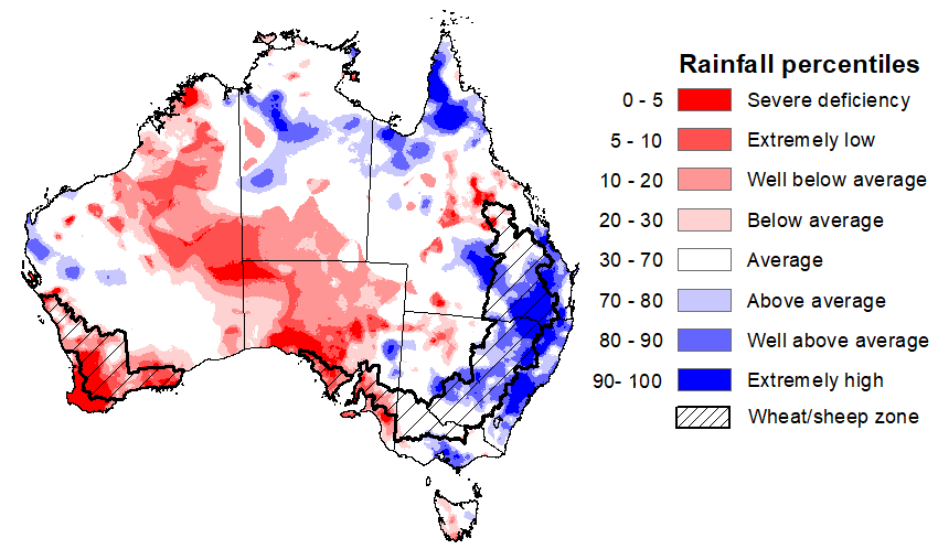
In April 2024, national rainfall was 26% below average, and 86% below average in South Australia (the 8th driest April on record), and 69% below average in Western Australia. Rainfall was generally high across the east and northern tropics, and below average across southern, central and south-western parts of the country. Rainfall was average to very much above average for eastern New South Wales extending into inland areas, Victoria, small areas in Western Australia’s Pilbara region, Top End of Northern Territory, and much of northern and south-eastern Queensland.
In cropping regions, rainfall across Western Australia and South Australia was predominately below average to extremely low. By contrast Queensland and New South Wales saw rainfall ranging from average in north Queensland and southern New South Wales to extremely high in the remaining areas. Victorian cropping regions saw average rainfall over the period.
As we transition into the remainder of the autumn season, the focus shifts from summer crop and pasture growth across Northern Australia to ensuring adequate rainfall to prepare for the winter cropping season and peak pasture production in the south. This is especially crucial in regions that received below-average rainfall in April. Given a below median rainfall outlook for May, and May to July period in parts of the southern regions, this necessitates a careful monitoring and strategic planning to mitigate potential impacts on upcoming winter crops and managing ground cover and livestock numbers.
Rainfall percentiles for April 2024
Early autumn break
An early autumn break was achieved between March and April 2024 across cropping regions of most of New South Wales, areas in southern Queensland, eastern Victoria and eastern parts of Western Australia.
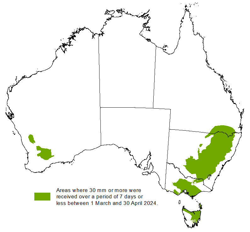
An early autumn break can increase the length of the growing season, potentially improving production and yield. The definition of the autumn break in southern Australia varies. Pook et al. (2009) suggested an ideal break for north-western Victoria occurs during March–June when a mean fall of 25 millimetres or more is recorded over a period of 3 days or less, or when a mean fall of 30 millimetres or more is recorded over a period of 7 days or less.
ABARES has adapted the Pook et al. (2009) autumn break definition of falls of 30 millimetres or more recorded within any 7-day period from 1 March to 30 April to identify where the autumn break threshold has been achieved across southern Australia.
ABARES analysis of daily rainfall data sourced from the Bureau of Meteorology indicates that the autumn break has been achieved across most cropping regions in New South Wales, eastern Victoria, southern Queensland and eastern parts of Western Australia. An autumn break has not been achieved in the remaining cropping regions.
Southern pasture and cropping areas that have achieved 30 millimetres in any 7‐day period from March to April, 2024
The timing of the early autumn break can have an influence on the production outcome of the upcoming winter growing season. However, the consolidation of this break with timely follow-up falls is important in determining the ultimate benefits of the autumn break. For example, a 30mm rainfall event over a period of 7 days or less in March followed by warm, dry weather during April is likely to constitute a ‘false’ break and can have a net negative impact on production. An early autumn break does not guarantee a successful growing season; sufficient winter and spring rainfall is still required, particularly in areas with little to no stored soil moisture, to deliver a successful crop and pasture production season.
Rainfall during April has consolidated the early autumn break across central and eastern margins of New South Wales, and southern Queensland. These falls have continued to improve soil moisture profiles and allowed for an ideal start to winter crop planting and autumn pasture growth in these areas. In South Australia, Victoria and Western Australia, the dry period increases the risk of plants experiencing moisture stress after germination, with a disconnect emerging between upper- and lower-layer soil moisture.
Areas that have received at least 25 millimetres of follow-up rainfall from 1 to 30 April 2024
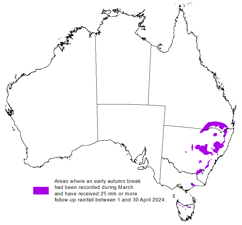
Note: The autumn break generally applies to the southern pasture and cropping areas mainly in New South Wales, Victoria, South Australia, Western Australia and Tasmania — and occasionally parts of southern Queensland. Areas that are not typically influenced by the autumn break have been shaded out.
Image
Upper layer soil moisture levels for April 2024 varied considerably throughout Australia. High levels of upper layer soil moisture were modelled in the northern and eastern Australia, showing very much above average upper layer soil moisture. In contrast, upper layer soil moisture in the south and northwest was modelled to be below average. Average levels of upper layer soil moisture was modelled for much of Australia.
At this time of year, upper layer soil moisture is important for the germination and establishment of early sown winter crops across Australian cropping regions.
Across cropping regions, April upper layer soil moisture was highly variable, with Western Australia, South Australia and far western Victoria having below average. By contrast, upper layer was average in most of eastern Victoria, southern New South Wales and northern Queensland, and very much above average in northern New South Wales and much of central to southern Queensland.
Modelled upper layer soil moisture for April 2024
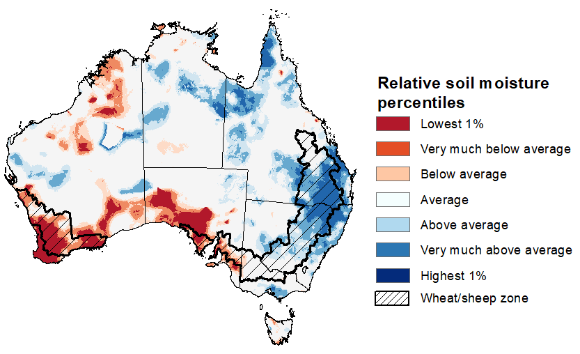
Source: Bureau of Meteorology (Australian Water Resources Assessment Landscape model)
Across northern Australia, lower layer soil moisture was average to very much above average in April. However, areas of below average lower layer soil moisture were evident in southern Australia. Average levels of lower layer soil moisture was modelled for remaining Australia.
Lower layer soil moisture plays a pivotal role in sustaining the growth of winter crops and pasture during their critical development stages. Across Australian cropping regions, lower layer soil moisture generally ranged from average to very much above average across New South Wales and Queensland, and generally average in Victoria. Deficient levels of soil moisture in South Australia.
Modelled lower layer soil moisture for April 2024
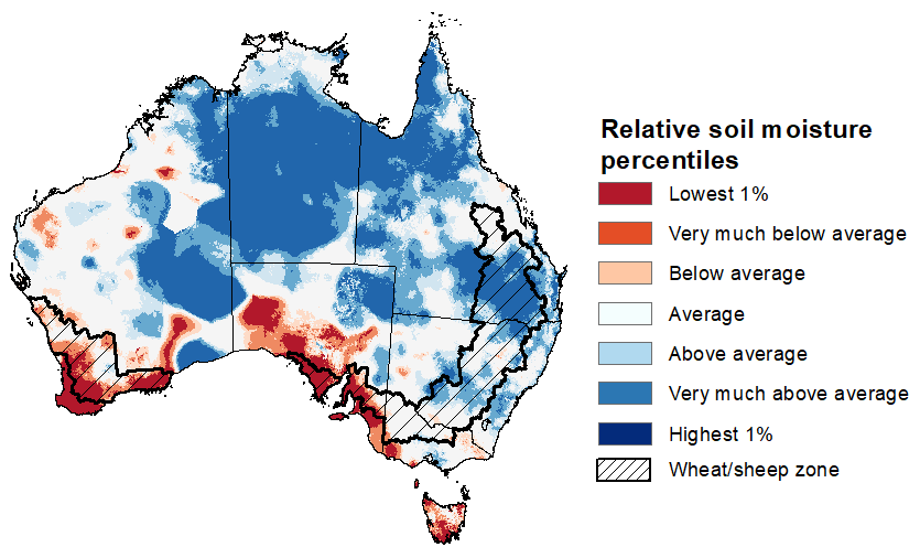
Source: Bureau of Meteorology (Australian Water Resources Assessment Landscape model)
February to April forms the final 3-months of the pasture growing season across much of northern Australia, providing a late season boost in growth and the bulk of feed to maintain production through the low pasture growth months of the northern dry season. Pasture availability during this period influences the growth and branding and marking rates of lambs and calves, livestock turnoff and the production of meat, milk, and wool.
For the 3 months to April 2024, above average rainfall totals resulted in average to well above average pasture production for this time of year across most grazing regions. However, extremely low to below average pasture growth rates were recorded across western parts of Western Australia, western New South Wales, southern South Australia, and parts of southern and eastern Victoria and central Tasmania.
Above average to extremely high pasture availability will likely enable farmers to continue to maintain current stock numbers and provide opportunities to build standing dry matter availability.
Relative pasture growth for 3-months ending April 2024 (1 February to 30 April 2024)
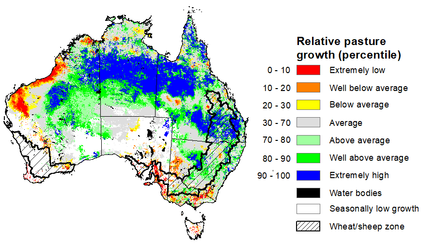
Source: Queensland Department of Science, Information Technology and Innovation
Water
Water storages, water markets and water allocations - current week
The Tableau dashboard may not meet accessibility requirements. For information about the contents of these dashboards contact ABARES.

Commodities
Information on weekly price changes in agricultural commodities is now available at the Weekly commodity price update.