
The Australian Plague Locust Commission (APLC) monitors the population status of the three pest locust species listed under its charter using a range of information sources, including surveys undertaken by APLC officers, light trap information and reports from the public and state agriculture authorities.
The information on current locust distributions is used with meteorological and environmental information to produce short-term forecasts of likely population developments or migrations. These are summarised in the Current situation web page and the Locust bulletin.
Monitoring
[expand all]
Surveys
The APLC monitors locust populations in eastern Australia by conducting regular ground surveys in the major breeding areas. Field officers located at bases in Narromine, Broken Hill (NSW) and Longreach (Queensland) conduct surveys according to seasonal timing and habitat conditions.
The standard method of survey is vehicle-based, making regular stops (about every 10 km) to conduct 250 m foot transects. For each species, the number encountered at different development stages is recorded, as well as the type and condition of ground vegetation. Information is captured on-site and transferred to a Geographic Information System (GIS) at APLC Canberra HQ.
Field officers also contact local landholders and officers from relevant state and regional agencies to exchange information on the current locust situation.
Fixed wing aircraft or helicopters may be used to survey large areas that require rapid assessment. This typically occurs when an upsurge is expected or detected, or when conditions make ground survey impossible.
Reports
The APLC makes extensive use of reports of any locust activity from landholders and the general public. These are subsequently checked by APLC or other agency officers to verify the species and density. See the Reporting Locusts page for details on reporting locust activity to the APLC.
Light traps
Locusts can migrate hundreds of kilometres in a single night and may do so on successive nights. The APLC operates a network of light traps across eastern Australia to assist in detecting nocturnal activity or long distance migration of locusts. Night flying locusts in the vicinity of the trap are attracted to light. Sudden increases in locust numbers caught often indicate regional nocturnal activity, including possible long distance migration.
Light traps are operated throughout the locust season from August until the end of May. The number of each locust species caught is recorded daily.
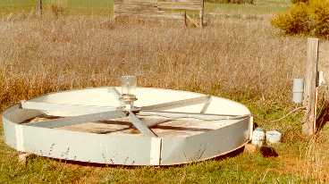
A light trap designed to monitor locust migration.
Adult locusts flying during the night are attracted to the 250W
mercury vapour lamp and fall into the base filled with water where
they are identified and counted the following morning
Insect monitoring radars
The APLC maintains an insect monitoring radar (IMR) developed in collaboration with the University of NSW - Australian Defence Force Academy (ADFA). This narrow-beam, vertical X-band radar is located at Bourke (NSW) and operates automatically each night. The signals of insects flying through the beam are automatically processed to produce graphical dynamic summaries of displacement, height and characteristics of individual insects. This information is used to interpret the direction and destination of locust migrations and to infer likely population redistributions. A second IMR unit is currently being refurbished and is likely to be located in southern NSW.
Forecasting
[expand all]
Forecasts of locust development
Regional forecasts are produced monthly for the current and following generation, with general forecasts of up to three months during summer and projections of up to eight months from autumn to spring. Forecasts are provided to state agencies and the public through the APLC website, and used internally for operational planning to help locate population aggregations early in a breeding sequence.
Regional risk statements take into account both the probability and consequences for agriculture of possible outcomes.
Regional forecasts and seasonal outlook are based on
- current population distribution and development stages
- recent rainfall and habitat condition
- seasonal rainfall expectation
- historical frequency of infestations
- long-term meteorological indices
- habitat stratification
Australian plague locusts
The rate at which individual locusts pass through each stage is determined primarily by temperature. Rainfall influences the timing of certain developmental milestones in eggs indirectly through soil moisture and the development rate of nymphs and sexual maturation of adults through food supply. Nymph and adult locusts are also able to regulate their body temperature by basking in the sun or finding shade. Previous basic research on the development rates of eggs and nymphs over a range of constant temperatures were used to develop simple lifestage-specific models to predict the timing of locust developmental stages based on temperatures in the field. The model for the egg stages includes diapause and quiescence, which delay the time at which eggs will hatch.
The growth of juvenile locusts, called nymphs or hoppers, occurs in discrete stages called instars. In Australian plague locusts there are typically five instars. Adults also pass through stages of maturation and egg development before laying.
The known development stage and population density of locusts in different locations is used to initialise the development models. Nymphal development in locations where population development is not known are also be modelled, using likely prior egg-laying activity associated with rainfall.Spur-throated and migratory locusts
The development of spur-throated and migratory locusts is also influenced by temperature, but the lifecycles and species requirements differ. The spur-throated locust has only one generation per year, and generally spends the winter as immature adults. Egg development by young adults takes place at the start of the wet season. The hoppers of this locust pass through more instars before reaching adulthood and the number of instars varies depending upon conditions and the gender of the individual; typically, male hoppers have 6 to 7 instars whereas female hoppers have 7 to 8 instars. The migratory locust has similar rates of egg and nymph development to the Australian plague locust, but does not have strong egg quiescence in dry soil. Australian migratory locust populations do not have an egg diapause and can have several generations each year.
Mapping suitable habitat and vegetation conditions
Satellite images of vegetation greenness are used to identify areas where ground vegetation in locust habitat areas has responded to rainfall and might provide suitable conditions for locust survival, breeding and potential population increase. Current vegetation index imagery is available within two weeks of the satellite observation period and is a factor in determining where locust surveys will be carried out.
The condition of vegetation is also assessed directly during survey by recording the presence and amount of green leaf material on a scale from green shooting to completely dry, for several ground vegetation components (perennial grasses, ephemeral grasses and forbs).
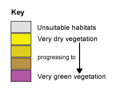
The example image below shows the relative greenness of vegetation in broad locust habitat areas for the 14-day period beginning on 20 March 2010, during a major locust population build-up.
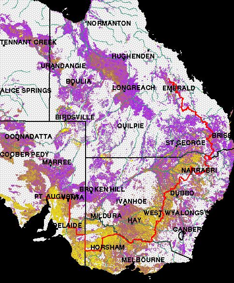
Source: Landgate - Government of Western Australia (Satellite Remote Sensing Services)
NB: the APLC area of operations is to the west and north of the red line.
The image above shows where vegetation is green using the Normalised Difference Vegetation Index (NDVI) obtained from the MODIS instruments on board US National Aeronautics and Space Administration (NASA) earth observation satellites. In arid and semi-arid areas of Australia, open plain landscapes with a sparse covering of grasses and forbs are important habitats for locust breeding, especially when plants produce new growth following rain. Landscapes such as forest and scrub, dunes and rocky hills are largely unsuitable for locust breeding and have been masked out in grey to emphasise the condition of predominantly grassy vegetation in locust habitats. The image is re-scaled to show current NDVI values as a proportion of the historic range in values for the same locations. This highlights growth in response to rainfall in sparsely vegetated landscapes relative to much larger NDVI values for dense vegetation, such as forests or crops.
APLC Decision Support System for monitoring and forecasting locust populations
The APLC uses a GIS based computer interface to assist locust forecasting and operations. The data collection components include transfer of locust survey data from the field and daily internet collections of weather data. Locust distribution and age information collected by APLC officers, with data captured digitally on-site during field surveys transferred daily to the GIS server at APLC Canberra HQ.
The system consists of a set of computerised secondary decision tools that have been added or modified as technology, information sources and operational needs change. These provide access to databases, simulation models, spatial analyses and maps to support both forecasting and operations, and are designed to give experienced staff access to relevant primary or derived information. For operations it provides map overviews and detailed regional views of the current locust situation that can be combined with relevant environmental conditions and infrastructure, thereby assisting with targeting survey and control operations.
This enables the integration of environmental factors which determine habitat suitability and influence locust distribution and recruitment with known distributions, to model population development across the entire monitoring area. In this way short term predictions of development stage and reproductive success can be made for known and potential populations at different locations.
The primary management decisions - the early intervention strategy, control opportunities, constraints and methodology, the use of spotter and spray aircraft - utilize the experience gained from research and operations. Operational campaign decisions - population thresholds to launch or cease campaigns, control agent, technique and identification of targets - require intensive field assessment and are made by officers conducting a control campaign.
Forecasting support tools
- Daily weather analyses – rainfall, temperature, wind fields
- Locust distributions- survey data
- Stage-specific development models using DYMEX
- Wind trajectory analysis
- Processed data outputs from Insect Monitoring Radar (IMR)
- Satellite vegetation greenness index (NDVI) imagery
Operations access tools
- Field survey data collection, transfer and GIS processing
- Display interface to survey and control information
- Historical locust databases
- Landuse limitations – nature conservation, organic production, threatened species
- Control information navigation and data management software
- Property control maps
- DGPS target logfile conversion and management
Online support tools
- Regional weather forecasts and observations
- Bureau of Meteorology weather radar and weather analysis charts
- 4 – 10 day rainfall forecasts and long-term (ENSO) seasonal outlooks