
Publication date: 15 December 2023
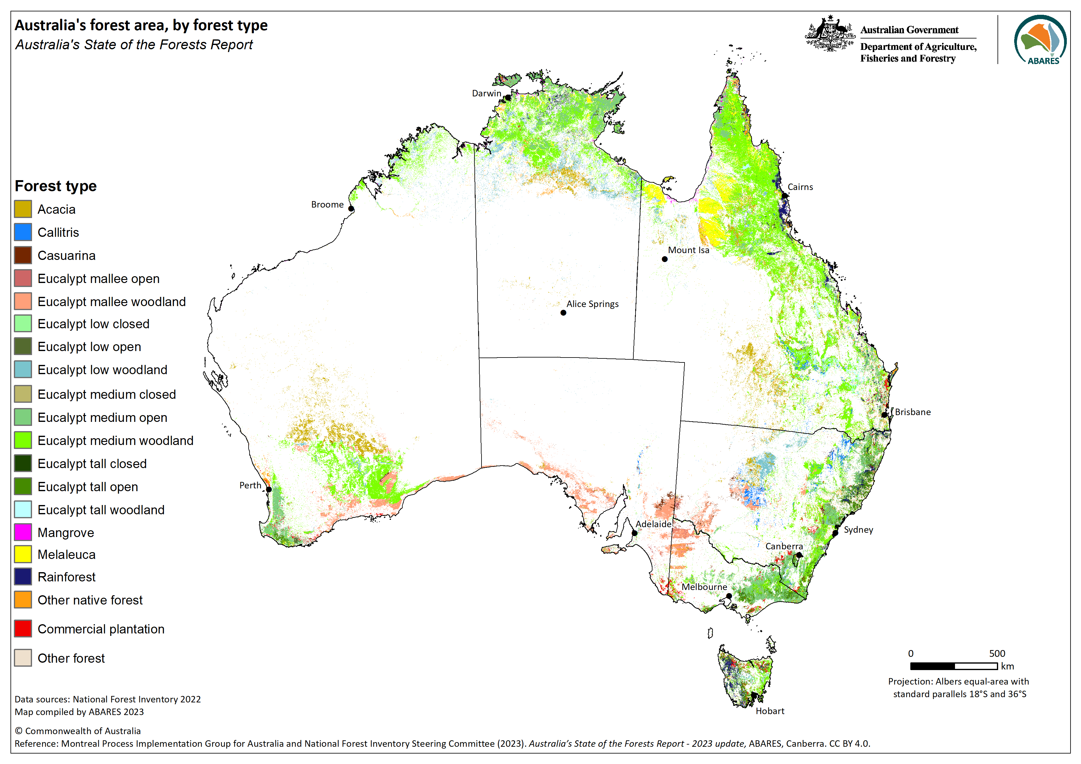
Forests of Australia (2023) is a continental spatial dataset of forest extent, by national forest categories and types, assembled for the 2023 update of Indicator 1.1a for Australia's State of the Forests Report. It was developed from multiple forest, vegetation and land cover data inputs, including contributions from Australian, state and territory government agencies and external sources.
A forest is defined in this dataset as:
An area, incorporating all living and non-living components, that is dominated by trees having usually a single stem and a mature or potentially mature stand height exceeding two metres and with existing or potential crown cover of overstorey strata about equal to or greater than 20 per cent. This includes Australia's diverse native forests and commercial plantations, regardless of age. It is also sufficiently broad to encompass areas of trees that are sometimes described as woodlands.
The dataset was compiled by the Australian Bureau of Agricultural and Resource Economics and Sciences (ABARES) for the National Forest Inventory (NFI), a collaborative partnership between the Australian and state and territory governments. The role of the NFI is to collate, integrate and communicate information on Australia's forests. States and territories agencies collect forest data using independent methods and at varying scales or resolutions. The NFI applies a national classification to state and territory data to allow seamless integration of these datasets. Multiple independent sources of external data are used to fill data gaps and improve the quality of the final dataset.
The NFI classifies forests into three national forest categories (Native forest, Commercial plantation, and Other forest) and then into various forest types. Commercial plantations presented in this dataset were sourced from the National Plantation Inventory (NPI) Australia's plantations 2020-21 spatial dataset, also produced by ABARES. Another dataset produced by ABARES, the Catchment scale Land Use and Management (CLUM) dataset (2020) was used to identify and mask out land uses that are inappropriate to map as forest.
The Forests of Australia (2023) dataset is produced to fulfil requirements of the Australia's National Forest Policy Statement (NFPS) and the Regional Forests Agreement Act 2002 (Cwth), and is used by the Australian Government for domestic and international reporting.
Data
Forests of Australia (2023) – Esri Grid (raster), layer file and metadata documents (zipped) [71 MB]
Forests of Australia (2023) – GeoTIFF (raster), layer file and metadata documents (zipped) [71 MB]
Forests of Australia (2023) – CSV, attribute data only [45 KB]
Lineage details PDF [243 KB]
Attributes and Lookup tables PDF [364 KB]
Metadata PDF [443 KB]
Web services/Interactive map viewer
Graphic
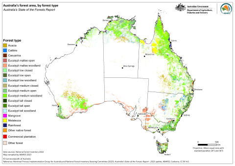
Forests of Australia (2023) – Australia's forest cover and forest type distribution – graphic only – PNG [735 KB]
Superseded datasets
Publication date: 16 February 2019
Forests of Australia (2018) is a continental spatial dataset of forest extent, by national forest categories and types, assembled for Australia's State of the Forests Report 2018. It was developed from multiple forest, vegetation and land cover data inputs, including contributions from Australian, state and territory government agencies and external sources.
A forest is defined in this dataset as:
An area, incorporating all living and non-living components, that is dominated by trees having usually a single stem and a mature or potentially mature stand height exceeding two metres and with existing or potential crown cover of overstorey strata about equal to or greater than 20 per cent. This includes Australia's diverse native forests and commercial plantations, regardless of age. It is also sufficiently broad to encompass areas of trees that are sometimes described as woodlands.
The dataset was compiled by the Australian Bureau of Agricultural and Resource Economics and Sciences (ABARES) for the National Forest Inventory (NFI), a collaborative partnership between the Australian and state and territory governments. The role of the NFI is to collate, integrate and communicate information on Australia's forests. States and territories agencies collect forest data using independent methods and at varying scales or resolutions. The NFI applies a national classification to state and territory data to allow seamless integration of these datasets. Multiple independent sources of external data are used to fill data gaps and improve the quality of the final dataset.
The NFI classifies forests into three national forest categories (Native forest, Commercial plantation, and Other forest) and then into various forest types. Commercial plantations presented in this dataset were sourced from the National Plantation Inventory (NPI) spatial dataset (2016), also produced by ABARES. Another dataset produced by ABARES, the Catchment scale Land Use and Management (CLUM) dataset (2016) was used to identify and mask out land uses that are inappropriate to map as forest.
The Forests of Australia (2018) dataset is produced to fulfil requirements of the Australia's National Forest Policy Statement (NFPS) and the Regional Forests Agreement (RFA) Act 2002 (Cwth), and is used by the Australian Government for domestic and international reporting.
Data
Forests of Australia (2018) – Esri Grid (raster), layer file and metadata documents (zipped) – [64 MB]
Forests of Australia (2018) – GeoTIFF (raster), layer file and metadata documents (zipped) – [64 MB]
Lineage details PDF [498 KB]
Attributes and Lookup tables PDF [506 KB]
Metadata PDF [603 KB]
Graphic
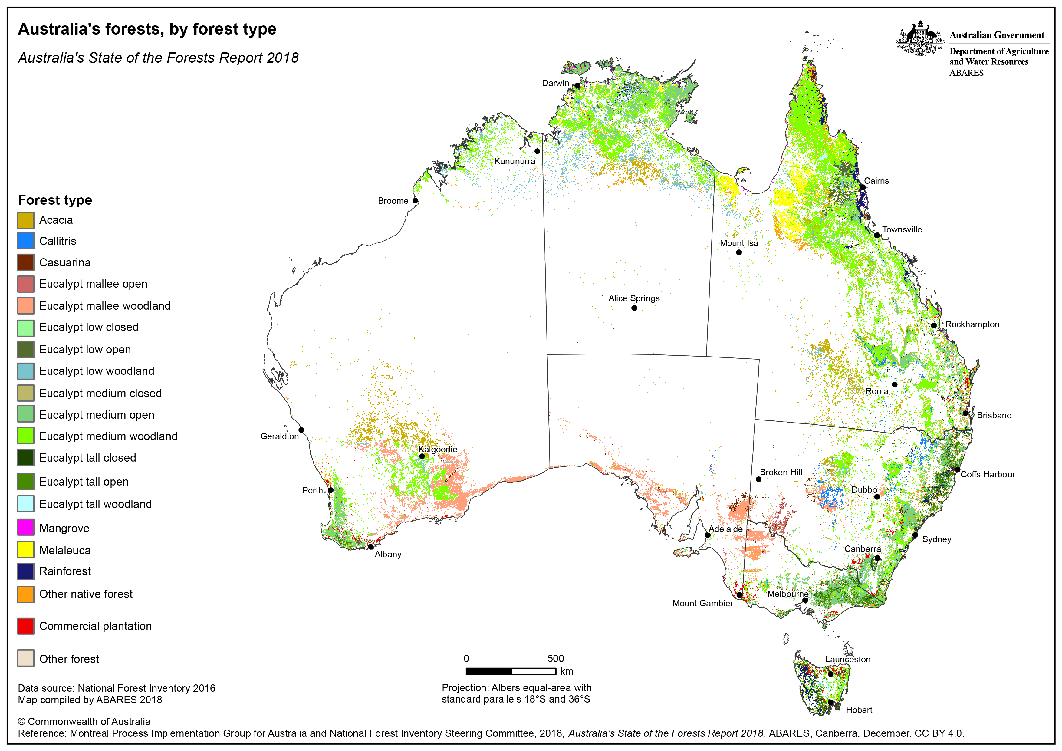
Forests of Australia (2018) – Australia's forest cover and forest type distribution – graphic only – PNG: [1.1 MB] – PDF: [3.5 MB]
Interactive map viewer
View an interactive ArcGIS Online map viewer version of this dataset here.
Web service and metadata for the Forests of Australia (2018) dataset.