
Publication date: 28 October 2024
Fires in Australia’s Forests 2016–21 (2024) is a continental spatial dataset of the extent and frequency of planned and unplanned fires occurring in forest in the five financial years between July 2016 and June 2021, assembled for Australia's State of the Forests Report Indicator 3.1b Area of forest burnt by planned and unplanned fire. It was developed from multiple fire area datasets contributed by state and territory government agencies, after consultation with Australia’s Forest Fire Management Group. The fire dataset is then combined with forest cover information sourced from the Forests of Australia (2023) dataset, and forest tenure information sourced from the Tenure of Australia’s Forests (2023) dataset.
Planned fire: Fire started in accordance with a fire management plan or planned burning program, such as fuel-reduction burning or prescribed burning.
Unplanned fire: Fire started naturally (such as by lightning), accidentally, or deliberately (such as by arson), but not in accordance with planned fire management prescriptions. Also called bushfire or wildfire.
The dataset was compiled by the Australian Bureau of Agricultural and Resource Economics and Sciences (ABARES) for the National Forest Inventory (NFI), a collaborative partnership between the Australian and state and territory governments. The role of the NFI is to collate, integrate and communicate information on Australia's forests. The NFI applies a national classification to state and territory data to allow seamless integration of these datasets. Multiple independent sources of external data are used to fill data gaps and improve the quality of the final dataset.
Forest areas burnt by fire are allocated by the month of the fire to a financial year (July–June inclusive). Where more than one fire event occurs on any one hectare during a financial year, only the first fire is recorded for that area in the financial year. Fires are also classified into two categories, planned and unplanned, based on the fire seasonality and advice from state and territory agencies.
The Fires in Australia’s forests 2016–21 (2024) dataset is produced to fulfil requirements of Australia's National Forest Policy Statement and the Regional Forests Agreement Act 2002 (Cwth), and is used by the Australian Government for domestic and international reporting.
Data
Fires in Australia's forests 2016–21 (2024) – Esri Grid (raster), layer files and metadata documents (zipped) [111 MB]
Fires in Australia's forests 2016–21 (2024) – GeoTIFF (raster), layer files and metadata documents (zipped) [106 MB]
Fires in Australia's forests 2016–21 (2024) – CSV, attribute data only [2.8 MB]
Lineage details PDF [336 KB]
Metadata PDF [584 KB]
Web services/Interactive map viewer
Web services and interactive maps of the Fires in Australia’s forests 2016–21 (2024) dataset are hosted by the Digital Atlas of Australia:
Fires in Australia's forest 2016–21 (burn by frequency)
Fires in Australia's forest 2016–21 (burn by fire type, planned/unplanned)
Graphics
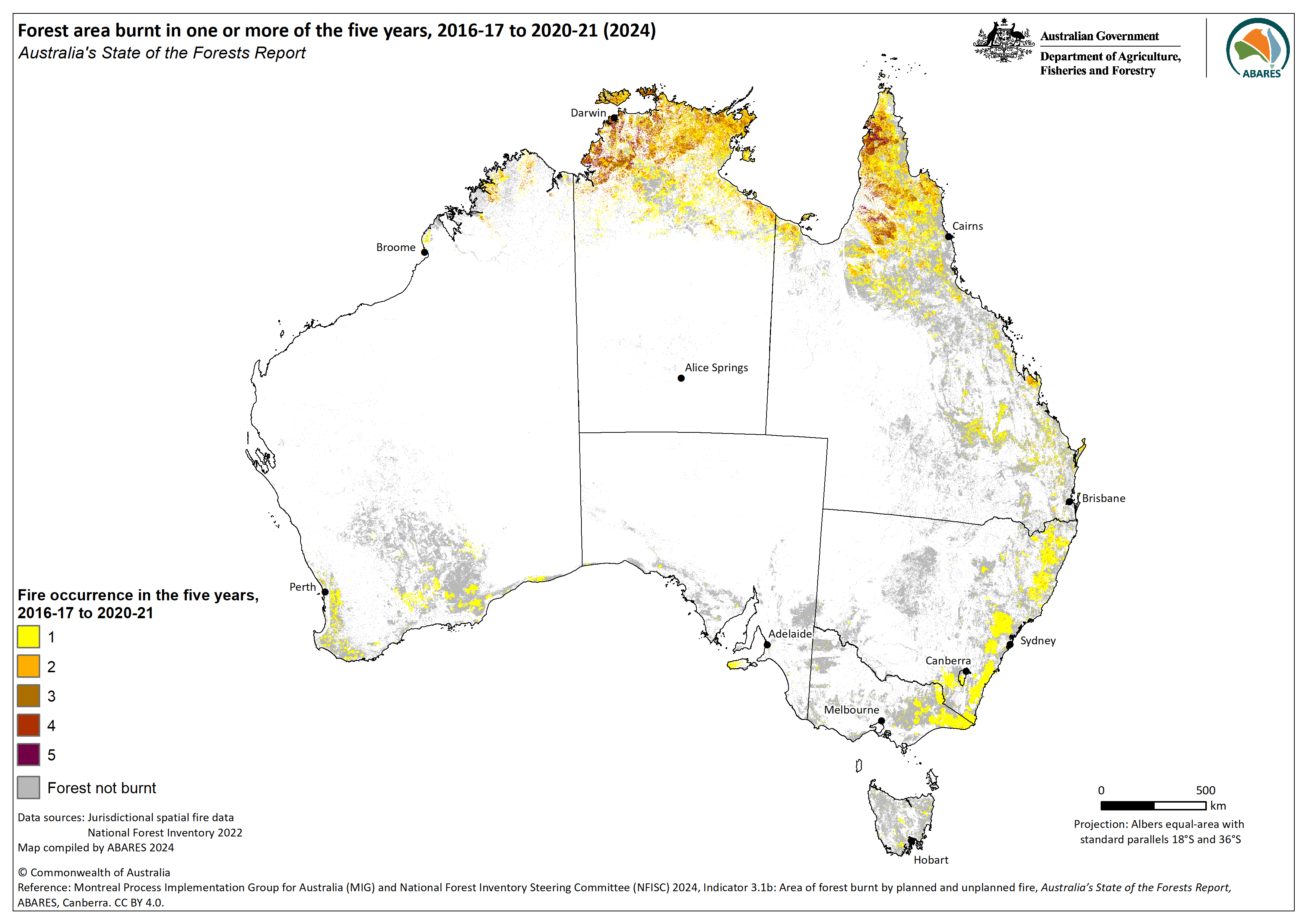
Fires in Australia's forests 2016–21 (2024) – Fire frequency – graphic only – PNG [0.9 MB]
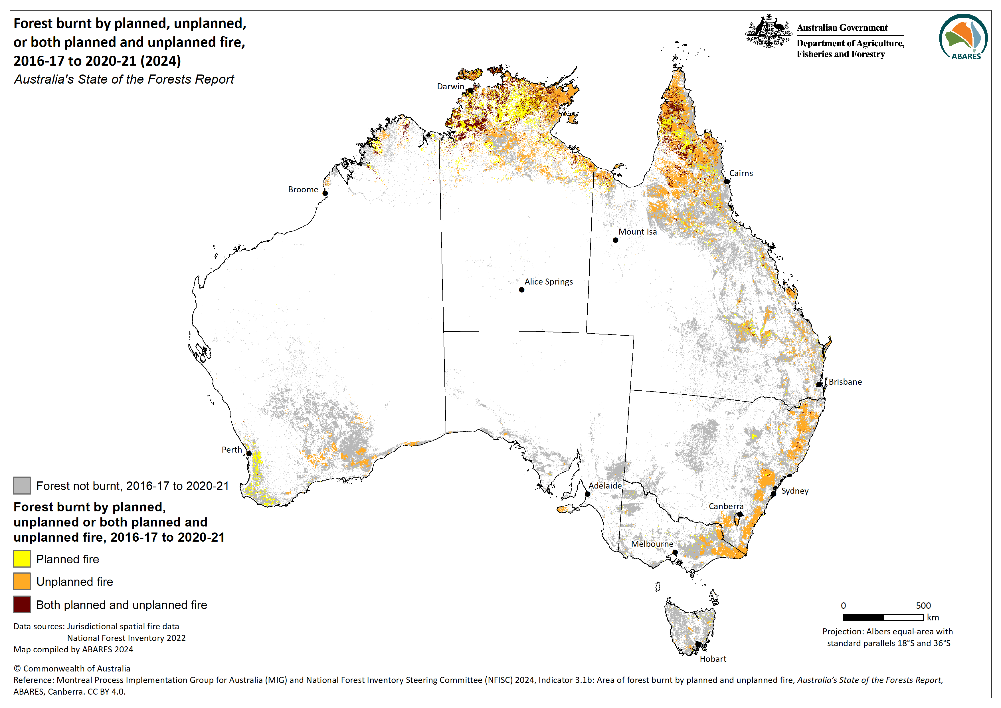
Fires in Australia's forests 2016–21 (2024) – Planned and unplanned fire – graphic only – PNG [1.0 MB]
Superseded datasets
Publication date: 16 February 2019
Fires in Australia’s Forests 2011–16 (2018) is a continental spatial dataset of the extent and frequency of planned and unplanned fires occurring in forest in the five financial years between July 2011 and June 2016, assembled for Australia's State of the Forests Report 2018. It was developed from multiple fire area datasets contributed by state and territory government agencies, after consultation with Australia’s Forest Fire Management Group. The fire dataset is then combined with forest cover information sourced from the Forests of Australia (2018) dataset, and forest tenure information sourced from the Tenure of Australia’s Forests (2018) dataset.
The dataset was compiled by the Australian Bureau of Agricultural and Resource Economics and Sciences (ABARES) for the National Forest Inventory (NFI), a collaborative partnership between the Australian and state and territory governments. The role of the NFI is to collate, integrate and communicate information on Australia's forests. The NFI applies a national classification to state and territory data to allow seamless integration of these datasets. Multiple independent sources of external data are used to fill data gaps and improve the quality of the final dataset.
Forest areas burnt by fire are allocated by the month of the fire to a financial year (July–June inclusive). Where more than one fire event occurs on any one hectare during a financial year, only the first fire is recorded for that area in the financial year. Fires are also classified into two categories, planned and unplanned, based on the fire seasonality and advice from state and territory agencies.
The Fire in Australia’s forests 2011–16 (2018) dataset is produced to fulfil requirements of Australia's National Forest Policy Statement and the Regional Forests Agreement Act 2002 (Cwth), and is used by the Australian Government for domestic and international reporting.
Data
Fires in Australia's forests 2011–16 (2018) – Esri Grids (raster), layer files and metadata documents (zipped) – [99 MB]
Fires in Australia's forests 2011–16 (2018) – GeoTIFF (raster), layer files and metadata documents (zipped) – [77 MB]
Lineage details PDF [775 KB]
Attributes and lookup tables PDF [366 KB]
Metadata PDF [584 KB]
Graphics

Fires in Australia's forests 2011–16 (2018) – Fire frequency – graphic only – PNG: [0.9 MB] – PDF: [2.0 MB]

Fires in Australia's forests 2011–16 (2018) – Planned and unplanned fire – graphic only – PNG: [1.0 MB] – PDF: [2.4 MB]
Interactive map viewer
View an interactive ArcGIS Online map viewer version of this dataset here.
Web service and metadata for the Fires in Australia's forests 2011–16 (2018) dataset.