
Publication date: 15 December 2023
Tenure of Australia’s forests (2023) is a continental spatial dataset of national land tenure types, assembled for Australia's State of the Forests Report – 2023 update. It was developed from land tenure information from multiple sources, including contributions from Australian, state and territory government agencies and external sources. The tenure dataset is then combined with forest cover information sourced from the Forests of Australia (2023) dataset.
The dataset was compiled by the Australian Bureau of Agricultural and Resource Economics and Sciences (ABARES) for the National Forest Inventory (NFI), a collaborative partnership between the Australian and state and territory governments. The role of the NFI is to collate, integrate and communicate information on Australia’s forests. The NFI applies a national classification to state and territory data to allow seamless integration of these datasets. Multiple independent sources of external data are used to fill data gaps and improve the quality of the final dataset.
The NFI classifies land tenure into six national tenure classes suitable for application to forest: Leasehold forest, Multiple-use public forest, Nature conservation reserve, Other Crown land, Private forest and Unresolved tenure.
The Tenure of Australia’s forests (2023) dataset is produced to fulfil requirements of Australia's National Forest Policy Statement and the Regional Forests Agreement Act 2002 (Cwth), and is used by the Australian Government for domestic and international reporting.
Data
Tenure of Australia's forests (2023) – Esri Grid (raster), layer file and metadata documents (zipped) [74 MB]
Tenure of Australia's forests (2023) – GeoTIFF (raster), layer file and metadata documents (zipped) [90 MB]
Tenure of Australia's forests (2023) – CSV, attribute data only [101 KB]
Attributes and lookup tables PDF [590 KB]
Metadata PDF [583 KB]
Graphic
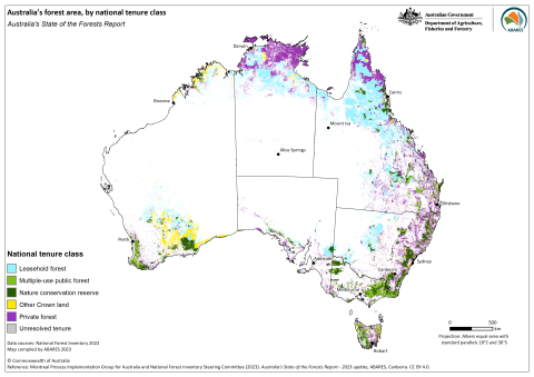
Tenure of Australia's forests (2023) – graphic only – PNG [0.5 MB]
ABARES report on the development of a national tenure dataset for reporting forest tenure
The ABARES technical report Development of a national tenure dataset for reporting the tenure of Australia's forests describes the principles of tenure determination, the past methods of assembling and reporting the tenure of forests. This method was applied to assemble both the Tenure of Australia’s forests (2018) spatial dataset and the current update to the Tenure of Australia’s forests (2023) dataset.
Superseded datasets
Publication date: 16 February 2019
Tenure of Australia’s forests (2018) is a continental spatial dataset of national land tenure types, assembled for Australia's State of the Forests Report 2018. It was developed from land tenure information from multiple sources, including contributions from Australian, state and territory government agencies and external sources. The tenure dataset is then combined with forest cover information sourced from the Forests of Australia (2018) dataset.
The dataset was compiled by the Australian Bureau of Agricultural and Resource Economics and Sciences (ABARES) for the National Forest Inventory (NFI), a collaborative partnership between the Australian and state and territory governments. The role of the NFI is to collate, integrate and communicate information on Australia’s forests. The NFI applies a national classification to state and territory data to allow seamless integration of these datasets. Multiple independent sources of external data are used to fill data gaps and improve the quality of the final dataset.
The NFI classifies land tenure into six national tenure classes suitable for application to forest: Leasehold forest, Multiple-use public forest, Nature conservation reserve, Other Crown land, Private forest and Unresolved tenure.
The Tenure of Australia’s forests (2018) dataset is produced to fulfil requirements of Australia's National Forest Policy Statement and the Regional Forests Agreement Act 2002 (Cwth), and is used by the Australian Government for domestic and international reporting.
Data
Tenure of Australia's forests (2018) – Esri Grid (raster), layer file and metadata documents (zipped) – [74 MB]
Tenure of Australia's forests (2018) – GeoTIFF (raster), layer file and metadata documents (zipped) – [90 MB]
Lineage details PDF [834 KB]
Attributes and lookup tables PDF [590 KB]
Metadata PDF [583 KB]
Graphic
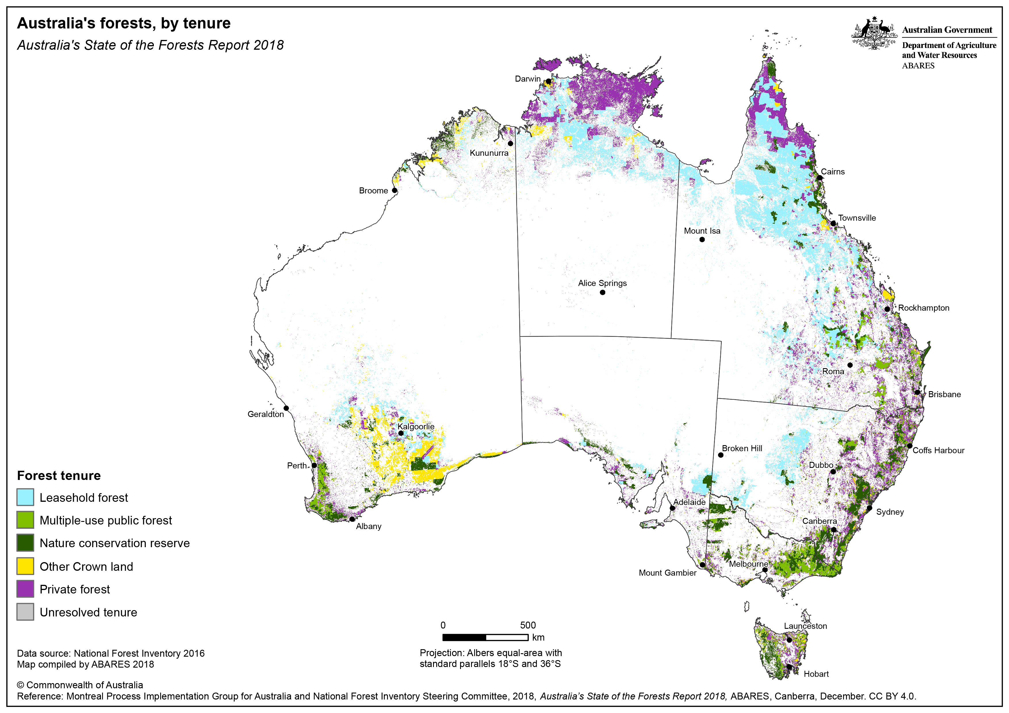
Tenure of Australia's forests (2018) – graphic only – PNG: [0.9 MB] – PDF: [3.5 MB]
Interactive map viewer
View an interactive ArcGIS Online map viewer version of this dataset here.
Web service and metadata for the Tenure of Australia's forests (2018) dataset.