
Publication date: 19 March 2019
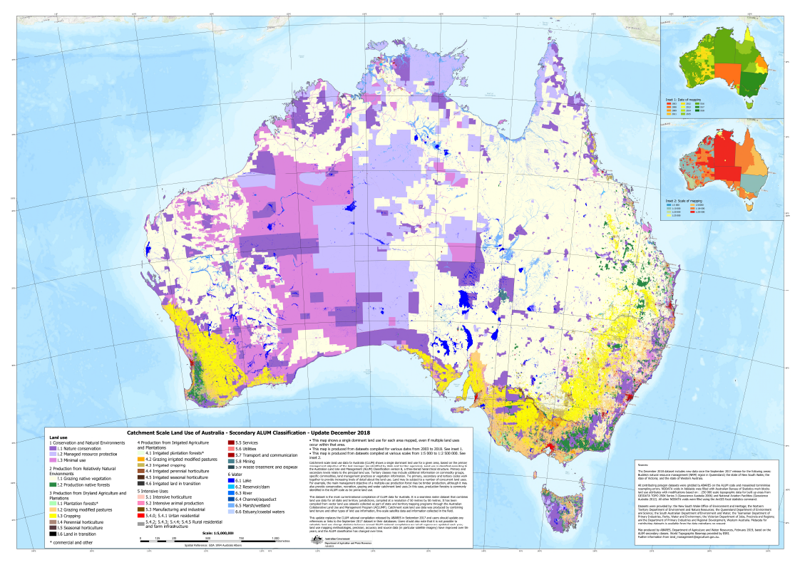
This dataset is the most current national compilation of catchment scale land use data for Australia (CLUM), as at December 2018. It replaces the Catchment Scale Land Use of Australia – Update September 2017. It is a seamless raster dataset that combines land use data for all state and territory jurisdictions, compiled at a resolution of 50 metres by 50 metres. It has been compiled from vector land use datasets collected as part of state and territory mapping programs through the Australian Collaborative Land Use and Management Program (ACLUMP). Catchment scale land use data was produced by combining land tenure and other types of land use information, fine-scale satellite data and information collected in the field. The date of mapping (2003 to 2018) and scale of mapping (1:5 000 to 1:250 000) vary, reflecting the source data, capture date and scale. This information is provided in a supporting polygon dataset.
The following areas have been updated since the September 2017 version: Burdekin natural resource management (NRM) region in Queensland; the state of New South Wales; the state of Victoria; and the state of Western Australia.
The CLUM data shows a single dominant land use for a given area, based on the primary management objective of the land manager (as identified by state and territory agencies). Land use is classified according to the Australian Land Use and Management (ALUM) Classification version 8, a three-tiered hierarchical structure. There are five primary classes, identified in order of increasing levels of intervention or potential impact on the natural landscape. Water is included separately as a sixth primary class. Primary and secondary levels relate to the principal land use. Tertiary classes may include additional information on commodity groups, specific commodities, land management practices or vegetation information.
The Catchment Scale Land Use of Australia – Update December 2018 is a product of the Australian Collaborative Land Use and Management Program (ACLUMP). ACLUMP, a consortium of Australian, state and territory government partners, promotes the development of nationally consistent information on land use and land management practices underpinned by common technical standards.
A complementary dataset Catchment Scale Land Use of Australia – Commodities – Update December 2018 provides commodity level mapping as a vector dataset.
Downloads
Data
Catchment Scale Land Use of Australia - raster package (GeoTIFF format) - ZIP [485 MB]
Catchment Scale Land Use of Australia - currency shapefile package (ESRI shapefile) - ZIP [191 MB]
Catchment Scale Land Use of Australia - metadata (MS Word) - MS Word [1 MB]
Catchment Scale Land Use of Australia - metadata (PDF) - PDF [443 KB]
Description of contents of the data package (MS Word) - MS Word [23 KB]
Description of contents of the data package (PDF) - PDF [685 KB]
General Downloads
Catchment Scale Land Use of Australia - Map showing the year of CLUM mapping (PDF) - PDF [226 KB]
Catchment Scale Land Use of Australia - Map showing scale of CLUM mapping (PDF) - PDF [311 KB]