Skip to main content Skip to main navigation Skip to search
ABARES - Land use and management

Top navigation abares

  • Department
  • Ministers
  • Media Centre
Main menu

Main navigation ACLUMP

  • Land home
    Land home
  • About ACLUMP
    About ACLUMP
  • Land use
    Land use
  • Publications
    Publications
  • Data download
    Data download
  • Latest news
    Latest news
Department of Agriculture

Breadcrumb

  1. DAFF Home
  2. ABARES
  3. Land use and management
  4. Multi-Criteria Analysis Shell for Spatial Decision Support
  5. Quick Start Guide
  6. 5. Building Criteria

Secondary ACLUMP

  • Quick Start Guide
    • 1. Introduction
    • 2. Set Up
    • 3. Input and Classification
    • 4. Composition and Comparison
    • 5. Building Criteria
    • 6. Reporting and Analysis
    • 7. Exporting

Building Criteria

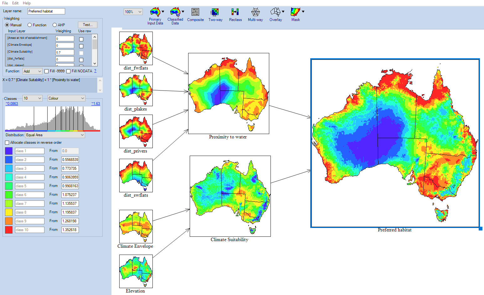
Next, we need to combine the "Climate suitability" and "Proximity to water" map layers to find the regions of Australia which best fit the preferred habitat of the example species. This can be achieved using a manually weighted composite.

  1. Click and drag a new composite onto the workspace.
  2. Rename it to "Preferred habitat"
  3. Ensure that "Manual" weighting is selected.
  4. Find "Climate suitability" and "Proximity to water" in the scrollable list below the weighting type buttons.
  5. Apply a weighting of "0.7" to "Climate suitability" by inputting "0.7" into its weighting field.
  6. Similarly, apply a weighting of "1" to "Proximity to water".
  7. Select 10 classes from the "Classes" drop down menu.
  8. Select an "Equal Area" distribution.

MCAS QS pref habitat.png

Mouse over any of the map layers to see information about the layer at the location of the cursor in the Viewer window. If the viewer is not present, go to Edit → Show Viewer Window in the top menu.

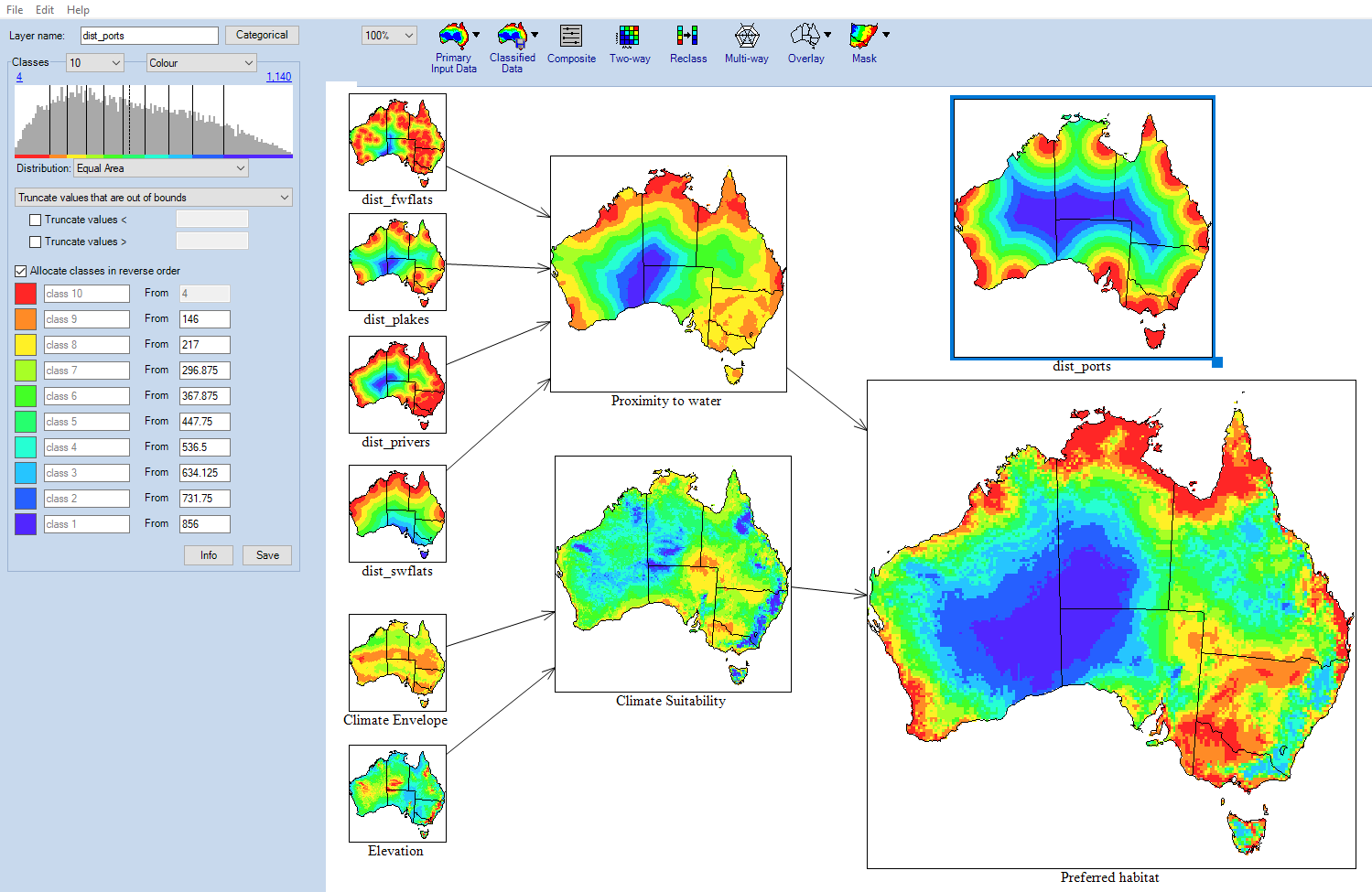
Finding Areas at Risk of Establishment

The primary method of entry into Australia of the species is through ports. Armed with this fact, we can discern locations where the species is most likely to appear and successfully gain a foothold by matching the locations of ports to the previously generated suitable habitat data.

  1. Click on Primary Data. Open the Infrastructure folder. Click and drag "Distance to ports" onto the workspace. This brings in a distance to ports dataset.
  2. Classify this layer into 10 classes
  3. Select "Equal area" from the distribution drop down.

MCAS QS 5 dist ports.png

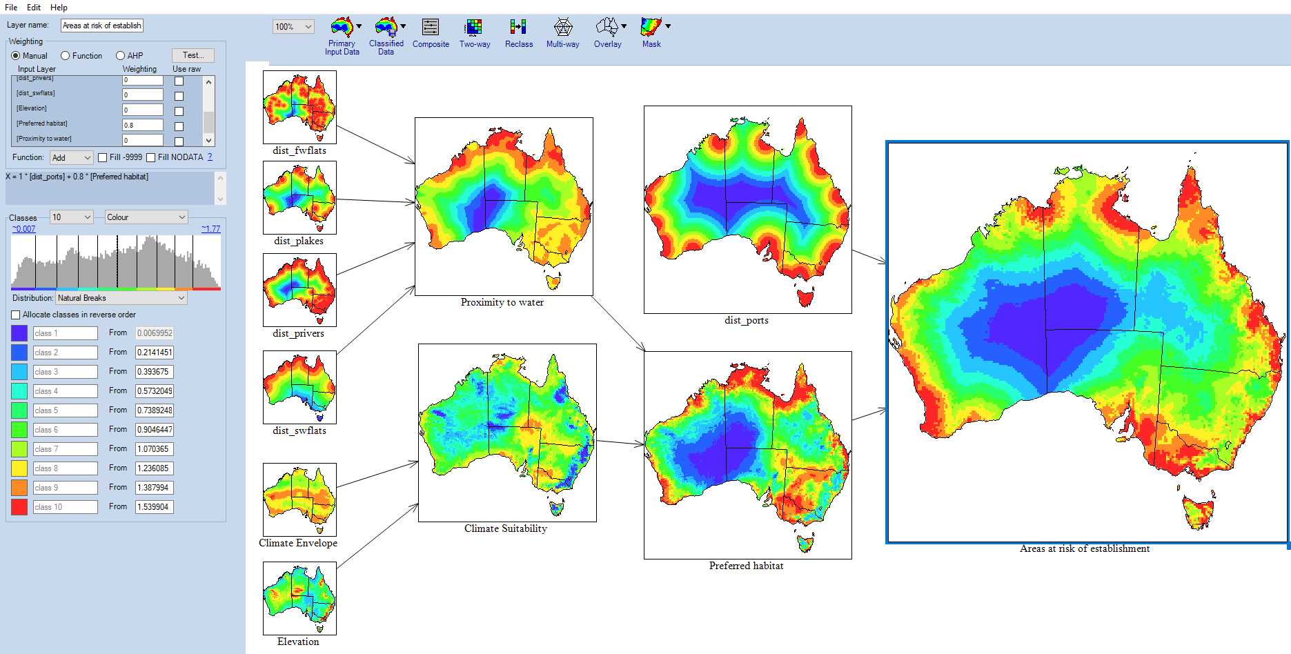
Now to create the composition "Areas at risk of establishment".

  1. Drag a new composite onto the workspace and rename it to "Areas at risk of establishment"
  2. Apply a manual weighting of "1" for "distance to ports" and "0.8" to "Preferred habitat".
  3. Select "Natural Breaks" from the distribution drop down menu.

MCAS QS establishment risk.png

← Previous Section: Compostition and Comparison  |  Next Section: Reporting and Analysis →​

Contents

  1. Introduction
  2. Set Up
  3. Input and Classification
  4. Composition and Comparison
  5. Building Criteria
  6. Reporting and Analysis
  7. Exporting
Thanks for your feedback.
Thanks! Your feedback has been submitted.

We aren't able to respond to your individual comments or questions.
To contact us directly phone us or submit an online inquiry

CAPTCHA
This question is for testing whether or not you are a human visitor and to prevent automated spam submissions.

Please verify that you are not a robot.

Skip
Page last updated: 13 October 2021

We acknowledge the continuous connection of First Nations Traditional Owners and Custodians to the lands, seas and waters of Australia. We recognise their care for and cultivation of Country. We pay respect to Elders past and present, and recognise their knowledge and contribution to the productivity, innovation and sustainability of Australia’s agriculture, fisheries and forestry industries.

Artwork: Protecting our Country, Growing our Future
© Amy Allerton, contemporary Aboriginal Artist of the Gumbaynggirr, Bundjalung and Gamilaroi nations.

Footer

  • Contact us
  • Accessibility
  • Disclaimer
  • Privacy
  • FOI

© Department of Agriculture, Fisheries and Forestry

Facebook X LinkedIn Instagram