
Steps to export a data layer
- Select the layer you wish to export
- Right click on the layer and select Export. An Export Classified Data window will appear;
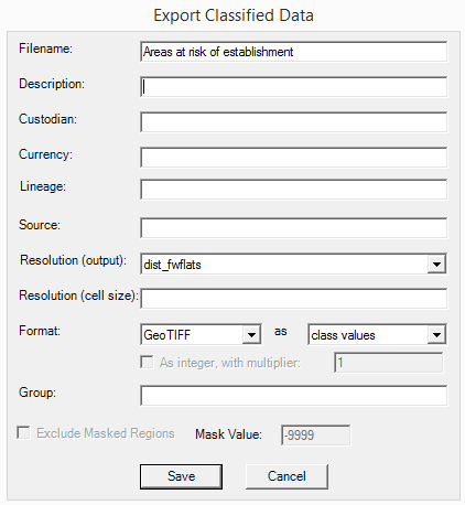
- Choose a simple new filename and enter other metadata details such as: a detailed description including any units, custodian, currency, lineage (what has been done to produce the layer), and data source to assist yourself and other users to understand this data layer and how to use it correctly.
- Set the resolution to an existing layer,
- Select the format: Layers can be exported as a GeoTIFF or ASCII file. Note that MCAS-S only reads exported files as GeoTIFFs, thus ASCII formatted files should only be used for other applications.
- Select to save using Continuous (flexible) or Class (fixed) values
- Class values are fixed. The layer will be saved with the current number of classes and colours, which cannot be changed when brought back into MACS-S.
- Continuous values can be reclassified. If a layer is saved using 'continuous values', the layer will behave like a primary data layer when brought back into MCAS-S, meaning that colours and classes can be reclassified. You may wish to reduce the size of your new continuous layer by removing decimal points to export the layer as an integer:
- Choose whether to export the data layer as an integer (to remove decimal places and reduce the size of the exported layer) by checking the "As integer" box, or retain decimal values by unchecking. To retain a smaller integer output without losing the precision of the original data layer apply a multiplier. For example applying a multiplier of 10 will multiply the value of every pixel by 10 turning 0.1 into 1 thus preserving the values from one decimal place while creating a smaller integer data layer.
- Choose where to save: You may save the exported layer into a new or existing group folder under Classified Data by typing the folder name into the Group field or leave the field blank to save directly in the Classified folder. Exporting layers to specific groups/folders may be useful for ordering large numbers of derived data layers that can be structured according to project needs.
- Choose whether to exclude masked regions: If you have a mask applied which is restricting the view only range you can choose whether to exclude areas outside of your current view. In order to do this you may wish to assign the no-data value (default) -9999. Assigning -9999 to masked areas means that when the layer is unmasked those areas will display as hatched grey and you will need to decide how these areas should be included in any future analysis. If there is another value that is more appropriate for your masked areas, simply type this into the Mask Value field.
- Click save. Your layer is now saved under the Classified Data folder. To bring it into the workspace open the Classified folder or the Group folder that you selected under the classified folder and drag the layer in to the workspace.