Skip to main content Skip to main navigation Skip to search
forestsaustralia

Help us improve our website

We want to hear from you!

Please share with us your experience using the Forests Australia website to access forest-related data and information. You can help us better understand your needs, what works now, and what could be improved.

Take our quick survey

end link

ABARES - Forests Australia

Top navigation abares

  • Department
  • Ministers
  • Media Centre
Main menu

Main navigation Forests Australia

  • Home
    Home
  • Australia’s forests
    Australia’s forests
  • State of the forests reports
    State of the forests reports
  • Product statistics
    Product statistics
  • Plantation statistics
    Plantation statistics
  • Data and maps
    Data and maps
Department of Agriculture

Breadcrumb

  1. DAFF Home
  2. ABARES
  3. Forests Australia
  4. Data, maps and tools
  5. Forest spatial data
  6. National Plantation Inventory regions boundaries

Secondary Forests Australia

  • Spatial data
    • Forests of Australia
    • Tenure of Australia's forests
    • Australia's Indigenous land and forest estate
    • Fires in Australia's forests
    • Regional Forestry Hubs boundaries
    • Australia's plantations
    • National Plantation Inventory region boundaries

National Plantation Inventory regions boundaries

Publication date: 11 June 2026

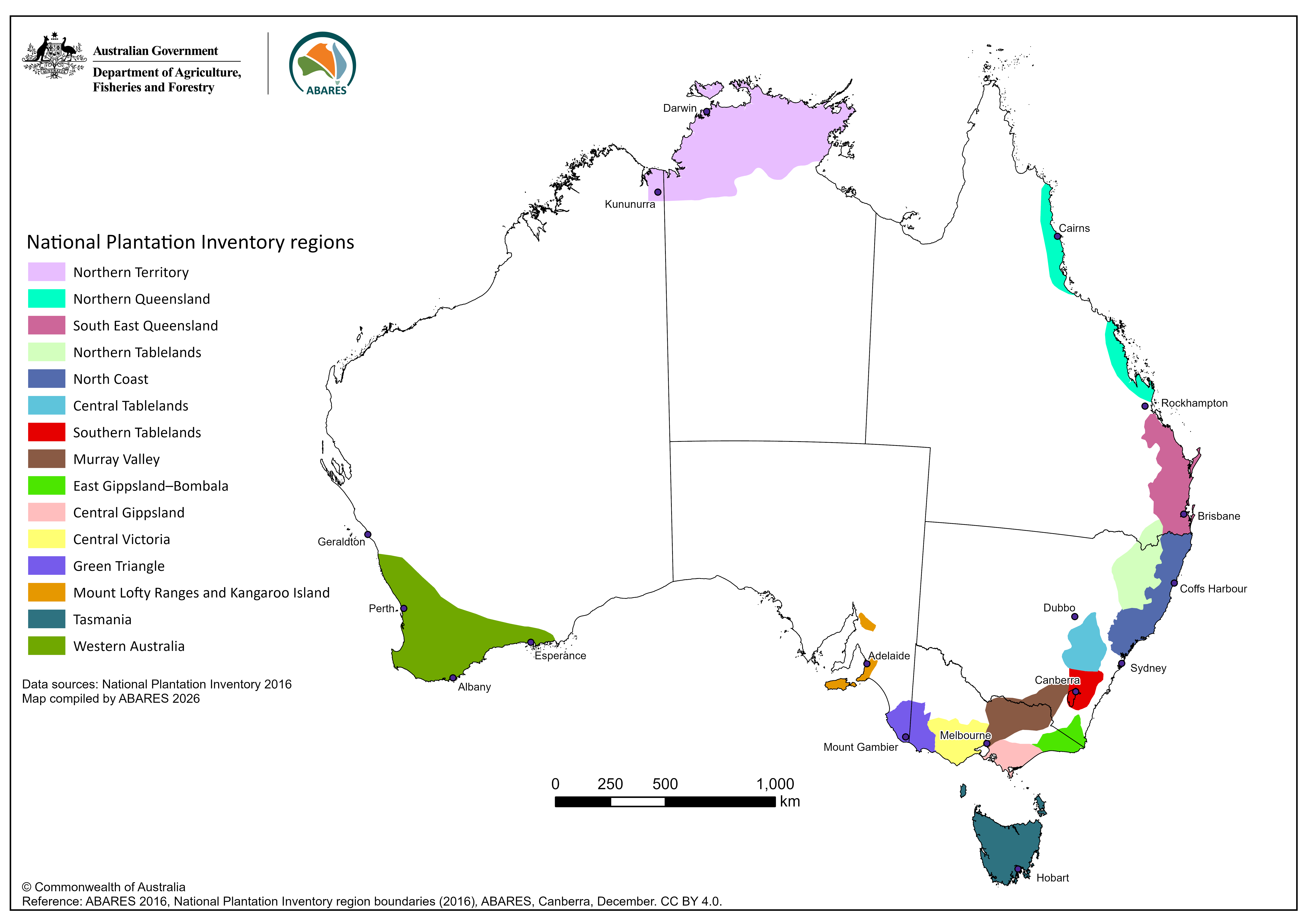
The National Plantation Inventory regions boundaries (2016) dataset comprises the spatial boundaries of the 15 National Plantation Inventory (NPI) regions for Australia. The NPI is a component of the National Forest Inventory (NFI), managed by ABARES.

The National Plantation Inventory (NPI) regions were established in 1995 to facilitate national reporting on Australia’s commercial (industrial) plantation estate. The boundaries were developed in consultation with the NPI Reference Committee which consisted largely of grower and industry representatives. The first compilation of spatial data for commercial plantations, by NPI regions, was completed in 1996 with the first map-based report published in 1997.

The 15 NPI regions were largely based on the extant plantation estate and represent economic wood supply zones. Wood flows are not constrained by political borders, and thus six regions span state or territory borders: Northern Tablelands (New South Wales/Queensland); Southern Tablelands (Australian Capital Territory/New South Wales); Murray Valley (New South Wales/Victoria); East Gippsland/Bombala (Victoria/New South Wales); Green Triangle (Victoria/South Australia); and Northern Territory (Northern Territory/Western Australia).

The NPI regions were designed to capture most of the plantation estate. However, commercial and farm forestry plantations can occur outside the currently defined NPI regions, in accordance with landholder decision making.

The National Plantation Inventory regions boundaries dataset is used by the Australian Government for domestic reporting.

Data

National Plantation Inventory regions boundaries (2016) – Shapefiles and metadata​ (zipped)​ – [1.6MB]

National Plantation Inventory regions boundaries (2016) – Metadata – PDF [0.5MB]​​

National Plantation Inventory regions boundaries (2016) – Metadata – Word [1.2MB]​​

Graphics

National Plantation Inventory regions map

Map of Australia showing National Plantation Inventory regions with distinct colours representing the different regions.

National Plantation Inventory regions map – graphic only – PNG [1.2 MB]

Thanks for your feedback.
Thanks! Your feedback has been submitted.

We aren't able to respond to your individual comments or questions.
To contact us directly phone us or submit an online inquiry

CAPTCHA
This question is for testing whether or not you are a human visitor and to prevent automated spam submissions.

Please verify that you are not a robot.

Skip
Page last updated: 11 June 2026

We acknowledge the continuous connection of First Nations Traditional Owners and Custodians to the lands, seas and waters of Australia. We recognise their care for and cultivation of Country. We pay respect to Elders past and present, and recognise their knowledge and contribution to the productivity, innovation and sustainability of Australia’s agriculture, fisheries and forestry industries.

Artwork: Protecting our Country, Growing our Future
© Amy Allerton, contemporary Aboriginal Artist of the Gumbaynggirr, Bundjalung and Gamilaroi nations.

Footer

  • Contact us
  • Accessibility
  • Disclaimer
  • Privacy
  • FOI

© Department of Agriculture, Fisheries and Forestry

Facebook X LinkedIn Instagram