Skip to main content Skip to main navigation Skip to search
ABARES - Land use and management

Top navigation abares

  • Department
  • Ministers
  • Media Centre
Main menu

Main navigation ACLUMP

  • Land home
    Land home
  • About ACLUMP
    About ACLUMP
  • Land use
    Land use
  • Publications
    Publications
  • Data download
    Data download
  • Latest news
    Latest news
Department of Agriculture

Breadcrumb

  1. DAFF Home
  2. ABARES
  3. Land use and management
  4. Land Cover

Secondary ACLUMP

  • ACLUMP
    • About ACLUMP
    • Latest news
    • Land data and maps
    • Land use
      • Land use mapping
      • Catchment scale land use of Australia and Commodities – Update December 2023
      • Catchment scale land use profiles
      • Mapping technical specifications
      • Land use apps
      • Data download
      • Publications
      • Australian Land Use and Management Classification
        • ALUM Classification Version 8 (October 2016)
      • Australian Agricultural Census 2020–21 visualisations
      • Land use of Australia 2010–11 to 2020–21
    • Land Management Practices
      • Collating LMP Information
      • Data and Maps
      • Drivers for LMP Information
      • Information System
      • Mapping ground cover management
      • Publications
    • Land tenure
      • Land tenure of Australia 2010–11 to 2020–21
    • Land Cover
      • Dynamic land cover
      • Ground cover monitoring for Australia
      • Ground cover indicator for drought resilience
      • Publications
    • Land Use Change Overview
      • Catchment scale examples
      • National scale examples
    • Publications
    • Definitions
    • Multi-Criteria Analysis Shell for Spatial Decision Support
      • MCAS-S tool
      • MCAS-S user guide
      • Australian national map layers
      • Quick Start Guide
        • 1. Introduction
        • 2. Set Up
        • 3. Input and Classification
        • 4. Composition and Comparison
        • 5. Building Criteria
        • 6. Reporting and Analysis
        • 7. Exporting
      • Preparing your own data
      • Updates
      • Disclaimer
      • MCAS-S-version-4

Land Cover

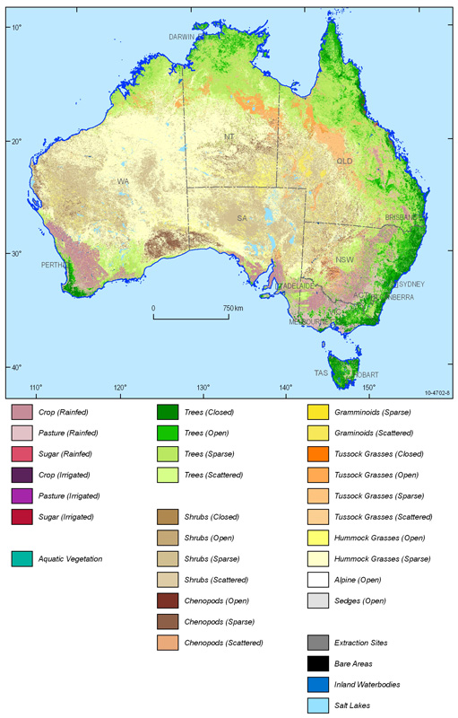
​Land cover is the observed biophysical cover on the Earth's surface. This includes native vegetation, soils, exposed rocks and water bodies as well as anthropogenic elements such as plantations, crops and built environments. The capacity to measure and report change and trend in land and ground cover over time is critical.

A national land cover information dataset has been developed by Geoscience Australia and the Australian Bureau of Agricultural and Resource Economics and Sciences (ABARES) in partnership with state and territory agencies. It comprises a National Dynamic Land Cover Dataset (DLCD) for Australia, a series of derived mapping products and technical information. The products are located on Geoscience Australia's website and will be available late 2011.

ground cover.jpg 

​Links

Dynamic land cover

Ground cover monitoring for Australia

Geoscience Australia

Publications

Thanks for your feedback.
Thanks! Your feedback has been submitted.

We aren't able to respond to your individual comments or questions.
To contact us directly phone us or submit an online inquiry

CAPTCHA
This question is for testing whether or not you are a human visitor and to prevent automated spam submissions.

Please verify that you are not a robot.

Skip
Page last updated: 13 October 2021

We acknowledge the continuous connection of First Nations Traditional Owners and Custodians to the lands, seas and waters of Australia. We recognise their care for and cultivation of Country. We pay respect to Elders past and present, and recognise their knowledge and contribution to the productivity, innovation and sustainability of Australia’s agriculture, fisheries and forestry industries.

Artwork: Protecting our Country, Growing our Future
© Amy Allerton, contemporary Aboriginal Artist of the Gumbaynggirr, Bundjalung and Gamilaroi nations.

Footer

  • Contact us
  • Accessibility
  • Disclaimer
  • Privacy
  • FOI

© Department of Agriculture, Fisheries and Forestry

Facebook X LinkedIn Instagram