Skip to main content Skip to main navigation Skip to search
ABARES - Forests Australia

Top navigation abares

  • Department
  • Ministers
  • Media Centre
Main menu

Main navigation Forests Australia

  • Home
    Home
  • Australia’s forests
    Australia’s forests
  • State of the forests reports
    State of the forests reports
  • Product statistics
    Product statistics
  • Plantation statistics
    Plantation statistics
  • Data and maps
    Data and maps
  • Publications
    Publications
Department of Agriculture

Breadcrumb

  1. DAFF Home
  2. ABARES
  3. Forests Australia
  4. Mangrove forest

Secondary Forests Australia

  • Forests Australia
    • Australia's forests
      • Forest profiles
        • Australia's forests-overview
        • Acacia forest
        • Callitris forest
        • Casuarina forest
        • Eucalypt forest
        • Mangrove forest
        • Melaleuca forest
        • Rainforest
        • Commercial plantations
    • Fast forest facts
    • Australia's State of the Forests Report
      • Australia's State of the Forests Report 2018
        • Executive summary
          • Data
        • Criterion 1
        • Criterion 2
        • Criterion 3
        • Criterion 4
        • Criterion 5
        • Criterion 6
        • Criterion 7
        • Maps and other graphics
        • Data
      • Australia's State of the Forests Report 2013
      • Australia's State of the Forests Report 2008
      • Australia's State of the Forests Report 2003
      • Australia's State of the Forests Report 1998
      • Mandates and drivers for Australia's State of the Forests Report
      • Benefits of producing Australia's State of the Forests Reports
    • Criteria and Indicators for reporting
      • Alignment of Australia's indicators with Montreal Process indicators
      • Review
    • National Forest Inventory
      • National Forest Inventory Steering Committee
    • Forests, land and Australia’s Indigenous peoples
    • Forest and wood products statistics
    • Plantation inventory and statistics
    • Data, maps and tools
      • Data by topic
        • Area of forest
        • Australia's State of the Forests Report
        • Fire
        • Indigenous land and forest
        • Native forests
        • Plantations
        • Regional Forest Agreements
        • Regional forestry profiles
        • Regional Forestry Hubs boundaries
        • Species and ecological communities
        • Tenure of forests
        • Wood products statistics
      • Spatial data
        • Forests of Australia
        • Tenure of Australia's forests
        • Australia's Indigenous land and forest estate
        • Fires in Australia's forests 2011-16
        • Regional Forestry Hubs boundaries
        • Australia's plantations
        • Superseded datasets
      • Data visualisations
        • Forestry regional profiles - data visualisation
        • Australia's native forest types - data visualisation
      • Maps
      • Tools
    • Publications
    • Forest agencies and organisations
    • Australia's forests and forestry glossary

Mangrove forest

This profile has been superseded by the 2019 version, which is available here.

View the complete Australian forest profiles series.

Information for this profile is drawn from Australia's State of the Forests Report 2013.

The Mangrove forest type occurs in many of Australia’s coastal regions, but has a total area of only 0.9 million hectares, or less than 1 per cent of Australia’s forest cover. Australian Mangrove forests contain 41 species of mangrove from 19 plant families. More than half of the world’s mangrove species are found in Australia.

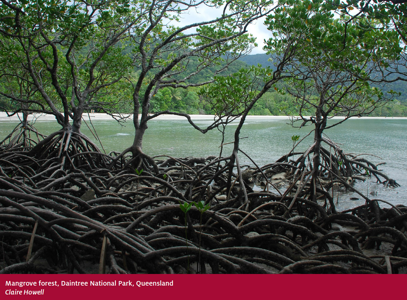
Mangroves are found in the intertidal zones of tropical, subtropical and protected temperate coastal rivers, estuaries and bays, where they grow in fine sediments deposited by rivers and tides.

Mangrove trees have a characteristic growth form, including aerial structural roots and exposed breathing roots. This helps them cope with regular tidal inundation and a lack of oxygen in the soil.

Distribution and ownership

The Mangrove forest type is found in all mainland states and the Northern Territory (Map 1). A total of 0.4 million hectares (48 per cent) are found in Queensland and 0.3 million hectares (37 per cent) are in the Northern Territory.


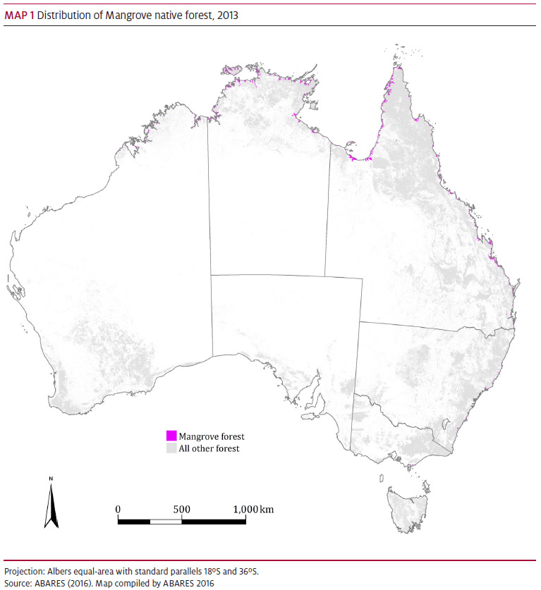
Open a high-resolution version of Map 1 that can be saved as a PNG file

The most common mangrove is white mangrove (Avicennia marina), which is found in mainland coastal areas and comprises three subspecies. Subspecies A. m. marina is found in Western Australia from Bunbury in the south to the Kimberley region in the north. Subspecies A. m. eucalyptifolia is found from Wyndham in northern Western Australia to Mackay in Queensland. Subspecies A. m. australasica is found from south of Rockhampton in central Queensland to Victoria and South Australia.

A total of 0.3 million hectares (34 per cent) of the Mangrove forest type is on private land and 0.2 million hectares (17 per cent) are on other Crown land (Table 1).


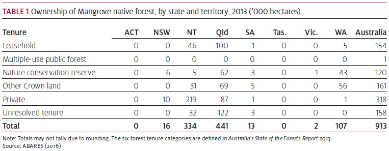
Download Table 1 data as an Excel workbook
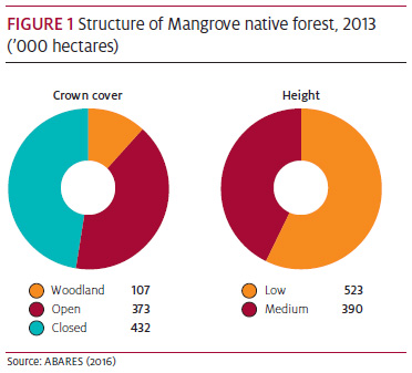
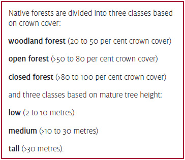
Forest Structure

Forty-seven per cent of Mangrove forest (0.4 million hectares) is closed forest and 57 per cent (0.5 million hectares) is low forest (Figure 1).

Download Figure 1 data as an Excel workbook

Importance and uses

Mangroves contribute many environmental benefits to coastal and estuarine ecosystems. Mangrove tree and root structures prevent erosion by stabilising soils and sediment in intertidal zones, and provide buffer zones from severe storms and cyclones.

Mangroves also provide habitat and food for migratory birds, estuarine and coastal fish species, molluscs and crustaceans, and serve as nurseries for commercial industries such as prawn farming.

Mangroves have traditionally been used by Indigenous Australians as sources of food, including mangrove fruit, mud crabs, clams and fish such as barramundi. Mangrove timber has traditionally been used to make canoes, paddles and weapons such as shields, spears and boomerangs.

Bibliography

ABARES 2016, Forests of Australia (2013) v2.0, Australian Bureau of Agricultural and Resource Economics and Sciences.

Boland, D, Brooker, M, Chippendale, G, Hall, N, Hyland, B, Johnston, R, Kleinig, D, McDonald, M & Turner, J 2006, Forest trees of Australia, 5th edn, CSIRO Publishing, Melbourne.

Carnahan, JA 1990, Atlas of Australian resources, vol. 6, Vegetation, Australian Government Publishing Service, Canberra.

Mangrove Watch 2013, Welcome to Mangrove Watch, Mangrove Watch Ltd, mangrovewatch.org.au.

Montreal Process Implementation Group for Australia & National Forest Inventory Steering Committee 2013, Australia’s State of the Forests Report 2013, Australian Bureau of Agricultural and Resource Economics and Sciences, Canberra.


​This profile is also available in PDF format [2 MB]

Thanks for your feedback.
Thanks! Your feedback has been submitted.

We aren't able to respond to your individual comments or questions.
To contact us directly phone us or submit an online inquiry

CAPTCHA
This question is for testing whether or not you are a human visitor and to prevent automated spam submissions.

Please verify that you are not a robot.

Skip

Footer

  • Contact us
  • Accessibility
  • Disclaimer
  • Privacy
  • FOI
Last updated: 14 October 2021

© Department of Agriculture, Fisheries and Forestry

We acknowledge the Traditional Owners of country throughout Australia and recognise their continuing connection to land, waters and culture. We pay our respects to their Elders past, present and emerging.