Australia’s Indigenous peoples and communities, which comprise all Aboriginal and Torres Strait Islander peoples and communities, value forests for a range of cultural, social and economic reasons. Substantial areas of Australia’s land and forest estate also have recognised ownership, management, or special rights of access or use by Indigenous peoples and communities, and together make up the Indigenous estate. Information describing the connection of Indigenous peoples and communities to Australia’s land and forest is published in Australia’s State of the Forests Report. ABARES data on the Indigenous estate also feature in the Australia State of the Environment report.
National data and information on Australia's land and forest relevant to Indigenous peoples and communities is organised under the following themes:
ABARES maps and characterises Australia's land and forest estate in which Indigenous peoples and communities hold an interest, as follows:
- The Australia’s Indigenous land and forest estate: separate reporting of estate categories technical report presents the most recent method for determining and reporting Indigenous ownership, management and special rights of access and use to land and forest. This method creates the spatial dataset Australia’s Indigenous land and forest estate (2020), and the results are also presented in Indicator 6.4a and Indicator 6.4c of Australia’s State of the Forests Report 2018. An updated dataset using this recent methodology will be available in 2022.
- A static map of Australia’s Indigenous land and forest estate (see image below), and an interactive version of Australia’s Indigenous land and forest estate (2020) spatial dataset, are available.
- The Land tenure of Australia 2010–11 to 2020–21 product represents spatially the mechanism that declares the legal relationship between people and land. This product includes land areas that have been granted to Indigenous peoples under Indigenous land grant instruments.
- Data on Indigenous heritage areas are presented and discussed in Indicator 6.4a of Australia’s State of the Forests Report 2018.
The National Indigenous Forestry Strategy provides a framework for the forest and wood products industry to work with Indigenous communities to achieve multiple rural and regional economic benefits. The strategy encourages Indigenous participation in the industry by forming business partnerships to provide long-term benefits to Indigenous communities, and the industry.
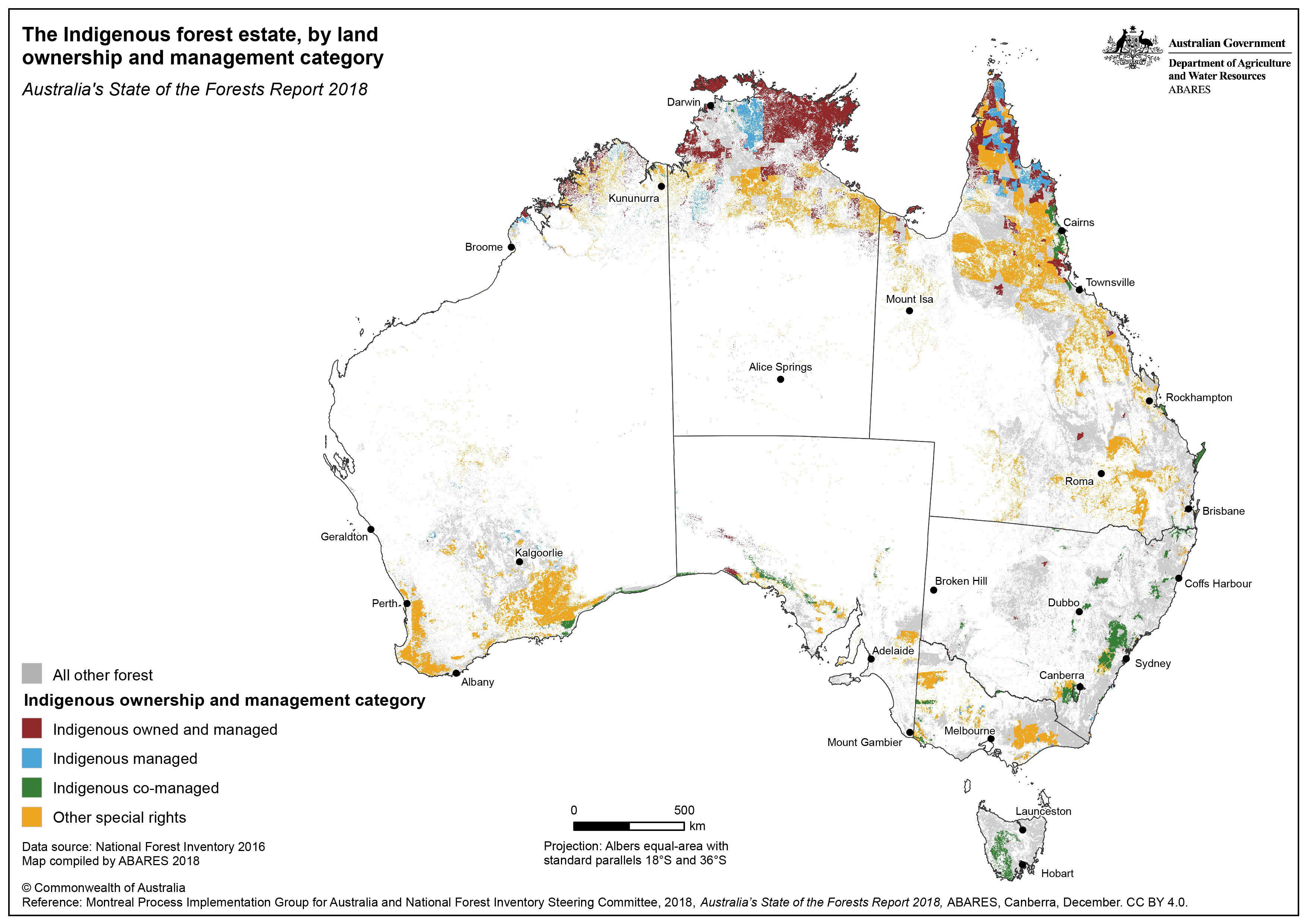
Click here for a downloadable higher resolution version of the Indigenous estate map.
The involvement of Indigenous peoples and communities in land and forest management is reported nationally in two indicators of Australia’s State of the Forests Report (Indicator 6.4c, The extent to which Indigenous values are protected, maintained and enhanced through Indigenous participation in forest management, and Indicator 6.1b, Values, quantities and use of non-wood forest products), and in the Indigenous chapter of Australia State of the Environment 2021 report.
Case studies in Indicator 6.4c of Australia’s State of the Forests Report 2018 include:
- Safeguarding Aboriginal heritage in Western Australian forests (Case study 6.8)
- West Kimberley National Heritage Place (Case study 6.9)
- Warddeken Indigenous Protected Area (Case study 6.11)
- Forestry Corporation of New South Wales engagement with the Aboriginal community (Case study 6.12)
- Indigenous forestry (Case study 6.13)
- Gumgali walking track (Case study 6.14)
- Cultural burning (Case study 6.15)
- Cultural heritage assessments (Case study 6.16).
Topics and case studies in Indicator 6.1b of Australia’s State of the Forests Report 2018:
- Bushfoods and non-wood forest products
- Commercial harvest of Kakadu plum (Case study 6.1).
Indigenous management of natural environments is also covered in the Indigenous chapter of the Australia State of the Environment 2021 report.
The participation and employment of Indigenous peoples and communities in the forest sector is reported nationally in Australia’s State of the Forests Report in Indicator 6.5d (Resilience of forest dependent Indigenous communities to changing social and economic conditions). Topics include employment, community adaptive capacity, and education and training, and a map of Indigenous Locations, by proportion of the Indigenous workforce employed in forest and wood products industries (see image below).
Indigenous forestry is covered in Case study 6.13 of Indicator 6.4c of Australia’s State of the Forests Report 2018.
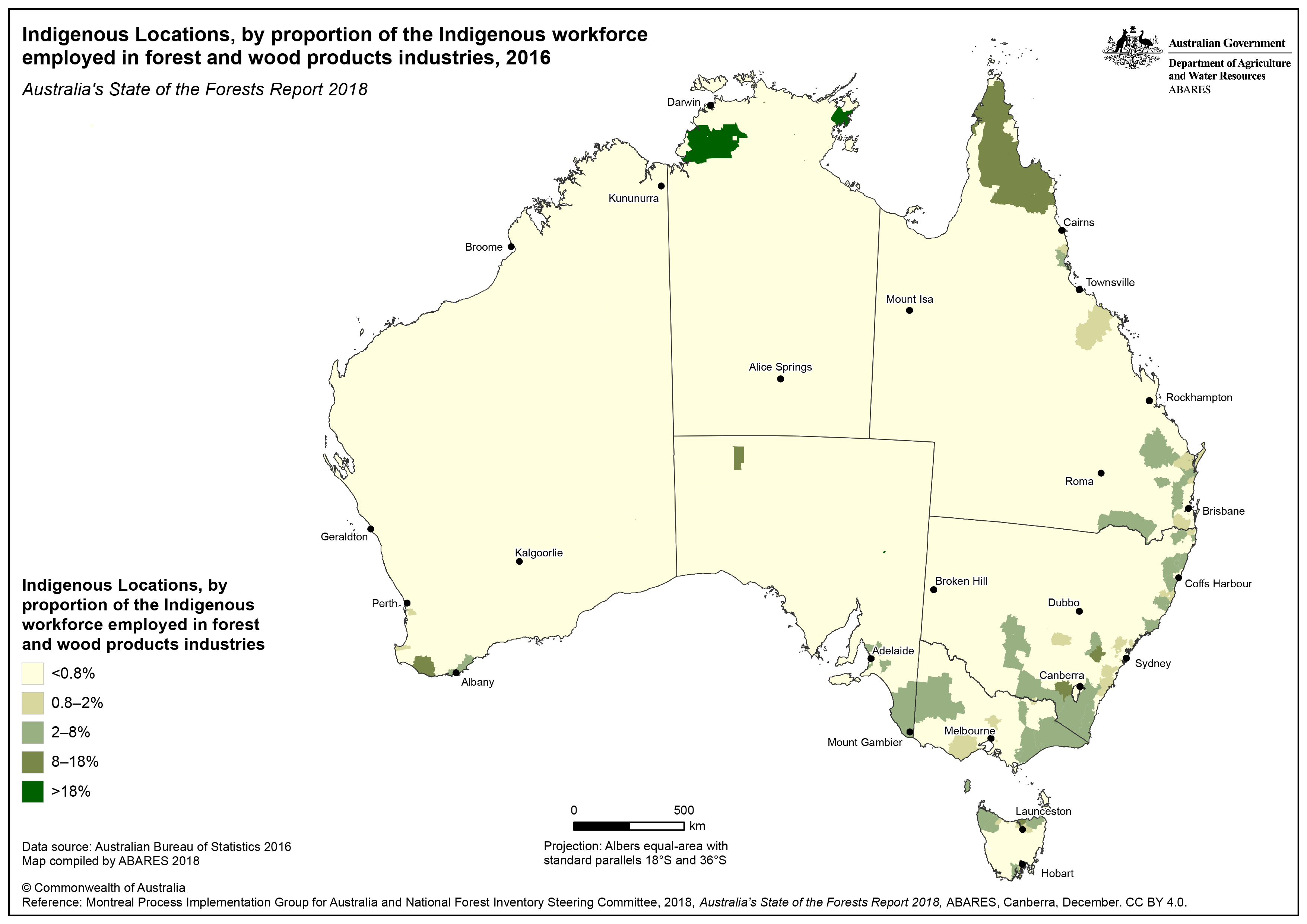
Click here for a downloadable higher resolution version of the Indigenous Locations map.
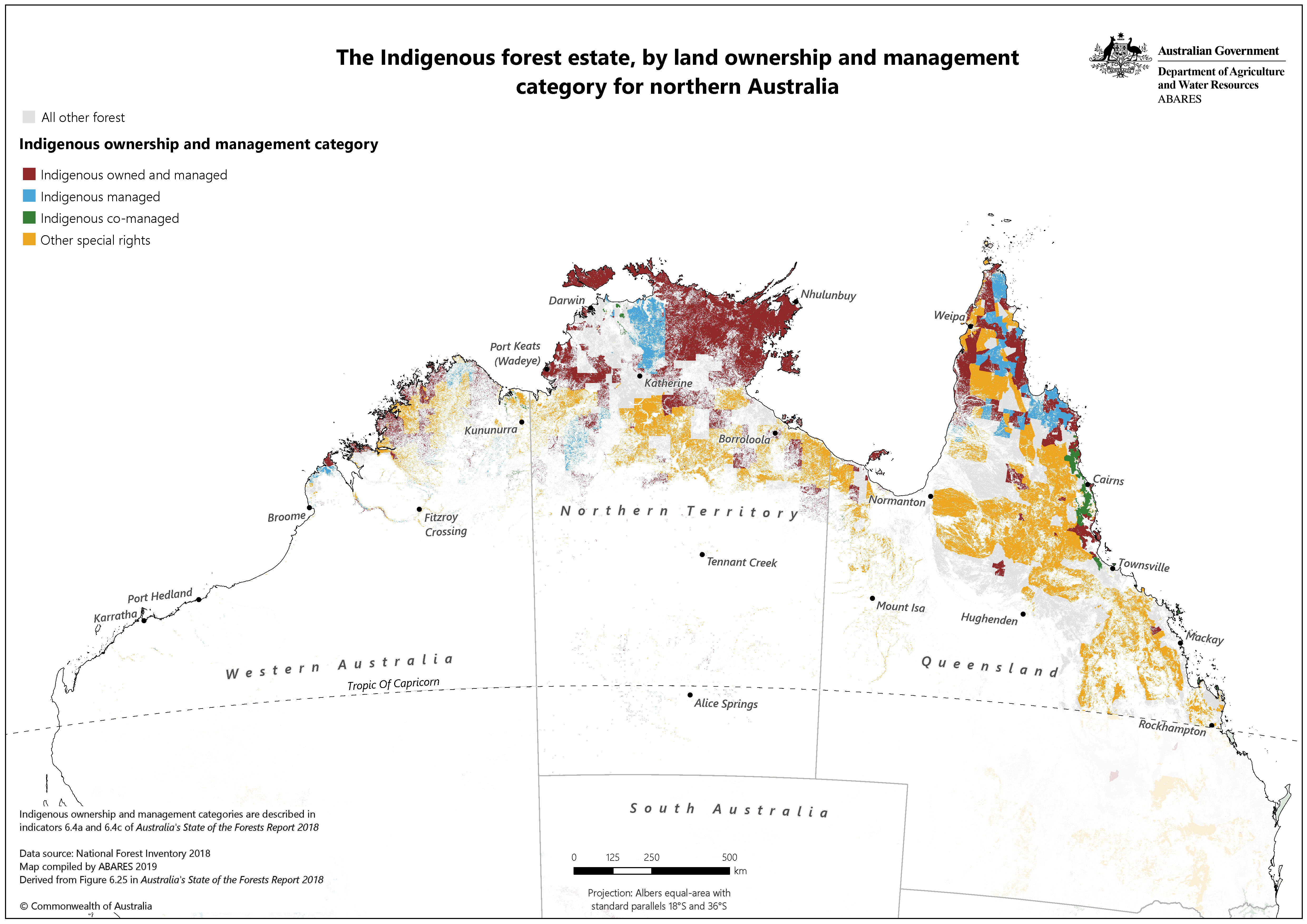
A map of the Indigenous forest estate, by land ownership and management category, for Northern Australia (see image below) was published in Northern forestry and forest products situational analysis (April 2020), a report for the CRC for Developing Northern Australia. The report provides a high-level synopsis of the Northern Australian forestry and forest products industry and describes its challenges, potential solutions and opportunities for further policy development, research or investment. One of six recommendations for action in the report is to: Promote Indigenous forestry development through better engagement models and commercial arrangements between industry and indigenous landowners, and build indigenous forestry capacity and understanding of commercial forest resources including through forest resource inventory.