Skip to main content Skip to main navigation Skip to search
ABARES - Land use and management

Top navigation abares

  • Department
  • Ministers
  • Media Centre
Main menu

Main navigation ACLUMP

  • Land home
    Land home
  • About ACLUMP
    About ACLUMP
  • Land use
    Land use
  • Publications
    Publications
  • Data download
    Data download
  • Latest news
    Latest news
ACLUMP

Breadcrumb

  1. AWE Home
  2. ABARES
  3. Land use and management

Land use and management

Integrated land information and mapping for Australia.

Secondary ACLUMP

  • ACLUMP
    • About ACLUMP
    • Latest news
    • Land data and maps
    • Land use
      • Land use mapping
      • Catchment scale land use of Australia and Commodities – Update December 2023
      • Catchment scale land use profiles
      • Mapping technical specifications
      • Land use apps
      • Data download
      • Publications
      • Australian Land Use and Management Classification
        • ALUM Classification Version 8 (October 2016)
      • Australian Agricultural Census 2020–21 visualisations
      • Land use of Australia 2010–11 to 2020–21
    • Land Management Practices
      • Collating LMP Information
      • Data and Maps
      • Drivers for LMP Information
      • Information System
      • Mapping ground cover management
      • Publications
    • Land tenure
      • Land tenure of Australia 2010–11 to 2020–21
    • Land Cover
      • Dynamic land cover
      • Ground cover monitoring for Australia
      • Ground cover indicator for drought resilience
      • Publications
    • Land Use Change Overview
      • Catchment scale examples
      • National scale examples
    • Publications
    • Definitions
    • Multi-Criteria Analysis Shell for Spatial Decision Support
      • MCAS-S tool
      • MCAS-S user guide
      • Australian national map layers
      • Quick Start Guide
        • 1. Introduction
        • 2. Set Up
        • 3. Input and Classification
        • 4. Composition and Comparison
        • 5. Building Criteria
        • 6. Reporting and Analysis
        • 7. Exporting
      • Preparing your own data
      • Updates
      • Disclaimer
      • MCAS-S-version-4

​​​​​This website is an information hub to assist land managers, planners and others who need to know more about land use, land management practices and land cover data and information for Australia.

It contains information about land use, land management practices and land cover mapping in Australia, access to national classification systems, technical reports supporting mapping work, and analysis of land information.

This site provides access to downloadable data and the ability to view data using different analytical mapping tools.

The Land Use and Management Information for Australia website is maintained by ABARES on behalf of the Australian Collaborative Land Use and Management Program​ (ACLUMP​).​​


​CLUM_2023v2_SimplifiedLandUse

​NLUM_2020-21_SimplifiedLandUse​


18 class land use legend crop

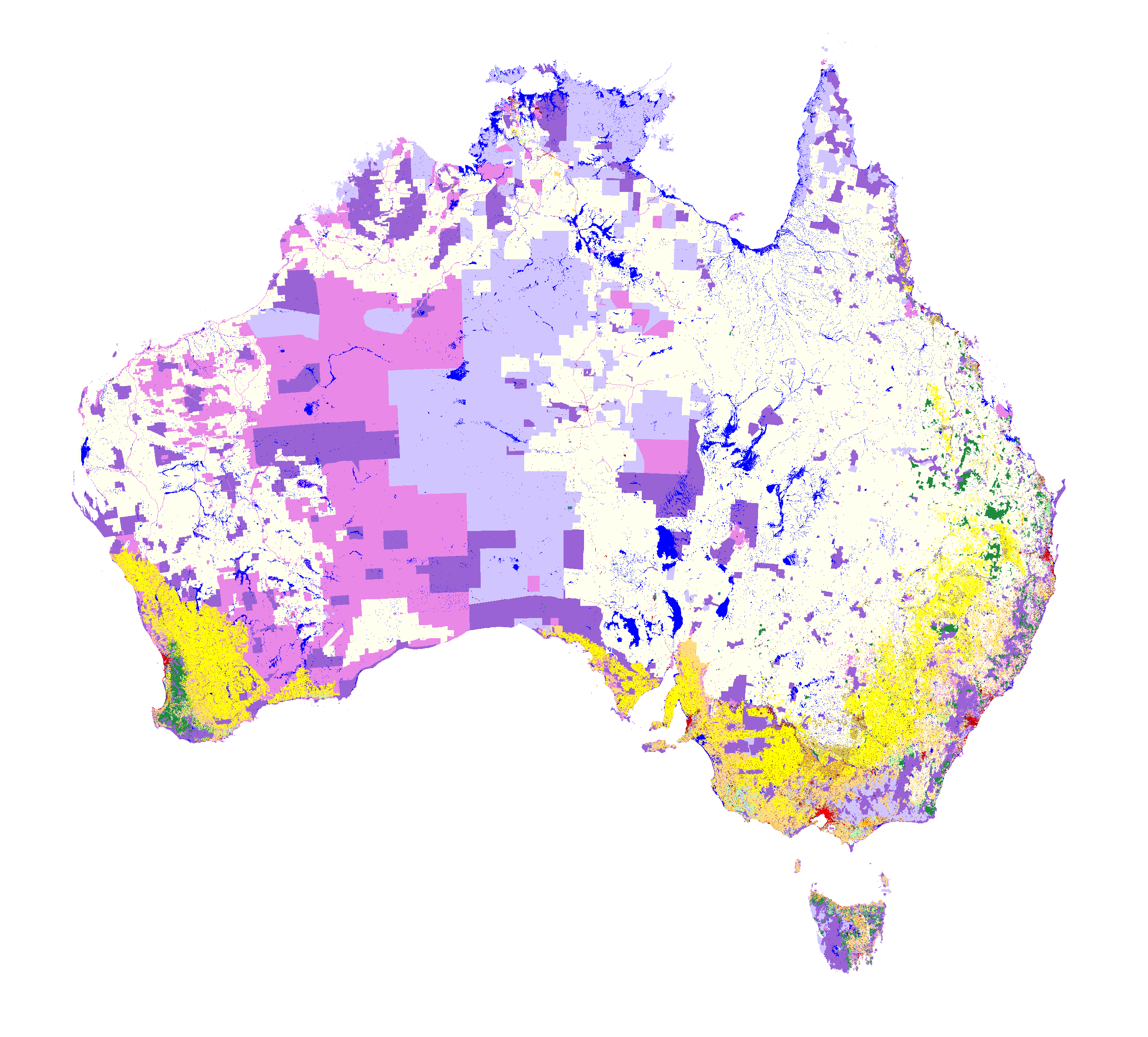
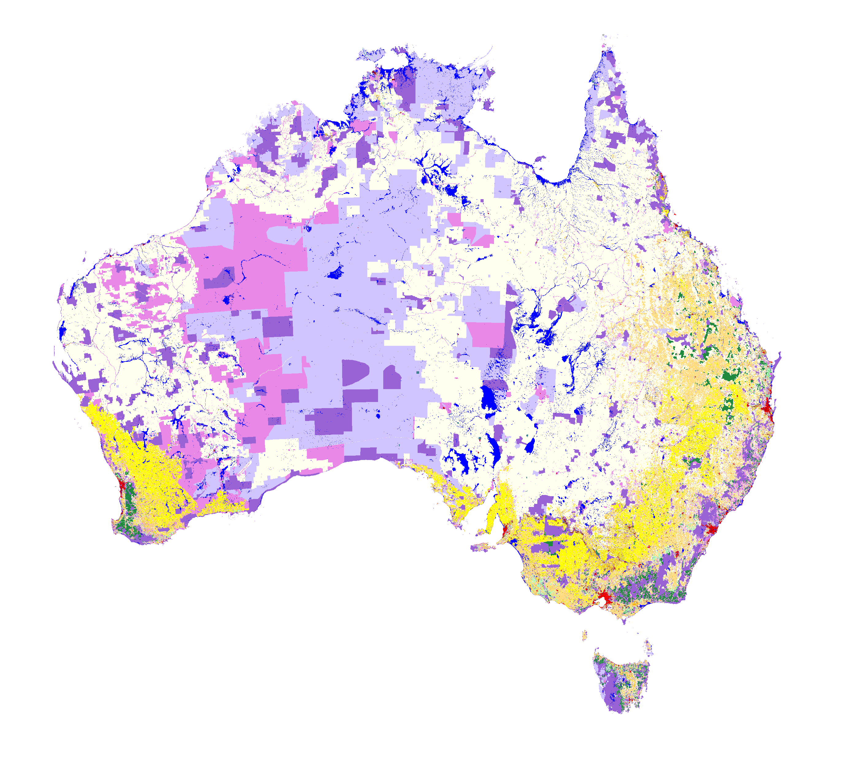
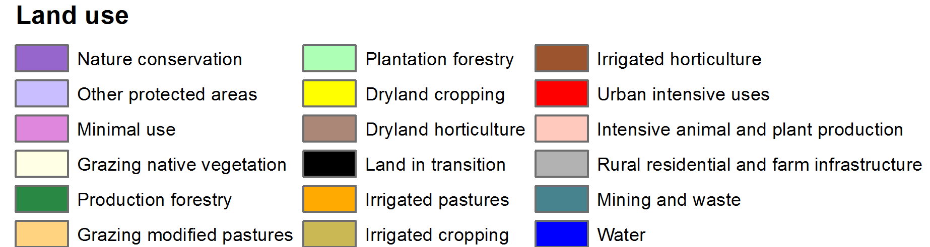
ACLUMP's land use products, left: Catchment Scale Land Use of Australia - Update December 2023, right: National Scale Land Use of Australia 2020-21 (click on image to link to metadata details or learn more about the different scales of land use mapping)

  • Land use
  • Land management practices
  • Land cover
  • MCAS-S​

​​

Quick links and downloads

  • Land Use Information for Australia brochure
  • Land Use ​in​ Australia at a Glance​​​​
  • ​Catchment Scale Land Use of Australia - Update December 2023​​
  • Catchment scale land use profiles​
  • Australian Agricultural Census 2020–21 visualisations​
  • ALUM Version 8
  • Land use data download

Can't find what you are looking for?

Thanks for your feedback.
Thanks! Your feedback has been submitted.

We aren't able to respond to your individual comments or questions.
To contact us directly phone us or submit an online inquiry

CAPTCHA
This question is for testing whether or not you are a human visitor and to prevent automated spam submissions.

Please verify that you are not a robot.

Skip
Page last updated: 28 November 2024

We acknowledge the continuous connection of First Nations Traditional Owners and Custodians to the lands, seas and waters of Australia. We recognise their care for and cultivation of Country. We pay respect to Elders past and present, and recognise their knowledge and contribution to the productivity, innovation and sustainability of Australia’s agriculture, fisheries and forestry industries.

Artwork: Protecting our Country, Growing our Future
© Amy Allerton, contemporary Aboriginal Artist of the Gumbaynggirr, Bundjalung and Gamilaroi nations.

Footer

  • Contact us
  • Accessibility
  • Disclaimer
  • Privacy
  • FOI

© Department of Agriculture, Fisheries and Forestry

Facebook X LinkedIn Instagram